
Amphoe Nopphitam
Encyclopedia
Nopphitam is a district (Amphoe
) of Nakhon Si Thammarat Province
, southern Thailand
.
.
Following a decision of the Thai government on May 15, 2007, all of the 81 minor districts were to be upgraded to full districts. With the publishing in the Royal Gazette on August 24 the upgrade became official
.
, Tha Sala
, Phrom Khiri
and Phipun
of Nakhon Si Thammarat Province and Ban Na San
and Kanchanadit
of Surat Thani Province
.
Nopphitam contains the northernmost part of the Khao Luang National Park, protecting a large part of the Nakhon Si Thammarat mountain range
.
), which are further subdivided into 38 villages (muban
). There are no municipal (thesaban
) areas, and 4 Tambon administrative organizations (TAO).
Amphoe
An amphoe is the second level administrative subdivision of Thailand. Usually translated as district, amphoe make up the provinces, and are analogous to a county seat...
) of Nakhon Si Thammarat Province
Nakhon Si Thammarat Province
Nakhon Si Thammarat is one of the southern provinces of Thailand, at the eastern shore of the Gulf of Thailand...
, southern Thailand
Southern Thailand
Southern Thailand is a distinct region of Thailand, connected with the Central region by the narrow Kra Isthmus.-Geography:Southern Thailand is located on the Malay Peninsula, with an area around 70,713 km², bounded to the north by Kra Isthmus as the narrowest part of the peninsula. The...
.
History
The district was created on April 1, 1995 by splitting off the four western tambon from Tha Sala districtAmphoe Tha Sala
Tha Sala is a district of Nakhon Si Thammarat Province, southern Thailand.-Geography:Neighboring districts are Mueang Nakhon Si Thammarat, Phrom Khiri, Nopphitam and Sichon...
.
Following a decision of the Thai government on May 15, 2007, all of the 81 minor districts were to be upgraded to full districts. With the publishing in the Royal Gazette on August 24 the upgrade became official
.
Geography
Neighboring districts are (from the northeast clockwise) SichonAmphoe Sichon
Sichon is a district of Nakhon Si Thammarat Province, southern Thailand.-Geography:The district is located in the northern part of the province. Neighboring districts are Tha Sala and Nopphitam of Nakhon Si Thammarat Province, Kanchanadit and Don Sak of Surat Thani Province, and Khanom of Nakhon...
, Tha Sala
Amphoe Tha Sala
Tha Sala is a district of Nakhon Si Thammarat Province, southern Thailand.-Geography:Neighboring districts are Mueang Nakhon Si Thammarat, Phrom Khiri, Nopphitam and Sichon...
, Phrom Khiri
Amphoe Phrom Khiri
Phrom Khiri is a district of Nakhon Si Thammarat Province, southern Thailand.-History:On August 26, 1974 the minor district Phrom Khiri was formed with the three tambon Phrom Lok, Ban Ko and In Khiri split from Mueang Nakhon Si Thammarat district...
and Phipun
Amphoe Phipun
Phipun is a district in the northern part of Nakhon Si Thammarat Province, southern Thailand.-Geography:Neighboring districts are Nopphitam, Phrom Khiri, Lan Saka, Chawang of Nakhon Si Thammarat Province, Wiang Sa and Ban Na San of Surat Thani Province.-History:The minor district was created on...
of Nakhon Si Thammarat Province and Ban Na San
Amphoe Ban Na San
-Geography:Neighboring districts are Nopphitam and Phipun of Nakhon Si Thammarat Province, Wiang Sa, Khian Sa, Ban Na Doem, Mueang Surat Thani and Kanchanadit....
and Kanchanadit
Amphoe Kanchanadit
Kanchanadit is a district in the province Surat Thani in the south of Thailand.-History:Originally the town was named Thathong and was located at the shore of Khlong Thathong Mai . During the reign of King Nangklao the town was moved because its location was malaria-infested, and renamed to...
of Surat Thani Province
Surat Thani Province
Surat Thani is the largest of the southern provinces of Thailand, on the eastern shore of the Gulf of Thailand. Surat Thani means City of Good People, the title given to the city by King Vajiravudh ....
.
Nopphitam contains the northernmost part of the Khao Luang National Park, protecting a large part of the Nakhon Si Thammarat mountain range
Nakhon Si Thammarat mountain range
The Nakhon Si Thammarat mountain range is a mountain range on the Malay peninsula in southern Thailand, running in a north-south direction. This mountain chain is also sometimes named Banthat mountain range , a name which is however also used to refer to the Chanthaburi mountain...
.
Administration
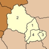
The district is subdivided into 4 subdistricts (tambonTambon
Tambon is a local government unit in Thailand. Below district and province , they form the third administrative subdivision level. As of the 2009 there are 7255 tambon, not including the 169 khwaeng of Bangkok, which are set at the same administrative level, thus every district contains 8-10 tambon...
), which are further subdivided into 38 villages (muban
Muban
Muban is the lowest administrative subdivision of Thailand. Usually translated as village, they are the subdivision of tambon. As of 2008, there are 74944 administrative villages in Thailand. As of the 1990 census, the average village consisted of 144 households or 746 persons.A muban does not...
). There are no municipal (thesaban
Thesaban
Thesaban are the municipalities in Thailand. There are three levels of municipalities - city, town and subdistrict municipality. Both Bangkok and Pattaya are special municipal entities outside the thesaban system....
) areas, and 4 Tambon administrative organizations (TAO).
|
 |