

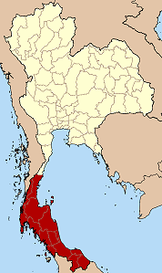
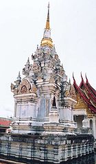
Southern Thailand
Encyclopedia
Thailand
Thailand , officially the Kingdom of Thailand , formerly known as Siam , is a country located at the centre of the Indochina peninsula and Southeast Asia. It is bordered to the north by Burma and Laos, to the east by Laos and Cambodia, to the south by the Gulf of Thailand and Malaysia, and to the...
, connected with the Central
Central Thailand
Central Thailand is a region of Thailand, covering the broad alluvial plain of the Chao Phraya River. It is separated from North-East Thailand by the Phetchabun mountain range, and another mountain range separates it from Myanmar to the west. In the north it gently changes into the more hilly...
region by the narrow Kra Isthmus
Kra Isthmus
The Kra Isthmus is the narrow land bridge which connects the Malay Peninsula with the mainland of Asia, and popularly named "The Devil's Neck".-Geography:...
.
Geography
Malay Peninsula
The Malay Peninsula or Thai-Malay Peninsula is a peninsula in Southeast Asia. The land mass runs approximately north-south and, at its terminus, is the southern-most point of the Asian mainland...
, with an area around 70,713 km², bounded to the north by Kra Isthmus
Kra Isthmus
The Kra Isthmus is the narrow land bridge which connects the Malay Peninsula with the mainland of Asia, and popularly named "The Devil's Neck".-Geography:...
as the narrowest part of the peninsula. The western part has steeper coasts, while on the east side river plains dominate. The largest river of the south is the Tapi
Tapi River, Thailand
The Tapi river is the longest river in southern Thailand. The river originates at the Khao Luang, and has a wide estuary into the Gulf of Thailand at Bandon Bay near the town of Surat Thani. It has a length of 230 km....
in Surat Thani
Surat Thani Province
Surat Thani is the largest of the southern provinces of Thailand, on the eastern shore of the Gulf of Thailand. Surat Thani means City of Good People, the title given to the city by King Vajiravudh ....
, which together with the Phum Duang
Phum Duang River
The Phum Duang River is a river in Surat Thani Province, Southern Thailand, the main tributary of the Tapi River....
in Surat Thani
Surat Thani Province
Surat Thani is the largest of the southern provinces of Thailand, on the eastern shore of the Gulf of Thailand. Surat Thani means City of Good People, the title given to the city by King Vajiravudh ....
drains more than 8,000 km², more than 10% of the total area of Southern Thailand. Smaller rivers include the Pattani
Pattani River
Pattani River is a river in Southern Thailand, Thailand. It originates in Betong district, Yala Province and mouths into the Gulf of Thailand at the town Pattani. Within Yala province the river forms the Bang Lang Reservoir. The river has a length of 214 km....
, Saiburi, Krabi
Krabi River
The Krabi River is a river in Southern Thailand, named after the town Krabi. The Krabi river is 5 kilometres long, as it is the main channel within a larger estuary to the Andaman Sea. The other two main channels are the Yuan River to the south and Chi Lat to the west...
and the Trang. The biggest lake of the south is the Songkhla lake
Songkhla Lake
The Songkhla lake is the largest natural lake in Thailand, located on the Malay peninsula in the southern part of the country. Covering an area of 1,040 km² it borders the provinces of Songkhla and Phatthalung. Despite being called a lake, this water surface is actually a lagoon complex...
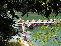
(1,040 km² altogether), the largest artificial lake is the Chiao Lan (Ratchaprapha dam) with 165 km² within the Khao Sok
Khao Sok
Khao Sok national park is located in Surat Thani province in Thailand. Its land area is 739 km², and it includes the Chiao Lan reservoir dammed by the Ratchaprapha dam. The park comprises the largest area of virgin forest in Southern Thailand and is a remnant of rainforest which is older and more...
national park in Surat Thani
Surat Thani Province
Surat Thani is the largest of the southern provinces of Thailand, on the eastern shore of the Gulf of Thailand. Surat Thani means City of Good People, the title given to the city by King Vajiravudh ....
.
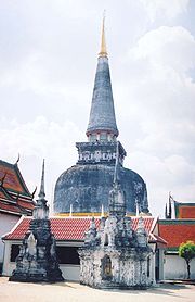
Surat Thani
Surat Thani Province
Surat Thani is the largest of the southern provinces of Thailand, on the eastern shore of the Gulf of Thailand. Surat Thani means City of Good People, the title given to the city by King Vajiravudh ....
Khao Luang
Khao Luang is the tallest mountain in southern Thailand. It is located in Nakhon Sri Thammarat province.-Geography:The Khao Luang mountain is the highest summit of a massif of several hills with steep slopes...
in the Nakhon Si Thammarat Province. Ranging from the Kra Isthmus till the Phuket
Phuket Province
Phuket , formerly known as Thalang and, in Western sources, Junk Ceylon , is one of the southern provinces of Thailand...
island is the Phuket chain
Phuket mountain range
The Phuket mountain range is a mountain range in the Kra Isthmus, Thailand.-Geography:This chain of hills is one of the southern sections of the central cordillera, the mountain chain which runs from Tibet through all of the Malay peninsula....
, which connects to the Tanao Si Mountain Range further north. Almost parallel to the Phuket chain but 100 km to the east is the Nakhon Si Thammarat or Banthat chain
Nakhon Si Thammarat mountain range
The Nakhon Si Thammarat mountain range is a mountain range on the Malay peninsula in southern Thailand, running in a north-south direction. This mountain chain is also sometimes named Banthat mountain range , a name which is however also used to refer to the Chanthaburi mountain...
, which begins with the Samui island
Ko Samui
Ko Samui island of Surat Thani Province , or often, simply Samui as it is referred to by locals, is an island off the east coast of the Kra Isthmus in Thailand, close to the mainland Surat Thani town. It is Thailand's second largest island, with an area of 228.7 km2 and a population of over...
Ko Pha Ngan
Ko Pha Ngan
Ko Pha Ngan is an island in the Gulf of Thailand in South East Thailand. It is famous for its full moon party at Haad Rin Beach and as a backpackers destination. Ko Pha Ngan has two sister islands: the larger Ko Samui to the south and the smaller Ko Tao to the north.* Area: about 168 km²*...
Ko Tao
Ko Tao
Ko Tao is an island in Thailand located near the western shore of the Gulf of Thailand. It covers an area of about 21 km². Administratively it forms a tambon within the district Ko Pha Ngan of Surat Thani Province. As of 2006 its official population is 1382...
in Surat Thani
Surat Thani Province
Surat Thani is the largest of the southern provinces of Thailand, on the eastern shore of the Gulf of Thailand. Surat Thani means City of Good People, the title given to the city by King Vajiravudh ....
and ends at the Malaysian border at the Ko Ta Ru Tao archipelago. The border to Malaysia is formed by the Sankalakhiri range
Sankalakhiri mountain range
The Sankalakhiri mountain range is the natural border between Thailand and Malaysia.This mountain range is a part of the Tenasserim Hills system...
, sometimes subdivided into the Pattani, Taluban and Songkhla chain. At the border to Malaysia begins the Titiwangsa chain
Titiwangsa Mountains
The Titiwangsa Mountains are the main mountain range that forms the backbone of the Malay Peninsula.-Geology:...
.
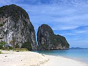
The limestone of the western coast has been eroded into many steep singular hills. Those parts submerged by the rising sea after the last ice age now form the many islands, like the well known Phi Phi Islands
Phi Phi Islands
The Phi Phi Islands are located in Thailand, between the large island of Phuket and the western Andaman Sea coast of the mainland. The islands are administratively part of Krabi province...
. Also quite famous is the so-called James Bond Island in the Phang Nga Bay
Phang Nga Bay
Phang Nga Bay is a 400 km² bay in the Andaman Sea between the island of Phuket and the mainland of the Malay peninsula of southern Thailand. Since 1981, an extensive section of the bay has been protected as the Ao Phang Nga National Park...
, which featured in the movie The Man with the Golden Gun
The Man with the Golden Gun (film)
The Man with the Golden Gun is the ninth spy film in the James Bond series and the second to star Roger Moore as the fictional MI6 agent James Bond...
.
History
In the first millennium
1st millennium
File:1st millennium montage.png|From left, clockwise: Depiction of Jesus, the central figure in Christianity; The Colosseum, a landmark of the once Roman Empire; Gunpowder is invented during the latter part of the millennium, in China; Chess, a new board game, takes on popularity across the globe;...
Chinese chronicles mention several coastal cities or city-states, however they don't give exact geographical location, so the identification of these cities with the later historical cities is difficult. The most important of these states were Langkasuka
Langkasuka
Langkasuka was an ancient Hindu Malay kingdom located in the Malay Peninsula...
, usually considered a precursor of the Pattani kingdom
Pattani kingdom
Pattani or Sultanate of Pattani was a Malay sultanate that covered approximately the area of the modern Thai provinces of Pattani, Yala, Narathiwat and much of the northern part of modern Malaysia. The King of Patani is believed to have converted to Islam some time during the 11th century...
; Tambralinga
Tambralinga
Tambralinga was an ancient kingdom located on the Malay Peninsula that at one time came under the influence of Srivijaya. The name had been forgotten until scholars recognized Tambralinga as Nagara Sri Dharmaraja. Early records are scarce while estimations range from the seventh to fourteenth...
, probably the precursor of the Nakhon Si Thammarat kingdom
Nakhon Si Thammarat kingdom
Nakhon Si Thammarat Kingdom was one of the major constituent city states of the Siamese kingdoms of Sukhothai and later Ayutthaya and controlled a big part of the Malay peninsula...
, or P'an-p'an
Pan Pan
Pan Pan is a lost small Hindu Kingdom believed to have existed around 3rd-7th Century CE., somewhere in Kelantan or Terengganu, Malaysia. Little is known about this kingdom. The kingdom was later conquered by Srivijaya under the leadership of Dharmasetu before 775 CE...
in Phunphin district Surat Thani, probably located at the Bandon Bay
Bandon Bay
Bandon Bay is a bay in the Gulf of Thailand in the Surat Thani Province, extending from the Sui cape in Chaiya district in the northwest to the Kanchanadit district to the east. The total coastline is about 100 km. The bay is dominated by the estuary of the rivers Tapi and Phum Duang...
Tapi River
Tapi River, Thailand
The Tapi river is the longest river in southern Thailand. The river originates at the Khao Luang, and has a wide estuary into the Gulf of Thailand at Bandon Bay near the town of Surat Thani. It has a length of 230 km....
. The cities were highly influenced by Indian culture, and have adopted Brahman
Brahman
In Hinduism, Brahman is the one supreme, universal Spirit that is the origin and support of the phenomenal universe. Brahman is sometimes referred to as the Absolute or Godhead which is the Divine Ground of all being...
or Buddhist religion. When Srivijaya
Srivijaya
Srivijaya was a powerful ancient thalassocratic Malay empire based on the island of Sumatra, modern day Indonesia, which influenced much of Southeast Asia. The earliest solid proof of its existence dates from the 7th century; a Chinese monk, I-Tsing, wrote that he visited Srivijaya in 671 for 6...
in Chaiya
Chaiya
Chaiya is a district and town in Surat Thani Province in southern Thailand. The town itself has a population of 13,133 , while the whole district has a population of 47,750.-Geography:...
extended its sphere of influence, those cities became tributary states of Srivijaya.The city Chaiya
Chaiya
Chaiya is a district and town in Surat Thani Province in southern Thailand. The town itself has a population of 13,133 , while the whole district has a population of 47,750.-Geography:...
in Surat Thani Province
Surat Thani Province
Surat Thani is the largest of the southern provinces of Thailand, on the eastern shore of the Gulf of Thailand. Surat Thani means City of Good People, the title given to the city by King Vajiravudh ....
contains several ruins from Srivijaya times, and was probably a regional capital of the kingdom. Some Thai historians even claim that it was the capital of the kingdom itself for some time, but this is generally disputed.
After Srivijaya lost its influence, Nakhon Si Thammarat became the dominant kingdom of the area. During the rule of King Ramkhamhaeng the Great
Ramkhamhaeng the Great
Pho Khun Ram Khamhaeng was the third king of the Phra Ruang dynasty, ruling the Sukhothai Kingdom from 1279–1298, during its most prosperous era. He is credited with the creation of the Thai alphabet and the firm establishment of Theravada Buddhism as the state religion of the kingdom...
of Sukhothai
Sukhothai kingdom
The Sukhothai Kingdom ) was an early kingdom in the area around the city Sukhothai, in north central Thailand. The Kingdom existed from 1238 till 1438...
, Thai influence first reached Nakhon Si Thammarat. According to the Ramkhamhaeng inscription Nakhon was even a tributary state of Sukhothai. During most of the later history Nakhon became a tributary of Ayutthaya
Ayutthaya kingdom
Ayutthaya was a Siamese kingdom that existed from 1350 to 1767. Ayutthaya was friendly towards foreign traders, including the Chinese, Vietnamese , Indians, Japanese and Persians, and later the Portuguese, Spanish, Dutch and French, permitting them to set up villages outside the walls of the...
.
The deep south belonged to the Malay sultanates of Pattani
Pattani kingdom
Pattani or Sultanate of Pattani was a Malay sultanate that covered approximately the area of the modern Thai provinces of Pattani, Yala, Narathiwat and much of the northern part of modern Malaysia. The King of Patani is believed to have converted to Islam some time during the 11th century...
and Kedah
Kedah
Kedah is a state of Malaysia, located in the northwestern part of Peninsular Malaysia. The state covers a total area of over 9,000 km², and it consists of the mainland and Langkawi. The mainland has a relatively flat terrain, which is used to grow rice...
, while the northernmost part of the peninsula was under direct control of Bangkok.
During the thesaphiban reforms at the end of the 19th century, both Nakhon Si Thammarat as well as Pattani were finally incorporated into the central state. The area was subdivided into 5 monthon
Monthon
A monthon |]], literally "circle") was a country subdivision of Thailand in the beginning of the 20th century. The Thai word 'monthon' is a translation of the word Mandala. These were created as a part of the thesaphiban bureaucratic administrative system, introduced by Prince Damrong Rajanubhab...
, which were installed to control the city states (mueang
Mueang
Mueang were historical semi-independent city-states or principalities in present-day Thailand, Laos, parts of northern Vietnam and the Shan State of Myanmar. Smaller Mueang were subordinate to more powerful neighboring Mueang, which in turn were subordinate to the central king, as described in...
). Minor mueang were merged into larger ones, thus forming the present 14 provinces. With the Anglo-Siamese Treaty of 1909
Anglo-Siamese Treaty of 1909
The Anglo-Siamese Treaty of 1909 or Bangkok Treaty of 1909 was a treaty between the United Kingdom and the Kingdom of Siam signed on March 10, 1909, in Bangkok. Ratifications were exchanged in London on July 9, 1909....
the boundary to Malaysia was fixed. Kedah came under British control, while Pattani stayed with Siam.
Administration
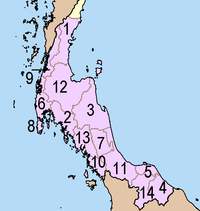
| Nr. | Name | Thai Thai alphabet Thai script , is used to write the Thai language and other, minority, languages in Thailand. It has forty-four consonants , fifteen vowel symbols that combine into at least twenty-eight vowel forms, and four tone marks .... |
Area | Inh. Population A population is all the organisms that both belong to the same group or species and live in the same geographical area. The area that is used to define a sexual population is such that inter-breeding is possible between any pair within the area and more probable than cross-breeding with individuals... |
Density | GPP(THB)(2007) | GPP/capita(2007) |
|---|---|---|---|---|---|---|---|
| 1. | Chumphon Chumphon Province Chumphon ) is one of the southern provinces of Thailand, at the shore of the Gulf of Thailand. Neighboring provinces are Prachuap Khiri Khan, Surat Thani and Ranong... |
ชุมพร | 6,009.00 | 485,713 | 80.83 | 45,580 | 92,192 |
| 2. | Krabi Krabi Province Krabi is one of the southern provinces of Thailand, at the shore of the Andaman Sea. Neighbouring provinces are Phang Nga, Surat Thani, Nakhon Si Thammarat and Trang. The Phuket province to the west is also neighbouring, but without any land boundary... |
กระบี่ | 4,708.00 | 417,735 | 88.73 | 41,383 | 108,629 |
| 3. | Nakhon Si Thammarat Nakhon Si Thammarat Province Nakhon Si Thammarat is one of the southern provinces of Thailand, at the eastern shore of the Gulf of Thailand... |
นครศรีธรรมราช | 9,942.50 | 1,512,249 | 152.10 | 123,614 | 73,960 |
| 4. | Narathiwat Narathiwat Province Narathiwat is one of the southern provinces of Thailand. Neighboring provinces are Yala and Pattani. To the south it borders the Malaysian state of Kelantan. The southern railway line ends in this province that is one of the nation’s five provinces that borders Malaysia. The name of this... |
นราธิวาส | 4,475.00 | 718,724 | 160.61 | 46,468 | 62,625 |
| 5. | Pattani Pattani Province Pattani is one of the southern provinces of Thailand. Neighboring provinces are Narathiwat, Yala and Songkhla.-Geography:... |
ปัตตานี | 1,940.40 | 641,187 | 330.44 | 39,534 | 59,618 |
| 6. | Phang Nga Phang Nga Province Phang Nga is one of the southern provinces of Thailand, on the shore to the Andaman Sea. Neighboring provinces are Ranong, Surat Thani and Krabi. To the south is the Phuket province, but without land boundary to Phang Nga.... |
พังงา | 4,170.00 | 250,079 | 59.97 | 29,828 | 114,988 |
| 7. | Phatthalung Phatthalung Province Phatthalung is one of the southern provinces of Thailand. Neighboring provinces are Nakhon Si Thammarat, Songkhla, Satun and Trang.-Geography:... |
พัทลุง | 3,423.50 | 504,470 | 147.36 | 33,259 | 60,677 |
| 8. | Phuket Phuket Province Phuket , formerly known as Thalang and, in Western sources, Junk Ceylon , is one of the southern provinces of Thailand... |
ภูเก็ต | 543.00 | 325,586 | 599.61 | 62,055 | 214,621 |
| 9. | Ranong Ranong Province Ranong is one of the southern provinces of Thailand, on the coast of the Andaman Sea. It is the province with the fewest citizens. Neighboring provinces are Chumphon, Surat Thani and Phang Nga... |
ระนอง | 3,298.00 | 191,744 | 58.14 | 17,309 | 94,640 |
| 10. | Satun Satun Province Satun is one of the southern provinces of Thailand. Neighboring provinces are Trang, Phatthalung and Songkhla... |
สตูล | 2,479.00 | 287,866 | 116.12 | 27,217 | 97,614 |
| 11. | Songkhla Songkhla Province Songkhla is one of the southern provinces of Thailand. Neighboring provinces are Satun, Phatthalung, Nakhon Si Thammarat, Pattani and Yala. To the south it borders Kedah and Perlis of Malaysia.... |
สงขลา | 7,393.90 | 1,329,635 | 179.69 | 168,611 | 119,620 |
| 12. | Surat Thani Surat Thani Province Surat Thani is the largest of the southern provinces of Thailand, on the eastern shore of the Gulf of Thailand. Surat Thani means City of Good People, the title given to the city by King Vajiravudh .... |
สุราษฎร์ธานี | 12,891.50 | 981,595 | 76.14 | 122,398 | 125,651 |
| 13. | Trang Trang Province Trang is one of the southern provinces of Thailand, at the western shore of the Malay Peninsula to the Andaman Sea. Neighboring provinces are Krabi, Nakhon Si Thammarat, Phatthalung and Satun.... |
ตรัง | 4,917.50 | 614,222 | 124.91 | 62,912 | 94,863 |
| 14. | Yala Yala Province Yala is the southernmost province of Thailand. Neighboring provinces are Songkhla, Pattani and Narathiwat. Yala is the only land-locked province in the south of Thailand... |
ยะลา | 4,521.10 | 474,559 | 104.97 | 39,198 | 84,614 |
Demography
Southern Thailand has around 8.734 million inhabitants and its population density is around 126 inh/km².'Ten Major Cities in Southern Thailand'
| Nr. | Name | Inh. Population A population is all the organisms that both belong to the same group or species and live in the same geographical area. The area that is used to define a sexual population is such that inter-breeding is possible between any pair within the area and more probable than cross-breeding with individuals... |
Metropolitan |
|---|---|---|---|
| 1. | Hat Yai Hat Yai Hat Yai is a city in southern Thailand near the Malaysian border. Located at , it has a population of 157,359 in the city itself and about 800,000 in the greater Hat Yai area. Hat Yai is the largest city of Songkhla Province, the largest metropolitan area in Southern, and third largest... |
157,359 | 801,747 in Greater Hatyai-Songkhla Metropolitan Area Greater Hatyai-Songkhla Metropolitan Area The Greater Hatyai–Songkhla Metropolitan Area is an urban corridor in Southern Thailand's Songkhla Province between two cities--Hat Yai, the commercial center of the province and the region, and Songkhla, the provincial capital. Located 30 km apart, the twin cities are complementary to each... Songkla Province. |
| 2. | Surat Thani Surat Thani Province Surat Thani is the largest of the southern provinces of Thailand, on the eastern shore of the Gulf of Thailand. Surat Thani means City of Good People, the title given to the city by King Vajiravudh .... |
126,280 | 358,000 in Surat Thani Metropolitan Area |
| 3. | Nakhon Si Thammarat Nakhon Si Thammarat Nakhon Si Thammarat is a town in southern Thailand, capital of the Nakhon Si Thammarat Province and the Nakhon Si Thammarat district. It is about south of Bangkok, on the east coast of the Malay Peninsula. The city was the administrative center of southern Thailand during most of its history. ... |
108,139 | 280,000 in Amphoe Mueang Nakhon Si Thammarat Amphoe Mueang Nakhon Si Thammarat Nakhon Si Thammarat is the capital district of Nakhon Si Thammarat Province in southern Thailand.-Geography:Neighboring districts are Pak Phanang, Chaloem Phra Kiat, Phra Phrom, Lan Saka, Phrom Khiri and Tha Sala... . |
| 4. | Phuket | 75,971 | 325,600 on Phuket Metropolitan Area. |
| 5. | Songkhla Songkhla Songkhla is a city in the Songkhla Province of southern Thailand, near the border with Malaysia. As of 2006 it had a population of 75,048... |
73,835 | 801,747 in Greater Hatyai-Songkhla Metropolitan Area Greater Hatyai-Songkhla Metropolitan Area The Greater Hatyai–Songkhla Metropolitan Area is an urban corridor in Southern Thailand's Songkhla Province between two cities--Hat Yai, the commercial center of the province and the region, and Songkhla, the provincial capital. Located 30 km apart, the twin cities are complementary to each... . |
| 6. | Yala Yala, Thailand Yala is a city in the extreme south of Thailand near the Malaysian border, and is administrative capital of Yala Province. The 2005 estimated population was 65,000. The city covers the whole tambon Sateng of Mueang Yala district.... |
63,640 | |
| 7. | Trang Trang Trang is the capital of Trang Province, Thailand. The city has a population of 59,637 and covers the whole tambon Thap Thiang of Mueang Trang district.... |
61,067 | |
| 8. | Ko Samui Ko Samui Ko Samui island of Surat Thani Province , or often, simply Samui as it is referred to by locals, is an island off the east coast of the Kra Isthmus in Thailand, close to the mainland Surat Thani town. It is Thailand's second largest island, with an area of 228.7 km2 and a population of over... |
51,044 | Koh Samui Island Surat Thani Province. |
| 9. | Ko Hong | 43,989 | 801,747 in Greater Hatyai-Songkhla Metropolitan Area Greater Hatyai-Songkhla Metropolitan Area The Greater Hatyai–Songkhla Metropolitan Area is an urban corridor in Southern Thailand's Songkhla Province between two cities--Hat Yai, the commercial center of the province and the region, and Songkhla, the provincial capital. Located 30 km apart, the twin cities are complementary to each... . |
| 10. | Pattani Pattani (town) Pattani is a town in the far south of Thailand, near the boundary to Malaysia. It is the capital of the Pattani Province. The city has a population of 43,631... |
43,255 |
More : List of metropolitan areas in Thailand by population
Economy
Main article GPP of Southern ThailandGPP of Southern Thailand
-GPP:GPP of Southern Thailand show in table below.-GPP per capita:GPP per capita in 2007, shown in THB...
In 2007, Southern Thailand had the GRP (Gross Regional Product) about 859,325 million Baht (25,274.06 million USD). The regional economic hubs of the region are Hat Yai City
Hat Yai
Hat Yai is a city in southern Thailand near the Malaysian border. Located at , it has a population of 157,359 in the city itself and about 800,000 in the greater Hat Yai area. Hat Yai is the largest city of Songkhla Province, the largest metropolitan area in Southern, and third largest...
for Lower Southern, Surat Thani City
Surat Thani Province
Surat Thani is the largest of the southern provinces of Thailand, on the eastern shore of the Gulf of Thailand. Surat Thani means City of Good People, the title given to the city by King Vajiravudh ....
for Upper Southern and Phuket City for Westcoast Southern.
Transportation
Southern Thailand is connected with Bangkok, the economic center of Thailand, by railway as well as highway. Also several regional airports are located at the larger towns. The main transportation hub of all southern Thailand is Hat Yai, which developed from a small village to the current city within few decades.Road
Phetkasem Road is the longest road in Thailand, running from Bangkok along the Kra Isthmus and then at the western coast of the peninsula. From Trang it crosses over to the eastern coast to Hat Yai, and then ends at the Malaysian border.Two Asian highways run through southern Thailand. Asian highway 2
AH2
The AH2 is a road in the Asian Highway Network running 8230 miles from Denpasar, Indonesia to Khosravi, Iran. The route is as follows:-Indonesia:Denpasar — Surabaya — Surakarta — Semarang — Cikampek — Jakarta...
runs mostly parallel to the railroad all the way from Bangkok. It crosses to Malaysia at Sadao
Sadao
-Places:* Sadao, Sadao - Sadao District - Songkhla Province, Southern Thailand* Sadao, Buachet - Buachet District - Surin Province North-Eastern Thailand* Sadao, Nang Rong - Nang Rong District - Buriram Province North-Eastern Thailand...
, and continues on the western part of the peninsula. Asian highway 18
AH18
Asian Highway Route is a highway route included in Asian Highway Network, running from Haadyai in Thailand to Johor Bahru, Malaysia. Route runs along main eastern coastal road in southern Thailand and also along Federal Route of Malaysia.- Thailand :...
begins in Hat Yai and runs south along the eastern coast, crossing to Malaysia at Sungai Kolok.
Rail
The southern railway also connects Bangkok to Hat Yai, and continues from there to Su-ngai Kolok. There are a branch from Ban Thung Phoe Junction to Kirirat Nikhom, two smaller branches of the railway run from Thung Song to Trang and Nakhon Si Thammarat, and from Hat Yai Junction to Malaysia and Singapore.Air
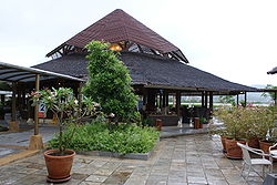
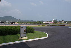
Southern Thailand has 5 international airports and 6 domestic airports named as follows.- Phuket International AirportPhuket International AirportPhuket International Airport is an airport serving the Phuket Province of Thailand. It is located in the north of Phuket Island, 32 kilometres from the centre of Phuket City. The airport plays a major role in Thailand's tourism industry, as Phuket Island is a popular resort destination...
(with international service) - Hat Yai International AirportHat Yai International AirportHat Yai International Airport is the major southern hub airport in Thailand, located near the city of Hat Yai. It is under the management of Airports of Thailand, PCL. It is also an important airport for Muslims on the pilgrimage to Mecca. Annually, more than 800,000 passengers, 9,500 flights...
(with international service) - Krabi International AirportKrabi AirportKrabi Airport , is the airport serving Krabi, Thailand - about from the city center.-Airlines and destinations:- Statistics :* Movements - 7,820* Passenger departures - 395,902* Transit - 427...
(with international service) - Surat Thani International AirportSurat Thani AirportSurat Thani Airport is situated in the Phunphin district, Surat Thani province, Thailand. The airport, which is located 21 km west of Surat Thani, is also the Wing 7 Airforce base...
- Koh Samui International AirportSamui AirportSamui International Airport , also known as Ko Samui Airport or Koh Samui Airport, is a privately owned airport on the island of Ko Samui in Thailand. The airport is located roughly 2 km north of the main village Chaweng....
(with international service) - Nakhon Si Thammarat AirportNakhon Si Thammarat AirportNakhon Si Thammarat Airport is an airport serving Nakhon Si Thammarat, a town in the Nakhon Si Thammarat Province of Thailand. Nakhon Si Thammarat Airport is located in Muang district, Nakhon Si Thammarat Province away from city of Nakhon Si Thammarat 14 Kilometers. Capacity of arrival terminal ...
- Trang AirportTrang AirportTrang Airport is located in Tambon Khok Lo, Mueang Trang district, Trang Province, 7 km from Trang town centre.-Airline and destinations:- Statistics :* Movements - 870* Passenger departures - 51,992* Transit - 72...
- Narathiwat AirportNarathiwat AirportNarathiwat Airport is an airport in Narathiwat Province, Thailand.-Domestic Airlines:...
- Chumphon Airport
- Ranong AirportRanong AirportRanong Airport is an airport serving Ranong, a town in the Ranong Province of Thailand....
- Pattani AirportPattani AirportPattani Airport is an airport serving Pattani, a town in the Pattani Province of Thailand....
See also
- South Thailand insurgencySouth Thailand insurgencyAn ethnic separatist insurgency is taking place in Southern Thailand, predominantly in the Malay Pattani region, made up of the three southernmost provinces of Thailand. Violence has increasingly spilling over into other provinces...
- Yawi language
- OK BaytongOK BaytongOK Baytong is a 2003 Thai drama film about Buddhist-Muslim relations in southern Thailand. It is written and directed by Nonzee Nimibutr.-Plot:Tum is a young man who has been a monk living in a Buddhist temple in Thailand since he was 5 years old...
- Thai film set in Southern Thailand