
Amphoe Ban Na Doem
Encyclopedia
Geography
Ban Na Doem is located in the center of Surat Thani province. Neighboring district are (from the north clockwise) Mueang Surat ThaniAmphoe Mueang Surat Thani
Mueang Surat Thani is the capital district of Surat Thani Province in southern Thailand.-Geography:The district is located at the mouth of the Tapi River into the Bandon Bay of the Gulf of Thailand...
, Ban Na San
Amphoe Ban Na San
-Geography:Neighboring districts are Nopphitam and Phipun of Nakhon Si Thammarat Province, Wiang Sa, Khian Sa, Ban Na Doem, Mueang Surat Thani and Kanchanadit....
, Khian Sa
Amphoe Khian Sa
Khian Sa is a district in Surat Thani Province, Thailand.Neighboring districts are Khiri Rat Nikhom, Phunphin, Ban Na Doem, Ban Na San, Wiang Sa, Phrasaeng and Phanom...
and Phunphin.
The Tapi River
Tapi River, Thailand
The Tapi river is the longest river in southern Thailand. The river originates at the Khao Luang, and has a wide estuary into the Gulf of Thailand at Bandon Bay near the town of Surat Thani. It has a length of 230 km....
forms part of the western boundary of the district. A smaller river in the district is the Khlong Lamphun.
History
Lamphun district, one of the original districts of Surat Thani province, was administrated from the town of Ban Na, which is now the center of the Ban Na Doem district. On July 1, 1938 however the district office was moved to Na San and the district was renamed to Ban Na San one year later.Becoming effective on April 15, 1976 the area around Ban Na was split off from Ban Na San district and formed a new minor district (king amphoe). The minor district was originally subdivided into the two tambon Ban Na and Tha Ruea. August 15, 1982 the tambon Sap Thawi was split from Tha Ruea, on July 1, 1983 Na Tai from Ban Na.
On May 21, 1990 the minor district was elevated to full district status.
Administration
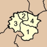
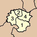
Ban Na Doem is subdivided into 4 subdistricts (tambonTambon
Tambon is a local government unit in Thailand. Below district and province , they form the third administrative subdivision level. As of the 2009 there are 7255 tambon, not including the 169 khwaeng of Bangkok, which are set at the same administrative level, thus every district contains 8-10 tambon...
), which are further subdivided into 30 villages (muban
Muban
Muban is the lowest administrative subdivision of Thailand. Usually translated as village, they are the subdivision of tambon. As of 2008, there are 74944 administrative villages in Thailand. As of the 1990 census, the average village consisted of 144 households or 746 persons.A muban does not...
). There is one township (thesaban tambon) Ban Na, covering parts of tambon Ban Na and Na Tai. Each tambon has a Tambon administrative organization (TAO), responsible for the area not covered by the township.
|
 |