

Amphoe Takua Pa
Encyclopedia
Takua Pa is a district (amphoe
) in the province Phang Nga
in the south of Thailand
.
. To the north of the district is the Si Phang-nga National Park
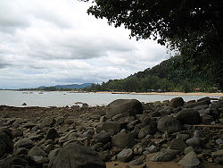
. The southern part of the district is covered by the Khao Lak-Lam Ru National Park, which includes the popular beach resort of Khao Lak
, devastated by the tsunami
resulting from the 2004 Indian Ocean earthquake
.
Neighboring districts are Khura Buri
to the north, Phanom
of Surat Thani Province
and Kapong
to the east, and Thai Mueang
to the south.
) dating back to Srivijaya
times in the 13th century. It was also known as Takkolam (Tamil
: தக்கொலம்) which is the Tamil
word for “piper cuveba’ and “calyptranthes jambalana. There is also a place in the Tamil country
which up to now carries the same name Takkolam. Takuapa could have been either abounded by the spices “calyptranthese jambalana” and “piper cubeba” or it could have been occupied by settlers from the Takkolam of the Tamil country
, or both. Takuapa is said to have been the finest harbor on the west coast of the peninsula for trade between the Malay kingdom of Sri Vijaya and the early South India
n Tamil
kingdoms of the Cholas and Pallavas during different times in history. It was later renamed to Takua Pa due to the rich ores near the town - Takua is the Thai word for lead
, even though tin
was the most important ore found there.
There was a Hindu/Vishnu temple in the 8th century AD.
An important mercantile organisation called 'Kodumbalur Manigramam', built a water tank for this temple. They have left an inscription in Tamil. The tank was called 'Avani Naaranam' - 'Avani Naaranan' was the name of one of the Pallava Emperors of Tamil Nadu.
The town was long administrated by Nakhon Si Thammarat
. In 1892 it was converted to a province, administered within the Monthon Phuket. This province was merged into Phang Nga province on April 1 1932. The district Talad Yai (big market, ตลาดใหญ่) was then renamed to Takua Pa.
The district was an important tin-dredging area in the first half of the twentieth century, with the English company Siamese Tin Syndicate Ltd., and the Australian company Satupulo No Liability Co. both operating dredges in the rivers, with narrow-gauge tramways following them upstream. The Asiatic Company also had a dredge and tramway further inland at Amphoe Kapong. Siamese Tin was operating here at least as late as 1967, but Thai magnates, such as the late Chuti Bunsung, took over operations by the early 1980s. By 2008 there was no sign left of the mining, as plantations, particularly rubber, have covered the former dredged areas. The public library at Takua Pa town has photographs on display of the dredging and sluicing operations in their heyday in the 1920s and 1930s. The former Asiatic Company workshops can also still be seen in Amphoe Kapong town.
The centre for the identification of bodies found after the 2004 tsunami is located in the district. Opposite the identification centre is the cemetery where all unidentified foreign bodies have been buried. Laid out somewhat like the Commonwealth War Graves cemetery at Kanchanaburi, in late 2008 the cemetery was overgrown and run down, and inhabited by wild dogs.
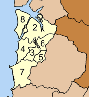
 The district Takua Pa is subdivided into 8 subdistricts (tambon
), which are further subdivided into 51 villages (muban
). Takua Pa itself has town (thesaban mueang) status and covers the complete tambon Takua Pa. There are 6 Tambon administrative organizations (TAO) - tambon Takua Pa is administrated by the town council, and Tam Tua by a neighboring TAO Bang Sai.
Amphoe
An amphoe is the second level administrative subdivision of Thailand. Usually translated as district, amphoe make up the provinces, and are analogous to a county seat...
) in the province Phang Nga
Phang Nga Province
Phang Nga is one of the southern provinces of Thailand, on the shore to the Andaman Sea. Neighboring provinces are Ranong, Surat Thani and Krabi. To the south is the Phuket province, but without land boundary to Phang Nga....
in the south of Thailand
Thailand
Thailand , officially the Kingdom of Thailand , formerly known as Siam , is a country located at the centre of the Indochina peninsula and Southeast Asia. It is bordered to the north by Burma and Laos, to the east by Laos and Cambodia, to the south by the Gulf of Thailand and Malaysia, and to the...
.
Geography
The district is located at the coast to the Andaman SeaAndaman Sea
The Andaman Sea or Burma Sea is a body of water to the southeast of the Bay of Bengal, south of Burma, west of Thailand and east of the Andaman Islands, India; it is part of the Indian Ocean....
. To the north of the district is the Si Phang-nga National Park
Si Phang-nga National Park
Si Phang-nga national park is located in Phang Nga Province in southern Thailand, covering the eastern parts of the district Khura Buri and Takua Pa....
. The southern part of the district is covered by the Khao Lak-Lam Ru National Park, which includes the popular beach resort of Khao Lak
Khao Lak
Khao Lak ) is a seaside resort located in the Takua Pa district in the Phang Nga province, Thailand and popular as a departure point for liveaboard scuba diving trips to the Similan Islands....
, devastated by the tsunami
Tsunami
A tsunami is a series of water waves caused by the displacement of a large volume of a body of water, typically an ocean or a large lake...
resulting from the 2004 Indian Ocean earthquake
2004 Indian Ocean earthquake
The 2004 Indian Ocean earthquake was an undersea megathrust earthquake that occurred at 00:58:53 UTC on Sunday, December 26, 2004, with an epicentre off the west coast of Sumatra, Indonesia. The quake itself is known by the scientific community as the Sumatra-Andaman earthquake...
.
Neighboring districts are Khura Buri
Amphoe Khura Buri
Khura Buri is a district in the province Phang Nga in the south of Thailand.-Geography:The district is located at the coast to the Andaman Sea as the northernmost district of Phang Nga Province...
to the north, Phanom
Amphoe Phanom
Phanom is a district in the southwest of Surat Thani Province of southern Thailand.-Geography:The district is located within the hills of the Phuket mountain range, with around 60% of the area consisting of mountains and forests. The northwestern part of the district is protected in the Khao Sok...
of Surat Thani Province
Surat Thani Province
Surat Thani is the largest of the southern provinces of Thailand, on the eastern shore of the Gulf of Thailand. Surat Thani means City of Good People, the title given to the city by King Vajiravudh ....
and Kapong
Amphoe Kapong
Kapong is a district in the province Phang Nga in the south of Thailand.-Geography:Neighboring districts are Phanom of Surat Thani Province, Mueang Phang Nga, Thai Mueang and Takua Pa....
to the east, and Thai Mueang
Amphoe Thai Mueang
Thai Mueang is a district in the province Phang Nga in the south of Thailand.-Geography:Neighboring districts are Takua Pa, Kapong, Mueang Phang Nga and Takua Thung. To the west is the Andaman Sea....
to the south.
History
Originally named Takola (Thai:ตะโกลา), the town was one of the historic city states (mueangMueang
Mueang were historical semi-independent city-states or principalities in present-day Thailand, Laos, parts of northern Vietnam and the Shan State of Myanmar. Smaller Mueang were subordinate to more powerful neighboring Mueang, which in turn were subordinate to the central king, as described in...
) dating back to Srivijaya
Srivijaya
Srivijaya was a powerful ancient thalassocratic Malay empire based on the island of Sumatra, modern day Indonesia, which influenced much of Southeast Asia. The earliest solid proof of its existence dates from the 7th century; a Chinese monk, I-Tsing, wrote that he visited Srivijaya in 671 for 6...
times in the 13th century. It was also known as Takkolam (Tamil
Tamil script
The Tamil script is a script that is used to write the Tamil language as well as other minority languages such as Badaga, Irulas, and Paniya...
: தக்கொலம்) which is the Tamil
Tamil language
Tamil is a Dravidian language spoken predominantly by Tamil people of the Indian subcontinent. It has official status in the Indian state of Tamil Nadu and in the Indian union territory of Pondicherry. Tamil is also an official language of Sri Lanka and Singapore...
word for “piper cuveba’ and “calyptranthes jambalana. There is also a place in the Tamil country
Ancient Tamil country
The Sangam period is the classical period in the history of Tamil Nadu, Kerala and other parts of South India, spanning about the 3rd century BCE to the 3rd century CE...
which up to now carries the same name Takkolam. Takuapa could have been either abounded by the spices “calyptranthese jambalana” and “piper cubeba” or it could have been occupied by settlers from the Takkolam of the Tamil country
Ancient Tamil country
The Sangam period is the classical period in the history of Tamil Nadu, Kerala and other parts of South India, spanning about the 3rd century BCE to the 3rd century CE...
, or both. Takuapa is said to have been the finest harbor on the west coast of the peninsula for trade between the Malay kingdom of Sri Vijaya and the early South India
South India
South India is the area encompassing India's states of Andhra Pradesh, Karnataka, Kerala and Tamil Nadu as well as the union territories of Lakshadweep and Pondicherry, occupying 19.31% of India's area...
n Tamil
Tamil people
Tamil people , also called Tamils or Tamilians, are an ethnic group native to Tamil Nadu, India and the north-eastern region of Sri Lanka. Historic and post 15th century emigrant communities are also found across the world, notably Malaysia, Singapore, Mauritius, South Africa, Australia, Canada,...
kingdoms of the Cholas and Pallavas during different times in history. It was later renamed to Takua Pa due to the rich ores near the town - Takua is the Thai word for lead
Lead
Lead is a main-group element in the carbon group with the symbol Pb and atomic number 82. Lead is a soft, malleable poor metal. It is also counted as one of the heavy metals. Metallic lead has a bluish-white color after being freshly cut, but it soon tarnishes to a dull grayish color when exposed...
, even though tin
Tin
Tin is a chemical element with the symbol Sn and atomic number 50. It is a main group metal in group 14 of the periodic table. Tin shows chemical similarity to both neighboring group 14 elements, germanium and lead and has two possible oxidation states, +2 and the slightly more stable +4...
was the most important ore found there.
There was a Hindu/Vishnu temple in the 8th century AD.
An important mercantile organisation called 'Kodumbalur Manigramam', built a water tank for this temple. They have left an inscription in Tamil. The tank was called 'Avani Naaranam' - 'Avani Naaranan' was the name of one of the Pallava Emperors of Tamil Nadu.
The town was long administrated by Nakhon Si Thammarat
Nakhon Si Thammarat kingdom
Nakhon Si Thammarat Kingdom was one of the major constituent city states of the Siamese kingdoms of Sukhothai and later Ayutthaya and controlled a big part of the Malay peninsula...
. In 1892 it was converted to a province, administered within the Monthon Phuket. This province was merged into Phang Nga province on April 1 1932. The district Talad Yai (big market, ตลาดใหญ่) was then renamed to Takua Pa.
The district was an important tin-dredging area in the first half of the twentieth century, with the English company Siamese Tin Syndicate Ltd., and the Australian company Satupulo No Liability Co. both operating dredges in the rivers, with narrow-gauge tramways following them upstream. The Asiatic Company also had a dredge and tramway further inland at Amphoe Kapong. Siamese Tin was operating here at least as late as 1967, but Thai magnates, such as the late Chuti Bunsung, took over operations by the early 1980s. By 2008 there was no sign left of the mining, as plantations, particularly rubber, have covered the former dredged areas. The public library at Takua Pa town has photographs on display of the dredging and sluicing operations in their heyday in the 1920s and 1930s. The former Asiatic Company workshops can also still be seen in Amphoe Kapong town.
The centre for the identification of bodies found after the 2004 tsunami is located in the district. Opposite the identification centre is the cemetery where all unidentified foreign bodies have been buried. Laid out somewhat like the Commonwealth War Graves cemetery at Kanchanaburi, in late 2008 the cemetery was overgrown and run down, and inhabited by wild dogs.
Administration
Tambon
Tambon is a local government unit in Thailand. Below district and province , they form the third administrative subdivision level. As of the 2009 there are 7255 tambon, not including the 169 khwaeng of Bangkok, which are set at the same administrative level, thus every district contains 8-10 tambon...
), which are further subdivided into 51 villages (muban
Muban
Muban is the lowest administrative subdivision of Thailand. Usually translated as village, they are the subdivision of tambon. As of 2008, there are 74944 administrative villages in Thailand. As of the 1990 census, the average village consisted of 144 households or 746 persons.A muban does not...
). Takua Pa itself has town (thesaban mueang) status and covers the complete tambon Takua Pa. There are 6 Tambon administrative organizations (TAO) - tambon Takua Pa is administrated by the town council, and Tam Tua by a neighboring TAO Bang Sai.
|
 |