
Amphoe Ban Ta Khun
Encyclopedia
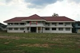
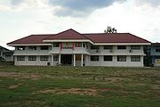
Ban Ta Khun is a district (Amphoe
) in the west of Surat Thani Province
of southern Thailand
. It is both the largest district of the province areawise as well as the one with the lowest population density
.
, with parts being protected within the Khao Sok
national park and the Khlong Saeng Wildlife Sanctuary
. Mostly located in Ranong province is the Khlong Nakha Wildlife Sanctuary
, which covers the northwestern corner of the district.
The main rivers of the district is the Khlong Saeng, which is dammed by the Ratchaprapha dam to form the Chiao Lan reservoir. It mouths near the town Khao Wong into the Phum Duang River
.
Neighboring districts are (from north clockwise) Tha Chang
, Vibhavadi
, Khiri Rat Nikhom
and Phanom
of Surat Thani, Khura Buri
of Phang Nga Province
, and Suk Samran and Kapoe
of Ranong Province
.
 The district was created on July 20, 1973 as a minor district (King Amphoe) by splitting off five tambon from Khiri Rat Nikhom.
On September 9, 1976 the minor district was elevated to full district status.
The fifth tambon Krai Son (ไกรสร) was later included into Khao Phang, as it was located in the area flooded by the Chiao Lan lake.
), which are further subdivided into 29 villages (muban
). There are two subdistrict municipalities (thesaban tambon) - Khao Wong (to be renamed Ban Ta Khun) covers 7.8 km² of tambon Khao Wong, and Khao Pang 10.1 km² of tambon Khao Pang. Each of the 4 tambon, except the areas covered by the municipalities, is administrated by a Tambon administrative organization (TAO).
Amphoe
An amphoe is the second level administrative subdivision of Thailand. Usually translated as district, amphoe make up the provinces, and are analogous to a county seat...
) in the west of Surat Thani Province
Surat Thani Province
Surat Thani is the largest of the southern provinces of Thailand, on the eastern shore of the Gulf of Thailand. Surat Thani means City of Good People, the title given to the city by King Vajiravudh ....
of southern Thailand
Thailand
Thailand , officially the Kingdom of Thailand , formerly known as Siam , is a country located at the centre of the Indochina peninsula and Southeast Asia. It is bordered to the north by Burma and Laos, to the east by Laos and Cambodia, to the south by the Gulf of Thailand and Malaysia, and to the...
. It is both the largest district of the province areawise as well as the one with the lowest population density
Population density
Population density is a measurement of population per unit area or unit volume. It is frequently applied to living organisms, and particularly to humans...
.
Geography
Most of the district is located within the hills of the Phuket mountain rangePhuket mountain range
The Phuket mountain range is a mountain range in the Kra Isthmus, Thailand.-Geography:This chain of hills is one of the southern sections of the central cordillera, the mountain chain which runs from Tibet through all of the Malay peninsula....
, with parts being protected within the Khao Sok
Khao Sok
Khao Sok national park is located in Surat Thani province in Thailand. Its land area is 739 km², and it includes the Chiao Lan reservoir dammed by the Ratchaprapha dam. The park comprises the largest area of virgin forest in Southern Thailand and is a remnant of rainforest which is older and more...
national park and the Khlong Saeng Wildlife Sanctuary
Khlong Saeng Wildlife Sanctuary
Khlong Saeng is a wildlife sanctuary in southern Thailand, located in the west of Surat Thani Province.It covers an area of 1155 km² of the districts Khiri Rat Nikhom and Ban Ta Khun, located directly north of the Khao Sok national park....
. Mostly located in Ranong province is the Khlong Nakha Wildlife Sanctuary
Khlong Nakha Wildlife Sanctuary
Khlong Nakha is a wildlife sanctuary in southern Thailand, located in the southeast of Ranong Province. It is located within the hills of the Phuket mountain range....
, which covers the northwestern corner of the district.
The main rivers of the district is the Khlong Saeng, which is dammed by the Ratchaprapha dam to form the Chiao Lan reservoir. It mouths near the town Khao Wong into the Phum Duang River
Phum Duang River
The Phum Duang River is a river in Surat Thani Province, Southern Thailand, the main tributary of the Tapi River....
.
Neighboring districts are (from north clockwise) Tha Chang
Amphoe Tha Chang, Surat Thani Province
Tha Chang is a district in the west of Surat Thani Province of southern Thailand.Neighboring districts are Chaiya to the north, the Bandon Bay to the east, Phunphin, Vibhavadi and Ban Ta Khun to the south, and to the west the district Kapoe of Ranong Province.-History:The minor district was...
, Vibhavadi
King Amphoe Vibhavadi
Vibhavadi is a district in the west of Surat Thani Province, southern Thailand.-Geography:Neighboring districts are Tha Chang, Phunphin, Khiri Rat Nikhom and Ban Ta Khun....
, Khiri Rat Nikhom
Amphoe Khiri Rat Nikhom
Khiri Rat Nikhom is a district in the west of Surat Thani Province of southern Thailand.- Geography :The western part of the district is located within the hills of the Phuket mountain range, while to the east the terrain is mostly flat...
and Phanom
Amphoe Phanom
Phanom is a district in the southwest of Surat Thani Province of southern Thailand.-Geography:The district is located within the hills of the Phuket mountain range, with around 60% of the area consisting of mountains and forests. The northwestern part of the district is protected in the Khao Sok...
of Surat Thani, Khura Buri
Amphoe Khura Buri
Khura Buri is a district in the province Phang Nga in the south of Thailand.-Geography:The district is located at the coast to the Andaman Sea as the northernmost district of Phang Nga Province...
of Phang Nga Province
Phang Nga Province
Phang Nga is one of the southern provinces of Thailand, on the shore to the Andaman Sea. Neighboring provinces are Ranong, Surat Thani and Krabi. To the south is the Phuket province, but without land boundary to Phang Nga....
, and Suk Samran and Kapoe
Amphoe Kapoe
Kapoe is a district of Ranong Province, southern Thailand.-Geography:Neighboring districts are Mueang Ranong of Ranong Province, Phato of Chumphon Province, Chaiya, Tha Chang and Ban Ta Khun of Surat Thani Province, and Suk Samran of Ranong again...
of Ranong Province
Ranong Province
Ranong is one of the southern provinces of Thailand, on the coast of the Andaman Sea. It is the province with the fewest citizens. Neighboring provinces are Chumphon, Surat Thani and Phang Nga...
.
History
On September 9, 1976 the minor district was elevated to full district status.
The fifth tambon Krai Son (ไกรสร) was later included into Khao Phang, as it was located in the area flooded by the Chiao Lan lake.
Symbols
The slogan of the district is High mountains, beautiful dam, rich in fruits, outstanding virtue, origin of the trunks for the city pillar.Administration
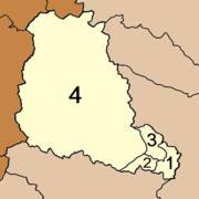
The district is subdivided into 4 subdistricts (tambonTambon
Tambon is a local government unit in Thailand. Below district and province , they form the third administrative subdivision level. As of the 2009 there are 7255 tambon, not including the 169 khwaeng of Bangkok, which are set at the same administrative level, thus every district contains 8-10 tambon...
), which are further subdivided into 29 villages (muban
Muban
Muban is the lowest administrative subdivision of Thailand. Usually translated as village, they are the subdivision of tambon. As of 2008, there are 74944 administrative villages in Thailand. As of the 1990 census, the average village consisted of 144 households or 746 persons.A muban does not...
). There are two subdistrict municipalities (thesaban tambon) - Khao Wong (to be renamed Ban Ta Khun) covers 7.8 km² of tambon Khao Wong, and Khao Pang 10.1 km² of tambon Khao Pang. Each of the 4 tambon, except the areas covered by the municipalities, is administrated by a Tambon administrative organization (TAO).
|
 |
External links
- amphoe.com
- Website of district (Archived 2009-10-25) (Thai)