
Amphoe Ban Na San
Encyclopedia
Ban Na San is a district (amphoe
) of Surat Thani Province
, Thailand
.
and Phipun
of Nakhon Si Thammarat Province
, Wiang Sa
, Khian Sa
, Ban Na Doem
, Mueang Surat Thani
and Kanchanadit
.
The east of the district is located within the hills of the Nakhon Si Thammarat mountain range
and is part of the Tai Rom Yen National Park
.
Originally the district was administrated from Nakhon Si Thammarat, and was transferred to Chaiya (now Surat Thani) in 1906.
On April 29 1918 the district was renamed to Ban Na, the location of the district office. On July 1 1938 the district office was moved to Na San and the district was renamed on April 20 1939 to Ban Na San. In the 1970s the district was reduced in size when the districts of Khian Sa, Wiang Sa and Ban Na Doem were split off.
), which are further subdivided into 65 villages (muban
). There is one town (thesaban mueang) Na San, which covers the complete tambon Na San. Each tambon except Na San has a Tambon administrative organization (TAO).
Amphoe
An amphoe is the second level administrative subdivision of Thailand. Usually translated as district, amphoe make up the provinces, and are analogous to a county seat...
) of Surat Thani Province
Surat Thani Province
Surat Thani is the largest of the southern provinces of Thailand, on the eastern shore of the Gulf of Thailand. Surat Thani means City of Good People, the title given to the city by King Vajiravudh ....
, Thailand
Thailand
Thailand , officially the Kingdom of Thailand , formerly known as Siam , is a country located at the centre of the Indochina peninsula and Southeast Asia. It is bordered to the north by Burma and Laos, to the east by Laos and Cambodia, to the south by the Gulf of Thailand and Malaysia, and to the...
.
Geography
Neighboring districts are (from the east clockwise) NopphitamAmphoe Nopphitam
Nopphitam is a district of Nakhon Si Thammarat Province, southern Thailand.-History:The district was created on April 1, 1995 by splitting off the four western tambon from Tha Sala district....
and Phipun
Amphoe Phipun
Phipun is a district in the northern part of Nakhon Si Thammarat Province, southern Thailand.-Geography:Neighboring districts are Nopphitam, Phrom Khiri, Lan Saka, Chawang of Nakhon Si Thammarat Province, Wiang Sa and Ban Na San of Surat Thani Province.-History:The minor district was created on...
of Nakhon Si Thammarat Province
Nakhon Si Thammarat Province
Nakhon Si Thammarat is one of the southern provinces of Thailand, at the eastern shore of the Gulf of Thailand...
, Wiang Sa
Amphoe Wiang Sa, Surat Thani Province
-Geography:Wiang Sa is located in the southeast of Surat Thani province. Neighboring district are Phrasaeng, Khian Sa and Ban Na San of Surat Thani, and Phipun, Chawang and Tham Phannara of Nakhon Si Thammarat Province....
, Khian Sa
Amphoe Khian Sa
Khian Sa is a district in Surat Thani Province, Thailand.Neighboring districts are Khiri Rat Nikhom, Phunphin, Ban Na Doem, Ban Na San, Wiang Sa, Phrasaeng and Phanom...
, Ban Na Doem
Amphoe Ban Na Doem
-Geography:Ban Na Doem is located in the center of Surat Thani province. Neighboring district are Mueang Surat Thani, Ban Na San, Khian Sa and Phunphin.The Tapi River forms part of the western boundary of the district...
, Mueang Surat Thani
Amphoe Mueang Surat Thani
Mueang Surat Thani is the capital district of Surat Thani Province in southern Thailand.-Geography:The district is located at the mouth of the Tapi River into the Bandon Bay of the Gulf of Thailand...
and Kanchanadit
Amphoe Kanchanadit
Kanchanadit is a district in the province Surat Thani in the south of Thailand.-History:Originally the town was named Thathong and was located at the shore of Khlong Thathong Mai . During the reign of King Nangklao the town was moved because its location was malaria-infested, and renamed to...
.
The east of the district is located within the hills of the Nakhon Si Thammarat mountain range
Nakhon Si Thammarat mountain range
The Nakhon Si Thammarat mountain range is a mountain range on the Malay peninsula in southern Thailand, running in a north-south direction. This mountain chain is also sometimes named Banthat mountain range , a name which is however also used to refer to the Chanthaburi mountain...
and is part of the Tai Rom Yen National Park
Tai Rom Yen National Park
The Tai Rom Yen National Park is located in the east of the Surat Thani Province in Southern Thailand. The park consists of the northern end of the Nakhon Si Thammarat mountain range and is mostly covered with forests...
.
History
The district dates back to the Lamphun district, once responsible for all of the southeastern part of the present-day province. Originally the district was subdivided into 7 tambon - Ban Na, Tha Ruea, Kobkaeb, Thung Tao, I-Pan, Prasaeng and Phanom. In 1899 the southern part was split of as Prasaeng district and Phanom minor district.Originally the district was administrated from Nakhon Si Thammarat, and was transferred to Chaiya (now Surat Thani) in 1906.
On April 29 1918 the district was renamed to Ban Na, the location of the district office. On July 1 1938 the district office was moved to Na San and the district was renamed on April 20 1939 to Ban Na San. In the 1970s the district was reduced in size when the districts of Khian Sa, Wiang Sa and Ban Na Doem were split off.
Administration
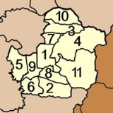
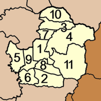
Ban Na San is subdivided into 11 subdistricts (tambonTambon
Tambon is a local government unit in Thailand. Below district and province , they form the third administrative subdivision level. As of the 2009 there are 7255 tambon, not including the 169 khwaeng of Bangkok, which are set at the same administrative level, thus every district contains 8-10 tambon...
), which are further subdivided into 65 villages (muban
Muban
Muban is the lowest administrative subdivision of Thailand. Usually translated as village, they are the subdivision of tambon. As of 2008, there are 74944 administrative villages in Thailand. As of the 1990 census, the average village consisted of 144 households or 746 persons.A muban does not...
). There is one town (thesaban mueang) Na San, which covers the complete tambon Na San. Each tambon except Na San has a Tambon administrative organization (TAO).
|
 |
External links
- amphoe.com (Thai)
- http://www.nasancity.org (Thai)