

Thailand Route 44
Encyclopedia
Route 44 is part of land bridge project. It starts at intersection with Route 4
in Krabi Province
, running northeast, and ends at intersection with Route 401
in Surat Thani Province
.
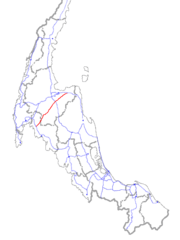 Route 44 is part of land bridge project of Thailand's southern seaboard. However, the other parts of project have not yet built. Route 44 was slated to connect seaports on both the western and eastern coasts of Thailand. However, as the locations of seaports have not yet been finalized, only the central portion of Route 44 has been constructed. The roughly 50 km missing portions will be built when the location of the seaports has been finalized.
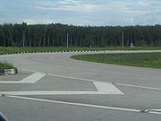
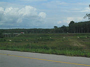 Route 44 is unique in that it was designed to accompany other forms of transportation. Both directions of the road were built 150 meter apart. The large center median will be used for a railroad tracks and a pipeline. However, the project is currently stalled and nothing has been built but the roadways, leaving the center of the highway empty. There are also no crossing intersections, the only way to cross the highway is to use the U-turns or one of the few bridges.
 In Krabi Province, it starts at Amphoe Ao Luek
and passes through Plai Phraya. It enters Surat Thani Province at Amphoe Phrasaeng
and passes through Amphoe Khian Sa
, Amphoe Ban Na Doem
, Amphoe Mueang Surat Thani
and ends at Amphoe Kanchanadit
.
Total length is about 190 km. About 40 km is in Krabi Province and 150 km in Surat Thani Province. Route 44 is asphalt for entire length and has 4 lanes total, 2 lane for each direction with 150 meter ditch to separate the directions.
Phetkasem highway
Phetkasem Road or Thailand Route 4 is one of the four major highways in Thailand, along with Phahonyothin Road , Mittraphap Road , and Sukhumvit Road . At 1,274 km, it is the longest highway in Thailand. It begins at Naowa Chamnian bridge in Bangkok Yai, Bangkok...
in Krabi Province
Krabi Province
Krabi is one of the southern provinces of Thailand, at the shore of the Andaman Sea. Neighbouring provinces are Phang Nga, Surat Thani, Nakhon Si Thammarat and Trang. The Phuket province to the west is also neighbouring, but without any land boundary...
, running northeast, and ends at intersection with Route 401
Thailand Route 401
Thailand Route 401 is a highway in southern Thailand. It starts from the west coast of the Thai-Malay Peninsula at an intersection with Route 4 near Amphoe Takua Pa, Phang Nga Province....
in Surat Thani Province
Surat Thani Province
Surat Thani is the largest of the southern provinces of Thailand, on the eastern shore of the Gulf of Thailand. Surat Thani means City of Good People, the title given to the city by King Vajiravudh ....
.
Route Details
Amphoe Ao Luek
Ao Luek is a district in Krabi Province, Thailand.-Geography:Neighboring districts are Plai Phraya, Khao Phanom, Mueang Krabi...
and passes through Plai Phraya. It enters Surat Thani Province at Amphoe Phrasaeng
Amphoe Phrasaeng
-Geography:The district is located in the south of the province. Neighboring districts are Phanom, Khian Sa, Wiang Sa of Surat Thani Province, Tham Phannara, Thung Yai of Nakhon Si Thammarat Province, Chai Buri of Surat Thani Province again, Khao Phanom and Plai Phraya of Krabi Province.At the...
and passes through Amphoe Khian Sa
Amphoe Khian Sa
Khian Sa is a district in Surat Thani Province, Thailand.Neighboring districts are Khiri Rat Nikhom, Phunphin, Ban Na Doem, Ban Na San, Wiang Sa, Phrasaeng and Phanom...
, Amphoe Ban Na Doem
Amphoe Ban Na Doem
-Geography:Ban Na Doem is located in the center of Surat Thani province. Neighboring district are Mueang Surat Thani, Ban Na San, Khian Sa and Phunphin.The Tapi River forms part of the western boundary of the district...
, Amphoe Mueang Surat Thani
Amphoe Mueang Surat Thani
Mueang Surat Thani is the capital district of Surat Thani Province in southern Thailand.-Geography:The district is located at the mouth of the Tapi River into the Bandon Bay of the Gulf of Thailand...
and ends at Amphoe Kanchanadit
Amphoe Kanchanadit
Kanchanadit is a district in the province Surat Thani in the south of Thailand.-History:Originally the town was named Thathong and was located at the shore of Khlong Thathong Mai . During the reign of King Nangklao the town was moved because its location was malaria-infested, and renamed to...
.
Total length is about 190 km. About 40 km is in Krabi Province and 150 km in Surat Thani Province. Route 44 is asphalt for entire length and has 4 lanes total, 2 lane for each direction with 150 meter ditch to separate the directions.
List of Intersection
- Krabi Province
- (Start) Route 4Phetkasem highwayPhetkasem Road or Thailand Route 4 is one of the four major highways in Thailand, along with Phahonyothin Road , Mittraphap Road , and Sukhumvit Road . At 1,274 km, it is the longest highway in Thailand. It begins at Naowa Chamnian bridge in Bangkok Yai, Bangkok...
(northwestward to Phang Nga ProvincePhang Nga ProvincePhang Nga is one of the southern provinces of Thailand, on the shore to the Andaman Sea. Neighboring provinces are Ranong, Surat Thani and Krabi. To the south is the Phuket province, but without land boundary to Phang Nga....
, southeastward to Amphoe Mueang KrabiAmphoe Mueang KrabiKrabi is the capital district of Krabi Province in southern Thailand.-Geography:Neighboring districts are Ao Luek, Khao Phanom and Nuea Khlong. To the south and west borders the Phang Nga Bay....
) - Route 4035 (westward to Amphoe Plai PhrayaAmphoe Plai Phraya-Geography:Neighboring districts are Phanom, Phrasaeng, Chai Buri , Khao Phanom and Ao Luek of Krabi Province, and Thap Put of Phang Nga Province....
, eastward to Amphoe PhrasaengAmphoe Phrasaeng-Geography:The district is located in the south of the province. Neighboring districts are Phanom, Khian Sa, Wiang Sa of Surat Thani Province, Tham Phannara, Thung Yai of Nakhon Si Thammarat Province, Chai Buri of Surat Thani Province again, Khao Phanom and Plai Phraya of Krabi Province.At the...
)
- (Start) Route 4
- Surat Thani Province
- Route 4113 (northward to Amphoe Phunphin, southward to Amphoe Phrasaeng)
- Route 41Thailand Route 41Route 41 starts at intersection with Route 4 in Chumphon Province. It goes southward passing through Surat Thani Province and Nakhon Si Thammarat Province. It ends at Phatthalung Province joining Route 4 again.-Route Details:...
(northward to Amphoe Phunphin, southward to Amphoe Ban Na DoemAmphoe Ban Na Doem-Geography:Ban Na Doem is located in the center of Surat Thani province. Neighboring district are Mueang Surat Thani, Ban Na San, Khian Sa and Phunphin.The Tapi River forms part of the western boundary of the district...
(Interchange*)) - Route 4009 (northward to Amphoe Mueang Surat ThaniAmphoe Mueang Surat ThaniMueang Surat Thani is the capital district of Surat Thani Province in southern Thailand.-Geography:The district is located at the mouth of the Tapi River into the Bandon Bay of the Gulf of Thailand...
, southward to Amphoe Ban Na SanAmphoe Ban Na San-Geography:Neighboring districts are Nopphitam and Phipun of Nakhon Si Thammarat Province, Wiang Sa, Khian Sa, Ban Na Doem, Mueang Surat Thani and Kanchanadit....
) - (end) Route 401Thailand Route 401Thailand Route 401 is a highway in southern Thailand. It starts from the west coast of the Thai-Malay Peninsula at an intersection with Route 4 near Amphoe Takua Pa, Phang Nga Province....
(westward to Amphoe KanchanaditAmphoe KanchanaditKanchanadit is a district in the province Surat Thani in the south of Thailand.-History:Originally the town was named Thathong and was located at the shore of Khlong Thathong Mai . During the reign of King Nangklao the town was moved because its location was malaria-infested, and renamed to...
, eastward to Nakhon Si Thammarat ProvinceNakhon Si Thammarat ProvinceNakhon Si Thammarat is one of the southern provinces of Thailand, at the eastern shore of the Gulf of Thailand...
)