

Aegean dispute
Encyclopedia
 |
 |
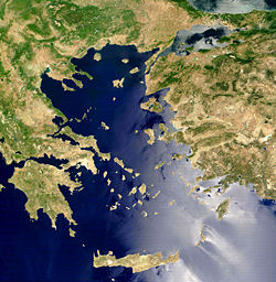
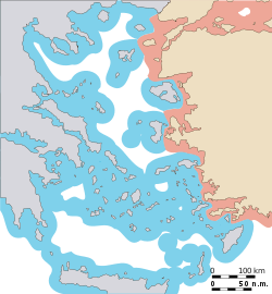
| Territorial waters and air space approximate extent: |
|---|
 |
 |
 |
The Aegean dispute is a set of interrelated controversial issues between Greece
Greece
Greece , officially the Hellenic Republic , and historically Hellas or the Republic of Greece in English, is a country in southeastern Europe....
and Turkey
Turkey
Turkey , known officially as the Republic of Turkey , is a Eurasian country located in Western Asia and in East Thrace in Southeastern Europe...
over sovereignty and related rights in the area of the Aegean Sea
Aegean Sea
The Aegean Sea[p] is an elongated embayment of the Mediterranean Sea located between the southern Balkan and Anatolian peninsulas, i.e., between the mainlands of Greece and Turkey. In the north, it is connected to the Marmara Sea and Black Sea by the Dardanelles and Bosporus...
. This set of conflicts has had a large effect on Greek-Turkish relations since the 1970s. It has twice led to crises coming close to the outbreak of military hostilities, in 1987 and in early 1996. The issues in the Aegean fall into several categories:
- The delimitationBoundary delimitationBoundary delimitation, or simply delimitation, is the term used to describe the drawing of boundaries, but is most often used to describe the drawing of electoral boundaries, specifically those of precincts, states, counties or other municipalities...
of the territorial watersTerritorial watersTerritorial waters, or a territorial sea, as defined by the 1982 United Nations Convention on the Law of the Sea, is a belt of coastal waters extending at most from the baseline of a coastal state...
, - The delimitation of the national airspace,
- The delimitation of exclusive economic zoneExclusive Economic ZoneUnder the law of the sea, an exclusive economic zone is a seazone over which a state has special rights over the exploration and use of marine resources, including production of energy from water and wind. It stretches from the seaward edge of the state's territorial sea out to 200 nautical...
s and the use of the continental shelfContinental shelfThe continental shelf is the extended perimeter of each continent and associated coastal plain. Much of the shelf was exposed during glacial periods, but is now submerged under relatively shallow seas and gulfs, and was similarly submerged during other interglacial periods. The continental margin,...
, - The delimitation of Flight Information Regions (FIR)Flight Information RegionIn aviation a flight information region is a region of airspace with specific dimensions, in which a flight information service and an alerting service are provided. It is the largest regular division of airspace in use in the world today....
, and their significance for the control of military flight activity, - The issue of the demilitarized status assigned to some of the Greek islands in the area,
- Turkish claims of "grey zones" of undetermined sovereignty over a number of small islets, most notably the islets of Imia/KardakImia/KardakImia is a pair of two small uninhabited islets in the Aegean Sea, situated between the Greek island chain of the Dodecanese and the southwestern mainland coast of Turkey. They lie west of the coast of Muğla Province, east of the Greek island Kalymnos, and southeast of the nearest small Greek...
.
Since 1998, the two countries have been coming closer to overcome the tensions through a series of diplomatic measures, particularly with a view to easing Turkey's accession to the
Accession of Turkey to the European Union
Turkey's application to accede to the European Union was made on 14 April 1987. Turkey has been an associate member of the European Union and its predecessors since 1963...
European Union
European Union
The European Union is an economic and political union of 27 independent member states which are located primarily in Europe. The EU traces its origins from the European Coal and Steel Community and the European Economic Community , formed by six countries in 1958...
. However, as of 2010, differences over suitable diplomatic paths to a substantial solution are still unresolved.
See also: Foreign relations of Turkey
Foreign relations of Turkey
Foreign relations of the Republic of Turkey are the Turkish government's policies in its external relations with the international community...
, Foreign relations of Greece
Foreign relations of Greece
Prominent issues in Greek foreign policy include the enduring dispute over Cyprus and differences with Turkey over the Aegean, the dispute over the name of the Republic of Macedonia , and relations with the United States.-Overview:Greece has diplomatic relations with almost all the...
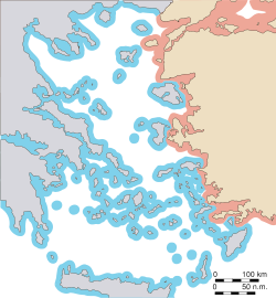
Maritime and areal zones of influence
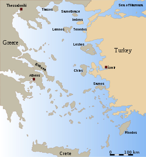
Several of the Aegean issues deal with the delimitation of both countries' zones of influence in the air and on the sea around their respective territories. These issues owe their virulence to a geographical peculiarity of the Aegean sea and its territories. While the mainland coasts of Greece and Turkey bordering the Aegean Sea on both sides represent roughly equal shares of its total coastline, the overwhelming number of the many Aegean islandsAegean Islands
The Aegean Islands are the group of islands in the Aegean Sea, with mainland Greece to the west and north and Turkey to the east; the island of Crete delimits the sea to the south, those of Rhodes, Karpathos and Kasos to the southeast...
belong to Greece. In particular, there is a chain of Greek islands lined up along the Turkish west coast (Lesbos
Lesbos Island
Lesbos is a Greek island located in the northeastern Aegean Sea. It has an area of with 320 kilometres of coastline, making it the third largest Greek island. It is separated from Turkey by the narrow Mytilini Strait....
, Chios
Chios
Chios is the fifth largest of the Greek islands, situated in the Aegean Sea, seven kilometres off the Asia Minor coast. The island is separated from Turkey by the Chios Strait. The island is noted for its strong merchant shipping community, its unique mastic gum and its medieval villages...
, Samos
Samos Island
Samos is a Greek island in the eastern Aegean Sea, south of Chios, north of Patmos and the Dodecanese, and off the coast of Asia Minor, from which it is separated by the -wide Mycale Strait. It is also a separate regional unit of the North Aegean region, and the only municipality of the regional...
, and the Dodecanese islands), partly in very close proximity to the mainland. Their existence blocks Turkey from extending any of its zones of influence beyond a few nautical miles off its coastline. As the breadth of maritime and areal zones of influence, such as the territorial waters and national airspace, are measured from the nearest territory of the state in question, including its islands, any possible extension of such zones would necessarily benefit Greece much more than Turkey proportionally.
According to a popular perception of these issues in the two countries, Turkey is concerned that Greece might be trying to extend its zones of influence to such a degree that it would turn the Aegean effectively into a "Greek lake". Conversely, Greece is concerned that Turkey might try to "occupy half of the Aegean", i.e. establish Turkish zones of influence towards the middle of the Aegean, beyond the chain of outlying Greek islands, turning these into a kind of exclave surrounded by Turkish waters, and thus cutting them off from their motherland.
The territorial waters
Territorial waters give the littoral state full control over air navigation in the airspace above, and partial control over shipping, although foreign ships (both civil and military) are normally guaranteed innocent passageInnocent passage
Innocent passage is a concept in admiralty law which allows for a vessel to pass through the territorial waters of another state subject to certain restrictions. The UN Convention on the Law of the Sea defines innocent passage as:...
through them. The standard width of territorial waters that countries are customarily entitled to has steadily increased in the course of the 20th century: from initially 3 nautical miles (5.6 km) at the beginning of the century, to 6 nautical miles (11.1 km), and currently 12 nautical miles (22.2 km). The current value has been enshrined in treaty law by the United Nations Convention on the Law of the Sea
United Nations Convention on the Law of the Sea
The United Nations Convention on the Law of the Sea , also called the Law of the Sea Convention or the Law of the Sea treaty, is the international agreement that resulted from the third United Nations Conference on the Law of the Sea , which took place from 1973 through 1982...
of 1982 (Art.3). In the Aegean the territorial waters claimed by both sides are still at 6 miles. The possibility of an extension to 12 miles has fuelled Turkish concerns over a possible disproportionate increase in Greek-controlled space. Turkey has refused to become a member of the convention and does not consider itself bound by it. Turkey considers the convention as res inter alios acta
Res inter alios acta
Res inter alios acta, aliis nec nocet nec prodest is a law doctrine which holds that a contract cannot adversely affect the rights of one who is not a party to the contract....
, i.e. a treaty that can only be binding to the signing parties but not to others. Greece, which is a party to the convention, has stated that it reserves the right to apply this rule and extend its waters to 12 miles at some point in the future, although it has never actually attempted to do so. It holds that the 12 mile rule is not only treaty law but also customary law, as per the wide consensus established among the international community. Against this, Turkey argues that the special geographical properties of the Aegean Sea make a strict application of the 12 mile rule in this case illicit in the interest of equity. Turkey has itself applied the customary 12 mile limit to its coasts outside the Aegean.
Tensions over the 12 mile question ran highest between the two countries in the early 1990s, when the Law of the Sea was going to come into force. On 9 June 1995, the Turkish parliament officially declared that unilateral action by Greece would constitute a casus belli
Casus belli
is a Latin expression meaning the justification for acts of war. means "incident", "rupture" or indeed "case", while means bellic...
, i.e. reason to go to war. This declaration has been condemned by Greece as a violation of the Charter of the United Nations, which forbids "the threat or use of force against the territorial integrity or political independence of any state".
The national airspace
The national airspace is normally defined as the airspace covering a state's land territory and its adjacent territorial waters. National airspace gives the sovereign state a large degree of control over foreign air traffic. While civil aviation is normally allowed passage under international treaties, foreign military and other state aircraft (unlike military vessels in the territorial waters) do not have a right to free passage through another state's national airspace. The delimitation of national airspace claimed by Greece is exceptional, as it does not coincide with the boundary of the territorial waters. Greece claims 10 nautical miles (18.5 km) of airspace, as opposed to currently 6 miles of territorial waters. Since 1974, Turkey has refused to acknowledge the validity of the outer 4-mile belt of airspace that extends beyond the Greek territorial waters. Turkey cites the statutes of the International Civil Aviation OrganizationInternational Civil Aviation Organization
The International Civil Aviation Organization , pronounced , , is a specialized agency of the United Nations. It codifies the principles and techniques of international air navigation and fosters the planning and development of international air transport to ensure safe and orderly growth...
(ICAO) of 1948, as containing a binding definition that both zones must coincide. Against this, Greece argues that:
- its 10 nautical miles (18.5 km) claim predates the ICAO statute, having been fixed in 1931, and that it was acknowledged by all its neighbours, including Turkey, before and after 1948, hence constituting an established right;
- its 10 mile claim can also be interpreted as just a partial, selective use of the much wider rights guaranteed by the Law of the Sea, namely the right to a 12 mile zone both in the air and on the water;
- Greek territorial waters are set at the 6 mile boundary only because of Turkey's casus belliCasus belliis a Latin expression meaning the justification for acts of war. means "incident", "rupture" or indeed "case", while means bellic...
(see above).
The conflict over military flight activities has led to a practice of continuous tactical military provocations, with Turkish aircraft flying in the outer 4 mile zone of contentious airspace and Greek aircraft intercepting them. These encounters often lead to so-called "dog-fights", dangerous flight maneuvers that have repeatedly ended in casualties on both sides. In one instance in 1996, it has been alleged that a Turkish plane was accidentally shot down by a Greek one.
The continental shelf
In the context of the Aegean dispute, the term continental shelfContinental shelf
The continental shelf is the extended perimeter of each continent and associated coastal plain. Much of the shelf was exposed during glacial periods, but is now submerged under relatively shallow seas and gulfs, and was similarly submerged during other interglacial periods. The continental margin,...
refers to a littoral state's exclusive right to economic exploitation of resources on and under the sea-bed, for instance oil drilling
Petroleum
Petroleum or crude oil is a naturally occurring, flammable liquid consisting of a complex mixture of hydrocarbons of various molecular weights and other liquid organic compounds, that are found in geologic formations beneath the Earth's surface. Petroleum is recovered mostly through oil drilling...
, in an area adjacent to its territorial waters
Territorial waters
Territorial waters, or a territorial sea, as defined by the 1982 United Nations Convention on the Law of the Sea, is a belt of coastal waters extending at most from the baseline of a coastal state...
and extending into the High Seas. The width of the continental shelf is commonly defined for purposes of international law as not exceeding 200 nautical miles. Where the territories of two states lie closer opposite each other than double that distance, the division is made by the median line.
The concept of the continental shelf is closely connected to that of an exclusive economic zone
Exclusive Economic Zone
Under the law of the sea, an exclusive economic zone is a seazone over which a state has special rights over the exploration and use of marine resources, including production of energy from water and wind. It stretches from the seaward edge of the state's territorial sea out to 200 nautical...
, which refers to a littoral state's control over fishery
Fishery
Generally, a fishery is an entity engaged in raising or harvesting fish which is determined by some authority to be a fishery. According to the FAO, a fishery is typically defined in terms of the "people involved, species or type of fish, area of water or seabed, method of fishing, class of boats,...
and similar rights. Both concepts were developed in international law from the middle of the 20th century, and were codified in the United Nations Convention on the Law of the Sea
United Nations Convention on the Law of the Sea
The United Nations Convention on the Law of the Sea , also called the Law of the Sea Convention or the Law of the Sea treaty, is the international agreement that resulted from the third United Nations Conference on the Law of the Sea , which took place from 1973 through 1982...
in 1982.
The dispute between Turkey and Greece is to what degree the Greek islands off the Turkish coast should be taken into account for determining the Greek and Turkish economic zones. Turkey argues that the notion of "continental shelf", by its very definition, implies that distances should be measured from the continental mainland, claiming that the sea-bed of the Aegean geographically forms a natural prolongation
Natural prolongation
The natural prolongation principle or principle of natural prolongation is a legal concept introduced in maritime claims submitted to the United Nations....
of the Anatolia
Anatolia
Anatolia is a geographic and historical term denoting the westernmost protrusion of Asia, comprising the majority of the Republic of Turkey...
n land mass. This would mean for Turkey to be entitled to economic zones up to the median line of the Aegean (leaving out, of course, the territorial waters around the Greek islands in its eastern half, which would remain as Greek exclaves.) Greece, on the other hand, claims that all islands must be taken into account on an equal basis. This would mean that Greece would gain the economic rights to almost the whole of the Aegean.
In this matter, Greece has the UN Law of the Sea on its side, although the Convention restricts the application of this rule to islands of a notable size, as opposed to small uninhabitable islets and rocks. The precise delimitation of the economic zones is the only one of all the Aegean issues where Greece has officially acknowledged that Turkey has legitimate interests that might require some international process of arbitration or compromise between the two sides.
Tensions over the continental shelf were particularly high during the mid-1970s and again the late 1980s, when it was believed that the Aegean Sea might hold rich oil reserves
Oil reserves
The total estimated amount of oil in an oil reservoir, including both producible and non-producible oil, is called oil in place. However, because of reservoir characteristics and limitations in petroleum extraction technologies, only a fraction of this oil can be brought to the surface, and it is...
. Turkey at that time conducted exploratory oceanographic
Oceanography
Oceanography , also called oceanology or marine science, is the branch of Earth science that studies the ocean...
research missions in parts of the disputed area. These were perceived as a dangerous provocation by Greece, which led to a buildup of mutual military threats in 1976 and again in 1987.
The Flight Information Regions
Unlike the issues described so far, the question of Flight Information Regions (FIR)Flight Information Region
In aviation a flight information region is a region of airspace with specific dimensions, in which a flight information service and an alerting service are provided. It is the largest regular division of airspace in use in the world today....
does not affect the two states' sovereignty rights in the narrow sense. A FIR is a zone of responsibility assigned to a state within the framework of the International Civil Aviation Organization (ICAO)
International Civil Aviation Organization
The International Civil Aviation Organization , pronounced , , is a specialized agency of the United Nations. It codifies the principles and techniques of international air navigation and fosters the planning and development of international air transport to ensure safe and orderly growth...
. It relates to the responsibility for regulating civil aviation. A FIR may stretch beyond the national airspace of a country, i.e. over areas of high seas, or in some cases even over the airspace of another country. It does not give the responsible state the right to prohibit flights by foreign aircraft; however, foreign aircraft are obliged to submit flight plans to the authorities administrating the FIR. Two separate disputes have arisen over flight control in the Aegean: the issue of a unilaterally proposed revision of the FIR demarcation, and the question of what rights and obligations arise from the FIR with respect to military as opposed to civil flights.
The FIR demarcation
By virtue of an agreement signed in 1952, the whole airspace over the Aegean, up to the boundary of the national airspace of Turkey, has been assigned to Athens FIR, administered by Greece. Shortly after the Cyprus crisisCyprus dispute
The Cyprus dispute is the result of the ongoing conflict between the Republic of Cyprus and Turkey, over the Turkish occupied northern part of Cyprus....
of 1974, Turkey unilaterally attempted to change this arrangement, issuing a Notice to Airmen (NOTAM) stating that it would take over the administration of the eastern half of the Aegean airspace, including the national airspace of the Greek islands in that area. Greece responded with a declaration rejecting this move, and declaring the disputed zone unsafe for aviation due to the conflicting claims to authority. This led to some disruption in civil aviation in the area. Turkey later changed its stance, and since 1980 has returned to recognizing Athens FIR in its original demarcation. In practice, the FIR demarcation is currently no longer a disputed issue.
Turkish Military overflights
The current (as of 2009) controversy over the FIR relates to the question whether the Greek authorities have a right to oversee not only civil but also military flight activities in the international parts of the Aegean airspace. According to common international practice, military aircraft normally submit flight plans to FIR authorities when moving in international airspace, just like civil aircraft do. Turkey refuses to do so, citing the ICAO charter of 1948, which explicitly restricts the scope of its regulations to civil aircraft, arguing that therefore the practice of including military aircraft in the same system is optional. Greece, in contrast, argues that it is obligatory on the basis of later regulations of the ICAO, which it claims have given states the authority to issue more wide-reaching restrictions in the interest of civil aviation safety.This disagreement has led to similar practical consequences as the issue of 6 versus 10 miles of national airspace, as Greece considers all Turkish military flights not registered with its FIR authorities as transgressions of international air traffic regulations, and routinely has its own air force jets intercepting the Turkish ones. In popular perception in Greece, the issue of Turkish flights in the international part of Athens FIR is often confused with that of the Turkish intrusions in the disputed outer 4 mile belt of Greek airspace. However, in careful official usage, Greek authorities and media distinguish between "violations" ("παραβιάσεις") of the national airspace, and "transgressions" ("παραβάσεις") of traffic regulations, i.e. of the FIR.
One of the routine interception maneuvers led to a fatal accident on 23 May 2006. Two Turkish F-16s and one reconnaissance F-4
F-4 Phantom II
The McDonnell Douglas F-4 Phantom II is a tandem two-seat, twin-engined, all-weather, long-range supersonic jet interceptor fighter/fighter-bomber originally developed for the United States Navy by McDonnell Aircraft. It first entered service in 1960 with the U.S. Navy. Proving highly adaptable,...
were flying in the international airspace over the southern Aegean at 27000 feet (8,229.6 m) without having submitted flight plans to the Greek FIR authorities. They were intercepted by two Greek F-16s off the coast of the Greek island Karpathos
Karpathos
Karpathos is the second largest of the Greek Dodecanese islands, in the southeastern Aegean Sea. Together with the neighboring smaller Saria Island it forms the municipality Karpathos, which is part of the Karpathos peripheral unit. From its remote position Karpathos has preserved many...
. During the ensuing mock dog fight, a Turkish F-16 and a Greek F-16 crashed midair. The pilot of the Turkish plane survived the crash, but the Greek pilot died. The incident also highlighted another aspect of the FIR issue, a dispute over conflicting claims to responsibility for maritime search and rescue
Search and rescue
Search and rescue is the search for and provision of aid to people who are in distress or imminent danger.The general field of search and rescue includes many specialty sub-fields, mostly based upon terrain considerations...
operations. The Turkish pilot reportedly refused to be rescued by the Greek forces that had been dispatched to the area. After the incident, both governments expressed an interest to revive an earlier plan of establishing a direct hotline between the air force commands of both countries in order to prevent escalation of similar situations in the future.
The islands
 |
 |
While all the issues described so far are related to zones of influence at sea or in the air, there have also been a number of disputes related to the territories of the Greek islands themselves. These have related to the demilitarized status of some of the main islands in the area; to Turkish concerns over alleged endeavours by Greece to artificially expand settlements to previously uninhabited islets; and to the existence of alleged "grey zones", an undetermined number of small islands of undetermined sovereignty.
Demilitarized status
The question of the demilitarized status of some major Greek islands is complicated by a number of facts. Several of the Greek islands in the eastern Aegean as well as the Turkish straits region were placed under various regimes of demilitarization in different international treaties. The regimes developed over time, resulting in difficulties of treaty-interpretation. The military status of the islands in question did however not constitute a serious problem in the bilateral relations until the Cyprus crisisCyprus dispute
The Cyprus dispute is the result of the ongoing conflict between the Republic of Cyprus and Turkey, over the Turkish occupied northern part of Cyprus....
of 1974, after which both Greece and Turkey re-interpreted the stipulations of the treaties. Greece, claiming an inalienable right to defend itself against Turkish aggression, reinforced its military and National Guard forces in the region. Turkey, on the other hand, denounces this as an aggressive act by Greece and as a breach of international treaties. From a legal perspective, three groups of islands may be distinguished: (a) the islands right off the Turkish Dardanelles
Dardanelles
The Dardanelles , formerly known as the Hellespont, is a narrow strait in northwestern Turkey connecting the Aegean Sea to the Sea of Marmara. It is one of the Turkish Straits, along with its counterpart the Bosphorus. It is located at approximately...
straits, i.e. Lemnos
Lemnos
Lemnos is an island of Greece in the northern part of the Aegean Sea. Administratively the island forms a separate municipality within the Lemnos peripheral unit, which is part of the North Aegean Periphery. The principal town of the island and seat of the municipality is Myrina...
and Samothrace
Samothrace
Samothrace is a Greek island in the northern Aegean Sea. It is a self-governing municipality within the Evros peripheral unit of Thrace. The island is long and is in size and has a population of 2,723 . Its main industries are fishing and tourism. Resources on the island includes granite and...
; (b) the Dodecanese
Dodecanese
The Dodecanese are a group of 12 larger plus 150 smaller Greek islands in the Aegean Sea, of which 26 are inhabited. Τhis island group generally defines the eastern limit of the Sea of Crete. They belong to the Southern Sporades island group...
islands in the southeast Aegean; and (c) the remaining northeast Aegean islands (Lesbos
Lesbos Island
Lesbos is a Greek island located in the northeastern Aegean Sea. It has an area of with 320 kilometres of coastline, making it the third largest Greek island. It is separated from Turkey by the narrow Mytilini Strait....
, Chios
Chios
Chios is the fifth largest of the Greek islands, situated in the Aegean Sea, seven kilometres off the Asia Minor coast. The island is separated from Turkey by the Chios Strait. The island is noted for its strong merchant shipping community, its unique mastic gum and its medieval villages...
, Samos
Samos Island
Samos is a Greek island in the eastern Aegean Sea, south of Chios, north of Patmos and the Dodecanese, and off the coast of Asia Minor, from which it is separated by the -wide Mycale Strait. It is also a separate regional unit of the North Aegean region, and the only municipality of the regional...
, and Ikaria).
Lemnos and Samothrace
These islands were placed under a demilitarization statute by the Treaty of LausanneTreaty of Lausanne
The Treaty of Lausanne was a peace treaty signed in Lausanne, Switzerland on 24 July 1923, that settled the Anatolian and East Thracian parts of the partitioning of the Ottoman Empire. The treaty of Lausanne was ratified by the Greek government on 11 February 1924, by the Turkish government on 31...
in 1923, to counterbalance the simultaneous demilitarization of the Turkish straits area (the Dardanelles
Dardanelles
The Dardanelles , formerly known as the Hellespont, is a narrow strait in northwestern Turkey connecting the Aegean Sea to the Sea of Marmara. It is one of the Turkish Straits, along with its counterpart the Bosphorus. It is located at approximately...
and Bosphorus), Imbros
Imbros
Imbros or Imroz, officially referred to as Gökçeada since July 29, 1970 , is an island in the Aegean Sea and the largest island of Turkey, part of Çanakkale Province. It is located at the entrance of Saros Bay and is also the westernmost point of Turkey...
and Tenedos
Tenedos
Tenedos or Bozcaada or Bozdja-Ada is a small island in the Aegean Sea, part of the Bozcaada district of Çanakkale province in Turkey. , Tenedos has a population of about 2,354. The main industries are tourism, wine production and fishing...
. The demilitarization on the Turkish side was later abolished through the Montreux Convention Regarding the Regime of the Turkish Straits
Montreux Convention Regarding the Regime of the Turkish Straits
The Montreux Convention Regarding the Regime of the Straits was a 1936 agreement that gives Turkey control over the Bosporus Straits and the Dardanelles and regulates military activity in the region. The Convention gives Turkey full control over the Straits and guarantees the free passage of...
in 1936. Greece holds that, by superseding the relevant sections of the earlier treaty, the convention simultaneously lifted also the Greek obligations with respect to these islands. Against this, Turkey argues that the Montreux treaty did not mention the islands and has not changed their status. Greece, on the other hand, cites Turkish official declarations, by the then Turkish Minister for Foreign Affairs, Rustu Aras, to that effect made in 1936, assuring the Greek side that Turkey would consider the Greek obligations lifted.
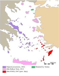
The Dodecanese
These islands were placed under a demilitarization statute after the Second World War by the Treaty of peace with Italy (1947)Treaty of peace with Italy (1947)
The Treaty of Peace with Italy was a treaty signed in Paris on February 10, 1947, between Italy and the victorious powers of World War II, formally ending the hostilities...
, when Italy
Italy
Italy , officially the Italian Republic languages]] under the European Charter for Regional or Minority Languages. In each of these, Italy's official name is as follows:;;;;;;;;), is a unitary parliamentary republic in South-Central Europe. To the north it borders France, Switzerland, Austria and...
ceded them to Greece. Italy had previously not been under any obligation towards Turkey in this respect. Turkey, in turn, was not a party to the 1947 treaty, having been neutral during WWII. Greece therefore holds that the obligations it incurred towards Italy and the other parties in 1947 are res inter alios acta
Res inter alios acta
Res inter alios acta, aliis nec nocet nec prodest is a law doctrine which holds that a contract cannot adversely affect the rights of one who is not a party to the contract....
for Turkey in the sense of Article 34 of the Vienna Convention on the Law of Treaties
Vienna Convention on the Law of Treaties
The Vienna Convention on the Law of Treaties is a treaty concerning the international law on treaties between states. It was adopted on 22 May 1969 and opened for signature on 23 May 1969. The Convention entered into force on 27 January 1980. The VCLT has been ratified by 111 states as of November...
, which states that a treaty does not create obligations or rights for a third country, and that Turkey thus cannot base any claims on them. Turkey argues that the demilitarization agreement constitutes a status treaty (an objective régime), where according to general rules of treaty law such an exclusion does not hold.
The remaining islands
The remaining islands (Lesbos, ChiosChios
Chios is the fifth largest of the Greek islands, situated in the Aegean Sea, seven kilometres off the Asia Minor coast. The island is separated from Turkey by the Chios Strait. The island is noted for its strong merchant shipping community, its unique mastic gum and its medieval villages...
, Samos
Samos Island
Samos is a Greek island in the eastern Aegean Sea, south of Chios, north of Patmos and the Dodecanese, and off the coast of Asia Minor, from which it is separated by the -wide Mycale Strait. It is also a separate regional unit of the North Aegean region, and the only municipality of the regional...
, and Ikaria) were placed under a partial demilitarization statute by the Treaty of Lausanne
Treaty of Lausanne
The Treaty of Lausanne was a peace treaty signed in Lausanne, Switzerland on 24 July 1923, that settled the Anatolian and East Thracian parts of the partitioning of the Ottoman Empire. The treaty of Lausanne was ratified by the Greek government on 11 February 1924, by the Turkish government on 31...
in 1923. It prohibited the establishment of naval bases and fortifications, but allowed Greece to maintain a limited military contingent recruited from the local population, as well as police forces. With respect to these islands, Greece has not claimed that the treaty obligations have been formally superseded. However, in recent years it has argued that it is entitled to discount them, invoking Article 15 of the Charter of the United Nations. It argues that after the Turkish occupation of northern Cyprus
Cyprus
Cyprus , officially the Republic of Cyprus , is a Eurasian island country, member of the European Union, in the Eastern Mediterranean, east of Greece, south of Turkey, west of Syria and north of Egypt. It is the third largest island in the Mediterranean Sea.The earliest known human activity on the...
and the Turkish threat of war over the 12 miles issue, re-armament is an act of legitimate self-defence.
Imia/Kardak
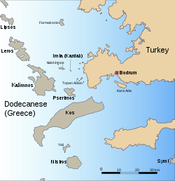
Imia/Kardak
Imia is a pair of two small uninhabited islets in the Aegean Sea, situated between the Greek island chain of the Dodecanese and the southwestern mainland coast of Turkey. They lie west of the coast of Muğla Province, east of the Greek island Kalymnos, and southeast of the nearest small Greek...
, situated between the Dodecanese
Dodecanese
The Dodecanese are a group of 12 larger plus 150 smaller Greek islands in the Aegean Sea, of which 26 are inhabited. Τhis island group generally defines the eastern limit of the Sea of Crete. They belong to the Southern Sporades island group...
island chain and the Turkish mainland. The conflict, triggered by the stranding of a Turkish merchant ship on the islets, was originally caused by factual inconsistencies between maps of the area, some of which assigned these islets to Greece, others to Turkey. The media of the two countries took up the issue and gave it a nationalistic turn, before the two governments even had the time to come to a full technical understanding of the true legal and geographical situation. Both governments finally adopted an intransigent stance, publicly asserting their own claims of sovereignty over the islets. The result was military escalation, which was perceived abroad as quite out of proportion with the size and significance of the rocks in question. The two countries were at the brink of war for a few days, until the crisis was defused with the help of foreign mediation.
During the crisis and in the months following it, both governments elaborated legal arguments to support their claims to sovereignty. The arguments exchanged concerned the interpretation of the Treaty of Lausanne
Treaty of Lausanne
The Treaty of Lausanne was a peace treaty signed in Lausanne, Switzerland on 24 July 1923, that settled the Anatolian and East Thracian parts of the partitioning of the Ottoman Empire. The treaty of Lausanne was ratified by the Greek government on 11 February 1924, by the Turkish government on 31...
of 1923, which forms the principal basis for the legal status of territories in most of the region, as well as certain later diplomatic dealings between Turkey, Greece and Italy.
Other "Grey Zones"
In the wake of the Imia crisis, the Turkish government widened its argumentation to include not only Imia but also a possibly large number of other islands and small formations across the Aegean. Since then, Turkish authorities have spoken of "grey zones" of undetermined sovereignty. According to the Turkish argument, these islets, while not explicitly retained under Turkish sovereignty in 1923, were also not explicitly ceded to any other country, and their sovereignty has therefore remained objectively undecided.The Turkish government has avoided stating exactly which islets it wishes to include in this category. On various occasions, Turkish government sources have indicated that islands such as Pserimos
Pserimos
Pserimos is a small Greek island in the Dodecanese chain, lying between Kalymnos and Kos in front of the coast of Turkey. It is part of the municipality of Kálymnos, and reported a population of 130 inhabitants at the 2001 census....
, Agathonisi
Agathonisi
Agathonísi is a small Greek island and municipality located at the northernmost point of the Dodecanese in Greece.It is surrounded by many smaller islands and is home to two villages, both inland; Megálo Chorió , and Mikró Chorió . The island's only port is the settlement of Agios Georgios ,...
, Fournoi and Gavdos
Gavdos
Gavdos is the southernmost Greek island, located to the south of its much bigger neighbour, Crete, of which it is administratively a part, in the peripheral unit of Chania. It forms a community with surrounding islets and was part of the former Selino Province. It is the southernmost point of...
(situated south of Crete
Crete
Crete is the largest and most populous of the Greek islands, the fifth largest island in the Mediterranean Sea, and one of the thirteen administrative regions of Greece. It forms a significant part of the economy and cultural heritage of Greece while retaining its own local cultural traits...
) might be included. Most of them, unlike Imia/Kardak, had undeniably been in factual Greek possession, which had never previously been challenged by Turkey, and many are inhabited. In a 2004 publication by Turkish authors close to the Turkish military leadership the following (among other, even smaller ones) were listed as potentially "grey" areas:
- Kalogeroi,
- AntipsaraAntipsaraAntipsara is a small, Greek island in the Aegean Sea.Antipsara had 4 inhabitants according to the 2011 census. It lies about 3 km west of the larger island Psara, from which its name is derived. Geographic conditions make it inaccessible from the north and west side. Evidence exists of settlement...
(west of the islands of Psara and Khios), - Pontiko (between SamosSamos IslandSamos is a Greek island in the eastern Aegean Sea, south of Chios, north of Patmos and the Dodecanese, and off the coast of Asia Minor, from which it is separated by the -wide Mycale Strait. It is also a separate regional unit of the North Aegean region, and the only municipality of the regional...
and the Turkish coast), - Fournoi,
- ArkoiArkoiArki is a small Greek island which is part of the Dodecanese archipelago. It is situated in the eastern Aegean Sea, close to the Turkish Aegean Coast...
, - AgathonisiAgathonisiAgathonísi is a small Greek island and municipality located at the northernmost point of the Dodecanese in Greece.It is surrounded by many smaller islands and is home to two villages, both inland; Megálo Chorió , and Mikró Chorió . The island's only port is the settlement of Agios Georgios ,...
(Gaidaros), - PharmakonisiPharmakonisiFarmakonisi is a small Greek island of the Dodecanese prefecture. Alternative names are Pharmakos, Pharmacusa, Farmaco, and Pharmakousa ....
, - KalolimnosKalolimnosKalolimnos is a small Greek island in the Dodecanese chain, lying between Kalymnos and Imia, opposite the coast of Turkey. It is part of the municipality of Kálymnos....
(near Imia/Kardak), - PserimosPserimosPserimos is a small Greek island in the Dodecanese chain, lying between Kalymnos and Kos in front of the coast of Turkey. It is part of the municipality of Kálymnos, and reported a population of 130 inhabitants at the 2001 census....
, - GyaliGyaliGyali is a volcanic Greek island in the Dodecanese, located halfway between the south coast of Kos and Nisyros. It consists of rhyolitic obsidian lava domes and pumice deposits. The island has two distinct segments, with the northeastern part almost entirely made of obsidian and the southwestern...
(between KosKosKos or Cos is a Greek island in the south Sporades group of the Dodecanese, next to the Gulf of Gökova/Cos. It measures by , and is from the coast of Bodrum, Turkey and the ancient region of Caria. Administratively the island forms a separate municipality within the Kos peripheral unit, which is...
and NisyrosNisyrosNisyros is a volcanic Greek island and municipality located in the Aegean Sea. It is part of the Dodecanese group of islands, situated between the islands of Kos and Tilos. Its shape is approximately round, with a diameter of about , and an area of . Several other islets are found in the direct...
), - Kandheliousa (south of KosKosKos or Cos is a Greek island in the south Sporades group of the Dodecanese, next to the Gulf of Gökova/Cos. It measures by , and is from the coast of Bodrum, Turkey and the ancient region of Caria. Administratively the island forms a separate municipality within the Kos peripheral unit, which is...
), - Sirina (SE of AstypalaiaAstypalaiaAstypalaia , called in Italian Stampalia and in Ottoman Turkish İstanbulya , is a Greek island with 1,238 residents . It belongs to the Dodecanese, an island group of twelve major islands in the southeastern Aegean Sea. The island is 18 km. long, 13 km. wide at the most, and covers an...
)
While Turkey has not made any attempt at challenging the Greek possession of these islands on the ground, the claims add to the number of minor military incidents, already numerous due to the 10-mile airspace and the FIR issues. The Turkish air force has reportedly adopted a policy of ignoring Greek claims to all airspace and territorial waters around such formations that it counts as grey zones. According to Greek press reports, the number of airspace violations within the 6-mile limit recognised by Ankara rose sharply in 2006, as did the number of unauthorised Turkish military flights directly over Greek islands themselves. Renewed reports of systematic Turkish military flights directly over Greek islands like Pharmakonisi and Agathonisi were made in late 2008 and early 2009.
Turkish incidents with Frontex
In September 2009, a TurkishTurkey
Turkey , known officially as the Republic of Turkey , is a Eurasian country located in Western Asia and in East Thrace in Southeastern Europe...
military radar issued a warning to a Latvia
Latvia
Latvia , officially the Republic of Latvia , is a country in the Baltic region of Northern Europe. It is bordered to the north by Estonia , to the south by Lithuania , to the east by the Russian Federation , to the southeast by Belarus and shares maritime borders to the west with Sweden...
n helicopter patrolling in the eastern Aegean
Aegean Sea
The Aegean Sea[p] is an elongated embayment of the Mediterranean Sea located between the southern Balkan and Anatolian peninsulas, i.e., between the mainlands of Greece and Turkey. In the north, it is connected to the Marmara Sea and Black Sea by the Dardanelles and Bosporus...
—part of the EU's Frontex
Frontex
Frontex is the European Union agency for external border security...
programme to combat illegal immigration—to leave the area. The Turkish General Staff reported that the Latvian Frontex aircraft had violated Turkish airspace west of Didim
Didim
Didim, home of the antique city of Didyma with its ruined Temple of Apollo, is a small town, popular seaside holiday resort and district of Aydın Province on the Aegean coast of western Turkey, from the city of Aydın.-Geography:...
.
According to a Hellenic Air Force
Hellenic Air Force
The Hellenic Air Force, abbreviated to HAF is the air force of Greece. The mission of the Hellenic Air Force is to guard and protect Greek airspace, provide air assistance and support to the Hellenic Army and the Hellenic Navy, as well as the provision of humanitarian aid in Greece and around the...
announcement, the incident occurred as the Frontex helicopter—identified as an Italian-made Agusta A109
Agusta A109
The AgustaWestland AW109 is a light-weight, twin-engine, eight-seat multi-purpose helicopter built by the Anglo-Italian manufacturer AgustaWestland...
—was patrolling in Greek air space near the small isle of Farmakonisi, which lies on a favorite route used by migrant smuggler
People smuggling
People smuggling is defined as "the facilitation, transportation, attempted transportation or illegal entry of a person or persons across an international border, in violation of one or more countries laws, either clandestinely or through deception, such as the use of fraudulent documents"...
s ferrying mostly Third World
Third World
The term Third World arose during the Cold War to define countries that remained non-aligned with either capitalism and NATO , or communism and the Soviet Union...
migrants into Greece and the EU from the opposite Turkish coastline. Frontex officials stated that they simply ignored the Turkish warnings as they were not in Turkish airspace and continued their duties. Frontex later took photographs of the Turkish Coast Guard escorting illegal immigrants
Illegal immigration
Illegal immigration is the migration into a nation in violation of the immigration laws of that jurisdiction. Illegal immigration raises many political, economical and social issues and has become a source of major controversy in developed countries and the more successful developing countries.In...
towards Greek waters and the photos accompanied by written evidence were submitted to EU authorities.
Another incident took place on October 2009 in the aerial area above the eastern Aegean sea, off the island of Lesbos. On 20 November 2009, the Turkish General Staff issued a press note alleging that an Estonian Border Guard aircraft Let
Let Kunovice
Aircraft Industries, a.s., operating as Let Kunovice, is a Czech civil aircraft manufacturer. Its most successful design has been the L-410 Turbolet, of which more than 1000 units have been built...
L-410 UVP taking off from Kos
Kos
Kos or Cos is a Greek island in the south Sporades group of the Dodecanese, next to the Gulf of Gökova/Cos. It measures by , and is from the coast of Bodrum, Turkey and the ancient region of Caria. Administratively the island forms a separate municipality within the Kos peripheral unit, which is...
on a Frontex mission had violated Turkish airspace west of Söke
Söke
Söke is a town and a large district of Aydın Province in the Aegean region of western Turkey, south-west of the city of Aydın, near the Aegean coast. It had 68,020 population in 2010.- Geography :...
.
Strategies of conflict resolution
The decades since the 1970s have seen a repeated heightening and abating of political and military tensions over the Aegean. Thus, the Sismik incidentSismik incident
In late March 1987, the Turkish survey ship Sismik was about to enter Greek waters and conduct survey. Possibly the Greek intelligence reported the intention to Prime Minister Andreas Papandreou. Papandreou gave the orders to sink the ship, if found within Greek waters. This incident nearly started...
of 1987 was followed by a series of negotiations and agreements in Davos
Davos
Davos is a municipality in the district of Prättigau/Davos in the canton of Graubünden, Switzerland. It has a permanent population of 11,248 . Davos is located on the Landwasser River, in the Swiss Alps, between the Plessur and Albula Range...
and Brussels
Brussels
Brussels , officially the Brussels Region or Brussels-Capital Region , is the capital of Belgium and the de facto capital of the European Union...
in 1988. Again, after the Imia/Kardak crisis of 1996, there came an agreement over peaceful neighbourly relations reached at a meeting in Madrid
Madrid
Madrid is the capital and largest city of Spain. The population of the city is roughly 3.3 million and the entire population of the Madrid metropolitan area is calculated to be 6.271 million. It is the third largest city in the European Union, after London and Berlin, and its metropolitan...
in 1997. The period since about 1999 has been marked by a steady improvement of bilateral relations.
For years, the Aegean dispute has been a matter not only about conflicting claims of substance. Rather, proposed strategies of how to resolve the substantial differences have themselves constituted a matter of heated dispute. Whereas Turkey has traditionally preferred to regard the whole set of topics as a political issue, requiring bilateral political negotiation, Greece views them as separate and purely legal issues, requiring only the application of existing principles of international law. Turkey has advocated direct negotiation, with a view to establishing what it would regard as an equitable compromise. Greece refuses to accept any process that would put it under pressure to engage in a give-and-take over what it perceives as inalienable and unnegotiable sovereign rights. Up to the late 1990s, the only avenue of conflict resolution that Greece deemed acceptable was to submit the issues separately to the International Court of Justice
International Court of Justice
The International Court of Justice is the primary judicial organ of the United Nations. It is based in the Peace Palace in The Hague, Netherlands...
in The Hague
The Hague
The Hague is the capital city of the province of South Holland in the Netherlands. With a population of 500,000 inhabitants , it is the third largest city of the Netherlands, after Amsterdam and Rotterdam...
.
The resulting stalemate between both sides over process was partially changed after 1999, when the European summit of Helsinki opened up a path towards Turkey's accession to the EU
Accession of Turkey to the European Union
Turkey's application to accede to the European Union was made on 14 April 1987. Turkey has been an associate member of the European Union and its predecessors since 1963...
. In the summit agreement, Turkey accepted an obligation to solve its bilateral disputes with Greece before actual accession talks would start. This was perceived as giving Greece a new tactical advantage over Turkey in determining which paths of conflict resolution to choose. During the following years, both countries held regular bilateral talks on the level of technical specialists, trying to determine possible future procedures. According to press reports , both sides seemed close to an agreement about how to submit the dispute to the court at The Hague, a step which would have fulfilled many of the old demands of Greece. However, a newly elected Greek government under Kostas Karamanlis, soon after it took office in March 2004, opted out of this plan, because Ankara was insisting that all the issues, including Imia/Kardak and the "grey zones", belonged to a single negotiating item. Athens saw them as separate. However, Greek policy remained at the forefront in advocating closer links between Ankara and the EU. This resulted in the European Union finally opening accession talks with Turkey without its previous demands having been fulfilled.