

Benham Plateau
Encyclopedia
Philippines
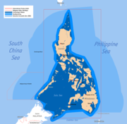
The Philippines , officially known as the Republic of the Philippines , is a country in Southeast Asia in the western Pacific Ocean. To its north across the Luzon Strait lies Taiwan. West across the South China Sea sits Vietnam...
, in the Philippine Sea
Philippine Sea
The Philippine Sea is a marginal sea east and north of the Philippines occupying an estimated surface area of 2 million mi² on the western part of the North Pacific Ocean...
. Under the Philippine Sea lies a number of Basins including the West Philippine Basin (WPB) of which inside the Basin is located the Central Basin Fault (CBF). The Benham Plateau is located in the CBF and its basement probably represents a micro-continent. Several scientific surveys have been made on the feature to study its nature and its impact on tectonic
Plate tectonics
Plate tectonics is a scientific theory that describes the large scale motions of Earth's lithosphere...
subduction
Subduction
In geology, subduction is the process that takes place at convergent boundaries by which one tectonic plate moves under another tectonic plate, sinking into the Earth's mantle, as the plates converge. These 3D regions of mantle downwellings are known as "Subduction Zones"...
, including one about its effects on the 1990 Luzon earthquake
1990 Luzon earthquake
The Luzon earthquake occurred on Monday, July 16, 1990, at 4:26 PM local time in the Philippines. The densely populated island of Luzon was struck by an earthquake with a 7.8 Ms...
, which devastated the northern city of Baguio. The area is currently claimed, as part of its continental shelf
Continental shelf
The continental shelf is the extended perimeter of each continent and associated coastal plain. Much of the shelf was exposed during glacial periods, but is now submerged under relatively shallow seas and gulfs, and was similarly submerged during other interglacial periods. The continental margin,...
, by the Republic of the Philippines, which has lodged a claim with the United Nations
United Nations
The United Nations is an international organization whose stated aims are facilitating cooperation in international law, international security, economic development, social progress, human rights, and achievement of world peace...
Commission on the Limits of the Continental Shelf on April 8, 2009.
Geological features
Luzon
Luzon is the largest island in the Philippines. It is located in the northernmost region of the archipelago, and is also the name for one of the three primary island groups in the country centered on the Island of Luzon...
, with the size of about 250 km in diameter and rises over 2,000 meters above the sea floor, from below 5,000 meters below sea level to above 3,000 meters below sea level. Its area is close to the Benham Seamount, located at 15 degrees 48 minutes N, 124 degrees 15 minutes E. The precise location is somewhere near the east of the Philippine Trench
Philippine Trench
The Philippine Trench is a submarine trench to the east of the Philippines. It has a length of approximately 1,320 km and a width of about 30 km from the centre of the Philippine island of Luzon trending southeast to the northern Maluku island of Halmahera in Indonesia...
and near the south of the East Luzon Trench, both of which absorb the subducting force of the Philippine Sea Plate under the Philippine Mobile Belt
Philippine Mobile Belt
The Philippine Mobile Belt is a complex portion of the tectonic boundary between the Eurasian Plate and the Philippine Sea Plate, comprising most of the country of the Philippines. It includes two subduction zones, the Manila Trench to the west and the Philippine Trench to the east, as well as the...
, a collage of large blocks of that crust that amalgamated prior to the collision of the Philippine Sea Plate with the Eurasian Plate
Eurasian Plate
The Eurasian Plate is a tectonic plate which includes most of the continent of Eurasia , with the notable exceptions of the Indian subcontinent, the Arabian subcontinent, and the area east of the Chersky Range in East Siberia...
.
The origin of the landform, along with a fellow landform, the Urdaneta Plateau (a remnant of mantle plume
Plume
Plume may refer to:In science:* Plume , the form of effluent in water or emissions in air* Eruption column, or volcanic plume, a column of hot volcanic ash and gas emitted into the atmosphere during an explosive volcanic eruption...
), is identified in one study as at least five sequences of propagating rift
Rift
In geology, a rift or chasm is a place where the Earth's crust and lithosphere are being pulled apart and is an example of extensional tectonics....
s, probably triggered by mantle
Mantle (geology)
The mantle is a part of a terrestrial planet or other rocky body large enough to have differentiation by density. The interior of the Earth, similar to the other terrestrial planets, is chemically divided into layers. The mantle is a highly viscous layer between the crust and the outer core....
flowing away from the mantle thermal anomaly. Its presence of the landform disrupts the continuity of this region (known as the Philippine-East Luzon Trench) by continuously colliding with the Sierra Madre mountain range
Sierra Madre (Philippines)
The Sierra Madre is a mountain range in The Philippines. It is located along the north-eastern coast of Luzon Island, running north/south. Quezon National Forest Park is situated in the range.-Geography:...
of eastern portion of the island of Luzon
Luzon
Luzon is the largest island in the Philippines. It is located in the northernmost region of the archipelago, and is also the name for one of the three primary island groups in the country centered on the Island of Luzon...
. Though it is generally thought that the Philippine Sea Plate is being subducted under the Philippine Mobile Belt
Philippine Mobile Belt
The Philippine Mobile Belt is a complex portion of the tectonic boundary between the Eurasian Plate and the Philippine Sea Plate, comprising most of the country of the Philippines. It includes two subduction zones, the Manila Trench to the west and the Philippine Trench to the east, as well as the...
, under the rules of tectonic
Plate tectonics
Plate tectonics is a scientific theory that describes the large scale motions of Earth's lithosphere...
subduction
Subduction
In geology, subduction is the process that takes place at convergent boundaries by which one tectonic plate moves under another tectonic plate, sinking into the Earth's mantle, as the plates converge. These 3D regions of mantle downwellings are known as "Subduction Zones"...
, there appears to be a resistance to this because of the presence of the landform, and instead, the plate is being displaced into the northern portion of Luzon to the west.
The geophysical features of the plateau may have been the result of an early Miocene
Miocene
The Miocene is a geological epoch of the Neogene Period and extends from about . The Miocene was named by Sir Charles Lyell. Its name comes from the Greek words and and means "less recent" because it has 18% fewer modern sea invertebrates than the Pliocene. The Miocene follows the Oligocene...
collision event between the Benham Rise and the eastern margin of Luzon, which may have also allowed the inception of the NW striking strand of the Philippine fault. These forces may have impacted the shape of the island of Luzon
Luzon
Luzon is the largest island in the Philippines. It is located in the northernmost region of the archipelago, and is also the name for one of the three primary island groups in the country centered on the Island of Luzon...
because of the basalt
Basalt
Basalt is a common extrusive volcanic rock. It is usually grey to black and fine-grained due to rapid cooling of lava at the surface of a planet. It may be porphyritic containing larger crystals in a fine matrix, or vesicular, or frothy scoria. Unweathered basalt is black or grey...
ic sea floor resisting the subduction that may have also cause the bending of the Philippine Fault. The active basins in Central Luzon
Central Luzon
Central Luzon , also known as Region III , is an administrative division or region of the Republic of the Philippines, primarily serve to organize the 7 provinces of the vast central plain of the island of Luzon , for administrative convenience...
, which trace an asymmetrical V shape, is the best place to observe recent tectonic evolution of the fault system.
History
The landform is presumably named after Admiral Andrew Ellicot Kennedy Benham (1832–1905) by AmericanUnited States
The United States of America is a federal constitutional republic comprising fifty states and a federal district...
surveyors who were the probable discoverers of the geological feature. He was a United States Navy
United States Navy
The United States Navy is the naval warfare service branch of the United States Armed Forces and one of the seven uniformed services of the United States. The U.S. Navy is the largest in the world; its battle fleet tonnage is greater than that of the next 13 largest navies combined. The U.S...
officer, who served with both the South Atlantic and West Gulf Blockading Squadrons during the American Civil War
American Civil War
The American Civil War was a civil war fought in the United States of America. In response to the election of Abraham Lincoln as President of the United States, 11 southern slave states declared their secession from the United States and formed the Confederate States of America ; the other 25...
. There has been speculation in the scientific community about the nature of the landform. Following the major 16 July 1990 Luzon earthquake
1990 Luzon earthquake
The Luzon earthquake occurred on Monday, July 16, 1990, at 4:26 PM local time in the Philippines. The densely populated island of Luzon was struck by an earthquake with a 7.8 Ms...
, scientists reconsidered their fault models and decided it likely that Benham Plateau has similarly displaced the Philippine Fault System
Philippine Fault System
The Philippine Fault System is an inter-related system of faults throughout the whole of the Philippine Archipelago, primarily caused by tectonic forces compressing the Philippines into what tectonic geophysicists call the Philippine Mobile Belt....
to the west. After analysing older models such as that of Pinet and Stephan (1989), scientists reconsidered their fault models. They thought that it is highly likely that the Benham Plateau is still displacing Central Luzon
Central Luzon
Central Luzon , also known as Region III , is an administrative division or region of the Republic of the Philippines, primarily serve to organize the 7 provinces of the vast central plain of the island of Luzon , for administrative convenience...
and the Philippine Fault System
Philippine Fault System
The Philippine Fault System is an inter-related system of faults throughout the whole of the Philippine Archipelago, primarily caused by tectonic forces compressing the Philippines into what tectonic geophysicists call the Philippine Mobile Belt....
to the west, which may have had an impact in causing such a catastrophic earthquake. The 20 second to 50 second wave in the 1990 quake that developed a new east-west sub-fault was so strong that it terminated disastrously at the city of Baguio in Benguet
Benguet
Benguet is a landlocked province of the Philippines in the Cordillera Administrative Region in Luzon. Its capital is La Trinidad and borders, clockwise from the south, Pangasinan, La Union, Ilocos Sur, Mountain Province, Ifugao, and Nueva Vizcaya....
, Cordillera
Cordillera Administrative Region
The Cordillera Administrative Region is a region in the Philippines composed of the provinces of Abra, Apayao, Benguet, Ifugao, Kalinga and Mountain Province, as well as Baguio City, the regional center. The Cordillera Administrative Region encompasses most of the areas within the Cordillera...
. Several scientific surveys, conducted between 2004 to 2008, collected hydrographic data that determined the morphology of the seabed in the region. Additional data from international bathymetric surveys and an analysis of international research projects were collected to support the findings.
Philippine claim
Despite its proximity to the archipelago, the plateau was previously not included in the territory of the Philippine Islands. On 8 April 2009, the Republic of the PhilippinesPhilippines
The Philippines , officially known as the Republic of the Philippines , is a country in Southeast Asia in the western Pacific Ocean. To its north across the Luzon Strait lies Taiwan. West across the South China Sea sits Vietnam...
lodged a partial territorial waters
Territorial waters
Territorial waters, or a territorial sea, as defined by the 1982 United Nations Convention on the Law of the Sea, is a belt of coastal waters extending at most from the baseline of a coastal state...
claim with the United Nations Commission on the Limits of the Continental Shelf in relation to the continental shelf in the region of Benham Rise. It was submitted as part of petition expanding the archipelago's baselines and exclusive economic zone
Exclusive Economic Zone
Under the law of the sea, an exclusive economic zone is a seazone over which a state has special rights over the exploration and use of marine resources, including production of energy from water and wind. It stretches from the seaward edge of the state's territorial sea out to 200 nautical...
through a law that also included other claims involving disputed territories of the Kalayaan Islands (Spratly Islands
Spratly Islands
The Spratly Islands are a group of more than 750 reefs, islets, atolls, cays and islands in the South China Sea. The archipelago lies off the coasts of the Philippines and Malaysia , about one third of the way from there to southern Vietnam. They comprise less than four square kilometers of land...
) and Scarborough Shoal
Scarborough Shoal
Scarborough Shoal or Scarborough Reef , more correctly described as a group of islands and reefs in an atoll shape than a shoal, is located between the Macclesfield Bank and Luzon, Philippines in the South China Sea. As with most of the landforms in this sea, the sovereignty of the area is disputed...
. Although the landform, in itself, is not disputed, the petition still received some criticism inside and outside the country because of its controversial nature. According to the government's claim, based on a set of guidelines by the Commission on the Limits of the Continental Shelf, the area satisfies the 350-mile constraint line since the outer limits of the continental shelf are located landward of the constraint line, which is located 350 miles from the baselines where the measurement of the breadth of the territorial sea begins.
The Congress of the Philippines
Congress of the Philippines
The Congress of the Philippines is the national legislature of the Republic of the Philippines. It is a bicameral body consisting of the Senate , and the House of Representatives although commonly in the Philippines the term congress refers to the latter.The Senate is composed of 24 senators half...
enacted Republic Act No. 9522, also known as the Archipelagic Baselines Law, which is the basis of the claim. According to the document the region is bounded by the Philippine Basin on the north and east, and by Luzon on the west and south. It asserted that, according to scientific data based on seismic, magnetic, other geological features, the Benham Rise is an extension of the Philippines’ continental shelf. In summary, the baselines, the basis used for delineating the maritime territorial and jurisdictional zones (including the continental shelf), conform with the requirements of the UN Convention of the Law of the Sea (UNCLOS). The claim is only a partial claim since the law that allows the Philippines to expand its territorial boundaries also includes islands in the South China Sea
South China Sea
The South China Sea is a marginal sea that is part of the Pacific Ocean, encompassing an area from the Singapore and Malacca Straits to the Strait of Taiwan of around...
.
U.N Decision
According to, Philippine Environment Secretary Ramon Paje,the United NationsUnited Nations
The United Nations is an international organization whose stated aims are facilitating cooperation in international law, international security, economic development, social progress, human rights, and achievement of world peace...
is expected to come out with a decision by the middle of 2012 on the Philippines’undisputed claim over the 13- million hectare Benham Rise. Paje told the Senate during a hearing on the Department of Environment and Natural Resources (DENR) proposed P16.990- billion budget for 2012 that the country’s claim over Benham Rise would be recognized by the UN as part of the territory and extension of the continental shelf of the Philippines.The Philippines
Philippines
The Philippines , officially known as the Republic of the Philippines , is a country in Southeast Asia in the western Pacific Ocean. To its north across the Luzon Strait lies Taiwan. West across the South China Sea sits Vietnam...
filed the claim in 2008 in compliance with the requirements of the UN Convention on the Law of the Sea (UNCLOS).