
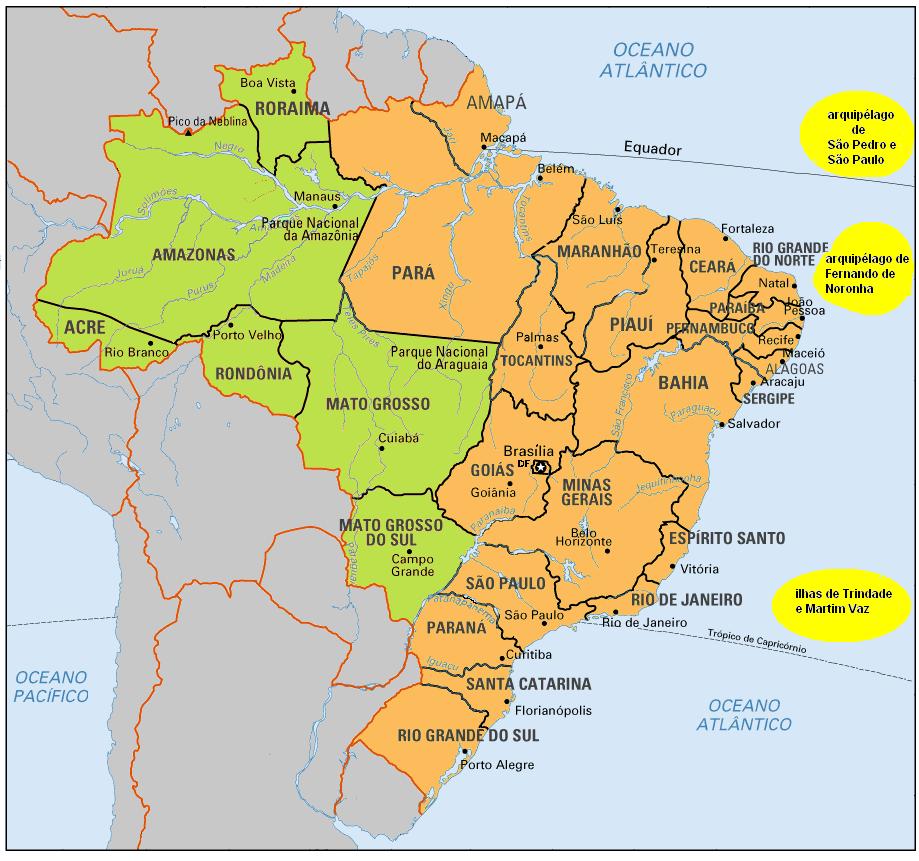
States of Brazil
Encyclopedia
The Federative Republic of Brazil
Brazil
Brazil , officially the Federative Republic of Brazil , is the largest country in South America. It is the world's fifth largest country, both by geographical area and by population with over 192 million people...
is a union of twenty-seven Federative Units : twenty-six states (estados; singular estado) and one federal district (Distrito Federal
Brazilian Federal District
The Federal District is set apart for Brasília, the capital of Brazil. Located in a region called Planalto Central, or Central Plateau, the Federal District is divided in 29 administrative regions. Brasilia - place where the three branches of the Federal Government are located - is the main...
) which contains the capital city
Capital City
Capital City was a television show produced by Euston Films which focused on the lives of investment bankers in London living and working on the corporate trading floor for the fictional international bank Shane-Longman....
, Brasília
Brasília
Brasília is the capital city of Brazil. The name is commonly spelled Brasilia in English. The city and its District are located in the Central-West region of the country, along a plateau known as Planalto Central. It has a population of about 2,557,000 as of the 2008 IBGE estimate, making it the...
. The states are generally based on historical, conventional borders which have developed over time, though some boundaries are arbitrary. The federal district is not a state in its own right, but shares some characteristics of a state and some of a municipality. The Federal District is bordered by the states of Goiás
Goiás
Goiás is a state of Brazil, located in the central part of the country. The name Goiás comes from the name of an indigenous community...
and Minas Gerais
Minas Gerais
Minas Gerais is one of the 26 states of Brazil, of which it is the second most populous, the third richest, and the fourth largest in area. Minas Gerais is the Brazilian state with the largest number of Presidents of Brazil, the current one, Dilma Rousseff, being one of them. The capital is the...
. The codes given below are defined in ISO 3166-2:BR
ISO 3166-2:BR
ISO 3166-2:BR is the entry for Brazil in ISO 3166-2, part of the ISO 3166 standard published by the International Organization for Standardization , which defines codes for the names of the principal subdivisions of all countries coded in ISO 3166-1.Currently for Brazil, ISO 3166-2 codes are...
.
History
The first administrative divisions of Brazil were the hereditary captainciesCaptaincy
A captaincy is a historical administrative division of the former Spanish and Portuguese colonial empires. Each was governed by a captain general.-In the Portuguese Empire:...
(capitanias hereditárias), stretches of land leased to Portuguese noblemen or merchants with a charter to colonize the land. The captaincies were to be passed from father to son, but the crown retained the power of revoking it, which the king indeed did in the 16th century. Then the vast Portuguese dominion in South America was divided between the State of Brazil, in the southern half, and the State of Maranhão, in the northern half (note that Maranhão by then referred not only to current Maranhão
Maranhão
Maranhão is a northeastern state of Brazil. To the north lies the Atlantic Ocean. Maranhão is neighbored by the states of Piauí, Tocantins and Pará. The people of Maranhão have a distinctive accent...
, but rather to the whole of the Amazon region; the name marã-nã in Old Tupi language
Old Tupi language
Old Tupi or Classical Tupi is an extinct Tupian language which was spoken by the native Tupi people of Brazil, mostly those who lived close to the sea. It belongs to the Tupi–Guarani language family, and which has a written history spanning the 16th, 17th and early 18th centuries...
means "wide river", i.e. the Amazon River
Amazon River
The Amazon of South America is the second longest river in the world and by far the largest by waterflow with an average discharge greater than the next seven largest rivers combined...
).
After the Iberian Union
Iberian Union
The Iberian union was a political unit that governed all of the Iberian Peninsula south of the Pyrenees from 1580–1640, through a dynastic union between the monarchies of Portugal and Spain after the War of the Portuguese Succession...
(1580–1640), the territory of Portuguese colonial domains in South America was more than doubled, and the land was divided into captaincies, royal captaincies and provinces. Unlike Spanish America, the whole territory was united under a single viceroy
Viceroy
A viceroy is a royal official who runs a country, colony, or province in the name of and as representative of the monarch. The term derives from the Latin prefix vice-, meaning "in the place of" and the French word roi, meaning king. A viceroy's province or larger territory is called a viceroyalty...
, with a seat in Salvador
Salvador, Bahia
Salvador is the largest city on the northeast coast of Brazil and the capital of the Northeastern Brazilian state of Bahia. Salvador is also known as Brazil's capital of happiness due to its easygoing population and countless popular outdoor parties, including its street carnival. The first...
(and after 1763, Rio de Janeiro
Rio de Janeiro
Rio de Janeiro , commonly referred to simply as Rio, is the capital city of the State of Rio de Janeiro, the second largest city of Brazil, and the third largest metropolitan area and agglomeration in South America, boasting approximately 6.3 million people within the city proper, making it the 6th...
). This situation contributed later to keeping Brazil as a unified nation-state and avoiding the fragmentation of the Spanish domains.
With independence, in 1822, the colony became an empire and all captaincies were turned into provinces. Most internal borders were kept unchanged from the colonial period, generally following natural features such as rivers and mountain ridges. Minor changes were made to suit domestic politics (such as the Triângulo Mineiro
Triângulo Mineiro
The Triangle Mineiro Portuguese pronunciation: [tɾiɐɡulu minejru] is an officer in the region west of the state of Minas Gerais, Brazil. The area is 93.500 km ² and is limited by the Serra da Canastra and Marcela, east, south of Sao Paulo, Goias in the north and west of the junction of the rivers...
from Goiás
Goiás
Goiás is a state of Brazil, located in the central part of the country. The name Goiás comes from the name of an indigenous community...
to Minas Gerais
Minas Gerais
Minas Gerais is one of the 26 states of Brazil, of which it is the second most populous, the third richest, and the fourth largest in area. Minas Gerais is the Brazilian state with the largest number of Presidents of Brazil, the current one, Dilma Rousseff, being one of them. The capital is the...
, the splitting of Paraná
Paraná (state)
Paraná is one of the states of Brazil, located in the South of the country, bordered on the north by São Paulo state, on the east by the Atlantic Ocean, on the south by Santa Catarina state and the Misiones Province of Argentina, and on the west by Mato Grosso do Sul and the republic of Paraguay,...
and the left bank of the São Francisco River
São Francisco River
The São Francisco is a river in Brazil. With a length of , it is the longest river that runs entirely in Brazilian territory, and the fourth longest in South America and overall in Brazil...
from Pernambuco
Pernambuco
Pernambuco is a state of Brazil, located in the Northeast region of the country. To the north are the states of Paraíba and Ceará, to the west is Piauí, to the south are Alagoas and Bahia, and to the east is the Atlantic Ocean. There are about of beaches, some of the most beautiful in the...
to Bahia
Bahia
Bahia is one of the 26 states of Brazil, and is located in the northeastern part of the country on the Atlantic coast. It is the fourth most populous Brazilian state after São Paulo, Minas Gerais and Rio de Janeiro, and the fifth-largest in size...
), as well as additions resulting from diplomatic settlement of territorial disputes by the end of the 19th century (Amapá
Amapá
Amapá is one of the states of Brazil, located in the extreme north, bordering French Guiana and Suriname to the north. To the east is the Atlantic Ocean, and to the south and west is the Brazilian state of Pará. Perhaps one of the main features of the state is the River Oiapoque, as it was once...
, Roraima
Roraima
Roraima is the northernmost and least populated state of Brazil, located in the Amazon region. It borders the states of Amazonas and Pará, as well as the nations of Venezuela and Guyana. The population is 400,000 and the capital is Boa Vista...
, Palmas
Palmas
Palmas may refer to:* Palmas, one of the two sectors of Cataño, Puerto Rico* Palmas, Tocantins, the capital of the state of Tocantins in Brazil* Palmas, Paraná, a centenary small city in the south of the state of Paraná in Brazil...
). When Brazil became a republic in 1889, all provinces were immediately turned into states.
In 1943, with the entrance of Brazil into the Second World War, the Vargas regime
Getúlio Vargas
Getúlio Dornelles Vargas served as President of Brazil, first as dictator, from 1930 to 1945, and in a democratically elected term from 1951 until his suicide in 1954. Vargas led Brazil for 18 years, the most for any President, and second in Brazilian history to Emperor Pedro II...
detached seven strategic territories from the border of the country in order to administer them directly: Amapá
Amapá
Amapá is one of the states of Brazil, located in the extreme north, bordering French Guiana and Suriname to the north. To the east is the Atlantic Ocean, and to the south and west is the Brazilian state of Pará. Perhaps one of the main features of the state is the River Oiapoque, as it was once...
, Rio Branco
Roraima
Roraima is the northernmost and least populated state of Brazil, located in the Amazon region. It borders the states of Amazonas and Pará, as well as the nations of Venezuela and Guyana. The population is 400,000 and the capital is Boa Vista...
, Acre
Acre (state)
Acre is one of the 27 states of Brazil. It is situated in the southwest of the Northern Region, bordering Amazonas to the north, Rondônia to the east, Bolivia to the southeast and the Ucayali Region of Peru to the south and west. It occupies an area of 152,581.4 km2, being slightly smaller...
, Guaporé
Rondônia
Rondônia is a state in Brazil, located in the north-western part of the country. To the west is a short border with the state of Acre, to the north is the state of Amazonas, in the east is Mato Grosso, and in the south is Bolivia. Its capital is Porto Velho. The state was named after Candido Rondon...
, Ponta Porã, Iguaçu and the archipelago of Fernando de Noronha
Fernando de Noronha
Fernando de Noronha is an archipelago of 21 islands and islets in the Atlantic Ocean, offshore from the Brazilian coast. The main island has an area of and had a population of 3,012 in the year 2010...
. After the war, the first three territories became states, with Rio Branco and Guaporé being renamed Roraima and Rondônia, respectively, whilst Ponta Porã and Iguaçu remained as territories. In 1988, Fernando de Noronha became part of Pernambuco
Pernambuco
Pernambuco is a state of Brazil, located in the Northeast region of the country. To the north are the states of Paraíba and Ceará, to the west is Piauí, to the south are Alagoas and Bahia, and to the east is the Atlantic Ocean. There are about of beaches, some of the most beautiful in the...
.
In 1960, the square-shaped Distrito Federal
Brazilian Federal District
The Federal District is set apart for Brasília, the capital of Brazil. Located in a region called Planalto Central, or Central Plateau, the Federal District is divided in 29 administrative regions. Brasilia - place where the three branches of the Federal Government are located - is the main...
was carved out of Goiás
Goiás
Goiás is a state of Brazil, located in the central part of the country. The name Goiás comes from the name of an indigenous community...
in preparation for the new capital, Brasília
Brasília
Brasília is the capital city of Brazil. The name is commonly spelled Brasilia in English. The city and its District are located in the Central-West region of the country, along a plateau known as Planalto Central. It has a population of about 2,557,000 as of the 2008 IBGE estimate, making it the...
. The previous federal district became the state of Guanabara until in 1975 it was merged with the state of Rio de Janeiro
Rio de Janeiro (state)
Rio de Janeiro is one of the 27 states of Brazil.Rio de Janeiro has the second largest economy of Brazil behind only São Paulo state.The state of Rio de Janeiro is located within the Brazilian geopolitical region classified as the Southeast...
, retaining its name and with the municipality of Rio de Janeiro
Rio de Janeiro
Rio de Janeiro , commonly referred to simply as Rio, is the capital city of the State of Rio de Janeiro, the second largest city of Brazil, and the third largest metropolitan area and agglomeration in South America, boasting approximately 6.3 million people within the city proper, making it the 6th...
as its capital.
In 1977, Mato Grosso
Mato Grosso
Mato Grosso is one of the states of Brazil, the third largest in area, located in the western part of the country.Neighboring states are Rondônia, Amazonas, Pará, Tocantins, Goiás and Mato Grosso do Sul. It also borders Bolivia to the southwest...
was split into two states. The northern area retained the name Mato Grosso while the southern area became the state of Mato Grosso do Sul
Mato Grosso do Sul
Mato Grosso do Sul is one of the states of Brazil.Neighboring Brazilian states are Mato Grosso, Goiás, Minas Gerais, São Paulo and Paraná. It also borders the countries of Paraguay and Bolivia to the west. The economy of the state is largely based on agriculture and cattle-raising...
, with Campo Grande
Campo Grande
-Climate:Campo Grande has a highland tropical climate, semi-humid, hot, and notably seasonal, with a dry winter season from May through September or October. Under the Koppen climate classification Campo Grande features a tropical wet and dry climate, albeit a noticeably cooler version of the...
as its capital. The new Mato Grosso do Sul incorporated the territory of Ponta Porã and the northern part of Iguaçu. Central Iguaçu went to Paraná
Paraná (state)
Paraná is one of the states of Brazil, located in the South of the country, bordered on the north by São Paulo state, on the east by the Atlantic Ocean, on the south by Santa Catarina state and the Misiones Province of Argentina, and on the west by Mato Grosso do Sul and the republic of Paraguay,...
, and southern Iguaçu went to Santa Catarina
Santa Catarina (state)
Santa Catarina is a state in southern Brazil with one of the highest standards of living in Latin America. Its capital is Florianópolis, which mostly lies on the Santa Catarina Island. Neighbouring states are Rio Grande do Sul to the south and Paraná to the north. It is bounded on the east by...
.
In 1988, the northern portion of Goiás
Goiás
Goiás is a state of Brazil, located in the central part of the country. The name Goiás comes from the name of an indigenous community...
became the state of Tocantins
Tocantins (state)
Tocantins is one of the states of Brazil. . The state was formed in 1988 out of the northern part of Goiás, and construction began on the capital, Palmas, in 1989, in contrast to most of the other cities in the state which date back to the Portuguese colonial period...
, with Palmas
Palmas, Tocantins
Palmas is the capital of the Brazilian state of Tocantins. According to IBGE estimates from 2011, the city had 235,315 inhabitants. It has an area of 2474.95 km²....
as its capital.
Proposed Division of Pará
In 2011 a plebiscite will be held in the state of Pará to consult the population about the possibility of creation of two other states in its territory. Depending of the results, both new states of Tapajós and Carajás, one of them or neither will be created. If the referendum is favorable to the creation of both states, Pará's territory will be reduced to about 25% of its original size and the number of Brazilian states will increase to twenty-eight.List of Brazilian states
| Flag Flags of Brazilian states -National Flags:- Government flags :- State flags :This gallery of flags of Brazilian states shows the flags of the 26 Brazilian States and the federal district.-See also:*Flag of Brazil*Coats of arms of Brazilian states... |
State | Abbreviation ISO 3166-2:BR ISO 3166-2:BR is the entry for Brazil in ISO 3166-2, part of the ISO 3166 standard published by the International Organization for Standardization , which defines codes for the names of the principal subdivisions of all countries coded in ISO 3166-1.Currently for Brazil, ISO 3166-2 codes are... |
Capital | Area (km²) | Population (2010) | Density (2010) | GDP (% total) (2008) | GDP per capita (R$) (2008) | HDI (2007) | Literacy (2009) | Infant Mortality (2009) | Life Expectancy (2009) |
|---|---|---|---|---|---|---|---|---|---|---|---|---|
 |
Acre Acre (state) Acre is one of the 27 states of Brazil. It is situated in the southwest of the Northern Region, bordering Amazonas to the north, Rondônia to the east, Bolivia to the southeast and the Ucayali Region of Peru to the south and west. It occupies an area of 152,581.4 km2, being slightly smaller... |
AC | Rio Branco Rio Branco Rio Branco is a Brazilian city, capital of Acre. Located in the Valley of Acre in northern Brazil, it is the most populous county in the state, with 305,954 inhabitants, according to a 2009 estimate - almost half the state population.... |
732,793 | 6,730,000 (%) | 9,896 | 84% | ‰ | ||||
 |
Alagoas Alagoas Alagoas is one of the 27 federative units of Brazil and is situated in the eastern part of the Northeast Region. It borders: Pernambuco ; Sergipe ; Bahia ; and the Atlantic Ocean . It occupies an area of 27,767 km², being slightly larger than Haiti... |
AL | Maceió Maceió Maceió is the capital and the largest city of the coastal state Alagoas, Brazil. The name "maceió" is of Indian origin, and designates the natural spontaneously courses of water which flow out of the soil... |
3,168,922 | 19,477,000 (%) | 6,227 | 75% | ‰ | ||||
 |
Amapá Amapá Amapá is one of the states of Brazil, located in the extreme north, bordering French Guiana and Suriname to the north. To the east is the Atlantic Ocean, and to the south and west is the Brazilian state of Pará. Perhaps one of the main features of the state is the River Oiapoque, as it was once... |
AP | Macapá Macapá Macapá is a Brazilian city, capital of Amapá state. Located in the North Region, it is the only state capital that has no highway connections with other capitals... |
668,689 | 6,765,000 (%) | 11,033 | 97% | ‰ | ||||
 |
Amazonas | AM | Manaus Manaus Manaus is a city in Brazil, the capital of the state of Amazonas. It is situated at the confluence of the Negro and Solimões rivers. It is the most populous city of Amazonas, according to the statistics of Brazilian Institute of Geography and Statistics, and is a popular ecotourist destination.... |
3,480,937 | 46,823,000 (%) | 14,014 | 93% | ‰ | ||||
 |
Bahia Bahia Bahia is one of the 26 states of Brazil, and is located in the northeastern part of the country on the Atlantic coast. It is the fourth most populous Brazilian state after São Paulo, Minas Gerais and Rio de Janeiro, and the fifth-largest in size... |
BA | Salvador | 14,021,432 | 121,508,000 (%) | 8,378 | 83% | ‰ | ||||
 |
Ceará Ceará Ceará is one of the 27 states of Brazil, located in the northeastern part of the country, on the Atlantic coast. It is currently the 8th largest Brazilian State by population and the 17th by area. It is also one of the main touristic destinations in Brazil. The state capital is the city of... |
CE | Fortaleza Fortaleza Fortaleza is the state capital of Ceará, located in Northeastern Brazil. With a population close to 2.5 million , Fortaleza is the 5th largest city in Brazil. It has an area of and one of the highest demographic densities in the country... |
8,448,055 | 60,099,000 (%) | 7,112 | 81% | ‰ | ||||
 |
Distrito Federal Brazilian Federal District The Federal District is set apart for Brasília, the capital of Brazil. Located in a region called Planalto Central, or Central Plateau, the Federal District is divided in 29 administrative regions. Brasilia - place where the three branches of the Federal Government are located - is the main... |
DF | Brasília Brasília Brasília is the capital city of Brazil. The name is commonly spelled Brasilia in English. The city and its District are located in the Central-West region of the country, along a plateau known as Planalto Central. It has a population of about 2,557,000 as of the 2008 IBGE estimate, making it the... |
2,562,963 | 117,572,000 (%) | 45,978 | 97% | ‰ | ||||
 |
Espírito Santo Espírito Santo Espírito Santo is one of the states of southeastern Brazil, often referred to by the abbreviation "ES". Its capital is Vitória and the largest city is Vila Velha. The name of the state means literally "holy spirit" after the Holy Ghost of Christianity... |
ES | Vitória | 3,511,672 | 69,870,000 (%) | 20,231 | 92% | ‰ | ||||
 |
Goiás Goiás Goiás is a state of Brazil, located in the central part of the country. The name Goiás comes from the name of an indigenous community... |
GO | Goiânia Goiânia -Climate:The city has a tropical wet and dry climate with an average temperature of . There's a wet season, from October to April, and a dry one, from May to September. Annual rainfall is around 1,520 mm.... |
6,004,045 | 75,275,000 (%) | 12,879 | 91% | ‰ | ||||
 |
Maranhão Maranhão Maranhão is a northeastern state of Brazil. To the north lies the Atlantic Ocean. Maranhão is neighbored by the states of Piauí, Tocantins and Pará. The people of Maranhão have a distinctive accent... |
MA | São Luís São Luís, Maranhão São Luís is the capital and largest city of the Brazilian state of Maranhão. The city is located on Ilha de São Luís in the Baía de São Marcos , an extension of the Atlantic Ocean which forms the estuary of Pindaré, Mearim, Itapecuru and other rivers. Its coordinates are 2.53° south, 44.30° west... |
6,569,683 | 38,487,000 (%) | 6,104 | 81% | ‰ | ||||
 |
Mato Grosso Mato Grosso Mato Grosso is one of the states of Brazil, the third largest in area, located in the western part of the country.Neighboring states are Rondônia, Amazonas, Pará, Tocantins, Goiás and Mato Grosso do Sul. It also borders Bolivia to the southwest... |
MT | Cuiabá Cuiabá Under the Koppen climate classification, Cuiaba features a tropical wet and dry climate. Cuiabá is famous for its searing heat, although temperatures in winter can arrive sporadically at 10 degrees, indeed atypical, caused by cold fronts coming from the south, and that may only last one or two... |
3,033,991 | 53,023,000 (%) | 17,927 | 90% | ‰ | ||||
 |
Mato Grosso do Sul Mato Grosso do Sul Mato Grosso do Sul is one of the states of Brazil.Neighboring Brazilian states are Mato Grosso, Goiás, Minas Gerais, São Paulo and Paraná. It also borders the countries of Paraguay and Bolivia to the west. The economy of the state is largely based on agriculture and cattle-raising... |
MS | Campo Grande Campo Grande -Climate:Campo Grande has a highland tropical climate, semi-humid, hot, and notably seasonal, with a dry winter season from May through September or October. Under the Koppen climate classification Campo Grande features a tropical wet and dry climate, albeit a noticeably cooler version of the... |
2,449,341 | 33,145,000 (%) | 14,188 | 91% | ‰ | ||||
 |
Minas Gerais Minas Gerais Minas Gerais is one of the 26 states of Brazil, of which it is the second most populous, the third richest, and the fourth largest in area. Minas Gerais is the Brazilian state with the largest number of Presidents of Brazil, the current one, Dilma Rousseff, being one of them. The capital is the... |
MG | Belo Horizonte Belo Horizonte Belo Horizonte is the capital of and largest city in the state of Minas Gerais, located in the southeastern region of Brazil. It is the third largest metropolitan area in the country... |
19,595,309 | 282,522,000 (%) | 14,233 | 92% | ‰ | ||||
 |
Pará Pará Pará is a state in the north of Brazil. It borders the Brazilian states of Amapá, Maranhão, Tocantins, Mato Grosso, Amazonas and Roraima. To the northwest it also borders Guyana and Suriname, and to the northeast it borders the Atlantic Ocean. The capital is Belém.Pará is the most populous state... |
PA | Belém Belém Belém is a Brazilian city, the capital and largest city of state of Pará, in the country's north region. It is the entrance gate to the Amazon with a busy port, airport and bus/coach station... |
7,588,078 | 58,519,000 (%) | 7,993 | 88% | ‰ | ||||
 |
Paraíba Paraíba Paraíba Paraíba Paraíba (Tupi: pa'ra a'íba: "bad to navigation"; Brazilian Portuguese pronunciation: is a state of Brazil. It is located in the Brazilian Northeast, and is bordered by Rio Grande do Norte to the north, Ceará to the west, Pernambuco to the south and the Atlantic Ocean to the east... |
PB | João Pessoa João Pessoa João Pessoa , is the capital city of the state of Paraíba, was founded in 1585 and sometimes called the city where the sun rises first, is a Brazilian city and the easternmost city in the Americas at 34º47'38"W, 7º9'28"S. Local residents call its easternmost point Ponta do Seixas. It is also... |
3,766,834 | 25,697,000 (%) | 6,866 | 78% | ‰ | ||||
 |
Paraná Paraná (state) Paraná is one of the states of Brazil, located in the South of the country, bordered on the north by São Paulo state, on the east by the Atlantic Ocean, on the south by Santa Catarina state and the Misiones Province of Argentina, and on the west by Mato Grosso do Sul and the republic of Paraguay,... |
PR | Curitiba Curitiba Curitiba is the capital of the Brazilian state of Paraná. It is the largest city with the biggest economy of both Paraná and southern Brazil. The population of Curitiba numbers approximately 1.75 million people and the latest GDP figures for the city surpass US$61 billion according to... |
10,439,601 | 179,270,000 (%) | 16,928 | 93% | ‰ | ||||
 |
Pernambuco Pernambuco Pernambuco is a state of Brazil, located in the Northeast region of the country. To the north are the states of Paraíba and Ceará, to the west is Piauí, to the south are Alagoas and Bahia, and to the east is the Atlantic Ocean. There are about of beaches, some of the most beautiful in the... |
PE | Recife Recife Recife is the fifth-largest metropolitan area in Brazil with 4,136,506 inhabitants, the largest metropolitan area of the North/Northeast Regions, the 5th-largest metropolitan influence area in Brazil, and the capital and largest city of the state of Pernambuco. The population of the city proper... |
8,796,032 | 70,441,000 (%) | 8,065 | 82% | ‰ | ||||
 |
Piauí Piauí Piauí is one of the states of Brazil, located in the northeastern part of the country.Piauí has the shortest coastline of any of the non-landlocked Brazilian states at 66 km , and the capital, Teresina, is the only state capital in the north east to be located inland... |
PI | Teresina Teresina Teresina is the capital and most populous municipality in the Brazilian state of Piauí. It is located in North-central Piauí 366 km from the coast.It is therefore, the only capital in the Northeast that is not located on the shores of the Atlantic Ocean. With 814 439 inhabitants, it is the 19th... |
3,119,015 | 16,761,000 (%) | 5,373 | 76% | ‰ | ||||
 |
Rio de Janeiro Rio de Janeiro (state) Rio de Janeiro is one of the 27 states of Brazil.Rio de Janeiro has the second largest economy of Brazil behind only São Paulo state.The state of Rio de Janeiro is located within the Brazilian geopolitical region classified as the Southeast... |
RJ | Rio de Janeiro Rio de Janeiro Rio de Janeiro , commonly referred to simply as Rio, is the capital city of the State of Rio de Janeiro, the second largest city of Brazil, and the third largest metropolitan area and agglomeration in South America, boasting approximately 6.3 million people within the city proper, making it the 6th... |
15,993,583 | 343,182,000 (%) | 21,621 | 96% | ‰ | ||||
 |
Rio Grande do Norte Rio Grande do Norte Rio Grande do Norte is one of the states of Brazil, located in the northeastern region of the country, occupying the northeasternmost tip of the South American continent. Because of its geographic position, Rio Grande do Norte has a strategic importance. The capital and largest city is Natal... |
RN | Natal Natal, Rio Grande do Norte -History:The northeastern tip of South America, Cabo São Roque, to the north of Natal and the closest point to Europe from Latin America, was first visited by European navigators in 1501, in the 1501–1502 Portuguese expedition led by Amerigo Vespucci, who named the spot after the saint of the day... |
3,168,133 | 25,481,000 (%) | 8,203 | 82% | ‰ | ||||
 |
Rio Grande do Sul Rio Grande do Sul Rio Grande do Sul is the southernmost state in Brazil, and the state with the fifth highest Human Development Index in the country. In this state is located the southernmost city in the country, Chuí, on the border with Uruguay. In the region of Bento Gonçalves and Caxias do Sul, the largest wine... |
RS | Porto Alegre Porto Alegre Porto Alegre is the tenth most populous municipality in Brazil, with 1,409,939 inhabitants, and the centre of Brazil's fourth largest metropolitan area . It is also the capital city of the southernmost Brazilian state of Rio Grande do Sul. The city is the southernmost capital city of a Brazilian... |
10,695,532 | 199,499,000 (%) | 20,331 | 95% | ‰ | ||||
 |
Rondônia Rondônia Rondônia is a state in Brazil, located in the north-western part of the country. To the west is a short border with the state of Acre, to the north is the state of Amazonas, in the east is Mato Grosso, and in the south is Bolivia. Its capital is Porto Velho. The state was named after Candido Rondon... |
RO | Porto Velho Porto Velho Porto Velho is the capital of the Brazilian state of Rondônia, in the upper Amazon River basin. The population is estimated to be 426,558 people... |
1,560,501 | 17,888,000 (%) | 11,977 | 90% | ‰ | ||||
 |
Roraima Roraima Roraima is the northernmost and least populated state of Brazil, located in the Amazon region. It borders the states of Amazonas and Pará, as well as the nations of Venezuela and Guyana. The population is 400,000 and the capital is Boa Vista... |
RR | Boa Vista Boa Vista, Roraima Boa Vista is the capital of the Brazilian state of Roraima. Situated on the western bank of the River Branco, the city lies 220 km away from Brazil's border with Venezuela. It is the only Brazilian capital located entirely above the Equator... |
451,227 | 4,889,000 (%) | 11,845 | 93% | ‰ | ||||
 |
Santa Catarina Santa Catarina (state) Santa Catarina is a state in southern Brazil with one of the highest standards of living in Latin America. Its capital is Florianópolis, which mostly lies on the Santa Catarina Island. Neighbouring states are Rio Grande do Sul to the south and Paraná to the north. It is bounded on the east by... |
SC | Florianópolis Florianópolis -Climate:Florianópolis experiences a warm humid subtropical climate, falling just short of a true tropical climate. The seasons of the year are distinct, with a well-defined summer and winter, and characteristic weather for autumn and spring. Frost is infrequent, but occurs occasionally in the winter... |
6,249,682 | 123,283,000 (%) | 20,369 | 95% | ‰ | ||||
 |
São Paulo São Paulo (state) São Paulo is a state in Brazil. It is the major industrial and economic powerhouse of the Brazilian economy. Named after Saint Paul, São Paulo has the largest population, industrial complex, and economic production in the country. It is the richest state in Brazil... |
SP | São Paulo São Paulo São Paulo is the largest city in Brazil, the largest city in the southern hemisphere and South America, and the world's seventh largest city by population. The metropolis is anchor to the São Paulo metropolitan area, ranked as the second-most populous metropolitan area in the Americas and among... |
41,252,160 | 1,003,016,000 (%) | 24,457 | 95% | ‰ | ||||
 |
Sergipe Sergipe Sergipe , is the smallest state of the Brazilian Federation, located on the northeastern Atlantic coast of the country. It borders on two other states, Bahia to the south and west and Alagoas to the north, and to the east is the Atlantic Ocean... |
SE | Aracaju Aracaju -Vegetation:Aracaju lies in tropical forest. Rainforests are characterized by high rainfall, with minimum normal annual rainfall between 2,000 mm and 1,700 mm... |
2,068,031 | 19,522,000 (%) | 9,779 | 84% | ‰ | ||||
 |
Tocantins Tocantins (state) Tocantins is one of the states of Brazil. . The state was formed in 1988 out of the northern part of Goiás, and construction began on the capital, Palmas, in 1989, in contrast to most of the other cities in the state which date back to the Portuguese colonial period... |
TO | Palmas Palmas, Tocantins Palmas is the capital of the Brazilian state of Tocantins. According to IBGE estimates from 2011, the city had 235,315 inhabitants. It has an area of 2474.95 km².... |
1,383,453 | 13,091,000 (%) | 10,233 | 86% | ‰ | ||||
See also
- Brazil socio-geographic divisionBrazil Socio-Geographic DivisionThe Brazil socio-geographic division is a slightly different division than the Brazilian Division by Regions. It separates the country into three different and distinctive regions:*Amazônia Legal*Centro-Sul*Nordeste...
- List of Brazil state name etymologies
- List of Brazilian states by area
- List of Brazilian states by murder rate
- List of Brazilian states by population
- List of major cities in Brazil
- Provinces of BrazilProvinces of BrazilIn its history, Brazil was divided into provinces. The first seven were:* Grão-Pará* Maranhão* Pernambuco* Bahia* Rio de Janeiro* São Paulo* São Pedro do Rio Grande do SulIn 1825 Brazil had these additional provinces:* Mato Grosso* Goias...
External links
- Economic statistical data for Brazil's 26 states and federal district (in English, Portuguese, and Spanish)
- Map of Brazil, showing states and their regular timezones
- http://www.ibge.gov.br/home/estatistica/populacao/condicaodevida/indicadoresminimos/sinteseindicsociais2010/SIS_2010.pdf