

Maranhão
Encyclopedia
Maranhão is a northeastern state of Brazil
. To the north lies the Atlantic Ocean
. Maranhão is neighbored by the (clockwise from east) states of Piauí
, Tocantins and Pará
. The people of Maranhão have a distinctive accent. Maranhão is described in books such as The Land of the Palm Trees, by Gonçalves Dias, and Casas de Pensão by Aluísio Azevedo
.
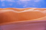
The dune
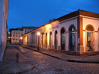
s of Lençóis are an important area of environmental preservation. Also of interest is the state capital of São Luís
, designated a Unesco World Heritage Site. Another important conservation area is the Parnaíba River
delta, between the states of Maranhão and Piauí
, with its lagoon
s, desert
dune
s and deserted beach
es or islands, such as the Caju island
, which shelters rare bird
s.
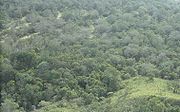
 The northern portion of the state is a heavily forested plain traversed by numerous rivers, occupied by the eastern extension of the tropical moist forests
of Amazonia. The Tocantins-Araguaia-Maranhão moist forests occupy the northwestern portion of the state, extending from the Pindaré River
west into neighboring Pará state. The north-central and northeastern portion of the state, extending eastward into northern Piauí, is home to the Maranhão Babaçu forests
, a degraded tropical moist forest ecoregion dominated by the Babaçu palm. Much of the forest has been cleared for cattle grazing and agriculture, and the Babaçu palm produces edible oil which is extracted commercially.
The southern portion of the state belong to the lower terraces of the great Brazilian Highlands
, occupied by the Cerrado
savannas. Several plateau escarpment
s, including the Chapada das Mangabeiras
, Serra do Tiracambu
, and Serra das Alpercatas, mark the state's northern margin and the outlines of river valleys.
The climate is hot, and the year is divided into a wet and dry season, extreme humidity being characteristic of the former. The heat, however, is greatly modified on the coast by the south-east trade winds.
The rivers of the state all flow northward to the Atlantic and a majority of them have navigable channels. The Gurupi River
forms the northwestern boundary of the state, separating Maranhão from neighboring Pará, and the Tocantins River
forms part the state's southwestern boundary with Tocantins state. The Parnaíba River
forms the eastern boundary of Maranhão, but it has one large tributary, the Balsas, entirely within the state. Other rivers in the state include the Turiassu (or Turiaçu) which runs just east of the Gurupi, emptying into the Baía de Turiassu; the Mearim
, Pindaré
, and Grajaú
, which empty into the Baía de São Marcos
; and the Itapecuru
and Munim
which discharge into the Baía de São José
. Like the Amazon, the Mearim has a pororoca
or tidal bore
in its lower channel, which greatly interferes with navigation.
The western coastline has many small indentations, which are usually masked by islands or shoals. The largest of these are the Baía de Turiassu, facing which is São João Island, and the contiguous bays of São Marcos and São José, between which is the large island of São Luís
. This indented shoreline is home to the Maranhão mangroves
, the tallest mangrove forests in the world. The coastline east of Baía de São José is less indented and characterized by sand dunes, including the stark dune fields of the Lençóis Maranhenses National Park
, as well as restinga
forests that form on stabilized dunes.
 The first known European to explore Maranhão was the Spanish
explorer Vicente Yáñez Pinzón
in 1500, but was granted to João de Barros
in 1534 as a Portuguese
hereditary captaincy. The first European settlement, however, was made by a French
trading expedition under Jacques Riffault, of Dieppe
, in 1594, who lost two of his three vessels in the vicinity of São Luís Island
, and left a part of his men on that island when he returned home. Subsequently Daniel de La Touche, Seigneur de La Rividière was sent to report on the place, and was then commissioned by the French crown to found a colony on the island; this was done in 1612. The French were expelled by the Portuguese in 1615, and the Dutch
held the island from 1641 to 1644. In 1621 Ceara, Maranhão and Pará were united and called the "Estado do Maranhao," which was separated from the southern captaincies. Very successful Indian missions were soon begun by the Jesuits, who were temporarily expelled as a result of a civil war in 1684 for their opposition to the enslavement of the Indians. Ceara was subsequently detached, but the "state" of Maranhao remained separate until 1774, when it again became subject to the colonial administration of Brazil.
Maranhão did not join in the Brazilian declaration of independence of 1822, but in the following year the Portuguese were driven out by British sailor and liberator Admiral Lord Cochrane
and it became part of the Empire of Brazil. For this achievement Lord Cochrane became 1st Marques of Maranhão and Governor
of the Province
of Maranhão.
São Luís is the Brazilian state capital which most closely resembles a Portuguese city. By the early 20th century São Luís has about 30,000 inhabitants, and contained several convents, charitable institutes, the episcopal palace, a fine Carmelite church, and an ecclesiastical seminary. The historic city center was declared a World Heritage Site
in 1997.
of 2008, there were 6,400,000 people residing in the state. The population density was 18.6 inh./km².
Urbanization
: 68.1% (2004); Population growth
: 1.5% (1991–2000); House
s: 1,442,500 (2005).
The last PNAD (National Research for Sample of Domiciles) census revealed the following numbers: 4,271,000 Brown (Multiracial) people (66.74%), 1,636,000 White
people (25.57%), 410,000 Black
people (6.41%), 43,000 Asian
people (0.67%), 39,000 Amerindian
people (0.60%).
represents 20.1%, of GDP (2004). Maranhão exports: aluminium
50%, iron
23.7%, soybean
13.1% (2002).
Share of the Brazilian economy: 0.9% (2004).
This State is also known as the land of the palm trees, as the various species of this tree provide its major source of income. The most important of them, from an economic point of view, is the babassu. The agribusiness, the aluminium and alumina transformation industries, and the food and timber industries complement the state economy.
is the official national language, and thus the primary language taught in schools. But English
and Spanish
are part of the official high school
curriculum.
Marechal Cunha Machado International Airport. With a covered area of 8,100 square meters and capacity of up to a million passengers a year, the airport is located 13 kilometers from the city center. In October 2004 it began receiving international flights, in response to a longstanding request from tour operators in the region. The Maranhão State Extraordinary Secretariat of Tourism has been working to attract charter flights from European countries, such as Portugal
, Italy
, Germany
and Spain
.
Renato Moreira Airport. Infraero
has administered the airport since November 3, 1980. Exactly one year later it was officially opened to traffic.
The passenger
terminal structure, initially built by COMARA, was modified and expanded in 1998, receiving improvements such as new arrival and departure areas, an expanded main concourse and air conditioning of the entire terminal. This airport is located as Imperatriz
city.
The colored strips symbolize the different ethnic groups which make up the population, and their mixing and living together. The white star in the upper left corner symbolizes Maranhão itself, and is supposed to be Beta Scorpii
, as the constellation Scorpius
is also depicted on the national flag of Brazil
. The flag has a ratio of 2:3.
Brazil
Brazil , officially the Federative Republic of Brazil , is the largest country in South America. It is the world's fifth largest country, both by geographical area and by population with over 192 million people...
. To the north lies the Atlantic Ocean
Atlantic Ocean
The Atlantic Ocean is the second-largest of the world's oceanic divisions. With a total area of about , it covers approximately 20% of the Earth's surface and about 26% of its water surface area...
. Maranhão is neighbored by the (clockwise from east) states of Piauí
Piauí
Piauí is one of the states of Brazil, located in the northeastern part of the country.Piauí has the shortest coastline of any of the non-landlocked Brazilian states at 66 km , and the capital, Teresina, is the only state capital in the north east to be located inland...
, Tocantins and Pará
Pará
Pará is a state in the north of Brazil. It borders the Brazilian states of Amapá, Maranhão, Tocantins, Mato Grosso, Amazonas and Roraima. To the northwest it also borders Guyana and Suriname, and to the northeast it borders the Atlantic Ocean. The capital is Belém.Pará is the most populous state...
. The people of Maranhão have a distinctive accent. Maranhão is described in books such as The Land of the Palm Trees, by Gonçalves Dias, and Casas de Pensão by Aluísio Azevedo
Aluísio Azevedo
Aluísio Tancredo Gonçalves de Azevedo was a Brazilian novelist, caricaturist, diplomat, playwright and short story writer. Initially a Romantic writer, he would later adhere to the Naturalist movement...
.
The dune
Dune
In physical geography, a dune is a hill of sand built by wind. Dunes occur in different forms and sizes, formed by interaction with the wind. Most kinds of dunes are longer on the windward side where the sand is pushed up the dune and have a shorter "slip face" in the lee of the wind...
s of Lençóis are an important area of environmental preservation. Also of interest is the state capital of São Luís
São Luís, Maranhão
São Luís is the capital and largest city of the Brazilian state of Maranhão. The city is located on Ilha de São Luís in the Baía de São Marcos , an extension of the Atlantic Ocean which forms the estuary of Pindaré, Mearim, Itapecuru and other rivers. Its coordinates are 2.53° south, 44.30° west...
, designated a Unesco World Heritage Site. Another important conservation area is the Parnaíba River
Parnaiba River
The Parnaíba River is a river in Brazil, which forms the border between the states of Maranhão and Piauí. The Parnaíba River rises in the Chapada das Mangabeiras range, and flows northeastward for 1,056 miles to empty into the Atlantic Ocean. The middle and upper regions of this river are...
delta, between the states of Maranhão and Piauí
Piauí
Piauí is one of the states of Brazil, located in the northeastern part of the country.Piauí has the shortest coastline of any of the non-landlocked Brazilian states at 66 km , and the capital, Teresina, is the only state capital in the north east to be located inland...
, with its lagoon
Lagoon
A lagoon is a body of shallow sea water or brackish water separated from the sea by some form of barrier. The EU's habitat directive defines lagoons as "expanses of shallow coastal salt water, of varying salinity or water volume, wholly or partially separated from the sea by sand banks or shingle,...
s, desert
Desert
A desert is a landscape or region that receives an extremely low amount of precipitation, less than enough to support growth of most plants. Most deserts have an average annual precipitation of less than...
dune
Dune
In physical geography, a dune is a hill of sand built by wind. Dunes occur in different forms and sizes, formed by interaction with the wind. Most kinds of dunes are longer on the windward side where the sand is pushed up the dune and have a shorter "slip face" in the lee of the wind...
s and deserted beach
Beach
A beach is a geological landform along the shoreline of an ocean, sea, lake or river. It usually consists of loose particles which are often composed of rock, such as sand, gravel, shingle, pebbles or cobblestones...
es or islands, such as the Caju island
Island
An island or isle is any piece of sub-continental land that is surrounded by water. Very small islands such as emergent land features on atolls can be called islets, cays or keys. An island in a river or lake may be called an eyot , or holm...
, which shelters rare bird
Bird
Birds are feathered, winged, bipedal, endothermic , egg-laying, vertebrate animals. Around 10,000 living species and 188 families makes them the most speciose class of tetrapod vertebrates. They inhabit ecosystems across the globe, from the Arctic to the Antarctic. Extant birds range in size from...
s.
Geography
Tropical and subtropical moist broadleaf forests
Tropical and subtropical moist broadleaf forests , also known as tropical moist forests, are a tropical and subtropical forest biome....
of Amazonia. The Tocantins-Araguaia-Maranhão moist forests occupy the northwestern portion of the state, extending from the Pindaré River
Pindaré River
The Pindaré River is a river in Maranhão state of north-central Brazil. The Pindaré rises in the low hills which separate its basin from that of the Tocantins River to the south, and flows north into the Baía de São Marcos...
west into neighboring Pará state. The north-central and northeastern portion of the state, extending eastward into northern Piauí, is home to the Maranhão Babaçu forests
Maranhão Babaçu forests
The Maranhão Babaçu forests is a tropical moist broadleaf forest ecoregion of north-central Brazil.-Setting:The Maranhão Babaçu forests cover an area of , extending across northeastern and central Maranhão state and northern Piauí state. The forests form a transition between the equatorial forests...
, a degraded tropical moist forest ecoregion dominated by the Babaçu palm. Much of the forest has been cleared for cattle grazing and agriculture, and the Babaçu palm produces edible oil which is extracted commercially.
The southern portion of the state belong to the lower terraces of the great Brazilian Highlands
Brazilian Highlands
The Brazilian Highlands or Brazilian Plateau are an extensive geographical region, covering most of the eastern, southern and central portions of Brazil, in all approximately half of the country's land area, or some 4,500,000 km²...
, occupied by the Cerrado
Cerrado
The Cerrado, is a vast tropical savanna ecoregion of Brazil, particularly in the states of Gioas and Minas Gerais...
savannas. Several plateau escarpment
Escarpment
An escarpment is a steep slope or long cliff that occurs from erosion or faulting and separates two relatively level areas of differing elevations.-Description and variants:...
s, including the Chapada das Mangabeiras
Chapada das Mangabeiras
The Chapada das Mangabeiras is a mountain range in central Brazil. The range runs northwest-southeast, and separates the basin of the Tocantins River to the southwest from the upper basin of the Parnaiba River to the northeast. The range also forms the boundary between Tocantins state and the...
, Serra do Tiracambu
Serra do Tiracambu
The Serra do Tiracambu is a mountain range in Maranhão state of north-central Brazil. The range runs north and south, and forms the divide between the basins of the Gurupí River to the west and the Pindaré River to the east....
, and Serra das Alpercatas, mark the state's northern margin and the outlines of river valleys.
The climate is hot, and the year is divided into a wet and dry season, extreme humidity being characteristic of the former. The heat, however, is greatly modified on the coast by the south-east trade winds.
The rivers of the state all flow northward to the Atlantic and a majority of them have navigable channels. The Gurupi River
Gurupí River
The Gurupí River is a river in north-central Brazil which forms the boundary between Maranhão and Pará states. The Gurupí rises in the low hills which separate its basin from that of the Tocantins River to the south, and flows north into the Atlantic Ocean...
forms the northwestern boundary of the state, separating Maranhão from neighboring Pará, and the Tocantins River
Tocantins River
The Tocantins is a river in Brazil, the central fluvial artery of the country. In the Tupi language, its name means "toucan's beak" . It runs from south to north for about 2,640 km. It is not really a branch of the Amazon River, although usually so considered, since its waters flow into the...
forms part the state's southwestern boundary with Tocantins state. The Parnaíba River
Parnaiba River
The Parnaíba River is a river in Brazil, which forms the border between the states of Maranhão and Piauí. The Parnaíba River rises in the Chapada das Mangabeiras range, and flows northeastward for 1,056 miles to empty into the Atlantic Ocean. The middle and upper regions of this river are...
forms the eastern boundary of Maranhão, but it has one large tributary, the Balsas, entirely within the state. Other rivers in the state include the Turiassu (or Turiaçu) which runs just east of the Gurupi, emptying into the Baía de Turiassu; the Mearim
Mearim River
The Mearim River is a river in Maranhão state of northern Brazil. The river originates in the southern part of Maranhão, and drains north into the Baía de São Marcos, an estuary that also receives the Pindaré and Grajaú rivers, which are sometimes considered tributaries of the Mearim. The lower...
, Pindaré
Pindaré River
The Pindaré River is a river in Maranhão state of north-central Brazil. The Pindaré rises in the low hills which separate its basin from that of the Tocantins River to the south, and flows north into the Baía de São Marcos...
, and Grajaú
Grajaú River
-Brazil:* Grajaú River* Grajaú River...
, which empty into the Baía de São Marcos
Baía de São Marcos
The Baía de São Marcos is a bay of the Atlantic Ocean in Maranhão state of northeastern Brazil.The bay is an estuary approximately 100 kilometers long and up to 16 kilometers wide. It receives several rivers, including the Grajaú, Mearim, and Pindaré...
; and the Itapecuru
Itapecuru River
The Itapecuru River, also known as the Itapicuru River, is a river in Maranhão state of northern Brazil. The Itapicuru originates in the southern part of the state, and flows northward to empty into the Baía de São José....
and Munim
Munim River
-References:*...
which discharge into the Baía de São José
Baía de São José
The Baía de São José is a bay of the Atlantic Ocean in Maranhão state of northeastern Brazil.The bay is an estuary which receives several rivers, including the Itapecuru and Munim....
. Like the Amazon, the Mearim has a pororoca
Pororoca
The pororoca is a tidal bore, with waves up to 4 metres high that travel as much as 13 km inland upstream on the Amazon River and adjacent rivers. Its name comes from the indigenous Tupi language, where it translates into "great destructive noise". It occurs at the mouth of the river where river...
or tidal bore
Tidal bore
A tidal bore is a tidal phenomenon in which the leading edge of the incoming tide forms a wave of water that travel up a river or narrow bay against the direction of the river or bay's current...
in its lower channel, which greatly interferes with navigation.
The western coastline has many small indentations, which are usually masked by islands or shoals. The largest of these are the Baía de Turiassu, facing which is São João Island, and the contiguous bays of São Marcos and São José, between which is the large island of São Luís
São Luís Island
São Luís Island is an island in Brazil with an area of 1,410 km² , located between the Baía de São Marcos and the Baía de São José in Maranhão state. There are 4 cities located in the island: São Luís, after which the island is named, São José de Ribamar, Paço do Lumiar, and Raposa. São Luís is the...
. This indented shoreline is home to the Maranhão mangroves
Maranhão mangroves
-Setting:The ecoregion covers and area of on the Atlantic coast of Maranhão and eastern Pará states. The ecoregion is divisible into eastern and western parts. The western part extends from near Belém on the Pará River along the coast of eastern Pará and western Maranhão states to the Baía de São...
, the tallest mangrove forests in the world. The coastline east of Baía de São José is less indented and characterized by sand dunes, including the stark dune fields of the Lençóis Maranhenses National Park
Lençóis Maranhenses National Park
The Lençóis Maranhenses National Park is located in Maranhão state, in northeastern Brazil, just east of the Baía de São José, between 02º19’—02º45’ S and 42º44’—43º29’ W. It is an area of low, flat, occasionally flooded land, overlaid with large, discrete sand dunes...
, as well as restinga
Restinga
Restinga is a municipality in the state of São Paulo in Brazil. The population in 2004 was 6,188 and the area is 246.37 km². The elevation is 910 m....
forests that form on stabilized dunes.
History
Spain
Spain , officially the Kingdom of Spain languages]] under the European Charter for Regional or Minority Languages. In each of these, Spain's official name is as follows:;;;;;;), is a country and member state of the European Union located in southwestern Europe on the Iberian Peninsula...
explorer Vicente Yáñez Pinzón
Vicente Yáñez Pinzón
Vicente Yáñez Pinzón was a Spanish navigator, explorer, and conquistador, the youngest of the Pinzón brothers...
in 1500, but was granted to João de Barros
João de Barros
João de Barros , called the Portuguese Livy, is one of the first great Portuguese historians, most famous for his Décadas da Ásia , a history of the Portuguese in India and Asia.-Early years:...
in 1534 as a Portuguese
Portugal
Portugal , officially the Portuguese Republic is a country situated in southwestern Europe on the Iberian Peninsula. Portugal is the westernmost country of Europe, and is bordered by the Atlantic Ocean to the West and South and by Spain to the North and East. The Atlantic archipelagos of the...
hereditary captaincy. The first European settlement, however, was made by a French
France
The French Republic , The French Republic , The French Republic , (commonly known as France , is a unitary semi-presidential republic in Western Europe with several overseas territories and islands located on other continents and in the Indian, Pacific, and Atlantic oceans. Metropolitan France...
trading expedition under Jacques Riffault, of Dieppe
Dieppe, Seine-Maritime
Dieppe is a commune in the Seine-Maritime department in France. In 1999, the population of the whole Dieppe urban area was 81,419.A port on the English Channel, famous for its scallops, and with a regular ferry service from the Gare Maritime to Newhaven in England, Dieppe also has a popular pebbled...
, in 1594, who lost two of his three vessels in the vicinity of São Luís Island
São Luís Island
São Luís Island is an island in Brazil with an area of 1,410 km² , located between the Baía de São Marcos and the Baía de São José in Maranhão state. There are 4 cities located in the island: São Luís, after which the island is named, São José de Ribamar, Paço do Lumiar, and Raposa. São Luís is the...
, and left a part of his men on that island when he returned home. Subsequently Daniel de La Touche, Seigneur de La Rividière was sent to report on the place, and was then commissioned by the French crown to found a colony on the island; this was done in 1612. The French were expelled by the Portuguese in 1615, and the Dutch
Netherlands
The Netherlands is a constituent country of the Kingdom of the Netherlands, located mainly in North-West Europe and with several islands in the Caribbean. Mainland Netherlands borders the North Sea to the north and west, Belgium to the south, and Germany to the east, and shares maritime borders...
held the island from 1641 to 1644. In 1621 Ceara, Maranhão and Pará were united and called the "Estado do Maranhao," which was separated from the southern captaincies. Very successful Indian missions were soon begun by the Jesuits, who were temporarily expelled as a result of a civil war in 1684 for their opposition to the enslavement of the Indians. Ceara was subsequently detached, but the "state" of Maranhao remained separate until 1774, when it again became subject to the colonial administration of Brazil.
Maranhão did not join in the Brazilian declaration of independence of 1822, but in the following year the Portuguese were driven out by British sailor and liberator Admiral Lord Cochrane
Thomas Cochrane, 10th Earl of Dundonald
Admiral Thomas Cochrane, 10th Earl of Dundonald, 1st Marquess of Maranhão, GCB, ODM , styled Lord Cochrane between 1778 and 1831, was a senior British naval flag officer and radical politician....
and it became part of the Empire of Brazil. For this achievement Lord Cochrane became 1st Marques of Maranhão and Governor
Governor
A governor is a governing official, usually the executive of a non-sovereign level of government, ranking under the head of state...
of the Province
Province
A province is a territorial unit, almost always an administrative division, within a country or state.-Etymology:The English word "province" is attested since about 1330 and derives from the 13th-century Old French "province," which itself comes from the Latin word "provincia," which referred to...
of Maranhão.
São Luís is the Brazilian state capital which most closely resembles a Portuguese city. By the early 20th century São Luís has about 30,000 inhabitants, and contained several convents, charitable institutes, the episcopal palace, a fine Carmelite church, and an ecclesiastical seminary. The historic city center was declared a World Heritage Site
World Heritage Site
A UNESCO World Heritage Site is a place that is listed by the UNESCO as of special cultural or physical significance...
in 1997.
Demographics
According to the IBGEIBGE
The Brazilian Institute of Geography and Statistics or IBGE , is the agency responsible for statistical, geographic, cartographic, geodetic and environmental information in Brazil...
of 2008, there were 6,400,000 people residing in the state. The population density was 18.6 inh./km².
Urbanization
Urbanization
Urbanization, urbanisation or urban drift is the physical growth of urban areas as a result of global change. The United Nations projected that half of the world's population would live in urban areas at the end of 2008....
: 68.1% (2004); Population growth
Population growth
Population growth is the change in a population over time, and can be quantified as the change in the number of individuals of any species in a population using "per unit time" for measurement....
: 1.5% (1991–2000); House
House
A house is a building or structure that has the ability to be occupied for dwelling by human beings or other creatures. The term house includes many kinds of different dwellings ranging from rudimentary huts of nomadic tribes to free standing individual structures...
s: 1,442,500 (2005).
The last PNAD (National Research for Sample of Domiciles) census revealed the following numbers: 4,271,000 Brown (Multiracial) people (66.74%), 1,636,000 White
White Brazilian
White Brazilians make up 48.4% of Brazil's population, or around 92 million people, according to the IBGE's 2008 PNAD . Whites are present in the entire territory of Brazil, although the main concentrations are found in the South and Southeastern parts of the country...
people (25.57%), 410,000 Black
Afro-Brazilian
In Brazil, the term "preto" is one of the five categories used by the Brazilian Census, along with "branco" , "pardo" , "amarelo" and "indígena"...
people (6.41%), 43,000 Asian
Asian Brazilian
An Asian Brazilian is is a Brazilian citizen of full or partial Asian ancestry, who remains culturally connected to Asia, or an Asian-born person permanently residing in Brazil. Brazil received many immigrants from Asia, both from Middle East and East Asia...
people (0.67%), 39,000 Amerindian
Indigenous peoples in Brazil
The Indigenous peoples in Brazil comprise a large number of distinct ethnic groups who inhabited the country prior to the European invasion around 1500...
people (0.60%).
Economy
Maranhão is one of the poorest states of Brazil. The service sector is the largest component of GDP at 54.5%, followed by the industrial sector at 25.4%. AgricultureAgriculture
Agriculture is the cultivation of animals, plants, fungi and other life forms for food, fiber, and other products used to sustain life. Agriculture was the key implement in the rise of sedentary human civilization, whereby farming of domesticated species created food surpluses that nurtured the...
represents 20.1%, of GDP (2004). Maranhão exports: aluminium
Aluminium
Aluminium or aluminum is a silvery white member of the boron group of chemical elements. It has the symbol Al, and its atomic number is 13. It is not soluble in water under normal circumstances....
50%, iron
Iron
Iron is a chemical element with the symbol Fe and atomic number 26. It is a metal in the first transition series. It is the most common element forming the planet Earth as a whole, forming much of Earth's outer and inner core. It is the fourth most common element in the Earth's crust...
23.7%, soybean
Soybean
The soybean or soya bean is a species of legume native to East Asia, widely grown for its edible bean which has numerous uses...
13.1% (2002).
Share of the Brazilian economy: 0.9% (2004).
This State is also known as the land of the palm trees, as the various species of this tree provide its major source of income. The most important of them, from an economic point of view, is the babassu. The agribusiness, the aluminium and alumina transformation industries, and the food and timber industries complement the state economy.
Education
PortuguesePortuguese language
Portuguese is a Romance language that arose in the medieval Kingdom of Galicia, nowadays Galicia and Northern Portugal. The southern part of the Kingdom of Galicia became independent as the County of Portugal in 1095...
is the official national language, and thus the primary language taught in schools. But English
English language
English is a West Germanic language that arose in the Anglo-Saxon kingdoms of England and spread into what was to become south-east Scotland under the influence of the Anglian medieval kingdom of Northumbria...
and Spanish
Spanish language
Spanish , also known as Castilian , is a Romance language in the Ibero-Romance group that evolved from several languages and dialects in central-northern Iberia around the 9th century and gradually spread with the expansion of the Kingdom of Castile into central and southern Iberia during the...
are part of the official high school
High school
High school is a term used in parts of the English speaking world to describe institutions which provide all or part of secondary education. The term is often incorporated into the name of such institutions....
curriculum.
Educational institutions
- Universidade Federal do Maranhão (UFMA) (Federal University of Maranhão) www.ufma.br;
- Universidade Estadual do Maranhão (UEMA) (State University of Maranhão) www.uema.br;
- Centro Universitário do Maranhão (UNICEUMA) (University Center of Maranhão) www.ceuma.br;
- Unidade de Ensino Superior do Sul do Maranhão (UNISULMA);
- Unidade de Ensino Superior Dom Bosco (UNDB);
- Centro Federal de Educação Tecnológica do Maranhão (CEFET-MA);
- and many others.
International Airport
- São Luís
Marechal Cunha Machado International Airport. With a covered area of 8,100 square meters and capacity of up to a million passengers a year, the airport is located 13 kilometers from the city center. In October 2004 it began receiving international flights, in response to a longstanding request from tour operators in the region. The Maranhão State Extraordinary Secretariat of Tourism has been working to attract charter flights from European countries, such as Portugal
Portugal
Portugal , officially the Portuguese Republic is a country situated in southwestern Europe on the Iberian Peninsula. Portugal is the westernmost country of Europe, and is bordered by the Atlantic Ocean to the West and South and by Spain to the North and East. The Atlantic archipelagos of the...
, Italy
Italy
Italy , officially the Italian Republic languages]] under the European Charter for Regional or Minority Languages. In each of these, Italy's official name is as follows:;;;;;;;;), is a unitary parliamentary republic in South-Central Europe. To the north it borders France, Switzerland, Austria and...
, Germany
Germany
Germany , officially the Federal Republic of Germany , is a federal parliamentary republic in Europe. The country consists of 16 states while the capital and largest city is Berlin. Germany covers an area of 357,021 km2 and has a largely temperate seasonal climate...
and Spain
Spain
Spain , officially the Kingdom of Spain languages]] under the European Charter for Regional or Minority Languages. In each of these, Spain's official name is as follows:;;;;;;), is a country and member state of the European Union located in southwestern Europe on the Iberian Peninsula...
.
National airport
- ImperatrizImperatrizImperatriz is the second most populated city in the Brazilian state of Maranhão. The city extends along the right bank of the Tocantins River and is crossed by the Belém-Brasília Highway, standing on the border with the state of Tocantins....
Renato Moreira Airport. Infraero
Infraero
Empresa Brasileira de Infraestrutura Aeroportuária, Infraero in short, is a Brazilian government corporation created in 1972 and responsible for operating the main Brazilian commercial airports. In 2009, Infraero's airports carried 128,135,616 passengers and 1,114,754 tons of cargo and operated...
has administered the airport since November 3, 1980. Exactly one year later it was officially opened to traffic.
The passenger
Passenger
A passenger is a term broadly used to describe any person who travels in a vehicle, but bears little or no responsibility for the tasks required for that vehicle to arrive at its destination....
terminal structure, initially built by COMARA, was modified and expanded in 1998, receiving improvements such as new arrival and departure areas, an expanded main concourse and air conditioning of the entire terminal. This airport is located as Imperatriz
Imperatriz
Imperatriz is the second most populated city in the Brazilian state of Maranhão. The city extends along the right bank of the Tocantins River and is crossed by the Belém-Brasília Highway, standing on the border with the state of Tocantins....
city.
Flag
The flag of Maranhão was designed by the poet Joaquim de Souza Andrade, and was adopted by decree nr. 6, of December 21, 1889.The colored strips symbolize the different ethnic groups which make up the population, and their mixing and living together. The white star in the upper left corner symbolizes Maranhão itself, and is supposed to be Beta Scorpii
Beta Scorpii
Beta Scorpii is a star system in the constellation Scorpius. It has the traditional names Acrab, Akrab or Elacrab, all come from al-'Aqrab, the Scorpion, for the whole constellation, as well as Graffias, a name it shares with Xi Scorpii...
, as the constellation Scorpius
Scorpius
Scorpius, sometimes known as Scorpio, is one of the constellations of the zodiac. Its name is Latin for scorpion, and its symbol is . It lies between Libra to the west and Sagittarius to the east...
is also depicted on the national flag of Brazil
Flag of Brazil
The national flag of Brazil is a blue disc depicting a starry sky spanned by a curved band inscribed with the national motto, within a yellow rhombus, on a green field. Brazil officially adopted this design for its national flag on November 19, 1889, replacing the flag of the second Empire of Brazil...
. The flag has a ratio of 2:3.
Portrayals in film
- Andrucha WaddingtonAndrucha WaddingtonAndrucha Waddington is a Brazilian film director, producer and screenwriter. He has directed eleven films since 1998. His film Eu Tu Eles was screened in the Un Certain Regard section at the 2000 Cannes Film Festival.-Filmography:...
's The House of SandThe House of SandThe House of Sand is a 2005 Brazilian film directed by Andrucha Waddington. It stars real life mother and daughter Fernanda Montenegro and Fernanda Torres...
(Casa de Areia, 2005) prominently features the sand dunes of Maranhão. - Carla Camurati's Carlota Joaquina, Princess of Brazil (1995) was filmed in the historical center of São Luís, a UNESCO World Heritage Site.
- The song Kadhal AnukkalKadhal Anukkal"Kadhal Anukkal" is a Tamil song from the 2010 film Enthiran, directed by S. Shankar. The song was composed by A. R. Rahman, sung by Vijay Prakash, Shreya Ghoshal and lyrics written by Vairamuthu. The Hindi and Telugu version of the song are titled "Pagal Anukkan" and "Neelo Valapu" and written by...
from Endhiran (Tamil, 2010) featuring Aishwarya Rai and Rajnikanth was completely and beautifully shot at the Lençóis Maranhenses National Park sand dunes.