
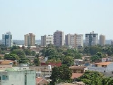
Porto Velho
Encyclopedia
Porto Velho (ˈpoʁtu ˈvɛʎu, Old Port) is the capital of the Brazil
ian state of Rondônia
, in the upper Amazon River
basin. The population is estimated to be 426,558 people (IBGE
/2010). Located on the border
of Rondônia and the state of Amazonas, the town is an important trading center for cassiterite
, the mining of which represents the most important economic activity in the region
, as well as a transportation and communication center. It is located on the eastern shore of the Madeira River
, one of the main tributaries
of the Amazon River
. It is also Rondônia's largest city.
The municipality occupies most of the border between Amazonas and Rondônia, and is simultaneously the westernmost and northernmost city in the state.
. After the railroad was completed, the local population was about one thousand inhabitants; its buildings were chiefly the railway's installations and the wooden houses of the Caribbean
workers - hence the name of the town's largest district by then, "Barbados Town", nowadays called the "Alto do Bode".
During the first sixty years, the city's development
was directly connected to the railway's activities. The town prospered during the rubber boom, but then when low-cost Malaysian rubber made rubber from the Amazon
uncompetitive, the region's economy
ground to a halt. Cities like Santo Antônio do Madeira, which had a tram
line and a weekly newspaper
by the time of Porto Velho's foundation, are nothing but ruins nowadays.
Porto Velho's survival is associated with the better conditions of the area where it was built, its easy access by the river and its harbor: these were all considerations in the choice of Porto Velho as the capital of the newly formed Federal Territory of Guaporé, in 1943. Only with the beginning of World War II
was there another cycle of progress in the region. When the Allied forces
lost control over the Malaysian rubber, Amazon's was needed due to the war effort
. This produced what is known in Brazil as the "second rubber boom
". But when the war ended, the region's economy once again came to a halt.
Porto Velho's modern history
begins with the discovery of cassiterite
around the city, and of gold
on the Madeira River
, at the end of the 1950s. In addition, the government's decision to allow large cattle farms in the territory began a trend of migration into the city. Almost one million people moved to Rondônia, and Porto Velho's population increased to three hundred thousand. This intense migration caused much trouble for the city. Among many other problems, the suburban boroughs, for example, are nothing but shanty town
s.
in which there is no dry season
– all months have mean precipitation
values of at least 60 mm. It is usually found at latitude
s within five degrees of the equator
– which are dominated by the Intertropical Convergence Zone
. The equatorial climate is denoted Af in the Köppen climate classification
. Tropical rainforest
is the natural vegetation in equatorial regions.
s and comprises the largest and most species-rich tract of tropical rainforest
in the world
. Wet tropical forests are the most species-rich biome
, and tropical forests in the Americas
are consistently more species rich than the wet
forests in Africa
and Asia
.
As the largest tract of tropical rainforest in the Americas, the Amazonian rainforests have unparalleled biodiversity
.
More than 1/3 of all species in the world live in the Amazon Rainforest.
The per capita income
for the city was R$ 9,779 (2005).

, located seven kilometers from the city, has as its main access at the Av. Governador Jorge Teixeira de Oliveira, with two lanes. Buses from downtown run to the airport every hour, and there is a fleet of taxis serving only the airport. The airport is served by 98 scheduled flights weekly, most going to other large Brazilian cities. The presence of Porto Velho Air Force Base
ensures considerable movement of military aircraft. The local people refer to Porto Velho International as Belmont Airport because it is located in this district. It became an international airport in 2002. It was built as a replacement to Caiari Airport
, which was closed on April 16, 1969.
 Portuguese
is the official national language, and thus the primary language taught in schools. But English
and Spanish
are part of the official high school
curriculum.

) and Teatro Uirassu Rodrigues, in José Bonifácio street
.
Brazil
Brazil , officially the Federative Republic of Brazil , is the largest country in South America. It is the world's fifth largest country, both by geographical area and by population with over 192 million people...
ian state of Rondônia
Rondônia
Rondônia is a state in Brazil, located in the north-western part of the country. To the west is a short border with the state of Acre, to the north is the state of Amazonas, in the east is Mato Grosso, and in the south is Bolivia. Its capital is Porto Velho. The state was named after Candido Rondon...
, in the upper Amazon River
Amazon River
The Amazon of South America is the second longest river in the world and by far the largest by waterflow with an average discharge greater than the next seven largest rivers combined...
basin. The population is estimated to be 426,558 people (IBGE
IBGE
The Brazilian Institute of Geography and Statistics or IBGE , is the agency responsible for statistical, geographic, cartographic, geodetic and environmental information in Brazil...
/2010). Located on the border
Border
Borders define geographic boundaries of political entities or legal jurisdictions, such as governments, sovereign states, federated states and other subnational entities. Some borders—such as a state's internal administrative borders, or inter-state borders within the Schengen Area—are open and...
of Rondônia and the state of Amazonas, the town is an important trading center for cassiterite
Cassiterite
Cassiterite is a tin oxide mineral, SnO2. It is generally opaque, but it is translucent in thin crystals. Its luster and multiple crystal faces produce a desirable gem...
, the mining of which represents the most important economic activity in the region
Region
Region is most commonly found as a term used in terrestrial and astrophysics sciences also an area, notably among the different sub-disciplines of geography, studied by regional geographers. Regions consist of subregions that contain clusters of like areas that are distinctive by their uniformity...
, as well as a transportation and communication center. It is located on the eastern shore of the Madeira River
Madeira River
The Madeira River is a major waterway in South America, approximately 3,250 km miles long The Madeira is the biggest tributary of the Amazon...
, one of the main tributaries
Tributary
A tributary or affluent is a stream or river that flows into a main stem river or a lake. A tributary does not flow directly into a sea or ocean...
of the Amazon River
Amazon River
The Amazon of South America is the second longest river in the world and by far the largest by waterflow with an average discharge greater than the next seven largest rivers combined...
. It is also Rondônia's largest city.
The municipality occupies most of the border between Amazonas and Rondônia, and is simultaneously the westernmost and northernmost city in the state.
History
Officially founded on October 2, 1914, Porto Velho was founded by pioneers around 1907, during the construction of the Madeira-Mamoré RailroadMadeira-Mamoré Railroad
The Madira-Mamoré Railroad is a railroad built in the Brazilian state of Rondonia between 1907 and 1912. The railroad links the Brazilian cities of Porto Velho and Guajará-Mirim. It became known as the "Devil's Rail-road" because thousands of construction workers died from tropical diseases and...
. After the railroad was completed, the local population was about one thousand inhabitants; its buildings were chiefly the railway's installations and the wooden houses of the Caribbean
Caribbean Brazilian
Caribbean Brazilian is a Brazilian person of full, partial, or predominantly Caribbean ancestry, or a Caribbean-born person residing in Brazil. Many Caribbean Brazilians are of Barbadian descent.-Migration history:...
workers - hence the name of the town's largest district by then, "Barbados Town", nowadays called the "Alto do Bode".
During the first sixty years, the city's development
Urban planning
Urban planning incorporates areas such as economics, design, ecology, sociology, geography, law, political science, and statistics to guide and ensure the orderly development of settlements and communities....
was directly connected to the railway's activities. The town prospered during the rubber boom, but then when low-cost Malaysian rubber made rubber from the Amazon
Amazon Basin
The Amazon Basin is the part of South America drained by the Amazon River and its tributaries that drains an area of about , or roughly 40 percent of South America. The basin is located in the countries of Bolivia, Brazil, Colombia, Ecuador, Guyana, Peru, and Venezuela...
uncompetitive, the region's economy
Economics
Economics is the social science that analyzes the production, distribution, and consumption of goods and services. The term economics comes from the Ancient Greek from + , hence "rules of the house"...
ground to a halt. Cities like Santo Antônio do Madeira, which had a tram
Tram
A tram is a passenger rail vehicle which runs on tracks along public urban streets and also sometimes on separate rights of way. It may also run between cities and/or towns , and/or partially grade separated even in the cities...
line and a weekly newspaper
Newspaper
A newspaper is a scheduled publication containing news of current events, informative articles, diverse features and advertising. It usually is printed on relatively inexpensive, low-grade paper such as newsprint. By 2007, there were 6580 daily newspapers in the world selling 395 million copies a...
by the time of Porto Velho's foundation, are nothing but ruins nowadays.
Porto Velho's survival is associated with the better conditions of the area where it was built, its easy access by the river and its harbor: these were all considerations in the choice of Porto Velho as the capital of the newly formed Federal Territory of Guaporé, in 1943. Only with the beginning of World War II
World War II
World War II, or the Second World War , was a global conflict lasting from 1939 to 1945, involving most of the world's nations—including all of the great powers—eventually forming two opposing military alliances: the Allies and the Axis...
was there another cycle of progress in the region. When the Allied forces
Allies of World War II
The Allies of World War II were the countries that opposed the Axis powers during the Second World War . Former Axis states contributing to the Allied victory are not considered Allied states...
lost control over the Malaysian rubber, Amazon's was needed due to the war effort
War effort
In politics and military planning, a war effort refers to a coordinated mobilization of society's resources—both industrial and human—towards the support of a military force...
. This produced what is known in Brazil as the "second rubber boom
Rubber boom
The rubber boom was an important part of the economic and social history of Brazil and Amazonian regions of neighboring countries, being related with the extraction and commercialization of rubber...
". But when the war ended, the region's economy once again came to a halt.
Porto Velho's modern history
History
History is the discovery, collection, organization, and presentation of information about past events. History can also mean the period of time after writing was invented. Scholars who write about history are called historians...
begins with the discovery of cassiterite
Cassiterite
Cassiterite is a tin oxide mineral, SnO2. It is generally opaque, but it is translucent in thin crystals. Its luster and multiple crystal faces produce a desirable gem...
around the city, and of gold
Gold
Gold is a chemical element with the symbol Au and an atomic number of 79. Gold is a dense, soft, shiny, malleable and ductile metal. Pure gold has a bright yellow color and luster traditionally considered attractive, which it maintains without oxidizing in air or water. Chemically, gold is a...
on the Madeira River
Madeira River
The Madeira River is a major waterway in South America, approximately 3,250 km miles long The Madeira is the biggest tributary of the Amazon...
, at the end of the 1950s. In addition, the government's decision to allow large cattle farms in the territory began a trend of migration into the city. Almost one million people moved to Rondônia, and Porto Velho's population increased to three hundred thousand. This intense migration caused much trouble for the city. Among many other problems, the suburban boroughs, for example, are nothing but shanty town
Shanty town
A shanty town is a slum settlement of impoverished people who live in improvised dwellings made from scrap materials: often plywood, corrugated metal and sheets of plastic...
s.
Geography
Climate
An equatorial climate is a type of tropical climateTropical climate
A tropical climate is a climate of the tropics. In the Köppen climate classification it is a non-arid climate in which all twelve months have mean temperatures above...
in which there is no dry season
Dry season
The dry season is a term commonly used when describing the weather in the tropics. The weather in the tropics is dominated by the tropical rain belt, which oscillates from the northern to the southern tropics over the course of the year...
– all months have mean precipitation
Precipitation (meteorology)
In meteorology, precipitation In meteorology, precipitation In meteorology, precipitation (also known as one of the classes of hydrometeors, which are atmospheric water phenomena is any product of the condensation of atmospheric water vapor that falls under gravity. The main forms of precipitation...
values of at least 60 mm. It is usually found at latitude
Latitude
In geography, the latitude of a location on the Earth is the angular distance of that location south or north of the Equator. The latitude is an angle, and is usually measured in degrees . The equator has a latitude of 0°, the North pole has a latitude of 90° north , and the South pole has a...
s within five degrees of the equator
Equator
An equator is the intersection of a sphere's surface with the plane perpendicular to the sphere's axis of rotation and containing the sphere's center of mass....
– which are dominated by the Intertropical Convergence Zone
Intertropical Convergence Zone
The Intertropical Convergence Zone , known by sailors as The Doldrums, is the area encircling the earth near the equator where winds originating in the northern and southern hemispheres come together....
. The equatorial climate is denoted Af in the Köppen climate classification
Köppen climate classification
The Köppen climate classification is one of the most widely used climate classification systems. It was first published by Crimea German climatologist Wladimir Köppen in 1884, with several later modifications by Köppen himself, notably in 1918 and 1936...
. Tropical rainforest
Tropical rainforest
A tropical rainforest is an ecosystem type that occurs roughly within the latitudes 28 degrees north or south of the equator . This ecosystem experiences high average temperatures and a significant amount of rainfall...
is the natural vegetation in equatorial regions.
Vegetation
The Amazon represents over half of the planet's remaining rainforestRainforest
Rainforests are forests characterized by high rainfall, with definitions based on a minimum normal annual rainfall of 1750-2000 mm...
s and comprises the largest and most species-rich tract of tropical rainforest
Tropical rainforest
A tropical rainforest is an ecosystem type that occurs roughly within the latitudes 28 degrees north or south of the equator . This ecosystem experiences high average temperatures and a significant amount of rainfall...
in the world
World
World is a common name for the whole of human civilization, specifically human experience, history, or the human condition in general, worldwide, i.e. anywhere on Earth....
. Wet tropical forests are the most species-rich biome
Biome
Biomes are climatically and geographically defined as similar climatic conditions on the Earth, such as communities of plants, animals, and soil organisms, and are often referred to as ecosystems. Some parts of the earth have more or less the same kind of abiotic and biotic factors spread over a...
, and tropical forests in the Americas
Americas
The Americas, or America , are lands in the Western hemisphere, also known as the New World. In English, the plural form the Americas is often used to refer to the landmasses of North America and South America with their associated islands and regions, while the singular form America is primarily...
are consistently more species rich than the wet
forests in Africa
Africa
Africa is the world's second largest and second most populous continent, after Asia. At about 30.2 million km² including adjacent islands, it covers 6% of the Earth's total surface area and 20.4% of the total land area...
and Asia
Asia
Asia is the world's largest and most populous continent, located primarily in the eastern and northern hemispheres. It covers 8.7% of the Earth's total surface area and with approximately 3.879 billion people, it hosts 60% of the world's current human population...
.
As the largest tract of tropical rainforest in the Americas, the Amazonian rainforests have unparalleled biodiversity
Biodiversity
Biodiversity is the degree of variation of life forms within a given ecosystem, biome, or an entire planet. Biodiversity is a measure of the health of ecosystems. Biodiversity is in part a function of climate. In terrestrial habitats, tropical regions are typically rich whereas polar regions...
.
More than 1/3 of all species in the world live in the Amazon Rainforest.
Economy
The GDP for the city was R$ 3,656,512,000 (2005).The per capita income
Per capita income
Per capita income or income per person is a measure of mean income within an economic aggregate, such as a country or city. It is calculated by taking a measure of all sources of income in the aggregate and dividing it by the total population...
for the city was R$ 9,779 (2005).
Cityscape
Infrastructure
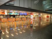
International Airport
Porto Velho International AirportGovernador Jorge Teixeira de Oliveira International Airport
Porto Velho-Governador Jorge Teixeira de Oliveira International Airport also called Belmonte Airport referring to the neighborhood where it is located, is the airport serving Porto Velho, Brazil...
, located seven kilometers from the city, has as its main access at the Av. Governador Jorge Teixeira de Oliveira, with two lanes. Buses from downtown run to the airport every hour, and there is a fleet of taxis serving only the airport. The airport is served by 98 scheduled flights weekly, most going to other large Brazilian cities. The presence of Porto Velho Air Force Base
Porto Velho Air Force Base
Porto Velho Air Force Base – BAPV is a base of the Brazilian Air Force, located in Porto Velho, Brazil.It shares some facilities shared with Porto Velho-Governador Jorge Teixeira de Oliveira International Airport.-Units:...
ensures considerable movement of military aircraft. The local people refer to Porto Velho International as Belmont Airport because it is located in this district. It became an international airport in 2002. It was built as a replacement to Caiari Airport
Caiari Airport
Caiari Airport, formerly , was the airport that served Porto Velho, Brazil until 1969, when Governador Jorge Teixeira de Oliveira International Airport was opened. On that very occasion the airport was closed.-History:...
, which was closed on April 16, 1969.
Highways
- BR-174;
- BR-317;
- BR-319;
- BR-364;
- BR-421;
- BR-425;
- BR-429;
- RO-010;
- RO-101;
- RO-490.
Education
Portuguese language
Portuguese is a Romance language that arose in the medieval Kingdom of Galicia, nowadays Galicia and Northern Portugal. The southern part of the Kingdom of Galicia became independent as the County of Portugal in 1095...
is the official national language, and thus the primary language taught in schools. But English
English language
English is a West Germanic language that arose in the Anglo-Saxon kingdoms of England and spread into what was to become south-east Scotland under the influence of the Anglian medieval kingdom of Northumbria...
and Spanish
Spanish language
Spanish , also known as Castilian , is a Romance language in the Ibero-Romance group that evolved from several languages and dialects in central-northern Iberia around the 9th century and gradually spread with the expansion of the Kingdom of Castile into central and southern Iberia during the...
are part of the official high school
High school
High school is a term used in parts of the English speaking world to describe institutions which provide all or part of secondary education. The term is often incorporated into the name of such institutions....
curriculum.
Well-known Colleges
- Universidade Federal de Rondônia (Unir);
- Instituto Luterano de Ensino Superior de Porto Velho (Iles-Ulbra);
- Faculdade Interamericana de Porto Velho (Uniron);
- Faculdade de Ciências Administrativas e de Tecnologia (Fatec-RO);
- Faculdade de Ciências Humanas, Exatas e Letras de Rondônia (Faro);
- Faculdade da Amazônia (Iesa);
- Faculdade de Porto Velho/ Fundação Getúlio Vargas (FIP/FGV);
- Faculdades Integradas Maria Coelho Aguiar (FIMCA);
- Faculdade São Lucas;
Well-known Schools
- Classe A;
- Colégio Objetivo;
- Escola Estadual de Ensino Fundamental e Médio João Bento da Costa;
- Colégio Tiradentes da Polícia Militar;
- Centro de Ensino Mineiro;
- Proensino;
- Instituto Laura Vicuña;
- Instituto Estadual de Educação Carmela Dutra;
Culture
Theatre
Teatro Municipal, in Joaquim Nabuco Avenue (DowntownDowntown
Downtown is a term primarily used in North America by English speakers to refer to a city's core or central business district ....
) and Teatro Uirassu Rodrigues, in José Bonifácio street
Street
A street is a paved public thoroughfare in a built environment. It is a public parcel of land adjoining buildings in an urban context, on which people may freely assemble, interact, and move about. A street can be as simple as a level patch of dirt, but is more often paved with a hard, durable...
.