

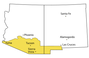
Southern Arizona
Encyclopedia
United States
The United States of America is a federal constitutional republic comprising fifty states and a federal district...
comprising the southernmost portion of the State of Arizona. It sometimes goes by the name Baja Arizona, which means "Lower Arizona" in Spanish.
Geography
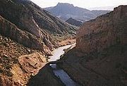
Gila River
The Gila River is a tributary of the Colorado River, 650 miles long, in the southwestern states of New Mexico and Arizona.-Description:...
but sometimes only Cochise County
Cochise County, Arizona
-2010:Whereas according to the 2010 U.S. Census Bureau:*78.5% White*4.2% Black*1.2% Native American*1.9% Asian*0.3% Native Hawaiian or Pacific Islander*4.0% Two or more races*9.6% Other races*32.4% Hispanic or Latino -2000:...
, Pima County
Pima County, Arizona
-2010:Whereas according to the 2010 U.S. Census Bureau:*74.3% White*3.5% Black*3.3% Native American*2.6% Asian*0.2% Native Hawaiian or Pacific Islander*3.7% Two or more races*12.4% Other races*34.6% Hispanic or Latino -2000:...
and Santa Cruz County
Santa Cruz County, Arizona
-2010:Whereas according to the 2010 U.S. Census Bureau:*73.5% White*0.4% Black*0.7% Native American*0.5% Asian*0.0% Native Hawaiian or Pacific Islander*2.0% Two or more races*22.9% Other races*82.8% Hispanic or Latino -2000:...
, anchored by the city of Tucson
Tucson, Arizona
Tucson is a city in and the county seat of Pima County, Arizona, United States. The city is located 118 miles southeast of Phoenix and 60 miles north of the U.S.-Mexico border. The 2010 United States Census puts the city's population at 520,116 with a metropolitan area population at 1,020,200...
. Other cities and large towns in Southern Arizona include Ajo
Ajo, Arizona
Ajo is a census-designated place in Pima County, Arizona, United States. The population was 3,705 at the 2000 census. Ajo is located on State Route 85 just from the Mexican border. It is the closest community to Organ Pipe Cactus National Monument....
, Casa Grande
Casa Grande, Arizona
Casa Grande is a city in Pinal County, approximately halfway between Phoenix and Tucson in the U.S. state of Arizona. According to 2010 Census, the population of the city is 48,571...
, Gila Bend
Gila Bend, Arizona
Gila Bend , founded in 1872, is a town in Maricopa County, Arizona, United States. The town is named for an approximately 90-degree bend in the Gila River, which is close to but not precisely at the community's current location...
, Sierra Vista
Sierra Vista, Arizona
Sierra Vista is a city in Cochise County, Arizona, United States. According to 2007 Census Bureau estimates, the population of the city is 43,044....
, Yuma
Yuma, Arizona
Yuma is a city in and the county seat of Yuma County, Arizona, United States. It is located in the southwestern corner of the state, and the population of the city was 77,515 at the 2000 census, with a 2008 Census Bureau estimated population of 90,041....
, and the border cities of Nogales
Nogales, Arizona
Nogales is a city in Santa Cruz County, Arizona, United States. The population was 21,017 at the 2010 census. According to 2005 Census Bureau estimates, the population of the city is 20,833. The city is the county seat of Santa Cruz County....
and Douglas
Douglas, Arizona
Douglas is a city in Cochise County, Arizona, United States. Douglas has a border crossing with Mexico and a history of mining.The population was 14,312 at the 2000 census...
Furthermore, the populated areas of Southern Arizona include the major U.S. Army post of Fort Huachuca
Fort Huachuca
Fort Huachuca is a United States Army installation under the command of the United States Army Installation Management Command. It is located in Cochise County, in southeast Arizona, about north of the border with Mexico. Beginning in 1913, for 20 years the fort was the base for the "Buffalo...
and Davis-Monthan Air Force Base
Davis-Monthan Air Force Base
Davis–Monthan Air Force Base is a United States Air Force base located within the city limits, and approximately south-southeast of downtown, Tucson, Arizona....
of the U.S. Air Force.
The most major scientific site of Southern Arizona is the set of several astronomical observatories of the Kitt Peak National Observatory
Kitt Peak National Observatory
The Kitt Peak National Observatory is a United States astronomical observatory located on 2,096 m Kitt Peak of the Quinlan Mountains in the Arizona-Sonoran Desert on the Tohono O'odham Nation, southwest of Tucson...
, a reasonable distance west-southwest of Tucson.
Southern Arizona is the location of several large National Monuments protecting the scenery, wildlife, and archaeological site
Archaeological site
An archaeological site is a place in which evidence of past activity is preserved , and which has been, or may be, investigated using the discipline of archaeology and represents a part of the archaeological record.Beyond this, the definition and geographical extent of a 'site' can vary widely,...
s of Southern Arizona, and the Saguaro National Park
Saguaro National Park
Saguaro National Park, located in southern Arizona, is part of the United States National Park System.-Overview:The park is divided into two sections, called districts, lying approximately east and west of the center of the city of Tucson, Arizona. The total area in 2010 was of which is...
, which stands on two large sections of land, one west of the Tucson metropolitan area and the other one east of Tucson.
Sometimes, Southern Arizona is considered to include the Phoenix Metropolitan Area
Phoenix Metropolitan Area
The Phoenix metropolitan area, often referred to as The Valley of the Sun, is a metropolitan area, centered on the city of Phoenix, that includes much of the central part of the US state of Arizona...
, also. To some authorities, the northern boundary of Southern Arizona can be considered to be the Gila River
Gila River
The Gila River is a tributary of the Colorado River, 650 miles long, in the southwestern states of New Mexico and Arizona.-Description:...
, which sometimes flows west to the Colorado River
Colorado River
The Colorado River , is a river in the Southwestern United States and northwestern Mexico, approximately long, draining a part of the arid regions on the western slope of the Rocky Mountains. The watershed of the Colorado River covers in parts of seven U.S. states and two Mexican states...
, downstream of the Scottsdale
Scottsdale, Arizona
Scottsdale is a city in the eastern part of Maricopa County, Arizona, United States, adjacent to Phoenix. According to the U.S. Census Bureau, as of 2010 the population of the city was 217,385...
-Phoenix
Phoenix, Arizona
Phoenix is the capital, and largest city, of the U.S. state of Arizona, as well as the sixth most populated city in the United States. Phoenix is home to 1,445,632 people according to the official 2010 U.S. Census Bureau data...
metropolis.
The region includes several small mountain ranges including the Chiricahua Mountains
Chiricahua Mountains
The Chiricahua Mountains are a mountain range in southeastern Arizona which are part of the Basin and Range province of the southwest, and part of the Coronado National Forest...
, Huachuca Mountains
Huachuca Mountains
The Huachuca Mountain range is part of the Sierra Vista Ranger District of the Coronado National Forest. The Huachuca Mountains are located in Cochise County, Arizona approximately south-southeast of Tucson and southwest of the city of Sierra Vista, Arizona...
, Santa Ritas
Santa Rita Mountains
The Santa Rita Mountains, located about 65 km southeast of Tucson, Arizona, extend 42 km from north to south, then trending southeast. They merge again southeastwards into the Patagonia Mountains, trending northwest by southeast...
, the Santa Catalinas
Santa Catalina Mountains
The Santa Catalina Mountains, commonly referred to as the Catalina Mountains, are located north, and northeast of Tucson, Arizona, United States, on Tucson's north perimeter. The mountain range is the most prominent in the Tucson area, with the highest average elevation...
, the Rincons
Rincon Mountains
The Rincon Mountains are a significant mountain range east of Tucson, Pima County, Arizona, in the United States. The Rincon Mountains are one of five mountain ranges surrounding the Tucson valley...
, the Piñalenos
Pinaleno Mountains
The Pinaleño Mountains, or the Pinal Mountains, are a remote mountain range in southeastern Arizona. They have over of vertical relief, more than any other range in the state. The mountains are surrounded by the Sonoran-Chihuahuan Desert. Subalpine forests cover the higher elevations...
, and others. As surprising as it might seem, some of these mountains are high enough, cold enough, and wet enough in the wintertime to provide alpine skiing
Alpine skiing
Alpine skiing is the sport of sliding down snow-covered hills on skis with fixed-heel bindings. Alpine skiing can be contrasted with skiing using free-heel bindings: Ski mountaineering and nordic skiing – such as cross-country; ski jumping; and Telemark. In competitive alpine skiing races four...
at regular ski resorts, with ski lifts, not very distant from cities such as Tucson.
Transportation
Transportation over significant distances in Southern Arizona is centered on the highway and the railroad. In highways, Southern Arizona is the locations of the major transcontinental Interstate highway Interstate 10Interstate 10
Interstate 10 is the fourth-longest Interstate Highway in the United States, after I-90, I-80, and I-40. It is the southernmost east–west, coast-to-coast Interstate Highway, although I-4 and I-8 are further south. It stretches from the Pacific Ocean at State Route 1 in Santa Monica,...
from the border with New Mexico
New Mexico
New Mexico is a state located in the southwest and western regions of the United States. New Mexico is also usually considered one of the Mountain States. With a population density of 16 per square mile, New Mexico is the sixth-most sparsely inhabited U.S...
westward through Tucson, and then continuing northwest via Casa Grande to the Phoenix-Scottsdale-Mesa metropolis. Also, running westward from Casa Grande is Interstate 8
Interstate 8
Interstate 8 is an Interstate Highway in the southwestern United States. It runs from the southern edge of Mission Bay at Sunset Cliffs Blvd, in San Diego, California, almost at the Pacific Ocean, to the junction with Interstate 10, just southeast of Casa Grande, Arizona...
, which goes via Yuma into California
California
California is a state located on the West Coast of the United States. It is by far the most populous U.S. state, and the third-largest by land area...
, crossing the Colorado River. Finally, the short Interstate 19
Interstate 19
Interstate 19 is an intrastate Interstate Highway located entirely within the state of Arizona. I-19 runs from Nogales, roughly 1,500 feet from the Mexican border, to Tucson, at Interstate 10...
runs south from Tucson to Nogales, Arizona, and a major border crossing into Mexico. In addition, the much older Federal highway U.S. Route 80
U.S. Route 80
U.S. Route 80 is an east–west United States highway, much of which was once part of the early auto trail known as the Dixie Overland Highway. As the "0" in the route number indicates, it was originally a cross-country route, from the Atlantic to the Pacific...
crosses Southern Arizona from east to west from the New Mexico border, nearly to the California border, and formerly into California to the Pacific Ocean
Pacific Ocean
The Pacific Ocean is the largest of the Earth's oceanic divisions. It extends from the Arctic in the north to the Southern Ocean in the south, bounded by Asia and Australia in the west, and the Americas in the east.At 165.2 million square kilometres in area, this largest division of the World...
. However, its westmost stretch has been replaced by Interstate 8, which was built on top of it and its right-of-way.
Southern Arizona is also the route of a major Transcontinental Railroad
Transcontinental railroad
A transcontinental railroad is a contiguous network of railroad trackage that crosses a continental land mass with terminals at different oceans or continental borders. Such networks can be via the tracks of either a single railroad, or over those owned or controlled by multiple railway companies...
which crosses it via Tucson and Phoenix. Also, there is a major railroad south from Northern Arizona
Northern Arizona
Northern Arizona is an unofficial, colloquially-defined region of the U.S. state of Arizona. It is dominated by the Colorado Plateau, the southern border of which in Arizona is called the Mogollon Rim. In the West lies the Grand Canyon, which was cut by the flow of the Colorado River while the...
, via Phoenix, Casa Grande, and Tucson, to Nogales, where is crosses the border and links up with the Mexican railroads.
As for airline transportation, Southern Arizona is the home of a major airport at Tucson, and it also has access to the very large Sky Harbor International Airport just south of Phoenix.
History
Hohokam
Hohokam is one of the four major prehistoric archaeological Oasisamerica traditions of what is now the American Southwest. Many local residents put the accent on the first syllable . Variant spellings in current, official usage include Hobokam, Huhugam and Huhukam...
were the principal Pre-Columbian
Pre-Columbian era
The pre-Columbian era incorporates all period subdivisions in the history and prehistory of the Americas before the appearance of significant European influences on the American continents, spanning the time of the original settlement in the Upper Paleolithic period to European colonization during...
inhabitants of the area. In more recent times, the dominant indigenous group of Native Americans
Indigenous peoples of the Americas
The indigenous peoples of the Americas are the pre-Columbian inhabitants of North and South America, their descendants and other ethnic groups who are identified with those peoples. Indigenous peoples are known in Canada as Aboriginal peoples, and in the United States as Native Americans...
have been the O'odham
O'odham
The O'odham peoples, including the Tohono O'odham or Papago, the Pima or Akimel O'odham, and the Hia C-ed O'odham, are an indigenous Uto-Aztecan peoples of the Sonoran desert in southern and central Arizona and northern Sonora, united by a common heritage language, the O'odham language...
tribe, which continues to reside in this area in their traditional homeland.
Several Spanish
Spain
Spain , officially the Kingdom of Spain languages]] under the European Charter for Regional or Minority Languages. In each of these, Spain's official name is as follows:;;;;;;), is a country and member state of the European Union located in southwestern Europe on the Iberian Peninsula...
missions were established in the early 18th century by Father Eusebio Francisco Kino
Eusebio Kino
Eusebio Francisco Kino S.J. was an Italian Roman Catholic priest who became famous in what is now northwestern Mexico and the southwestern United States in the region then known as the Pimaria Alta...
in what was then known as the Pimería Alta
Pimería Alta
The Pimería Alta , an area of the 18th century Sonora y Sinaloa Province in the Viceroyalty of New Spain, encompassed parts of what are today southern Arizona in the United States and northern Sonora in Mexico....
. After the Mexican-American War of 1846-47, much of Southern Arizona was purchased by the United States from Mexico for $15,000,000 in the Gadsden Purchase
Gadsden Purchase
The Gadsden Purchase is a region of present-day southern Arizona and southwestern New Mexico that was purchased by the United States in a treaty signed by James Gadsden, the American ambassador to Mexico at the time, on December 30, 1853. It was then ratified, with changes, by the U.S...
of 1854.
More recently, Southern Arizona had an important role to play during the Cold War
Cold War
The Cold War was the continuing state from roughly 1946 to 1991 of political conflict, military tension, proxy wars, and economic competition between the Communist World—primarily the Soviet Union and its satellite states and allies—and the powers of the Western world, primarily the United States...
. Davis-Monthan AFB was the home base of an air force wing of 18 heavy Titan II
Titan II
The Titan II was an intercontinental ballistic missile and space launcher developed by the Glenn L. Martin Company from the earlier Titan I missile. Titan II was originally used as an ICBM...
Intercontinental Ballistic Missile
Intercontinental ballistic missile
An intercontinental ballistic missile is a ballistic missile with a long range typically designed for nuclear weapons delivery...
s dispersed over a wide area at launch sites – south, southwest, and southeast of Tucson. About 20 years ago, due to their advancing age and the advent of several important Strategic Nuclear Weapons Reduction treaties
Nuclear weapons and the United States
The United States was the first country to develop nuclear weapons, and is the only country to have used them in warfare, with the separate bombings of Hiroshima and Nagasaki in World War II. Before and during the Cold War it conducted over a thousand nuclear tests and developed many long-range...
, all of these missiles were retired from service. All but one of their launch silos and command shelters were demolished with explosives. The remaining site, Titan II ICBM Site 571-7, about 15 miles south of Tucson on Interstate 19
Interstate 19
Interstate 19 is an intrastate Interstate Highway located entirely within the state of Arizona. I-19 runs from Nogales, roughly 1,500 feet from the Mexican border, to Tucson, at Interstate 10...
, serves as the Titan Missile Museum
Titan Missile Museum
The Titan Missile Museum, also known as Air Force Facility Missile Site 8 or as Titan II ICBM Site 571-7, is a former ICBM missile site located at 1580 West Duval Mine Road, Sahuarita, Arizona. It is located about 15 miles south of Tucson...
, a National Historic Landmark.
Secession
For years some Southern Arizonans have considered seceding from the rest of Arizona to form a new U.S. state, potentially named Gadsden. The first significant political push to that effect began in February 2011, led by a group of attorneys largely in opposition to what they perceive as a nativist conservative dominance in the Phoenix area in contrast to the DemocratsDemocratic Party (United States)
The Democratic Party is one of two major contemporary political parties in the United States, along with the Republican Party. The party's socially liberal and progressive platform is largely considered center-left in the U.S. political spectrum. The party has the lengthiest record of continuous...
of the south. The organizers of this movement aim to hold a vote on the matter in 2012 in Pima County and possibly Santa Cruz County.
External links
- Start our State Homepage for the establishment of a separate Baja Arizona state