
Geology of Shropshire
Encyclopedia

Shropshire
Shropshire is a county in the West Midlands region of England. For Eurostat purposes, the county is a NUTS 3 region and is one of four counties or unitary districts that comprise the "Shropshire and Staffordshire" NUTS 2 region. It borders Wales to the west...
's Geology
Geology
Geology is the science comprising the study of solid Earth, the rocks of which it is composed, and the processes by which it evolves. Geology gives insight into the history of the Earth, as it provides the primary evidence for plate tectonics, the evolutionary history of life, and past climates...
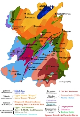
is very diverse and most rock types found in the British Isles
British Isles
The British Isles are a group of islands off the northwest coast of continental Europe that include the islands of Great Britain and Ireland and over six thousand smaller isles. There are two sovereign states located on the islands: the United Kingdom of Great Britain and Northern Ireland and...
can be found in the county too. There is also a large amount of mineral wealth, including lead
Lead
Lead is a main-group element in the carbon group with the symbol Pb and atomic number 82. Lead is a soft, malleable poor metal. It is also counted as one of the heavy metals. Metallic lead has a bluish-white color after being freshly cut, but it soon tarnishes to a dull grayish color when exposed...
, coal
Coal
Coal is a combustible black or brownish-black sedimentary rock usually occurring in rock strata in layers or veins called coal beds or coal seams. The harder forms, such as anthracite coal, can be regarded as metamorphic rock because of later exposure to elevated temperature and pressure...
and iron
Iron
Iron is a chemical element with the symbol Fe and atomic number 26. It is a metal in the first transition series. It is the most common element forming the planet Earth as a whole, forming much of Earth's outer and inner core. It is the fourth most common element in the Earth's crust...
in the county, which perhaps helped the area develop the first industry of the industrial revolution
Industrial Revolution
The Industrial Revolution was a period from the 18th to the 19th century where major changes in agriculture, manufacturing, mining, transportation, and technology had a profound effect on the social, economic and cultural conditions of the times...
, in the Ironbridge Gorge
Ironbridge Gorge
The Ironbridge Gorge is a deep gorge formed by the River Severn in Shropshire, England.Originally called the Severn Gorge, the gorge now takes its name from its famous Iron Bridge, the first iron bridge of its kind in the world, and a monument to the industry that began there...
area.
Upon looking at a geological map of the county, the most obvious feature is the Church Stretton
Church Stretton
Church Stretton is a small town and civil parish in Shropshire, England. The population of the town was recorded as 2,789 in 2001, whilst the population of the wider parish was recorded as 4,186...
fault
Geologic fault
In geology, a fault is a planar fracture or discontinuity in a volume of rock, across which there has been significant displacement along the fractures as a result of earth movement. Large faults within the Earth's crust result from the action of tectonic forces...
. This runs, initially, from South West Wales
Wales
Wales is a country that is part of the United Kingdom and the island of Great Britain, bordered by England to its east and the Atlantic Ocean and Irish Sea to its west. It has a population of three million, and a total area of 20,779 km²...
, entering the county of Shropshire in the south west, near the small town of Clun. It travels north eastwards through the county, dividing the county in two, before coming to an end near the town of Newport
Newport, Shropshire
Newport is a market town in the borough of Telford and Wrekin and ceremonial county of Shropshire, England. It lies some north of Telford and some west of Stafford sitting on the Shropshire/Staffordshire border...
. The fault itself passes through Church Stretton, the location of the Long Mynd
Long Mynd
The Long Mynd in Shropshire, England, is a part of the Shropshire Hills Area of Outstanding Natural Beauty. It is south of the county town Shrewsbury, and has an area of over 22 square kilometres , most of which takes the form of a heathland plateau. Most of the land on the Long Mynd is owned by...
, and also passes close to The Wrekin. Another, smaller fault exists in Shropshire, the Pontesbury Linley fault, situated near the village of Pontesbury
Pontesbury
Pontesbury is a large village and civil parish in Shropshire and is approximately eight miles southwest of the county town of Shrewsbury. The village of Minsterley is just over a mile further southwest. The A488 road runs through the village, on its way from Shrewsbury to Bishop's Castle...
, south west of the county town of Shrewsbury
Shrewsbury
Shrewsbury is the county town of Shropshire, in the West Midlands region of England. Lying on the River Severn, it is a civil parish home to some 70,000 inhabitants, and is the primary settlement and headquarters of Shropshire Council...
.
The oldest rocks in Shropshire are to be found near Shrewsbury, on Haughmond Hill. The sedimentary rocks here are Precambrian
Precambrian
The Precambrian is the name which describes the large span of time in Earth's history before the current Phanerozoic Eon, and is a Supereon divided into several eons of the geologic time scale...
in age, and quarried for use on roads. The hill itself provides an amazing view across large parts of mid Shropshire.
The Wrekin
The Wrekin
The Wrekin is a hill in east Shropshire, England. It is located some west of Telford, on the border between the unitary authorities of Shropshire and Telford and Wrekin. Rising to a height of above the Shropshire Plain, it is a prominent and well-known landmark, marking the entrance to Shropshire...
is a prominent hill near the town of Telford
Telford
Telford is a large new town in the borough of Telford and Wrekin and ceremonial county of Shropshire, England, approximately east of Shrewsbury, and west of Birmingham...
. The sedimentary rock types are varied around the area, but lava
Lava
Lava refers both to molten rock expelled by a volcano during an eruption and the resulting rock after solidification and cooling. This molten rock is formed in the interior of some planets, including Earth, and some of their satellites. When first erupted from a volcanic vent, lava is a liquid at...
from various volcanic eruptions
Volcanic Eruptions
Volcanic Eruptions is a company owned by Crispin Glover. The company produces and issues Glover's work: It has released two films to date, What Is It? and its sequel, It is Fine! EVERYTHING IS FINE . Its current plans include releasing the final film in the trilogy titled It Is Mine...
formed this landmark, however, The Wrekin itself is not a volcano, and never was. The primary igneous rock on the Wrekin is rhyolite which has a pinkish colour and is usually banded as it is a slow cooling viscous extrusive rock. A particularly good outcrop of rhyolite exists as you drive between Wellington and Shrewsbury on the new A5 by-pass. Intrusions of igneous rock have been quarried in the past at nearby Ercall Quarry. Here, the main type of igneous rock that can be found is Granophyre
Granophyre
Granophyre is a subvolcanic rock that contains quartz and alkali feldspar in characteristic angular intergrowths such as those in the accompanying image....
. At Ercall Quarry itself, you can see the boundary between Precambrian rocks and the Cambrian
Cambrian
The Cambrian is the first geological period of the Paleozoic Era, lasting from Mya ; it is succeeded by the Ordovician. Its subdivisions, and indeed its base, are somewhat in flux. The period was established by Adam Sedgwick, who named it after Cambria, the Latin name for Wales, where Britain's...
explosion of life.
Not far from The Wrekin is the famous Ironbridge Gorge, named after the bridge that stands over the River Severn
River Severn
The River Severn is the longest river in Great Britain, at about , but the second longest on the British Isles, behind the River Shannon. It rises at an altitude of on Plynlimon, Ceredigion near Llanidloes, Powys, in the Cambrian Mountains of mid Wales...
near Madeley. The geological events that took place here thousands of years ago were what made the events that took place here in the Industrial Revolution possible, as the Gorge itself was carved out by an ice sheet, together with its melt water, towards the end of the last ice age
Ice age
An ice age or, more precisely, glacial age, is a generic geological period of long-term reduction in the temperature of the Earth's surface and atmosphere, resulting in the presence or expansion of continental ice sheets, polar ice sheets and alpine glaciers...
, some 15,000 years ago.
Much of North Shropshire
North Shropshire
North Shropshire was a local government district in Shropshire, England. The district council was based at Edinburgh House, in Wem. Other settlements included the towns of Ellesmere, Market Drayton, Wem and Whitchurch, as well as the large villages of Shawbury and Baschurch...
is a plain which is a basin of Permian
Permian
The PermianThe term "Permian" was introduced into geology in 1841 by Sir Sir R. I. Murchison, president of the Geological Society of London, who identified typical strata in extensive Russian explorations undertaken with Edouard de Verneuil; Murchison asserted in 1841 that he named his "Permian...
and Triassic
Triassic
The Triassic is a geologic period and system that extends from about 250 to 200 Mya . As the first period of the Mesozoic Era, the Triassic follows the Permian and is followed by the Jurassic. Both the start and end of the Triassic are marked by major extinction events...
New Red Sandstone
New Red Sandstone
The New Red Sandstone is a chiefly British geological term for the beds of red sandstone and associated rocks laid down throughout the Permian to the beginning of the Triassic that underlie the Jurassic Lias; the term distinguishes it from the Old Red Sandstone which is largely Devonian in...
, overlain by Jurassic
Jurassic
The Jurassic is a geologic period and system that extends from about Mya to Mya, that is, from the end of the Triassic to the beginning of the Cretaceous. The Jurassic constitutes the middle period of the Mesozoic era, also known as the age of reptiles. The start of the period is marked by...
deposits in a small area near Wem
Wem
Wem is a small market town in Shropshire, England. It is the administrative centre for the northern area committee of Shropshire Council, which has its headquarters at Edinburgh House in the centre of Wem. Wem railway station is on the Shrewsbury to Crewe railway line...
. This basin continues north into Cheshire
Cheshire
Cheshire is a ceremonial county in North West England. Cheshire's county town is the city of Chester, although its largest town is Warrington. Other major towns include Widnes, Congleton, Crewe, Ellesmere Port, Runcorn, Macclesfield, Winsford, Northwich, and Wilmslow...
. Faulting has occurred within the sandstones, because of slippage during or after the filling of the basin. Escarpment
Escarpment
An escarpment is a steep slope or long cliff that occurs from erosion or faulting and separates two relatively level areas of differing elevations.-Description and variants:...
s form small prominent hills within the plain. The basin is bounded on the east by the Hodnet Fault, which runs roughly from Shrewsbury to Market Drayton
Market Drayton
Market Drayton is a small market town in north Shropshire, England. It is on the River Tern, between Shrewsbury and Stoke-on-Trent, and was formerly known as "Drayton in Hales" and earlier simply as "Drayton" ....
. East of this fault the sandstone is thinner. In the north west of the county near Oswestry are outcrops of Carboniferous Limestone
Carboniferous limestone
Carboniferous Limestone is a term used to describe a variety of different types of limestone occurring widely across Great Britain and Ireland which were deposited during the Dinantian epoch of the Carboniferous period. They were formed between 363 and 325 million years ago...
and the Coal Measures
Coal Measures
The Coal Measures is a lithostratigraphical term for the coal-bearing part of the Upper Carboniferous System. It represents the remains of fluvio-deltaic sediment, and consists mainly of clastic rocks interstratified with the beds of coal...
.
Igneous intrusion
Intrusion
An intrusion is liquid rock that forms under Earth's surface. Magma from under the surface is slowly pushed up from deep within the earth into any cracks or spaces it can find, sometimes pushing existing country rock out of the way, a process that can take millions of years. As the rock slowly...
s in South Shropshire, a sill
Sill (geology)
In geology, a sill is a tabular sheet intrusion that has intruded between older layers of sedimentary rock, beds of volcanic lava or tuff, or even along the direction of foliation in metamorphic rock. The term sill is synonymous with concordant intrusive sheet...
of dolerite and a basalt
Basalt
Basalt is a common extrusive volcanic rock. It is usually grey to black and fine-grained due to rapid cooling of lava at the surface of a planet. It may be porphyritic containing larger crystals in a fine matrix, or vesicular, or frothy scoria. Unweathered basalt is black or grey...
intrusion, have formed the Clee Hills
Clee Hills
The Clee Hills are a range of hills in Shropshire, England near Ludlow, consisting of Brown Clee Hill , the highest peak in Shropshire, and Titterstone Clee Hill...
– Brown Clee Hill
Brown Clee Hill
Brown Clee Hill is the highest hill in the rural English county of Shropshire, at 540 metres above sea level. It is one of the Clee Hills, and is in the Shropshire Hills Area of Outstanding Natural Beauty.-Geography:...
and Titterstone Clee Hill
Titterstone Clee Hill
Titterstone Clee Hill, sometimes referred to as Clee Hill or Titterstone Clee, is a hill in the rural English county of Shropshire, rising at the summit to 533 m above sea level....
. These are two of the three highest points in Shropshire, and serve as outcrops for Old Red Sandstone
Old Red Sandstone
The Old Red Sandstone is a British rock formation of considerable importance to early paleontology. For convenience the short version of the term, 'ORS' is often used in literature on the subject.-Sedimentology:...
, and also various coal measures and limestone
Limestone
Limestone is a sedimentary rock composed largely of the minerals calcite and aragonite, which are different crystal forms of calcium carbonate . Many limestones are composed from skeletal fragments of marine organisms such as coral or foraminifera....
. Brown Clee Hill is considered to be one of the best exposures of Old Red Sandstone that exists. South Shropshire
South Shropshire
South Shropshire was, between 1974 and 2009, a local government district in south west Shropshire, England.South Shropshire was the most rural district of one of the UK's most rural counties, the population of the district was 40,410 in 2001 spread out over 1,027 km² of forest, mountains,...
was on the border of the Old Red Sandstone continent, explaining why it appears so prominently in the Clee area.
To the north west of Clee is Church Stretton, famous perhaps because it gives its name to the fault that runs through the town and the whole county. The Church Stretton hills were formed on a continental shelf
Continental shelf
The continental shelf is the extended perimeter of each continent and associated coastal plain. Much of the shelf was exposed during glacial periods, but is now submerged under relatively shallow seas and gulfs, and was similarly submerged during other interglacial periods. The continental margin,...
, but buckled up into hills at the time of a continental collision
Continental collision
Continental collision is a phenomenon of the plate tectonics of Earth that occurs at convergent boundaries. Continental collision is a variation on the fundamental process of subduction, whereby the subduction zone is destroyed, mountains produced, and two continents sutured together...
, which formed the Variscan mountains. The most famous of these hills is probably the Long Mynd, which is Precambrian in age and forms the west side of the Stretton Valley. East of Church Stretton is Wenlock Edge
Wenlock Edge
Wenlock Edge is a limestone escarpment near Much Wenlock, Shropshire, England. It is long and runs from South West to North East between Craven Arms and Much Wenlock. It is roughly 330 metres high...
, a Silurian
Silurian
The Silurian is a geologic period and system that extends from the end of the Ordovician Period, about 443.7 ± 1.5 Mya , to the beginning of the Devonian Period, about 416.0 ± 2.8 Mya . As with other geologic periods, the rock beds that define the period's start and end are well identified, but the...
limestone escarpment. The Wenlock Edge is the equivalent of the famous North American Niagara Escarpment
Niagara Escarpment
The Niagara Escarpment is a long escarpment, or cuesta, in the United States and Canada that runs westward from New York State, through Ontario, Michigan, Wisconsin and Illinois...
, which comprises Middle Silurian
Silurian
The Silurian is a geologic period and system that extends from the end of the Ordovician Period, about 443.7 ± 1.5 Mya , to the beginning of the Devonian Period, about 416.0 ± 2.8 Mya . As with other geologic periods, the rock beds that define the period's start and end are well identified, but the...
(Clinton Group) to Upper Silurian
Silurian
The Silurian is a geologic period and system that extends from the end of the Ordovician Period, about 443.7 ± 1.5 Mya , to the beginning of the Devonian Period, about 416.0 ± 2.8 Mya . As with other geologic periods, the rock beds that define the period's start and end are well identified, but the...
strata. These two escarpments were most likely in the same locale prior to the separation of the North American and European plates at the end of the Mesozoic
Mesozoic
The Mesozoic era is an interval of geological time from about 250 million years ago to about 65 million years ago. It is often referred to as the age of reptiles because reptiles, namely dinosaurs, were the dominant terrestrial and marine vertebrates of the time...
Era, 60 million years ago. This is evident by the presence of the Mid-Atlantic Ridge. South West of Church Stretton, and at the westernmost border of England
England
England is a country that is part of the United Kingdom. It shares land borders with Scotland to the north and Wales to the west; the Irish Sea is to the north west, the Celtic Sea to the south west, with the North Sea to the east and the English Channel to the south separating it from continental...
with Wales, is the very rural area of Clun
Clun
Clun is a small town in Shropshire, England. The town is located entirely in the Shropshire Hills Area of Outstanding Natural Beauty. The 2001 census recorded 642 people living in the town...
. The rocks here are mainly Silurian in age, and whilst they are, on the whole, soft rocks that are easily eroded, the topography
Topography
Topography is the study of Earth's surface shape and features or those ofplanets, moons, and asteroids...
is very varied with an impressive landscape, and the hills were put to good use in Iron Age
Iron Age
The Iron Age is the archaeological period generally occurring after the Bronze Age, marked by the prevalent use of iron. The early period of the age is characterized by the widespread use of iron or steel. The adoption of such material coincided with other changes in society, including differing...
times with the use of fortresses on the hills around Clun and Anchor
Anchor, Shropshire
Anchor is a remote hamlet in Shropshire, England, located at . The hamlet is the most westerly place in Shropshire.-Geography:Anchor lies only 400m away from the border with Wales. The B4368 road runs through the hamlet on its way between the towns of Clun to Newtown...
.
See also
- Geology of the United Kingdom
- Geology of EnglandGeology of EnglandThe Geology of England is mainly sedimentary. The youngest rocks are in the south east around London, progressing in age in a north westerly direction. The Tees-Exe line marks the division between younger, softer and low-lying rocks in the south east and older, harder, and generally a higher relief...
- List of geology of English counties
- Geology of CheshireGeology of CheshireThe geology of Cheshire in England consists mainly of Triassic sandstones and mudstones. To the north west of Cheshire, these rocks are heavily faulted and the underlying Carboniferous Coal Measures are thrown up. Around the areas of Poynton and Macclesfield, the coal is close to the surface and...
- Wenlock EdgeWenlock EdgeWenlock Edge is a limestone escarpment near Much Wenlock, Shropshire, England. It is long and runs from South West to North East between Craven Arms and Much Wenlock. It is roughly 330 metres high...
- Long Mynd#Geology
- Longmyndian SupergroupLongmyndian SupergroupThe Longmyndian Supergroup is a c.6000m thick sequence of rocks that outcrop between the Pontesford-Linley Fault System and the Church Stretton Fault System in the Welsh Borderland. The supergroup consists of two major geological groups, the Stretton Group and the overlying Wentnor Group. The rocks...
- UriconianUriconianThe Uriconian rocks of Shropshire are thought to be potentially related to the Longmyndian Supergroup of the Stretton Hills, Shropshire, United Kingdom. Current geological profiling of the terranes suggests that the Uriconian rocks are of Precambrian age...