
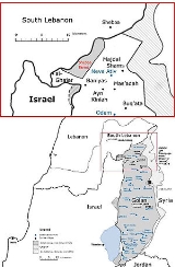
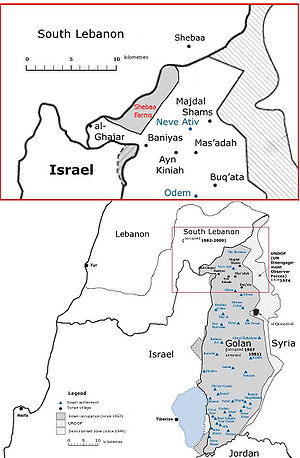
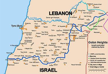
Shebaa farms
Encyclopedia
Lebanon
Lebanon , officially the Republic of LebanonRepublic of Lebanon is the most common term used by Lebanese government agencies. The term Lebanese Republic, a literal translation of the official Arabic and French names that is not used in today's world. Arabic is the most common language spoken among...
, but occupied by Israel which claims they are in Syria
Syria
Syria , officially the Syrian Arab Republic , is a country in Western Asia, bordering Lebanon and the Mediterranean Sea to the West, Turkey to the north, Iraq to the east, Jordan to the south, and Israel to the southwest....
's Golan Heights. Syrian policy is to vaguely accept the Lebanese claim, while refusing any binding demarcation until Israeli forces withdraw from the area.
The United Nations
United Nations
The United Nations is an international organization whose stated aims are facilitating cooperation in international law, international security, economic development, social progress, human rights, and achievement of world peace...
had to decide upon a "withdrawal line" for Israel to withdraw from the Lebanon (for Security Council Resolution 425
United Nations Security Council Resolution 425
United Nations Security Council Resolution 425, adopted on March 19, 1978, five days after the Israeli invasion of Lebanon, called on Israel to withdraw immediately its forces from Lebanon and established the United Nations Interim Force In Lebanon...
). The UN certified Israel's withdrawal as conforming to that line, which did not contain the Shebaa Farms. However the UN has proposed that Israel also withdraws from the Shebaa Farms and that it be considered international territory under UNIFIL.
Documents from the 1920s and 1930s indicate that some local inhabitants regarded themselves as part of Lebanon, but after the French mandate ended in 1946, the land was administered by Syria, and represented as such in all maps of the time, including 1949 Armistice Agreement maps and Syrian and Lebanese military maps. The Shebaa Farms were then occupied by Israel in the 1967 Six-Day War
Six-Day War
The Six-Day War , also known as the June War, 1967 Arab-Israeli War, or Third Arab-Israeli War, was fought between June 5 and 10, 1967, by Israel and the neighboring states of Egypt , Jordan, and Syria...
.
Geography
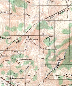
The area in question is about 9 km (5.5 mi) in length, and averages 2.5 km (1.5 mi) in width, coming to about 22 km² (8 sq mi). It is located about 3 to 12 km (2 to 7.5 mi) southwest of the Lebanese village of Shebaa, and about 5 to 7 km (3 to 4 mi) northwest of the DruzeDruze
The Druze are an esoteric, monotheistic religious community, found primarily in Syria, Lebanon, Israel, and Jordan, which emerged during the 11th century from Ismailism. The Druze have an eclectic set of beliefs that incorporate several elements from Abrahamic religions, Gnosticism, Neoplatonism...
village of Majdal Shams
Majdal Shams
Majdal Shams is a Druze village in the northern part of the Golan Heights, in the southern foothills of Mt. Hermon. Since the June 1967 Six-Day War, the village has been controlled by Israel, first under martial law, but since 1981 under Israeli civil law, and incorporated into the Israeli...
. Shebaa Farms is situated on the southeastern side of a long, broad ridge
Ridge
A ridge is a geological feature consisting of a chain of mountains or hills that form a continuous elevated crest for some distance. Ridges are usually termed hills or mountains as well, depending on size. There are several main types of ridges:...
descending to the southwest from Mount Hermon
Mount Hermon
Mount Hermon is a mountain cluster in the Anti-Lebanon mountain range. Its summit straddles the border between Syria and Lebanon and, at 2,814 m above sea level, is the highest point in Syria. On the top there is “Hermon Hotel”, in the buffer zone between Syria and Israeli-occupied...
. The northwestern edge of the area corresponds to the international Lebanese-Syrian border (still recognized by the United Nations
United Nations
The United Nations is an international organization whose stated aims are facilitating cooperation in international law, international security, economic development, social progress, human rights, and achievement of world peace...
) along that ridge. The southeastern edge lies parallel to Wadi al-Asal (Nahal Si'on), a 16 km long wadi
Wadi
Wadi is the Arabic term traditionally referring to a valley. In some cases, it may refer to a dry riverbed that contains water only during times of heavy rain or simply an intermittent stream.-Variant names:...
that flows into Israel, draining a portion of the relatively precipitation-rich Hermon ridge in the northern Golan Heights. These "edges" are connected by the Shebaa Farms' northeastern limit 2.5 km east of IDF military camp at Har Dov as defined by a 2007 UN report.
The same report defines the southwestern limit as a line roughly following the foot of the ridge and starting at just over a kilometer northwest of Banias
Banias
Banias is an archaeological site by the ancient city of Caesarea Philippi, located at the foot of Mount Hermon in the Golan Heights...
, then running northwest to the international Lebanon-Syrian border's sharp turning point 3.4 km east of Ghajar
Ghajar
Ghajar is an Alawite village on the Hasbani River on the border between Lebanon and the Israeli-occupied portion of the Golan Heights. It has a population of 2,000.-Early history:...
and 1.0 km "south of the (Lebanese) village of El Majidiye." This southwestern limit of Shebaa Farms comes within about 1 km of the 1949 Armistice Line
1949 Armistice Agreements
The 1949 Armistice Agreements are a set of agreements signed during 1949 between Israel and neighboring Egypt, Lebanon, Jordan, and Syria. The agreements ended the official hostilities of the 1948 Arab-Israeli War, and established armistice lines between Israeli forces and the forces in...
, international border between Israeli and Syria. The only overland route between Lebanon and Syria south of the Mount Hermon
Mount Hermon
Mount Hermon is a mountain cluster in the Anti-Lebanon mountain range. Its summit straddles the border between Syria and Lebanon and, at 2,814 m above sea level, is the highest point in Syria. On the top there is “Hermon Hotel”, in the buffer zone between Syria and Israeli-occupied...
ridge used to run between these two lines. The small farms in this area are not used since the Six-Day War
Six-Day War
The Six-Day War , also known as the June War, 1967 Arab-Israeli War, or Third Arab-Israeli War, was fought between June 5 and 10, 1967, by Israel and the neighboring states of Egypt , Jordan, and Syria...
. The area includes heights overlooking parts of southern Lebanon and Israel to the west. Elevations range from about 250 to about 1,500 m (825–4,940 ft).
Even after the Israeli military withdrawal from southern Lebanon in 2000, to the line designated by UN officials, Hezbollah cites what it sees as continued Israeli occupation of the disputed Shebaa Farms as justification for attacks on Israel. In a speech in August 2008, the president of Lebanon, Michel Suleiman
Michel Suleiman
Michel Suleiman or Sleiman is the President of Lebanon. Before assuming office as President, he held the position of commander of the Lebanese Armed Forces. After LAF commander Émile Lahoud took office as president in November of 1998, Suleiman succeeded him, taking his place in December...
stated: "The countdown for liberating the rest of our lands has begun. And today I confirm the [use] of all available and legitimate means to achieve this goal".
Etymology
Lebanese press and officials often refer to this area, just southeast of the Lebanese village of Kafr Shuba, as the Kafr Shuba Hills. On old maps it is labelled Jebal ar Ru'us, Jebel Rous or Jabel Rous.Israel refers to the northern, higher part of the area as Har Dov (Mount Dov), named after Dov Rodberg, an IDF
Israel Defense Forces
The Israel Defense Forces , commonly known in Israel by the Hebrew acronym Tzahal , are the military forces of the State of Israel. They consist of the ground forces, air force and navy. It is the sole military wing of the Israeli security forces, and has no civilian jurisdiction within Israel...
officer killed there in 1970.
Current dispute
When Israel captured the Golan Heights from SyriaSyria
Syria , officially the Syrian Arab Republic , is a country in Western Asia, bordering Lebanon and the Mediterranean Sea to the West, Turkey to the north, Iraq to the east, Jordan to the south, and Israel to the southwest....
in 1967 during the Six Day War, the Shebaa Farms were considered in practice to be part of the Syrian territory. Lebanon
Lebanon
Lebanon , officially the Republic of LebanonRepublic of Lebanon is the most common term used by Lebanese government agencies. The term Lebanese Republic, a literal translation of the official Arabic and French names that is not used in today's world. Arabic is the most common language spoken among...
was not an active participant in the war. In 1981 Israel extended Israeli law
Israeli law
Israeli law is a mixed legal system reflecting the diverse history of the territory of the State of Israel throughout the last hundred years , as well as the legal systems of its major religious communities...
to the region under its Golan Heights Law
Golan Heights Law
The Golan Heights Law is the Israeli law which applies Israel's government and laws to the Golan Heights. It was ratified by the Knesset on December 14, 1981. The law was condemned internationally and determined null and void by United Nations Security Council Resolution 497.The law was passed...
. The United Nations Security Council
United Nations Security Council
The United Nations Security Council is one of the principal organs of the United Nations and is charged with the maintenance of international peace and security. Its powers, outlined in the United Nations Charter, include the establishment of peacekeeping operations, the establishment of...
has declared this extension of "[Israeli] laws, jurisdiction and administration... null and void and without international legal effect" in Resolution 497
United Nations Security Council Resolution 497
United Nations Security Council Resolution 497, adopted unanimously on December 17, 1981, calls on the State of Israel to rescind its de facto annexation of the Golan Heights...
, which was not passed with Chapter VII
Chapter VII of the United Nations Charter
Chapter VII of the United Nations Charter sets out the UN Security Council's powers to maintain peace. It allows the Council to "determine the existence of any threat to the peace, breach of the peace, or act of aggression" and to take military and nonmilitary action to "restore international peace...
enforcement powers.
A controversy arose following the withdrawal of Israeli troops from occupied territory in Southern Lebanon
Southern Lebanon
Southern Lebanon is the geographical area of Lebanon comprising the South Governorate and the Nabatiye Governorate. These two entities were divided from the same province in the early 1990s...
on May 24, 2000. On June 18, 2000, the United Nations affirmed that Israel had withdrawn its forces from Lebanon, in accordance with Resolution 425
United Nations Security Council Resolution 425
United Nations Security Council Resolution 425, adopted on March 19, 1978, five days after the Israeli invasion of Lebanon, called on Israel to withdraw immediately its forces from Lebanon and established the United Nations Interim Force In Lebanon...
. Syria and Lebanon disputed the United Nations
United Nations
The United Nations is an international organization whose stated aims are facilitating cooperation in international law, international security, economic development, social progress, human rights, and achievement of world peace...
certification that Israel's withdrawal from Lebanon was complete. Hezbollah cites the ongoing occupation of the Shebaa farms as one reason for its continued attacks on Israel.
Between 2000–2005, Hezbollah attacked the IDF at Shebaa/Har Dov 33 times, resulting in seven Israeli soldiers killed in action, three taken prisoner, and dozens wounded.
For decades members of the international diplomatic community have repeatedly requested that Syria and Lebanon take steps to determine the exact boundary between them in the Shebaa Farms region and Syria, including officially registering the demarcated border with the United Nations. However, recently President Bashar al-Assad
Bashar al-Assad
Bashar al-Assad is the President of Syria and Regional Secretary of the Ba'ath Party. His father Hafez al-Assad ruled Syria for 29 years until his death in 2000. Al-Assad was elected in 2000, re-elected in 2007, unopposed each time.- Early Life :...
of Syria has refused to do so until Israeli troops withdraw. On October 31, 2007, the definition of the physical extent of the Shebaa Farms area by former UN cartographer Miklos Pinther was released by the UN. This could be a prelude to an eventual negotiated demarcation of the territory.
Background
The dispute over the sovereignty of the Shebaa Farms resulted in part from the failure of the French MandateLeague of Nations mandate
A League of Nations mandate was a legal status for certain territories transferred from the control of one country to another following World War I, or the legal instruments that contained the internationally agreed-upon terms for administering the territory on behalf of the League...
administrations, and subsequently the Lebanese and Syrian governments, to demarcate the border between Lebanon and Syria properly.
Documents from the 1920s and 1930s indicate that some local inhabitants regarded themselves as part of Lebanon, for example paying taxes to the Lebanese government. But French officials at times expressed confusion as to the actual location of the border. One French official in 1939 expressed the belief that the uncertainty was sure to cause trouble in the future.
The region continued to be represented in the 1930s and 1940s as Syrian territory, under the French Mandate. Detailed maps showing the border were produced by the French in 1933, and again in 1945. They clearly showed the region to be in Syria.
After the French Mandate ended in 1946, the land was administered by Syria, and represented as such in all maps of the time.
The maps of the 1949 Armistice Agreements between Syria and Israel also designated the area as Syrian. Border disputes arose at times, however. Shebaa Farms was not unique; several other border villages had similar discrepancies of borders versus land ownership. Syria and Lebanon formed a joint Syrian-Lebanese border committee in the late 1950s to determine a proper border between the two nations. In 1964, concluding its work, the committee suggested to the two governments that the area be deemed the property of Lebanon, and recommended that the international border be reestablished consistent with its suggestion. However, neither Syria nor Lebanon adopted the committee's suggestion, and neither country took any action along the suggested lines. Thus, maps of the area continued to reflect the Farms as being in Syria. Even maps of both the Syrian and Lebanese armies continued to demarcate the region within Syrian territory.
In 1967 most Shebaa Farms landowners and (Lebanese) farmers lived outside the Syrian-controlled region, across the Lebanon-Syrian border, in the Lebanese village of Shebaa. During the Six Day War, Israel captured the area from Syria. As a consequence, the Lebanese landowners were no longer able to farm it.
UN Security Council Resolution 242
In 1967, following the Six Day War, the United Nations Security CouncilUnited Nations Security Council
The United Nations Security Council is one of the principal organs of the United Nations and is charged with the maintenance of international peace and security. Its powers, outlined in the United Nations Charter, include the establishment of peacekeeping operations, the establishment of...
passed Resolution 242 (1967)
United Nations Security Council Resolution 242
United Nations Security Council Resolution 242 was adopted unanimously by the UN Security Council on November 22, 1967, in the aftermath of the Six Day War. It was adopted under Chapter VIof the United Nations Charter...
, later reaffirmed by UN Security Council Resolution 338 (1973), calling for all four of the following:
- The "withdrawal of Israel armed forces from territories occupied in the recent conflict." There is a major dispute whether the language requires withdrawal from "all" occupied territories, the French text being "des territoires occupés," meaning "from the occupied territories." (For a discussion of the dispute, see the article on Resolution 242United Nations Security Council Resolution 242United Nations Security Council Resolution 242 was adopted unanimously by the UN Security Council on November 22, 1967, in the aftermath of the Six Day War. It was adopted under Chapter VIof the United Nations Charter...
.) The territory is subject to this clause of Resolution 242, irrespective of whether it is considered part of Syria or Lebanon. - The recognition by Israel, EgyptEgyptEgypt , officially the Arab Republic of Egypt, Arabic: , is a country mainly in North Africa, with the Sinai Peninsula forming a land bridge in Southwest Asia. Egypt is thus a transcontinental country, and a major power in Africa, the Mediterranean Basin, the Middle East and the Muslim world...
, Syria, and JordanJordanJordan , officially the Hashemite Kingdom of Jordan , Al-Mamlaka al-Urduniyya al-Hashemiyya) is a kingdom on the East Bank of the River Jordan. The country borders Saudi Arabia to the east and south-east, Iraq to the north-east, Syria to the north and the West Bank and Israel to the west, sharing...
of each other. - The termination of all claims or states of belligerency.
- The establishment of secure mutually recognized boundaries for all parties.
In 1981, the area was unofficially annexed by Israel, as part of the Golan Heights which ordered the implementation of Israeli civil law on the Golan Heights in lieu of the military administration. This unilateral annexation is not recognised by the UN.
Operation Litani
In 1978 Israel invaded southern Lebanon in Operation LitaniOperation Litani
The 1978 South Lebanon conflict was an invasion in Lebanon up to the Litani River carried out by the Israel Defense Forces in 1978. It was a military success for the Israeli Defense Forces, as PLO forces were pushed north of the river...
. The UN Security Council passed Resolution 425, calling on Israel:
- "to withdraw forthwith its forces from all Lebanese territory." The phrase "all territory" was used in Resolution 425, in contrast to the language in Resolution 242 (1967), which led to semantic disputes.
On May 22, 2000, Israel completed its withdrawal from southern Lebanon in accordance with Resolution 425. The UN certified the completion of Israel's pullout.
Lebanese claims
In 2000, Lebanon disputed Israel's compliance with Resolution 425. Lebanon claimed that the Shebaa Farms area was actually Lebanese, and demanded that the Israelis should therefore withdraw from there as well. Lebanon asserted that the UN certification of the Israeli withdrawal was "invalid," because of Lebanon's claim to the Farms.Lebanese officials point to land deed
Deed
A deed is any legal instrument in writing which passes, or affirms or confirms something which passes, an interest, right, or property and that is signed, attested, delivered, and in some jurisdictions sealed...
s, stamped by the Lebanese government, that were held by a number of area residents in the 1940s and 1950s. The Lebanese claim to this area is asserted by Hezbollah for its continuing conflict with Israel, and its cross-border attacks after the Israeli withdrawal. Senior Lebanese officials also linked the withdrawal of Israeli forces from Shebaa to Hezbollah’s disarmament. "If the U.S. and friendly countries help us achieve the withdrawal of Israel from Shebaa farms, this would make it possible for the Lebanese forces to be the sole owner of weapons and arms in the country," Lebanese Prime Minister Foaud Seniora said. Those comments were echoed by Lebanese President Émile Lahoud who said that "the resistance should be kept until a just and comprehensive peace is achieved in the region", adding that "if the Lebanese army were deployed along the borders (with Israel) ... it would be turned into a police force to protect Israel's borders, and this is not acceptable."
Walid Jumblatt
Walid Jumblatt
Walid Jumblatt is a Lebanese politician and the current leader of the Progressive Socialist Party . He is the most prominent leader of Lebanon's Druze community.-Family:...
, a Lebanese Druze
Druze
The Druze are an esoteric, monotheistic religious community, found primarily in Syria, Lebanon, Israel, and Jordan, which emerged during the 11th century from Ismailism. The Druze have an eclectic set of beliefs that incorporate several elements from Abrahamic religions, Gnosticism, Neoplatonism...
politician and leader of the Progressive Socialist Party
Progressive Socialist Party
The Progressive Socialist Party or PSP , also known as Parti Socialiste Progressiste in French, is a political party in Lebanon. Its current leader is Walid Jumblatt...
, stated that Lebanon has no claims to the Shebaa farms. However, both the prime minister and president stated that Lebanon does have a claim to the area. On August 28, 2006, Hezbollah fighters withdrew from positions facing Israeli occupation lines in the Shebaa Farms area.
Maps published on the Lebanese army website show different versions of the Lebanese southern border. While the Shebaa Farms themselves are not marked on the maps, it is evident from one map that the border runs north of the Shebaa Farms, while another map marks the border south of the Farms.
A Lebanese newspaper, however, described the land deed of one Shebaa resident as "handwritten and signed on a yellowing piece of paper in pencil and ink." Moreover, it is quite common for Lebanese to own land in Syria, and vice versa and it is also common for many people of a country to not know the name of one region.
According to the Arab newspaper, Al-Hayat, most Lebanese had never heard or read about the Farms, even in their national school curricula. "The issue over these farms was created to justify resistance operations from Lebanon after the UN had created the Blue Line
Blue Line (Lebanon)
The Blue Line is a border demarcation between Lebanon and Israel published by the United Nations on 7 June 2000 for the purposes of determining whether Israel had fully withdrawn from Lebanon...
following Israel's withdrawal from Lebanon. The Shebaa farms were placed inside Syrian territory. It should be noted that Syria, which claims that the farms are Lebanese, has not presented a single document to the UN to prove it. Moreover, Syria refuses to demarcate its borders with Lebanon."
Syrian claims
Syria has at times supported Lebanon's claim that the Shebaa Farms are part of Lebanon and not Syrian territory, at the UN and in official government press releases. But at other times it has made contrary statements. In August 1972, Syrian president Hafez al-AssadHafez al-Assad
Hafez ibn 'Ali ibn Sulayman al-Assad or more commonly Hafez al-Assad was the President of Syria for three decades. Assad's rule consolidated the power of the central government after decades of coups and counter-coups, such as Operation Wappen in 1957 conducted by the Eisenhower administration and...
said, "Syria and Lebanon are a single country." The Shebaa Farms also appear as part of Syria on the large-scale map on the Syrian Ministry of Tourism's website. On May 16, 2000, the Syrian Foreign Minister, Farouq al-Shara, indicated to UN Secretary-General Kofi Annan
Kofi Annan
Kofi Atta Annan is a Ghanaian diplomat who served as the seventh Secretary-General of the UN from 1 January 1997 to 31 December 2006...
in a telephone conversation that Syria supported Lebanon's claim. This was made public in the UN Press Release SC/6878 of June 18, 2000 which stated "Concerning the Shab'a farmlands, both Lebanon and Syria state that this land belongs to Lebanon."
However, on January 21, 2006, the President of Syria Bashar al-Assad
Bashar al-Assad
Bashar al-Assad is the President of Syria and Regional Secretary of the Ba'ath Party. His father Hafez al-Assad ruled Syria for 29 years until his death in 2000. Al-Assad was elected in 2000, re-elected in 2007, unopposed each time.- Early Life :...
stated in a speech before the convention of the Arab Lawyers Union in Damascus
Damascus
Damascus , commonly known in Syria as Al Sham , and as the City of Jasmine , is the capital and the second largest city of Syria after Aleppo, both are part of the country's 14 governorates. In addition to being one of the oldest continuously inhabited cities in the world, Damascus is a major...
and translated into English by SANA, the official state news agency of Syria that there are two legal requirements for demarcating the border: first, the complaint must be registered with the UN; and second, engineers must precisely define the border. As neither Syria nor Lebanon have access to the area, Assad argues that resolution is waiting on Israeli withdrawal from the occupied territory.
In an interview with Assad reported by SANA on August 24, 2006, Assad flatly refused demarcation of the Syrian/Lebanese border near Shebaa Farms before a withdrawal of Israeli troops.
Former Vice President of Syria Abdel-Halim Khaddam, in an interview with the Lebanese Future Television
Future Television
Future Television a television station broadcasting from Lebanon. It was founded in 1993 by Rafik Hariri, a former Prime Minister of Lebanon. Future TV is also available via satellite in Europe, the United States, Canada, and Australia. Politically, the channel supports the views of the Future...
on August 27, 2006, said: "Saying that the farms are occupied, and hence cannot be demarcated, is nothing but a pretext. The demarcation would not take more than an hour if there was a political will."
Israeli claims
Israel claims that the area is not covered by UN Security Council Resolution 425, which governed Israel's withdrawal from Lebanon, stating that the Farms were not Lebanese territory. In support of that view, Israel points to the fact that the UN certified Israel's pullout from Lebanon as having been completed.Israel says the land was Syrian when it was captured during the Six Day War, and the dispute is being used by Hezbollah to continue its attacks on Israel.
On June 21, 2008, DEBKAFile claimed that in a June 15, 2008, meeting in Jerusalem, Israeli Prime Minister Ehud Olmert
Ehud Olmert
Ehud Olmert is an Israeli politician and lawyer. He served as Prime Minister of Israel from 2006 to 2009, as a Cabinet Minister from 1988 to 1992 and from 2003 to 2006, and as Mayor of Jerusalem from 1993 to 2003....
told US Secretary of State Condoleezza Rice
Condoleezza Rice
Condoleezza Rice is an American political scientist and diplomat. She served as the 66th United States Secretary of State, and was the second person to hold that office in the administration of President George W. Bush...
that he was "willing to evacuate Israeli troops and hand [the Shebaa farms] to United Nations custody as early as July."
US position
John BoltonJohn R. Bolton
John Robert Bolton is an American lawyer and diplomat who has served in several Republican presidential administrations. He served as the U.S. Permanent Representative to the United Nations from August 2005 until December 2006 on a recess appointment...
, former United States Ambassador to the United Nations, said on April 26, 2006: "I think the overwhelming preponderance of the evidence is that Shebaa Farms is Syrian territory."
In July 2006, Nancy Soderberg
Nancy Soderberg
Nancy Soderberg is an American foreign policy strategist who held several senior level positions in the Clinton administration. She currently is President of the Connect US Fund in Washington DC and resides in Jacksonville, Florida where she is a Distinguished Visiting Scholar at the University...
, former United States Ambassador to the United Nations, wrote:
- "When it was clear the Israelis were going to withdraw fully from Lebanon, Syrian and Lebanese officials fabricated the fiction that this small, sparsely populated area was part of Lebanon. They even produced a crudely fabricated map to back up the dubious claim. I and United Nations officials went into the map room in the United Nations and looked at all the maps of the region in the files for decades. All showed the Shebaa Farms clearly in Syria."
Former US president Jimmy Carter
Jimmy Carter
James Earl "Jimmy" Carter, Jr. is an American politician who served as the 39th President of the United States and was the recipient of the 2002 Nobel Peace Prize, the only U.S. President to have received the Prize after leaving office...
suggested in the Washington Post on August 1, 2006, that: "Israel should withdraw from all Lebanese territory, including Shebaa Farms."
In June, 2008, US Secretary of State Condoleezza Rice
Condoleezza Rice
Condoleezza Rice is an American political scientist and diplomat. She served as the 66th United States Secretary of State, and was the second person to hold that office in the administration of President George W. Bush...
visited Beirut
Beirut
Beirut is the capital and largest city of Lebanon, with a population ranging from 1 million to more than 2 million . Located on a peninsula at the midpoint of Lebanon's Mediterranean coastline, it serves as the country's largest and main seaport, and also forms the Beirut Metropolitan...
, stating that "the United States believes that the time has come to deal with the Shebaa Farms issue ... in accordance with [U.N. Security Council Resolution] 1701
United Nations Security Council Resolution 1701
United Nations Security Council Resolution 1701 is a resolution that was intended to resolve the 2006 Israel-Lebanon conflict.It was unanimously approved by the United Nations Security Council on 11 August 2006. The Lebanese cabinet, which includes two members of Hezbollah, unanimously approved the...
."
UN position
United Nations
The United Nations is an international organization whose stated aims are facilitating cooperation in international law, international security, economic development, social progress, human rights, and achievement of world peace...
certified Israel's pullout under Resolution 425 as conforming to the "withdrawal line" it had laid down in accordance with the maps at its disposal "for the practical purpose of confirming the Israeli withdrawal". At the same time the UN noted that its decision was "without prejudice to future border agreements between the Member States concerned," referring to Israel, Syria, and Lebanon. The UN stated:
- "On May 15, 2000, the United Nations received a map, dated 1966, from the Government of Lebanon which reflected the Government's position that these farmlands were located in Lebanon. However, the United Nations is in possession of 10 other maps issued after 1966 by various Lebanese government institutions, including the Ministry of Defense and the army, all of which place the farmlands inside the Syrian Arab Republic. The United Nations has also examined six maps issued by the Government of the Syrian Arab Republic, including three maps since 1966, which place the farmlands inside the Syrian Arab Republic."
In a June 18, 2000 statement, the Security Council noted that Israel and Lebanon had confirmed to the Secretary General, that identification of the withdrawal line was solely the responsibility of the UN and that both sides would respect the line as identified. On a fact-finding visit to the region, Terje Rød-Larsen
Terje Rød-Larsen
Terje Rød-Larsen is a Norwegian diplomat, politician and sociologist.He came to wide international prominence as a key figure in the negotiations that led to the Oslo Accords, when he served as the Director of the Fafo institute...
, the UN special envoy to the Middle East, noted that the 1923 Anglo-French demarcation and the 1949 Armistice line clearly designated the area as Syrian territory.
In April 2002, UN Secretary-General Kofi Annan, said:
- "With reference to the disturbances along the Blue LineBlue Line (Lebanon)The Blue Line is a border demarcation between Lebanon and Israel published by the United Nations on 7 June 2000 for the purposes of determining whether Israel had fully withdrawn from Lebanon...
emanating from Lebanese territory, I call on the Government of Lebanon and all relevant parties to condemn and prevent such violations. The Security Council itself confirmed in June 2000 that Israel had withdrawn from southern Lebanon in compliance with UN Security Council resolutions 425 and 426. Attacks at any point along the Blue Line, including in the Shebaa Farms area in the occupied Golan Heights, are violations of Security Council resolutions. Respect for decisions of the Security Council is the most basic requirement of international legitimacy."
On January 20, 2005 UN Secretary-General's report on Lebanon stated:
- "The continually asserted position of the Government of Lebanon that the Blue Line is not valid in the Shab'a farms area is not compatible with Security Council resolutions. The Council has recognized the Blue Line as valid for purposes of confirming Israel’s withdrawal pursuant to resolution 425 (1978). The Government of Lebanon should heed the Council’s repeated calls for the parties to respect the Blue Line in its entirety."
The BBC
BBC
The British Broadcasting Corporation is a British public service broadcaster. Its headquarters is at Broadcasting House in the City of Westminster, London. It is the largest broadcaster in the world, with about 23,000 staff...
quoted Timur Goskel, a spokesman for the United Nations Interim Force in Lebanon
United Nations Interim Force in Lebanon
The United Nations Interim Force in Lebanon, or UNIFIL, was created by the United Nations, with the adoption of Security Council Resolution 425 and 426 on 19 March 1978, to confirm Israeli withdrawal from Lebanon which Israel had invaded five days prior, restore international peace and security,...
(UNIFIL) as saying that "no-one disputed that the village of Shebaa itself was in Lebanon, but most of the farms fell into an undefined area that may be either in Lebanon or Syria" and although the UN was not a "boundary marking authority [...] on all maps the UN has been able to find, the farms are seen on the Syrian side [of the border]."
Arab league
The Arab LeagueArab League
The Arab League , officially called the League of Arab States , is a regional organisation of Arab states in North and Northeast Africa, and Southwest Asia . It was formed in Cairo on 22 March 1945 with six members: Egypt, Iraq, Transjordan , Lebanon, Saudi Arabia, and Syria. Yemen joined as a...
backed Lebanon's claim with a communique issued at Arab League's 13th session in 2001, asking for "complete Israeli withdrawal from all occupied Palestinian territory, including Jerusalem, from the occupied Syrian Golan Heights to the line of June 4, 1967 and from the remaining occupied Lebanese territory up to the internationally recognized borders, including the Shab`a farmlands".
Research findings
In 2002, Asher Kaufman of the Harry S. Truman Research Institute at the Hebrew University of JerusalemHebrew University of Jerusalem
The Hebrew University of Jerusalem ; ; abbreviated HUJI) is Israel's second-oldest university, after the Technion – Israel Institute of Technology. The Hebrew University has three campuses in Jerusalem and one in Rehovot. The world's largest Jewish studies library is located on its Edmond J...
, discovered previously unknown documents in French government archives. In one, French litigants in a private dispute entered into a private commercial agreement that suggested that the border should put the Farms in Lebanon. Two other documents, from 1937 and 1939, were reports from the administrative councilor of south Lebanon and the head of the Services Speciaux in the Syrian town of Quneitra
Quneitra
Quneitra is the largely destroyed and abandoned capital of the Quneitra Governorate in south-western Syria. It is situated in a high valley in the Golan Heights at an elevation of 1,010 metres above sea level...
. They noted a discrepancy between the border, as determined by the 1:200,000 Ottoman
Ottoman Empire
The Ottoman EmpireIt was usually referred to as the "Ottoman Empire", the "Turkish Empire", the "Ottoman Caliphate" or more commonly "Turkey" by its contemporaries...
map, and their view of the "reality" in the region. Collecting "unofficial information" from "various sources," they concluded that in their view the area was Lebanese. Their conclusion was based on the facts that: a) some area residents paid taxes to Lebanon; and b) three or four sheep pens in the Farms belonged to residents of the Lebanese village of Shaba. After Kaufman published his findings, an editorial in the Daily Star
Daily Star (Lebanon)
The Daily Star is a pan-Middle East English language newspaper edited in Beirut. It was founded in 1952 by Kamel Mrowa, the publisher of the Arabic daily Al-Hayat to serve the growing number of expatriates brought by the oil industry...
of Lebanon chided the Lebanese academic community, indicating that it was embarrassing that the discovery had been left to an Israeli researcher.
In a book published in 1988, Moshe Braver, an Israeli geographer, mentions two French maps published in 1932 and 1946, the former shows the farm area as being part of Lebanon while the latter shows the area as a Syrian territory.
Misc
- Sobelman, Daniel. New Rules of the Game: Israel and Hizbollah after the Withdrawal from Lebanon, Jaffee Center for Strategic Studies, Tel-Aviv University, 2004.