
.gif)
Route 25 (Massachusetts)
Encyclopedia
Route 25 is a numbered state highway
located in Plymouth County
and Barnstable County
, Massachusetts
, United States
. The route is a nominally east–west freeway for its entire length, and less commonly known as the Blue Star Memorial Highway. An eastward continuation of Interstate 495
, Route 25 provides freeway access to Cape Cod
. The route's western terminus is at a trumpet interchange with I-495 and I-195
in Wareham
. The route has three numbered interchanges along its 10 miles (16.1 km) length before terminating at the northern end of the Bourne Bridge in Bourne
; the mainline of Route 25 continues across the bridge and over the Cape Cod Canal
as Massachusetts Route 28 south.
Prior to 1982, the Route 25 designation was also given to a segment of what is now I-495 from Route 24 in Raynham
to the interchange with I-195 in Wareham. The freeway was redesignated as I-495 in various stages during the 1970s and 1980s, eventually reducing Route 25 to a 2.5 miles (4 km) segment that continued eastward from I-495 to the modern location of Exit 2 in Downtown Wareham. Construction of an eastern continuation of Route 25 to the Bourne Bridge was delayed for nearly three decades due to property disputes and environmental concerns, but the final 7.5 miles (12 km) segment opened in 1987. The freeway was originally planned to continue over the Bourne Bridge into Cape Cod as part of the Southside Connector
, but this plan was abandoned by the Massachusetts Highway Department
(MassHighway) in the late 1970s.
 Route 25 begins at a trumpet interchange with I-495
and I-195
in Wareham, Massachusetts
; the two left lanes of Route 25 west mainline onto Route 495 north, with the right-hand lane serving I-195 via Exit 1. From I-195, Route 25 east is accessible via Exit 22A; I-195 terminates at the interchange. Interstate 495 also terminates at its junction with Route 25; the two southbound lanes of I-495 default onto Route 25 east. After the interchange with I-195 and I-495, Route 25 begins to head in a southeastern direction into the town of Wareham as a six-lane freeway. The route passes under Tihonet Road and through Maple Swamp, located at the northern end of Parker Mills Pond
.
After the Tihonet Road overpass, the route continues on a southeastern projection, passing close to several farms and cranberry
bogs in Wareham. After passing under Charge Pond Road, Route 25 enters a densely populated region of Wareham with an alignment parallel to Route 28 (Cranberry Highway). Eastbound Route 25 has its first interchange with Maple Springs Road, a local road that connects to US 6
and Route 28 and is used to access Wareham and the village of Onset
. Shortly after the interchange, numbered as Exit 2 (formerly Exit 1), Route 25 proceeds across Agawam Mill Pond
via a short causeway
. Exit 2 off Route 25 west is located to the east of Agawam Mill Pond and connects to US 6 and Route 28 via Glen Charlie Road, an unnumbered route that also serves the village of White Island Shores
.
 After Exit 2, Route 25 bends to the northeast, bypassing Buttermilk Bay and the densely populated village of Buzzards Bay
to the south. The route passes Union Pond
and Dicks Pond to the south and Spectacle Pond
and Sandy Pond
to the north before entering the town of Plymouth. In Plymouth, Route 25 passes to the north of several cranberry bogs and small ponds. While the freeway has no interchanges in Plymouth, a rest area
is located off eastbound Route 25 in the town; the area is inaccessible from westbound Route 25. Due to state funding cutbacks, services at the rest area are limited to summer weekends (Friday to Sunday) as of 2010. After the rest area, Route 25 passes over Bourne Road and turns sharply to head in a southwestern direction. The route passes under Bournedale Road after entering the town of Bourne
. In Bourne, Route 25 has its final interchange; Exit 3 (formerly Exit 2) serves the villages of Buzzards Bay and Sagamore, connecting to US 6 (Scenic Highway) and Route 28 north. From Exit 3, US 6 is used to access the Sagamore Bridge
in northern Bourne and the towns of Hyannis
and Provincetown
on Cape Cod
.
After Exit 3, the Route 25 designation continues for 0.6 mile (0.965604 km). The six-lane freeway narrows into a four-lane undivided highway shortly before the approach ramps to the Bourne Bridge. Route 25 is concurrent with Route 28 from Exit 3 until the US 6 underpass, at which point the Route 25 designation officially ends; the two eastbound lanes of Route 25 continue as Route 28 south over the Bourne Bridge and the Cape Cod Canal
and onto Cape Cod. Route 28 continues southward to the town of Falmouth
and then eastward to Hyannis and Orleans
. An estimated daily average
of over 35,000 motorists utilized the Route 25 expressway in 2008.
 The origins of Route 25 date back to 1947, when the Massachusetts Department of Public Works (MassDPW) announced plans for an expressway that would link I-95
in Foxborough
with Cape Cod
. The planned route was given the Route 25 designation northwest of a planned interchange with the Fall River Expressway (Route 24) in Raynham
and the Route 28 designation to the southeast of Route 24. After ten years of planning studies, the route received preliminary approval from the MassDPW in 1957, and construction began in 1958; the entire route was designated as Route 25 in 1962, with Route 28 instead being aligned on local roads. The portion of the freeway between Route 24 in Raynham and I-195 in Wareham was completed in 1967. In 1969, MassDPW extended the freeway eastward to US 6
in Wareham.
In the 1970s, the MassDPW changed the planned designation of the unconstructed Route 25 expressway northwest of Route 24 to I-495. When this portion of I-495 was completed in 1982, the state also designated the existing alignment of Route 25 between Route 24 and the I-195 interchange in Wareham as I-495. After the reassignment, Route 25 was shortened to a 2.5 miles (4 km) stretch from I-195 east to Downtown Wareham.
From 1969 until 1987, the eastern terminus of Route 25 was at a junction with Maple Springs Road, US 6 and Route 28 in Wareham near the modern location of Exit 2. The MassDPW and the Massachusetts Highway Department
(MassHighway) had plans to extend the freeway eastward to Cape Cod as early as 1953, when the route was included in the proposed Cape Cod Expressway that would connect New York City
with Cape Cod. Route 25 was originally planned to connect to the Sagamore Bridge
, which carried US 6 over the Cape Cod Canal
and was used to access the towns of Hyannis
and Provincetown
. In 1962, however, the MassDPW conducted traffic studies on the two bridges crossing the canal and found that the Sagamore Bridge was above vehicular capacity, whereas the more southern Bourne Bridge had excess capacity. The Route 25 freeway was then redesigned to cross over the Bourne Bridge and connect with the Mid-Cape Highway (US 6) on the southern side of the canal via the proposed "Southside Connector". The connector would have been constructed through the Otis Air National Guard Base
in Bourne, but was canceled by the MassDPW and MassHighway in 1977 when environmental tests indicated the freeway would disturb underground aquifer
s serving as water sources for the region. MassDPW instead changed the proposed eastern terminus of the Route 25 expressway to the approach ramps of the Bourne Bridge.
 Construction of Route 25 east of Wareham, however, was delayed for nearly three decades to property disputes, environmental concerns and resistance from business owners in Buzzards Bay village, who claimed the freeway would divert all the traffic, and their business, elsewhere, leaving a ghost town
in its wake. The proposed alignment ran through land where much of the state's cranberry
harvest was located, and this led to lengthy lawsuits and delays. In particular, farmers were concerned that salt runoff
from winter ice removal would harm cranberry harvests. Throughout the 1970s and 1980s, the MassDPW developed several proposals to control storm water runoff and avoid potential damage to the cranberry crops. Engineers for the department developed four different drainage systems to be used along the length of the freeway that would divert runoff away from the Wareham River basin. In addition, the freeway was planned with a thicker asphalt pavement that was largely impervious to water.
The freeway was also delayed due to a larger property dispute with Hope Ingersoll, the owner of the 900 acres (364 ha) Grazing Fields Farm on Bournedale Road in Bourne, well-known in the region as an artists' colony
and a producer of organic food
. MassDPW proposed constructing Route 25 through the center of the farm, but Ingersoll hired engineers to develop an alternate routing. In 1978, MassDPW rejected Ingersoll's design, instead approving the alignment that ran through farmland seized by eminent domain
. In 1980, a state judge ruled that MassDPW had to conduct environmental studies on both the original routing and Ingersoll's proposal. MassDPW eventually opted to construct Ingersoll's design, giving Route 25 a longer alignment that arced to the north and east of Grazing Fields Farm before turning westward toward the Buzzards Bay business district and the Bourne Bridge. The route finally began construction in 1982, and in 1989 the MassDPW was forced to pay Ingersoll $2.6 million (1982 USD
) for 90 acres (36 ha) of farmland seized for the expressway's construction.
In 1987, the final 7.5 miles (12 km) segment of Route 25 from Maple Springs Road in Wareham to the Bourne Bridge was completed. A rest area and information center in Plymouth also opened with the freeway. The new expressway relieved congestion along US 6 and Route 28 in the Buzzards Bay business district, greatly reducing the number of accidents along the approach to the Bourne Bridge. In 2007, MassHighway completed a renumbering of the three interchanges along the length of Route 25 as part of a signing upgrade project; the previously unnumbered I-195 interchange was given the new Exit 1 designation.
State highway
State highway, state road or state route can refer to one of three related concepts, two of them related to a state or provincial government in a country that is divided into states or provinces :#A...
located in Plymouth County
Plymouth County, Massachusetts
Plymouth County is a county located in the U.S. state of Massachusetts. As of 2010, the population was 494,919. Its county seats are Plymouth and Brockton...
and Barnstable County
Barnstable County, Massachusetts
Barnstable County is a county located in the U.S. state of Massachusetts, consisting of Cape Cod and associated islands. As of the 2010 census, the population was 216,902...
, Massachusetts
Massachusetts
The Commonwealth of Massachusetts is a state in the New England region of the northeastern United States of America. It is bordered by Rhode Island and Connecticut to the south, New York to the west, and Vermont and New Hampshire to the north; at its east lies the Atlantic Ocean. As of the 2010...
, United States
United States
The United States of America is a federal constitutional republic comprising fifty states and a federal district...
. The route is a nominally east–west freeway for its entire length, and less commonly known as the Blue Star Memorial Highway. An eastward continuation of Interstate 495
Interstate 495 (Massachusetts)
Interstate 495 is the designation of an Interstate Highway half-beltway in Massachusetts. It was the longest auxiliary Interstate Highway of its kind—measuring 120.74 miles —until 1996, when the PA Route 9 section of the Pennsylvania Turnpike was redesignated as Interstate 476, making it about ...
, Route 25 provides freeway access to Cape Cod
Cape Cod
Cape Cod, often referred to locally as simply the Cape, is a cape in the easternmost portion of the state of Massachusetts, in the Northeastern United States...
. The route's western terminus is at a trumpet interchange with I-495 and I-195
Interstate 195 (Rhode Island-Massachusetts)
Interstate 195 is an Interstate Highway running a combined 40.1 miles in the U.S. states of Massachusetts and Rhode Island. It travels from a junction with Interstate 95 in Providence, Rhode Island east to a junction with Interstate 495 and Route 25 in Wareham, Massachusetts...
in Wareham
Wareham, Massachusetts
Wareham is a town located in Plymouth County, Massachusetts. As of the 2000 census, the town had a total population of 20,335, with an estimated 2008 population of 21,221....
. The route has three numbered interchanges along its 10 miles (16.1 km) length before terminating at the northern end of the Bourne Bridge in Bourne
Bourne, Massachusetts
Bourne is a town in Barnstable County, Massachusetts, United States. The population was 18,721 at the 2000 census.For geographic and demographic information on specific parts of the town of Bourne, please see the articles on Bourne , Buzzards Bay, Monument Beach, Pocasset, Sagamore, and Sagamore...
; the mainline of Route 25 continues across the bridge and over the Cape Cod Canal
Cape Cod Canal
The Cape Cod Canal is an artificial waterway traversing the narrow neck of land that joins Cape Cod to mainland Massachusetts.Part of the Atlantic Intracoastal Waterway, the canal is roughly 17.4 miles long and connects Cape Cod Bay in the north to Buzzards Bay in the south...
as Massachusetts Route 28 south.
Prior to 1982, the Route 25 designation was also given to a segment of what is now I-495 from Route 24 in Raynham
Raynham, Massachusetts
Raynham is a town in Bristol County, Massachusetts, United States. The population was 11,739 at the 2000 census. It has one village, Raynham Center.-History:...
to the interchange with I-195 in Wareham. The freeway was redesignated as I-495 in various stages during the 1970s and 1980s, eventually reducing Route 25 to a 2.5 miles (4 km) segment that continued eastward from I-495 to the modern location of Exit 2 in Downtown Wareham. Construction of an eastern continuation of Route 25 to the Bourne Bridge was delayed for nearly three decades due to property disputes and environmental concerns, but the final 7.5 miles (12 km) segment opened in 1987. The freeway was originally planned to continue over the Bourne Bridge into Cape Cod as part of the Southside Connector
Southside Connector
The Southside Connector is a proposed expressway that would connect the Bourne Bridge to the Mid-Cape Highway near exit 2 on Cape Cod. Originally, the expressway was planned to be routed north of the canal. Plans were changed when it was discovered that the Sagamore Bridge was overcrowded and the...
, but this plan was abandoned by the Massachusetts Highway Department
Massachusetts Highway Department
The Massachusetts Highway Department was the former name of the highway department in the United States Commonwealth of Massachusetts from 1991 until it became the highway division of the Massachusetts Department of Transportation on November 1, 2009...
(MassHighway) in the late 1970s.
Route description
Interstate 495 (Massachusetts)
Interstate 495 is the designation of an Interstate Highway half-beltway in Massachusetts. It was the longest auxiliary Interstate Highway of its kind—measuring 120.74 miles —until 1996, when the PA Route 9 section of the Pennsylvania Turnpike was redesignated as Interstate 476, making it about ...
and I-195
Interstate 195 (Rhode Island-Massachusetts)
Interstate 195 is an Interstate Highway running a combined 40.1 miles in the U.S. states of Massachusetts and Rhode Island. It travels from a junction with Interstate 95 in Providence, Rhode Island east to a junction with Interstate 495 and Route 25 in Wareham, Massachusetts...
in Wareham, Massachusetts
Wareham, Massachusetts
Wareham is a town located in Plymouth County, Massachusetts. As of the 2000 census, the town had a total population of 20,335, with an estimated 2008 population of 21,221....
; the two left lanes of Route 25 west mainline onto Route 495 north, with the right-hand lane serving I-195 via Exit 1. From I-195, Route 25 east is accessible via Exit 22A; I-195 terminates at the interchange. Interstate 495 also terminates at its junction with Route 25; the two southbound lanes of I-495 default onto Route 25 east. After the interchange with I-195 and I-495, Route 25 begins to head in a southeastern direction into the town of Wareham as a six-lane freeway. The route passes under Tihonet Road and through Maple Swamp, located at the northern end of Parker Mills Pond
Parker Mills Pond
Parker Mills Pond is a pond in Wareham, Massachusetts. The Wankinco River flows through the pond. Additionally, Harlow Brook flows into the pond. The water quality is impaired due to non-native aquatic plants and non-native fish...
.
After the Tihonet Road overpass, the route continues on a southeastern projection, passing close to several farms and cranberry
Cranberry
Cranberries are a group of evergreen dwarf shrubs or trailing vines in the subgenus Oxycoccus of the genus Vaccinium. In some methods of classification, Oxycoccus is regarded as a genus in its own right...
bogs in Wareham. After passing under Charge Pond Road, Route 25 enters a densely populated region of Wareham with an alignment parallel to Route 28 (Cranberry Highway). Eastbound Route 25 has its first interchange with Maple Springs Road, a local road that connects to US 6
U.S. Route 6 in Massachusetts
Route 6 is the portion of the cross-country U.S. Route 6 in the state of Massachusetts. Route 6 runs in the state connecting Providence, Rhode Island to Fall River, New Bedford, and Cape Cod. In the Fall River and New Bedford areas, Route 6 is a secondary highway paralleling Interstate 195...
and Route 28 and is used to access Wareham and the village of Onset
Onset, Massachusetts
Onset is a census-designated place in the town of Wareham in Massachusetts. The population was 1,292 at the 2000 census.-Geography:Onset is located at ....
. Shortly after the interchange, numbered as Exit 2 (formerly Exit 1), Route 25 proceeds across Agawam Mill Pond
Mill Pond (Wareham, Massachusetts)
Mill Pond, also known unofficially as Agawam Mill Pond, is a pond in Wareham, Massachusetts. The pond is located northwest of Union Pond, west and north of Spectacle Pond, west of Sandy Pond, and southwest of Glen Charlie Pond. The Agawam River runs through the pond...
via a short causeway
Causeway
In modern usage, a causeway is a road or railway elevated, usually across a broad body of water or wetland.- Etymology :When first used, the word appeared in a form such as “causey way” making clear its derivation from the earlier form “causey”. This word seems to have come from the same source by...
. Exit 2 off Route 25 west is located to the east of Agawam Mill Pond and connects to US 6 and Route 28 via Glen Charlie Road, an unnumbered route that also serves the village of White Island Shores
White Island Shores, Massachusetts
White Island Shores is a census-designated place in the town of Plymouth in Plymouth County, Massachusetts, United States, along the shores of White Island Pond. The population was 2,133 at the 2000 census.-Geography:...
.
Buzzards Bay, Massachusetts
Buzzards Bay is a census-designated place in the town of Bourne in Barnstable County, Massachusetts. The population was 3,549 at the 2000 census.-Geography:Buzzards Bay is located at...
to the south. The route passes Union Pond
Union Pond (Massachusetts)
Union Pond is a pond in Wareham, Massachusetts. The pond is located southeast of Mill Pond. Route 25 runs north of the pond, Routes 6 and 28 runs south of the pond, and Glen Charlie Road runs west of the pond.-External links:*...
and Dicks Pond to the south and Spectacle Pond
Spectacle Pond (Wareham, Massachusetts)
Spectacle Pond is a pond in Wareham, Massachusetts. The pond is located east and south of Mill Pond, west of Sandy Pond and southwest of Glen Charlie Pond. A small stream connects this pond to the Agawam River.-External links:*...
and Sandy Pond
Sandy Pond (Wareham, Massachusetts)
Sandy Pond is an pond in Wareham, Massachusetts. The pond is located east of Spectacle Pond and Mill Pond, and south of Glen Charlie Pond.-External links:*...
to the north before entering the town of Plymouth. In Plymouth, Route 25 passes to the north of several cranberry bogs and small ponds. While the freeway has no interchanges in Plymouth, a rest area
Rest area
A rest area, travel plaza, rest stop, or service area is a public facility, located next to a large thoroughfare such as a highway, expressway, or freeway at which drivers and passengers can rest, eat, or refuel without exiting on to secondary roads...
is located off eastbound Route 25 in the town; the area is inaccessible from westbound Route 25. Due to state funding cutbacks, services at the rest area are limited to summer weekends (Friday to Sunday) as of 2010. After the rest area, Route 25 passes over Bourne Road and turns sharply to head in a southwestern direction. The route passes under Bournedale Road after entering the town of Bourne
Bourne, Massachusetts
Bourne is a town in Barnstable County, Massachusetts, United States. The population was 18,721 at the 2000 census.For geographic and demographic information on specific parts of the town of Bourne, please see the articles on Bourne , Buzzards Bay, Monument Beach, Pocasset, Sagamore, and Sagamore...
. In Bourne, Route 25 has its final interchange; Exit 3 (formerly Exit 2) serves the villages of Buzzards Bay and Sagamore, connecting to US 6 (Scenic Highway) and Route 28 north. From Exit 3, US 6 is used to access the Sagamore Bridge
Sagamore Bridge
The Sagamore Bridge in Sagamore, Massachusetts carries U.S. Route 6 across the Cape Cod Canal, connecting Cape Cod with the rest of Massachusetts, USA....
in northern Bourne and the towns of Hyannis
Hyannis, Massachusetts
Hyannis is the largest of seven villages in Barnstable, Massachusetts. Also it is the commercial and transportation hub of Cape Cod and was designated an urban area as a result of the 1990 census. Because of this, many refer to Hyannis as the "Capital of the Cape"...
and Provincetown
Provincetown, Massachusetts
Provincetown is a New England town located at the extreme tip of Cape Cod in Barnstable County, Massachusetts, United States. The population was 3,431 at the 2000 census, with an estimated 2007 population of 3,174...
on Cape Cod
Cape Cod
Cape Cod, often referred to locally as simply the Cape, is a cape in the easternmost portion of the state of Massachusetts, in the Northeastern United States...
.
After Exit 3, the Route 25 designation continues for 0.6 mile (0.965604 km). The six-lane freeway narrows into a four-lane undivided highway shortly before the approach ramps to the Bourne Bridge. Route 25 is concurrent with Route 28 from Exit 3 until the US 6 underpass, at which point the Route 25 designation officially ends; the two eastbound lanes of Route 25 continue as Route 28 south over the Bourne Bridge and the Cape Cod Canal
Cape Cod Canal
The Cape Cod Canal is an artificial waterway traversing the narrow neck of land that joins Cape Cod to mainland Massachusetts.Part of the Atlantic Intracoastal Waterway, the canal is roughly 17.4 miles long and connects Cape Cod Bay in the north to Buzzards Bay in the south...
and onto Cape Cod. Route 28 continues southward to the town of Falmouth
Falmouth, Massachusetts
Falmouth is a town in Barnstable County, Massachusetts, United States; Barnstable County is coextensive with Cape Cod. The population was 31,531 at the 2010 census....
and then eastward to Hyannis and Orleans
Orleans, Massachusetts
Orleans is a town in Barnstable County, Massachusetts, United States. Barnstable County is coextensive with Cape Cod. The population was 5,890 at the 2010 census....
. An estimated daily average
Annual average daily traffic
Average Annual daily traffic, abbreviated AADT, is a measure used primarily in transportation planning and transportation engineering. It is the total volume of vehicle traffic of a highway or road for a year divided by 365 days. AADT is a useful and simple measurement of how busy the road is...
of over 35,000 motorists utilized the Route 25 expressway in 2008.
Early alignment
Interstate 95 in Massachusetts
Interstate 95 is the main highway on the East Coast of the United States, paralleling the Atlantic Ocean from Florida to Maine. The Massachusetts portion of the highway enters from the state of Rhode Island in Attleboro and travels in a northeasterly direction to the junction with Route 128 in...
in Foxborough
Foxborough, Massachusetts
-Demographics:As of the census of 2000, there were 16,246 people, 6,141 households, and 4,396 families residing in the town. The population density was 809.1 people per square mile . There were 6,299 housing units at an average density of 313.7 per square mile...
with Cape Cod
Cape Cod
Cape Cod, often referred to locally as simply the Cape, is a cape in the easternmost portion of the state of Massachusetts, in the Northeastern United States...
. The planned route was given the Route 25 designation northwest of a planned interchange with the Fall River Expressway (Route 24) in Raynham
Raynham, Massachusetts
Raynham is a town in Bristol County, Massachusetts, United States. The population was 11,739 at the 2000 census. It has one village, Raynham Center.-History:...
and the Route 28 designation to the southeast of Route 24. After ten years of planning studies, the route received preliminary approval from the MassDPW in 1957, and construction began in 1958; the entire route was designated as Route 25 in 1962, with Route 28 instead being aligned on local roads. The portion of the freeway between Route 24 in Raynham and I-195 in Wareham was completed in 1967. In 1969, MassDPW extended the freeway eastward to US 6
U.S. Route 6
U.S. Route 6 , also called the Grand Army of the Republic Highway, a name that honors an American Civil War veterans association, is a main route of the U.S. Highway system, running east-northeast from Bishop, California to Provincetown, Massachusetts. Until 1964, it continued south from Bishop to...
in Wareham.
In the 1970s, the MassDPW changed the planned designation of the unconstructed Route 25 expressway northwest of Route 24 to I-495. When this portion of I-495 was completed in 1982, the state also designated the existing alignment of Route 25 between Route 24 and the I-195 interchange in Wareham as I-495. After the reassignment, Route 25 was shortened to a 2.5 miles (4 km) stretch from I-195 east to Downtown Wareham.
From 1969 until 1987, the eastern terminus of Route 25 was at a junction with Maple Springs Road, US 6 and Route 28 in Wareham near the modern location of Exit 2. The MassDPW and the Massachusetts Highway Department
Massachusetts Highway Department
The Massachusetts Highway Department was the former name of the highway department in the United States Commonwealth of Massachusetts from 1991 until it became the highway division of the Massachusetts Department of Transportation on November 1, 2009...
(MassHighway) had plans to extend the freeway eastward to Cape Cod as early as 1953, when the route was included in the proposed Cape Cod Expressway that would connect New York City
New York City
New York is the most populous city in the United States and the center of the New York Metropolitan Area, one of the most populous metropolitan areas in the world. New York exerts a significant impact upon global commerce, finance, media, art, fashion, research, technology, education, and...
with Cape Cod. Route 25 was originally planned to connect to the Sagamore Bridge
Sagamore Bridge
The Sagamore Bridge in Sagamore, Massachusetts carries U.S. Route 6 across the Cape Cod Canal, connecting Cape Cod with the rest of Massachusetts, USA....
, which carried US 6 over the Cape Cod Canal
Cape Cod Canal
The Cape Cod Canal is an artificial waterway traversing the narrow neck of land that joins Cape Cod to mainland Massachusetts.Part of the Atlantic Intracoastal Waterway, the canal is roughly 17.4 miles long and connects Cape Cod Bay in the north to Buzzards Bay in the south...
and was used to access the towns of Hyannis
Hyannis, Massachusetts
Hyannis is the largest of seven villages in Barnstable, Massachusetts. Also it is the commercial and transportation hub of Cape Cod and was designated an urban area as a result of the 1990 census. Because of this, many refer to Hyannis as the "Capital of the Cape"...
and Provincetown
Provincetown, Massachusetts
Provincetown is a New England town located at the extreme tip of Cape Cod in Barnstable County, Massachusetts, United States. The population was 3,431 at the 2000 census, with an estimated 2007 population of 3,174...
. In 1962, however, the MassDPW conducted traffic studies on the two bridges crossing the canal and found that the Sagamore Bridge was above vehicular capacity, whereas the more southern Bourne Bridge had excess capacity. The Route 25 freeway was then redesigned to cross over the Bourne Bridge and connect with the Mid-Cape Highway (US 6) on the southern side of the canal via the proposed "Southside Connector". The connector would have been constructed through the Otis Air National Guard Base
Otis Air National Guard Base
Otis Air National Guard Base is an Air National Guard installation located within the Massachusetts Military Reservation , a military training facility, located on the western portion of Cape Cod, in western Barnstable County, Massachusetts, United States...
in Bourne, but was canceled by the MassDPW and MassHighway in 1977 when environmental tests indicated the freeway would disturb underground aquifer
Aquifer
An aquifer is a wet underground layer of water-bearing permeable rock or unconsolidated materials from which groundwater can be usefully extracted using a water well. The study of water flow in aquifers and the characterization of aquifers is called hydrogeology...
s serving as water sources for the region. MassDPW instead changed the proposed eastern terminus of the Route 25 expressway to the approach ramps of the Bourne Bridge.
Completion of the freeway
Ghost town
A ghost town is an abandoned town or city. A town often becomes a ghost town because the economic activity that supported it has failed, or due to natural or human-caused disasters such as floods, government actions, uncontrolled lawlessness, war, or nuclear disasters...
in its wake. The proposed alignment ran through land where much of the state's cranberry
Cranberry
Cranberries are a group of evergreen dwarf shrubs or trailing vines in the subgenus Oxycoccus of the genus Vaccinium. In some methods of classification, Oxycoccus is regarded as a genus in its own right...
harvest was located, and this led to lengthy lawsuits and delays. In particular, farmers were concerned that salt runoff
Surface runoff
Surface runoff is the water flow that occurs when soil is infiltrated to full capacity and excess water from rain, meltwater, or other sources flows over the land. This is a major component of the water cycle. Runoff that occurs on surfaces before reaching a channel is also called a nonpoint source...
from winter ice removal would harm cranberry harvests. Throughout the 1970s and 1980s, the MassDPW developed several proposals to control storm water runoff and avoid potential damage to the cranberry crops. Engineers for the department developed four different drainage systems to be used along the length of the freeway that would divert runoff away from the Wareham River basin. In addition, the freeway was planned with a thicker asphalt pavement that was largely impervious to water.
The freeway was also delayed due to a larger property dispute with Hope Ingersoll, the owner of the 900 acres (364 ha) Grazing Fields Farm on Bournedale Road in Bourne, well-known in the region as an artists' colony
Art colony
right|300px|thumb|Artist houses in [[Montsalvat]] near [[Melbourne, Australia]].An art colony or artists' colony is a place where creative practitioners live and interact with one another. Artists are often invited or selected through a formal process, for a residency from a few weeks to over a year...
and a producer of organic food
Organic food
Organic foods are foods that are produced using methods that do not involve modern synthetic inputs such as synthetic pesticides and chemical fertilizers, do not contain genetically modified organisms, and are not processed using irradiation, industrial solvents, or chemical food additives.For the...
. MassDPW proposed constructing Route 25 through the center of the farm, but Ingersoll hired engineers to develop an alternate routing. In 1978, MassDPW rejected Ingersoll's design, instead approving the alignment that ran through farmland seized by eminent domain
Eminent domain
Eminent domain , compulsory purchase , resumption/compulsory acquisition , or expropriation is an action of the state to seize a citizen's private property, expropriate property, or seize a citizen's rights in property with due monetary compensation, but without the owner's consent...
. In 1980, a state judge ruled that MassDPW had to conduct environmental studies on both the original routing and Ingersoll's proposal. MassDPW eventually opted to construct Ingersoll's design, giving Route 25 a longer alignment that arced to the north and east of Grazing Fields Farm before turning westward toward the Buzzards Bay business district and the Bourne Bridge. The route finally began construction in 1982, and in 1989 the MassDPW was forced to pay Ingersoll $2.6 million (1982 USD
United States dollar
The United States dollar , also referred to as the American dollar, is the official currency of the United States of America. It is divided into 100 smaller units called cents or pennies....
) for 90 acres (36 ha) of farmland seized for the expressway's construction.
In 1987, the final 7.5 miles (12 km) segment of Route 25 from Maple Springs Road in Wareham to the Bourne Bridge was completed. A rest area and information center in Plymouth also opened with the freeway. The new expressway relieved congestion along US 6 and Route 28 in the Buzzards Bay business district, greatly reducing the number of accidents along the approach to the Bourne Bridge. In 2007, MassHighway completed a renumbering of the three interchanges along the length of Route 25 as part of a signing upgrade project; the previously unnumbered I-195 interchange was given the new Exit 1 designation.
Exit list
| County | Town New England town The New England town is the basic unit of local government in each of the six New England states. Without a direct counterpart in most other U.S. states, New England towns are conceptually similar to civil townships in other states, but are incorporated, possessing powers like cities in other... |
Mile | Old # Exit number An exit number is a number assigned to a road junction, usually an exit from a freeway. It is usually marked on the same sign as the destinations of the exit, as well as a sign in the gore.... |
New # Exit number An exit number is a number assigned to a road junction, usually an exit from a freeway. It is usually marked on the same sign as the destinations of the exit, as well as a sign in the gore.... |
Destinations | Notes |
|---|---|---|---|---|---|---|
| Plymouth Plymouth County, Massachusetts Plymouth County is a county located in the U.S. state of Massachusetts. As of 2010, the population was 494,919. Its county seats are Plymouth and Brockton... |
Wareham Wareham, Massachusetts Wareham is a town located in Plymouth County, Massachusetts. As of the 2000 census, the town had a total population of 20,335, with an estimated 2008 population of 21,221.... |
0.0 | Interstate 195 (Rhode Island-Massachusetts) Interstate 195 is an Interstate Highway running a combined 40.1 miles in the U.S. states of Massachusetts and Rhode Island. It travels from a junction with Interstate 95 in Providence, Rhode Island east to a junction with Interstate 495 and Route 25 in Wareham, Massachusetts... / I-495 Interstate 495 (Massachusetts) Interstate 495 is the designation of an Interstate Highway half-beltway in Massachusetts. It was the longest auxiliary Interstate Highway of its kind—measuring 120.74 miles —until 1996, when the PA Route 9 section of the Pennsylvania Turnpike was redesignated as Interstate 476, making it about ... |
|||
| 0.0 | Route 25 west transitions directly onto I-495 north | |||||
| 0.1 | 1 | , Providence Providence, Rhode Island Providence is the capital and most populous city of Rhode Island and was one of the first cities established in the United States. Located in Providence County, it is the third largest city in the New England region... |
Westbound exit and eastbound entrance; exit number is shared with I-495 south | |||
| 2.6 | 1 | 2 | Eastbound exit and westbound entrance | |||
| 3.4 | 1 | 2 | Westbound exit and eastbound entrance | |||
| Plymouth | 6.6 | |||||
| Barnstable Barnstable County, Massachusetts Barnstable County is a county located in the U.S. state of Massachusetts, consisting of Cape Cod and associated islands. As of the 2010 census, the population was 216,902... |
Bourne Bourne, Massachusetts Bourne is a town in Barnstable County, Massachusetts, United States. The population was 18,721 at the 2000 census.For geographic and demographic information on specific parts of the town of Bourne, please see the articles on Bourne , Buzzards Bay, Monument Beach, Pocasset, Sagamore, and Sagamore... |
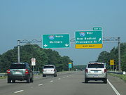
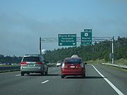
9.4 | 2 | 3 | , Buzzards Bay Buzzards Bay, Massachusetts Buzzards Bay is a census-designated place in the town of Bourne in Barnstable County, Massachusetts. The population was 3,549 at the 2000 census.-Geography:Buzzards Bay is located at... |
West end of Route 28 overlap; Route 28 is unsigned eastbound |
| 10.0 | — Bourne Bridge, Falmouth Falmouth, Massachusetts Falmouth is a town in Barnstable County, Massachusetts, United States; Barnstable County is coextensive with Cape Cod. The population was 31,531 at the 2010 census.... , The Islands Cape Cod and Islands Cape Cod and the Islands is a common local name for the area of southeast Massachusetts including Barnstable , Dukes , and Nantucket Counties, and by some definitions including part or all of the towns of Plymouth and Wareham... |
East end of Route 28 overlap; Route 25 designation ends at US 6 underpass; mainline continues as Route 28 south | ||||
| 10.0 | ||||||