
Bourne, Massachusetts
Encyclopedia
Bourne is a town
in Barnstable County
, Massachusetts
, United States
. The population was 18,721 at the 2000 census.
For geographic and demographic information on specific parts of the town of Bourne, please see the articles on Bourne (CDP)
, Buzzards Bay
, Monument Beach
, Pocasset
, Sagamore
, and Sagamore Beach
.
. It was officially incorporated in 1884 as the last town to be incorporated in Barnstable County. It was named for Jonathan Bourne Sr., whose father, Richard Bourne, served in the Massachusetts General Court at the time of settlement, as well as helping to found the settlement in Mashpee. The town lies at the northeast corner of Buzzards Bay
, and is the site of Aptucxet Trading Post, the nation's oldest store. It was founded by the Pilgrims in 1627 at a site halfway between the two rivers which divided the Cape from the rest of the state. It was out of this location that the Cape Cod Canal
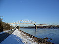
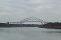
was formed, in order to save time and lives by eliminating the need to sail around the hazardous eastern shores of Cape Cod. Because of the canal, Bourne is now considered the "first" town on the Cape, as all three bridges (the Bourne, Sagamore
and the Cape Cod Canal Railroad Bridge
) are located within the town. All of Bourne is on Cape Cod, with Buttermilk bay forming the western edge of the peninsula (cape) and the Bourndale Road forming the northern boundary to the cape.
Bourne is also the site of the Massachusetts Maritime Academy
, a maritime college located at the southern mouth of the canal on the western shore.
Otis Air National Guard Base
is also partially located in the town. The United States Air Force space command system PAVE PAWS
northeast radar is located with in Bourne's borders inside of Otis Air National Guard Base.
Bourne is home to an archaeological curiosity known as the "Bourne Stone
", a stone featuring markings whose origin and significance have not been conclusively established.
 According to the United States Census Bureau
, the town has a total area of 52.8 square miles (136.8 km²), of which, 40.9 square miles (106.0 km²) of it is land and 11.9 square miles (30.8 km²) of it (22.53%) is water. Bourne is bordered by Sandwich to the east, Falmouth
to the south, Wareham
to the west, and Plymouth and Cape Cod Bay
to the north. The town lies approximately twenty miles west of Barnstable
, fifty-five miles south-southeast of Boston, and equidistantly from Providence, Rhode Island
. The border with Plymouth and Wareham in Plymouth County constitutes the only landed border between Barnstable County and any other county (the borders with Dukes
and Nantucket
lie in Nantucket Sound
). Major localities of Bourne include Bournedale and Buzzards Bay
on the West side of the Cape Cod Canal, Sagamore
, which straddles the canal, Bourne village, Monument Beach
, Pocasset
, and Cataumet on the East side of the canal.
Bourne's geography was formed around its location on Buzzards Bay
and the Cape Cod Canal
. There are several necks (the local term for a peninsula
) and islands along the shore, which create several small coves and harbors. There are also several small ponds and rivers, all of which (except the Herring River, which feeds directly into the Canal) feed into Buzzards Bay. The largest of these, Buttermilk Bay, lies along the border with Wareham. Also, because of the large parcel of land occupied by Otis A.N.G.B., the majority of settlement is either along the shores of the Canal or along Buzzards Bay. There is also a small neighborhood (South Sagamore) located between the Canal and the northern boundaries of the base. The town also has a town forest and a small portion of the Shawme-Crowell State Forest
(which is located along Otis's northern boundary). There are also many beaches along its shores, mostly along Buzzards Bay (although Sagamore Beach lies along Cape Cod Bay).
of 2000, there were 18,721 people, 7,439 households, and 5,013 families residing in the town. The population density
was 457.6 people per square mile (176.7/km²). There were 9,648 housing units at an average density of 235.8 per square mile (91.1/km²). The racial makeup of the town was 94.72% White, 1.39% Black or African American
, 0.53% Native American, 0.71% Asian, 0.01% Pacific Islander, 0.99% from other races
, and 1.65% from two or more races. Hispanic or Latino of any race were 1.46% of the population.
There were 7,439 households out of which 28.2% had children under the age of 18 living with them, 54.6% were married couples
living together, 9.4% had a female householder with no husband present, and 32.6% were non-families. 26.8% of all households were made up of individuals and 11.8% had someone living alone who was 65 years of age or older. The average household size was 2.39 and the average family size was 2.90.
In the town the population was spread out with 21.9% under the age of 18, 9.4% from 18 to 24, 27.3% from 25 to 44, 23.8% from 45 to 64, and 17.6% who were 65 years of age or older. The median age was 39 years. For every 100 females there were 97.1 males. For every 100 females age 18 and over, there were 95.9 males.
The median income for a household in the town was $45,113, and the median income for a family was $51,603. Males had a median income of $40,217 versus $28,163 for females. The per capita income
for the town was $22,092. About 5.8% of families and 7.1% of the population were below the poverty line, including 10.4% of those under age 18 and 4.7% of those age 65 or over.
Sources: Massachusetts Institute for Social and Economic Research and U.S. Census Bureau, Population Division
 Bourne is represented in the Massachusetts House of Representatives
as a part of three separate districts, the Second Plymouth, Fifth Barnstable, and a third district which includes portions of Falmouth and Mashpee. The town is represented in the Massachusetts Senate
as a part of the Plymouth and Barnstable district, which includes Falmouth, Kingston, Pembroke, Plymouth, Plympton, Sandwich and portions of Barnstable. The town is home to the Seventh Barracks of Troop D of the Massachusetts State Police
.
On the national level, Bourne is a part of Massachusetts's 10th congressional district
, and is currently represented by Bill Delahunt
. The state's senior (Class I) member of the United States Senate
, re-elected in 2008, is John Kerry
. The junior (Class II) Senator, Scott Brown
, was elected January 19, 2010 in a special election to fill the vacancy created by the death of Ted Kennedy
.
The town uses the open town meeting
form of government, which is led by a board of selectmen
. The town hall, like the police station, lies on the mainland side of the Canal. There are four fire stations located throughout the town, and seven post offices for the town's eight ZIP code
s. The town's Jonathan Bourne Library
is located near the Aptucxet Trading Post, just south of the Bourne Bridge, and is a member of the Cape Libraries Automated Materials Sharing
library network.
operates grades nine through twelve. The school's colors are purple and white, and their teams are the Canalmen and Lady Canalmen. Their logo includes the Railroad Bridge, one of the three bridges crossing the Cape Cod Canal
, and the only one that looks different from the other two. Bourne's chief rival is Wareham High School
.
Bourne High School's sports teams have been very successful in the recent past, including state championships in boy's hockey and girl's volleyball. State finalists include girl's volleyball, golf, and boy's soccer. Conference championships have been won by boy's tennis, soccer, and football. The baseball team recently performed very well in the 2007 MIAA State Tournament, losing to Cape-rival Harwich in the South Finals. Bourne also perennially has a moderately successful ice hockey program.
Additionally, Bourne is home to the Upper Cape Cod Regional Technical School, located off Sandwich Road
. The school serves Bourne, Falmouth and Sandwich on the Cape, as well as Wareham and Marion
(off Cape). The town also has three private schools: Saint Margaret's Regional in Buzzards Bay, a Catholic school which serves grades K-8; The Bridgeview School in Sagamore, a private Montessori
school serving Pre-K through 6th grades; and the Waldorf School of Cape Cod, a Waldorf school located just south of the Bourne Bridge, serving grades Pre-K through 8. The Massachusetts Maritime Academy
, a state maritime college, is also located in Buzzards Bay at the western mouth of the Cape Cod Canal.
, Route 25 and Route 28. Routes 6 and 28 enter the town concurrently from Wareham, bypassing Buzzards Bay
to the north. At the Buzzards Bay Rotary the two routes split. Route 6 goes straight ahead and assumes its old alignment as a four-lane highway along the north side of the Cape Cod Canal
, going through the village of Bournedale before becoming the Mid-Cape Highway, a four-lane limited-access highway beginning at the western approach to the Sagamore Bridge
. Sandwich Road
, the road parallel to Route 6 running along the south side of the canal, was formerly signed as Route 6W. Currently it is an unsigned two-lane state highway
that is used as an alternate to Route 6. Sandwich Road becomes Route 6A east of the intersection with Cranberry Highway, a road that acts as a connector between Route 6A and Route 6 eastbound prior to the approach of the Sagamore Bridge. Route 28 splits off at the Buzzards Bay Rotary as a ramp headed to the Bourne Bridge and Route 25. Route 25's terminus is just prior to the northern approach of the Bourne Bridge where the highway continues as Route 28 south. At the southern end of the bridge is the Bourne Rotary, where Sandwich Road intersects. Route 28 continues past the rotary as a four-lane divided highway, officially known as McArthur Boulevard. At the Otis Rotary, the intersection with the road leading to the main gate to Otis Air Force Base, Route 28A spurs off and heads towards Woods Hole in Falmouth. It is also at this point that the highway goes from being a surface road to a true limited-access highway. Route 3, also known as the Pilgrims Highway, ends at the junction of Route 6, just prior to the Sagamore Bridge. Up until 2006 the intersection was a rotary which caused daily traffic nightmares during the busy summer tourist season. The rotary was removed in 2007.
The third bridge over the Canal is the vertical lift railroad bridge
, which brings the railroad to the Cape. Although traffic along this railroad line no longer reaches the lower Cape, as it originally did, it still brings rail traffic to the upper and mid-Cape. Freight rail service is provided by the Massachusetts Coastal Railroad
. The Cape Cod Central Railroad
operates seasonal tourist excursions from Hyannis
to Sagamore
, with occasional special excursions to Buzzards Bay village
. The nearest inter-city (Amtrak
) passenger rail stations are Providence
and Boston's South Station
. Nearby are the Middleborough/Lakeville
and Kingston/Route 3
stations of the MBTA's
commuter rail
system, providing direct service to Boston.
There are no public air facilities in town; the town is roughly equidistantly located between the Plymouth
and Barnstable
municipal airports. The nearest national and international airports are Logan International Airport
in Boston and T. F. Green Airport
outside Providence, RI. Additionally, there are ferry services
to the islands in neighboring Falmouth.
New England town
The New England town is the basic unit of local government in each of the six New England states. Without a direct counterpart in most other U.S. states, New England towns are conceptually similar to civil townships in other states, but are incorporated, possessing powers like cities in other...
in Barnstable County
Barnstable County, Massachusetts
Barnstable County is a county located in the U.S. state of Massachusetts, consisting of Cape Cod and associated islands. As of the 2010 census, the population was 216,902...
, Massachusetts
Massachusetts
The Commonwealth of Massachusetts is a state in the New England region of the northeastern United States of America. It is bordered by Rhode Island and Connecticut to the south, New York to the west, and Vermont and New Hampshire to the north; at its east lies the Atlantic Ocean. As of the 2010...
, United States
United States
The United States of America is a federal constitutional republic comprising fifty states and a federal district...
. The population was 18,721 at the 2000 census.
For geographic and demographic information on specific parts of the town of Bourne, please see the articles on Bourne (CDP)
Bourne (CDP), Massachusetts
Bourne is a census-designated place in the town of Bourne in Barnstable County, Massachusetts, United States. The population was 1,443 at the 2000 census.-Geography:Bourne is located at ....
, Buzzards Bay
Buzzards Bay, Massachusetts
Buzzards Bay is a census-designated place in the town of Bourne in Barnstable County, Massachusetts. The population was 3,549 at the 2000 census.-Geography:Buzzards Bay is located at...
, Monument Beach
Monument Beach, Massachusetts
Monument Beach is a census-designated place in the town of Bourne in Barnstable County, Massachusetts, United States. The population was 2,438 at the 2000 census.-Geography:Monument Beach is located at ....
, Pocasset
Pocasset, Massachusetts
Pocasset is a census-designated place in the town of Bourne in Barnstable County, Massachusetts, United States, located on Buzzards Bay. The population was 2,671 at the 2000 census.-Geography:...
, Sagamore
Sagamore, Massachusetts
Sagamore is a census-designated place in the town of Bourne in Barnstable County, Massachusetts, United States. The population was 3,544 at the 2000 census.-Geography:Sagamore is located at ....
, and Sagamore Beach
Sagamore Beach, Massachusetts
Sagamore Beach is a village of Bourne, Massachusetts fronting Cape Cod Bay and the east end of the Cape Cod Canal. Along with Buzzards Bay, it is one of only two communities in Barnstable County that are north of the Cape Cod Canal....
.
History
Bourne was first settled in 1640 as a part of the town of SandwichSandwich, Massachusetts
Sandwich is a town in Barnstable County, Massachusetts, United States. The population was 20,675 at the 2010 census. The Town Hall is located right next to the Dexter Grist Mill, in the historic district of town....
. It was officially incorporated in 1884 as the last town to be incorporated in Barnstable County. It was named for Jonathan Bourne Sr., whose father, Richard Bourne, served in the Massachusetts General Court at the time of settlement, as well as helping to found the settlement in Mashpee. The town lies at the northeast corner of Buzzards Bay
Buzzards Bay (bay)
Buzzards Bay is a bay of the Atlantic Ocean adjacent to the U.S. state of Massachusetts. It is approximately 28 miles long by 8 miles wide. It is a popular destination for fishing, boating, and tourism. Since 1914, Buzzards Bay has been connected to Cape Cod Bay by the Cape Cod Canal...
, and is the site of Aptucxet Trading Post, the nation's oldest store. It was founded by the Pilgrims in 1627 at a site halfway between the two rivers which divided the Cape from the rest of the state. It was out of this location that the Cape Cod Canal
Cape Cod Canal
The Cape Cod Canal is an artificial waterway traversing the narrow neck of land that joins Cape Cod to mainland Massachusetts.Part of the Atlantic Intracoastal Waterway, the canal is roughly 17.4 miles long and connects Cape Cod Bay in the north to Buzzards Bay in the south...
was formed, in order to save time and lives by eliminating the need to sail around the hazardous eastern shores of Cape Cod. Because of the canal, Bourne is now considered the "first" town on the Cape, as all three bridges (the Bourne, Sagamore
Sagamore Bridge
The Sagamore Bridge in Sagamore, Massachusetts carries U.S. Route 6 across the Cape Cod Canal, connecting Cape Cod with the rest of Massachusetts, USA....
and the Cape Cod Canal Railroad Bridge
Cape Cod Canal Railroad Bridge
- External links :*...
) are located within the town. All of Bourne is on Cape Cod, with Buttermilk bay forming the western edge of the peninsula (cape) and the Bourndale Road forming the northern boundary to the cape.
Bourne is also the site of the Massachusetts Maritime Academy
Massachusetts Maritime Academy
Massachusetts Maritime Academy is a regionally accredited, coeducational, state college offering undergraduate degrees in maritime-related fields, as well as graduate degrees and professional studies. Established in 1891, Mass Maritime is the second oldest state maritime academy in the country...
, a maritime college located at the southern mouth of the canal on the western shore.
Otis Air National Guard Base
Otis Air National Guard Base
Otis Air National Guard Base is an Air National Guard installation located within the Massachusetts Military Reservation , a military training facility, located on the western portion of Cape Cod, in western Barnstable County, Massachusetts, United States...
is also partially located in the town. The United States Air Force space command system PAVE PAWS
PAVE PAWS
PAVE PAWS is a United States Air Force Space Command radar system operated by three 21st Space Wing squadrons for missile warning and space surveillance. Operational PAVE PAWS radars are located at:...
northeast radar is located with in Bourne's borders inside of Otis Air National Guard Base.
Bourne is home to an archaeological curiosity known as the "Bourne Stone
Bourne Stone
The Bourne Stone is an archaeological curiosity located in the town of Bourne, Massachusetts.The object is a 300-pound chunk of pink granite, upon which two lines of carvings were made. For many years it served as the doorstep for a meetinghouse in Bourne...
", a stone featuring markings whose origin and significance have not been conclusively established.
Geography
United States Census Bureau
The United States Census Bureau is the government agency that is responsible for the United States Census. It also gathers other national demographic and economic data...
, the town has a total area of 52.8 square miles (136.8 km²), of which, 40.9 square miles (106.0 km²) of it is land and 11.9 square miles (30.8 km²) of it (22.53%) is water. Bourne is bordered by Sandwich to the east, Falmouth
Falmouth, Massachusetts
Falmouth is a town in Barnstable County, Massachusetts, United States; Barnstable County is coextensive with Cape Cod. The population was 31,531 at the 2010 census....
to the south, Wareham
Wareham, Massachusetts
Wareham is a town located in Plymouth County, Massachusetts. As of the 2000 census, the town had a total population of 20,335, with an estimated 2008 population of 21,221....
to the west, and Plymouth and Cape Cod Bay
Cape Cod Bay
Cape Cod Bay is a large bay of the Atlantic Ocean adjacent to the U.S. state of Massachusetts. Measuring below a line drawn from Brant Rock in Marshfield to Race Point in Provincetown, Massachusetts, it is enclosed by Cape Cod to the south and east, and Plymouth County, Massachusetts, to the west....
to the north. The town lies approximately twenty miles west of Barnstable
Barnstable, Massachusetts
Barnstable is a city, referred to as the Town of Barnstable, in the U.S. state of Massachusetts and the county seat of Barnstable County. Barnstable is the largest community, both in land area and population, on Cape Cod. The town contains seven villages within its boundaries...
, fifty-five miles south-southeast of Boston, and equidistantly from Providence, Rhode Island
Providence, Rhode Island
Providence is the capital and most populous city of Rhode Island and was one of the first cities established in the United States. Located in Providence County, it is the third largest city in the New England region...
. The border with Plymouth and Wareham in Plymouth County constitutes the only landed border between Barnstable County and any other county (the borders with Dukes
Dukes County, Massachusetts
-Demographics:As of the census of 2000, there were 14,987 people, 6,421 households, and 3,788 families residing in the county. The population density was 144 people per square mile . There were 14,836 housing units at an average density of 143 per square mile...
and Nantucket
Nantucket, Massachusetts
Nantucket is an island south of Cape Cod, Massachusetts, in the United States. Together with the small islands of Tuckernuck and Muskeget, it constitutes the town of Nantucket, Massachusetts, and the coterminous Nantucket County, which are consolidated. Part of the town is designated the Nantucket...
lie in Nantucket Sound
Nantucket Sound
Nantucket Sound is a roughly triangular area of the Atlantic Ocean offshore from the U.S. state of Massachusetts. It is long and wide, and is enclosed by Cape Cod on the north, Nantucket on the south, and Martha's Vineyard on the west. Between Cape Cod and Martha's Vineyard it is connected to the...
). Major localities of Bourne include Bournedale and Buzzards Bay
Buzzards Bay, Massachusetts
Buzzards Bay is a census-designated place in the town of Bourne in Barnstable County, Massachusetts. The population was 3,549 at the 2000 census.-Geography:Buzzards Bay is located at...
on the West side of the Cape Cod Canal, Sagamore
Sagamore, Massachusetts
Sagamore is a census-designated place in the town of Bourne in Barnstable County, Massachusetts, United States. The population was 3,544 at the 2000 census.-Geography:Sagamore is located at ....
, which straddles the canal, Bourne village, Monument Beach
Monument Beach, Massachusetts
Monument Beach is a census-designated place in the town of Bourne in Barnstable County, Massachusetts, United States. The population was 2,438 at the 2000 census.-Geography:Monument Beach is located at ....
, Pocasset
Pocasset, Massachusetts
Pocasset is a census-designated place in the town of Bourne in Barnstable County, Massachusetts, United States, located on Buzzards Bay. The population was 2,671 at the 2000 census.-Geography:...
, and Cataumet on the East side of the canal.
Bourne's geography was formed around its location on Buzzards Bay
Buzzards Bay (bay)
Buzzards Bay is a bay of the Atlantic Ocean adjacent to the U.S. state of Massachusetts. It is approximately 28 miles long by 8 miles wide. It is a popular destination for fishing, boating, and tourism. Since 1914, Buzzards Bay has been connected to Cape Cod Bay by the Cape Cod Canal...
and the Cape Cod Canal
Cape Cod Canal
The Cape Cod Canal is an artificial waterway traversing the narrow neck of land that joins Cape Cod to mainland Massachusetts.Part of the Atlantic Intracoastal Waterway, the canal is roughly 17.4 miles long and connects Cape Cod Bay in the north to Buzzards Bay in the south...
. There are several necks (the local term for a peninsula
Peninsula
A peninsula is a piece of land that is bordered by water on three sides but connected to mainland. In many Germanic and Celtic languages and also in Baltic, Slavic and Hungarian, peninsulas are called "half-islands"....
) and islands along the shore, which create several small coves and harbors. There are also several small ponds and rivers, all of which (except the Herring River, which feeds directly into the Canal) feed into Buzzards Bay. The largest of these, Buttermilk Bay, lies along the border with Wareham. Also, because of the large parcel of land occupied by Otis A.N.G.B., the majority of settlement is either along the shores of the Canal or along Buzzards Bay. There is also a small neighborhood (South Sagamore) located between the Canal and the northern boundaries of the base. The town also has a town forest and a small portion of the Shawme-Crowell State Forest
Shawme-Crowell State Forest
Shawme-Crowell State Forest is a Massachusetts state park located in Sandwich in Barnstable County. The park is managed by the Department of Conservation and Recreation. Originally the forest was much larger but the creation of Camp Edwards made the forest the small size that it is today...
(which is located along Otis's northern boundary). There are also many beaches along its shores, mostly along Buzzards Bay (although Sagamore Beach lies along Cape Cod Bay).
Demographics
As of the censusCensus
A census is the procedure of systematically acquiring and recording information about the members of a given population. It is a regularly occurring and official count of a particular population. The term is used mostly in connection with national population and housing censuses; other common...
of 2000, there were 18,721 people, 7,439 households, and 5,013 families residing in the town. The population density
Population density
Population density is a measurement of population per unit area or unit volume. It is frequently applied to living organisms, and particularly to humans...
was 457.6 people per square mile (176.7/km²). There were 9,648 housing units at an average density of 235.8 per square mile (91.1/km²). The racial makeup of the town was 94.72% White, 1.39% Black or African American
Race (United States Census)
Race and ethnicity in the United States Census, as defined by the Federal Office of Management and Budget and the United States Census Bureau, are self-identification data items in which residents choose the race or races with which they most closely identify, and indicate whether or not they are...
, 0.53% Native American, 0.71% Asian, 0.01% Pacific Islander, 0.99% from other races
Race (United States Census)
Race and ethnicity in the United States Census, as defined by the Federal Office of Management and Budget and the United States Census Bureau, are self-identification data items in which residents choose the race or races with which they most closely identify, and indicate whether or not they are...
, and 1.65% from two or more races. Hispanic or Latino of any race were 1.46% of the population.
There were 7,439 households out of which 28.2% had children under the age of 18 living with them, 54.6% were married couples
Marriage
Marriage is a social union or legal contract between people that creates kinship. It is an institution in which interpersonal relationships, usually intimate and sexual, are acknowledged in a variety of ways, depending on the culture or subculture in which it is found...
living together, 9.4% had a female householder with no husband present, and 32.6% were non-families. 26.8% of all households were made up of individuals and 11.8% had someone living alone who was 65 years of age or older. The average household size was 2.39 and the average family size was 2.90.
In the town the population was spread out with 21.9% under the age of 18, 9.4% from 18 to 24, 27.3% from 25 to 44, 23.8% from 45 to 64, and 17.6% who were 65 years of age or older. The median age was 39 years. For every 100 females there were 97.1 males. For every 100 females age 18 and over, there were 95.9 males.
The median income for a household in the town was $45,113, and the median income for a family was $51,603. Males had a median income of $40,217 versus $28,163 for females. The per capita income
Per capita income
Per capita income or income per person is a measure of mean income within an economic aggregate, such as a country or city. It is calculated by taking a measure of all sources of income in the aggregate and dividing it by the total population...
for the town was $22,092. About 5.8% of families and 7.1% of the population were below the poverty line, including 10.4% of those under age 18 and 4.7% of those age 65 or over.
Recent population trends
| 1930 | 2,895 |
| 1940 | 3,315 |
| 1950 | 4,720 |
| 1960 | 14,011 |
| 1970 | 12,636 |
| 1980 | 13,874 |
| 1990 | 16,064 |
| 2000 | 18,721 |
| 2002 | 19,372 (estimate) |
Sources: Massachusetts Institute for Social and Economic Research and U.S. Census Bureau, Population Division
Government
Massachusetts House of Representatives
The Massachusetts House of Representatives is the lower house of the Massachusetts General Court, the state legislature of the Commonwealth of Massachusetts. It is composed of 160 members elected from single-member electoral districts across the Commonwealth. Representatives serve two-year terms...
as a part of three separate districts, the Second Plymouth, Fifth Barnstable, and a third district which includes portions of Falmouth and Mashpee. The town is represented in the Massachusetts Senate
Massachusetts Senate
The Massachusetts Senate is the upper house of the Massachusetts General Court, the bicameral state legislature of the Commonwealth of Massachusetts. The Senate comprises 40 elected members from 40 single-member senatorial districts in the state...
as a part of the Plymouth and Barnstable district, which includes Falmouth, Kingston, Pembroke, Plymouth, Plympton, Sandwich and portions of Barnstable. The town is home to the Seventh Barracks of Troop D of the Massachusetts State Police
Massachusetts State Police
The Massachusetts State Police is an agency of the Commonwealth of Massachusetts' Executive Office of Public Safety and Security responsible for criminal law enforcement and traffic vehicle regulation across the state...
.
On the national level, Bourne is a part of Massachusetts's 10th congressional district
Massachusetts's 10th congressional district
Massachusetts's 10th congressional district is a political constituency that includes parts of the South Shore of Massachusetts, and all of Cape Cod and the islands. With a population of 635,901 and a land area of , it is the most populous of Massachusetts's ten congressional districts and the...
, and is currently represented by Bill Delahunt
Bill Delahunt
William D. Delahunt is a former U.S. Representative for , serving from 1997 to 2011. He is a member of the Democratic Party. Delahunt did not seek re-election in 2010, and left Congress in January 2011. He was replaced by Norfolk County District Attorney Bill Keating...
. The state's senior (Class I) member of the United States Senate
United States Senate
The United States Senate is the upper house of the bicameral legislature of the United States, and together with the United States House of Representatives comprises the United States Congress. The composition and powers of the Senate are established in Article One of the U.S. Constitution. Each...
, re-elected in 2008, is John Kerry
John Kerry
John Forbes Kerry is the senior United States Senator from Massachusetts, the 10th most senior U.S. Senator and chairman of the Senate Foreign Relations Committee. He was the presidential nominee of the Democratic Party in the 2004 presidential election, but lost to former President George W...
. The junior (Class II) Senator, Scott Brown
Scott Brown
Scott Brown is a United States senator.Scott Brown may also refer to:-Sportsmen:*Scott Brown , American college football coach of Kentucky State...
, was elected January 19, 2010 in a special election to fill the vacancy created by the death of Ted Kennedy
Ted Kennedy
Edward Moore "Ted" Kennedy was a United States Senator from Massachusetts and a member of the Democratic Party. Serving almost 47 years, he was the second most senior member of the Senate when he died and is the fourth-longest-serving senator in United States history...
.
The town uses the open town meeting
Open town meeting
An open town meeting is a form of town meeting in which all registered voters of a town may vote . This form of government is typical of smaller municipalities in the New England region of the United States....
form of government, which is led by a board of selectmen
Board of selectmen
The board of selectmen is commonly the executive arm of the government of New England towns in the United States. The board typically consists of three or five members, with or without staggered terms.-History:...
. The town hall, like the police station, lies on the mainland side of the Canal. There are four fire stations located throughout the town, and seven post offices for the town's eight ZIP code
ZIP Code
ZIP codes are a system of postal codes used by the United States Postal Service since 1963. The term ZIP, an acronym for Zone Improvement Plan, is properly written in capital letters and was chosen to suggest that the mail travels more efficiently, and therefore more quickly, when senders use the...
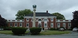
s. The town's Jonathan Bourne Library
Jonathan Bourne Public Library
The Jonathan Bourne Public Library is a public library in Bourne, Massachusetts. Prior to 1891, the town lacked a public library. The Bourne library was named in honor of Jonathan Bourne , who was a New Bedford alderman, major investor in the whaling business, member of executive councils of...
is located near the Aptucxet Trading Post, just south of the Bourne Bridge, and is a member of the Cape Libraries Automated Materials Sharing
Cape Libraries Automated Materials Sharing
The Cape Libraries Automated Materials Sharing network is a non-profit, cooperative association of thirty-two member libraries and thirty-five locations located throughout Cape Cod, Martha's Vineyard, and Nantucket...
library network.
| Voter Registration and Party Enrollment as of October 15, 2008 | |||||||||||||||
|---|---|---|---|---|---|---|---|---|---|---|---|---|---|---|---|
| Party | Number of Voters | Percentage |
Democratic Democratic Party (United States) The Democratic Party is one of two major contemporary political parties in the United States, along with the Republican Party. The party's socially liberal and progressive platform is largely considered center-left in the U.S. political spectrum. The party has the lengthiest record of continuous... |
3,027 | 23.29% |
Republican Republican Party (United States) The Republican Party is one of the two major contemporary political parties in the United States, along with the Democratic Party. Founded by anti-slavery expansion activists in 1854, it is often called the GOP . The party's platform generally reflects American conservatism in the U.S... |
2,080 | 16.00% |
Unaffiliated | 7,829 | 60.24% |
Minor Parties | 60 | 0.46% | |
| Total | 12,996 | 100% | |||||||||||||
Education
Bourne operates its own school department, with six public schools in the town. There are three elementary schools, Ella F. Hoxie, James F. Peebles, Bourndale Elementary School and the Otis Memorial Elementary School. All three serve grades one through four, with Otis and Bournedale being the only two schools to host kindergarten and pre-kindergarten classes. The town's middle school serves grades five through eight, and Bourne High SchoolBourne High School
Bourne High School is a public high school located in Bourne, Massachusetts. The school serves roughly 900 students in grades 9-12 that reside in the town of Bourne.-History:...
operates grades nine through twelve. The school's colors are purple and white, and their teams are the Canalmen and Lady Canalmen. Their logo includes the Railroad Bridge, one of the three bridges crossing the Cape Cod Canal
Cape Cod Canal
The Cape Cod Canal is an artificial waterway traversing the narrow neck of land that joins Cape Cod to mainland Massachusetts.Part of the Atlantic Intracoastal Waterway, the canal is roughly 17.4 miles long and connects Cape Cod Bay in the north to Buzzards Bay in the south...
, and the only one that looks different from the other two. Bourne's chief rival is Wareham High School
Wareham High School
Wareham High School is a public high school located in Wareham, Massachusetts. The school is a part of the Wareham Public School system, and serves roughly 900 students in grades 9-12....
.
Bourne High School's sports teams have been very successful in the recent past, including state championships in boy's hockey and girl's volleyball. State finalists include girl's volleyball, golf, and boy's soccer. Conference championships have been won by boy's tennis, soccer, and football. The baseball team recently performed very well in the 2007 MIAA State Tournament, losing to Cape-rival Harwich in the South Finals. Bourne also perennially has a moderately successful ice hockey program.
Additionally, Bourne is home to the Upper Cape Cod Regional Technical School, located off Sandwich Road
Sandwich Road (Bourne)
Sandwich Road is a two-lane state highway in Bourne, Massachusetts, United States, running from Bourne center east to Sandwich. It begins at a four-way intersection with Shore Road, County Road and Trowbridge Road in Bourne center; Waterhouse Road and Perry Avenue also once ended there...
. The school serves Bourne, Falmouth and Sandwich on the Cape, as well as Wareham and Marion
Marion, Massachusetts
Marion is a town in Plymouth County, Massachusetts, United States. The population was 5,123 at the 2000 census.For geographic and demographic information on the village of Marion Center, please see the article Marion Center, Massachusetts.-History:...
(off Cape). The town also has three private schools: Saint Margaret's Regional in Buzzards Bay, a Catholic school which serves grades K-8; The Bridgeview School in Sagamore, a private Montessori
Montessori method
Montessori education is an educational approach developed by Italian physician and educator Maria Montessori. Montessori education is practiced in an estimated 20,000 schools worldwide, serving children from birth to eighteen years old.-Overview:...
school serving Pre-K through 6th grades; and the Waldorf School of Cape Cod, a Waldorf school located just south of the Bourne Bridge, serving grades Pre-K through 8. The Massachusetts Maritime Academy
Massachusetts Maritime Academy
Massachusetts Maritime Academy is a regionally accredited, coeducational, state college offering undergraduate degrees in maritime-related fields, as well as graduate degrees and professional studies. Established in 1891, Mass Maritime is the second oldest state maritime academy in the country...
, a state maritime college, is also located in Buzzards Bay at the western mouth of the Cape Cod Canal.
Transportation
There are no interstate highways at all on Cape Cod. As such, the largest highways in Bourne are Route 3, U.S. Route 6U.S. Route 6
U.S. Route 6 , also called the Grand Army of the Republic Highway, a name that honors an American Civil War veterans association, is a main route of the U.S. Highway system, running east-northeast from Bishop, California to Provincetown, Massachusetts. Until 1964, it continued south from Bishop to...
, Route 25 and Route 28. Routes 6 and 28 enter the town concurrently from Wareham, bypassing Buzzards Bay
Buzzards Bay, Massachusetts
Buzzards Bay is a census-designated place in the town of Bourne in Barnstable County, Massachusetts. The population was 3,549 at the 2000 census.-Geography:Buzzards Bay is located at...
to the north. At the Buzzards Bay Rotary the two routes split. Route 6 goes straight ahead and assumes its old alignment as a four-lane highway along the north side of the Cape Cod Canal
Cape Cod Canal
The Cape Cod Canal is an artificial waterway traversing the narrow neck of land that joins Cape Cod to mainland Massachusetts.Part of the Atlantic Intracoastal Waterway, the canal is roughly 17.4 miles long and connects Cape Cod Bay in the north to Buzzards Bay in the south...
, going through the village of Bournedale before becoming the Mid-Cape Highway, a four-lane limited-access highway beginning at the western approach to the Sagamore Bridge
Sagamore Bridge
The Sagamore Bridge in Sagamore, Massachusetts carries U.S. Route 6 across the Cape Cod Canal, connecting Cape Cod with the rest of Massachusetts, USA....
. Sandwich Road
Sandwich Road (Bourne)
Sandwich Road is a two-lane state highway in Bourne, Massachusetts, United States, running from Bourne center east to Sandwich. It begins at a four-way intersection with Shore Road, County Road and Trowbridge Road in Bourne center; Waterhouse Road and Perry Avenue also once ended there...
, the road parallel to Route 6 running along the south side of the canal, was formerly signed as Route 6W. Currently it is an unsigned two-lane state highway
State highway
State highway, state road or state route can refer to one of three related concepts, two of them related to a state or provincial government in a country that is divided into states or provinces :#A...
that is used as an alternate to Route 6. Sandwich Road becomes Route 6A east of the intersection with Cranberry Highway, a road that acts as a connector between Route 6A and Route 6 eastbound prior to the approach of the Sagamore Bridge. Route 28 splits off at the Buzzards Bay Rotary as a ramp headed to the Bourne Bridge and Route 25. Route 25's terminus is just prior to the northern approach of the Bourne Bridge where the highway continues as Route 28 south. At the southern end of the bridge is the Bourne Rotary, where Sandwich Road intersects. Route 28 continues past the rotary as a four-lane divided highway, officially known as McArthur Boulevard. At the Otis Rotary, the intersection with the road leading to the main gate to Otis Air Force Base, Route 28A spurs off and heads towards Woods Hole in Falmouth. It is also at this point that the highway goes from being a surface road to a true limited-access highway. Route 3, also known as the Pilgrims Highway, ends at the junction of Route 6, just prior to the Sagamore Bridge. Up until 2006 the intersection was a rotary which caused daily traffic nightmares during the busy summer tourist season. The rotary was removed in 2007.
The third bridge over the Canal is the vertical lift railroad bridge
Cape Cod Canal Railroad Bridge
- External links :*...
, which brings the railroad to the Cape. Although traffic along this railroad line no longer reaches the lower Cape, as it originally did, it still brings rail traffic to the upper and mid-Cape. Freight rail service is provided by the Massachusetts Coastal Railroad
Massachusetts Coastal Railroad
The Massachusetts Coastal Railroad is the successor operator of portions of Bay Colony Railroad.-History:On December 31, 2007 the contract to operate the freight railroad lines owned by the Commonwealth of Massachusetts administered by the Executive Office of Transportation expired. These...
. The Cape Cod Central Railroad
Cape Cod Central Railroad
The Cape Cod Central Railroad is a heritage railroad located in Cape Cod, Massachusetts.Originally founded in 1999, it operates a variety of excursion trains from downtown Hyannis to the Cape Cod Canal during spring, summer, and fall. Recently, it has expanded service in a limited capacity to offer...
operates seasonal tourist excursions from Hyannis
Hyannis, Massachusetts
Hyannis is the largest of seven villages in Barnstable, Massachusetts. Also it is the commercial and transportation hub of Cape Cod and was designated an urban area as a result of the 1990 census. Because of this, many refer to Hyannis as the "Capital of the Cape"...
to Sagamore
Sagamore, Massachusetts
Sagamore is a census-designated place in the town of Bourne in Barnstable County, Massachusetts, United States. The population was 3,544 at the 2000 census.-Geography:Sagamore is located at ....
, with occasional special excursions to Buzzards Bay village
Buzzards Bay, Massachusetts
Buzzards Bay is a census-designated place in the town of Bourne in Barnstable County, Massachusetts. The population was 3,549 at the 2000 census.-Geography:Buzzards Bay is located at...
. The nearest inter-city (Amtrak
Amtrak
The National Railroad Passenger Corporation, doing business as Amtrak , is a government-owned corporation that was organized on May 1, 1971, to provide intercity passenger train service in the United States. "Amtrak" is a portmanteau of the words "America" and "track". It is headquartered at Union...
) passenger rail stations are Providence
Providence (Amtrak station)
Providence Station is a railroad station in Providence, Rhode Island and is served by Amtrak and the Massachusetts Bay Transportation Authority . The station has four tracks for passenger service, with a fifth track passing through for Providence and Worcester Railroad freight trains...
and Boston's South Station
South Station
South Station, New England's second-largest transportation center , located at the intersection of Atlantic Avenue and Summer Street in Dewey Square, Boston, Massachusetts, is the largest train station and intercity bus terminal in Greater Boston, a prominent train station in the northeastern...
. Nearby are the Middleborough/Lakeville
Middleborough/Lakeville (MBTA station)
Middleborough/Lakeville is an MBTA Commuter Rail station in Lakeville, Massachusetts. It is the terminus of the Middleborough/Lakeville Line. Middleborough/Lakeville Station was built on a line that was once part of the original Fall River Railroad, which actually had two different stations for...
and Kingston/Route 3
Kingston (MBTA station)
Kingston / Route 3 is a passenger rail station on MBTA Commuter Rail's Plymouth/Kingston Line. it is located at 194 Marion Drive in Kingston, Massachusetts, which is west of Independence Mall Shopping Center off of Exit 8 on Massachusetts Route 3, hence the dual name.Kingston station was built in...
stations of the MBTA's
Massachusetts Bay Transportation Authority
The Massachusetts Bay Transportation Authority, often referred to as the MBTA or simply The T, is the public operator of most bus, subway, commuter rail and ferry systems in the greater Boston, Massachusetts, area. Officially a "body politic and corporate, and a political subdivision" of the...
commuter rail
MBTA Commuter Rail
The MBTA Commuter Rail serves as the regional rail arm of the Massachusetts Bay Transportation Authority, in the United States. It is operated under contract by the Massachusetts Bay Commuter Railroad Company a joint partnership of Veolia Transportation, Bombardier Transportation and Alternate...
system, providing direct service to Boston.
There are no public air facilities in town; the town is roughly equidistantly located between the Plymouth
Plymouth Municipal Airport (Massachusetts)
Plymouth Municipal Airport is a town-owned, public-use airport located four nautical miles southwest of the central business district of Plymouth, a town in Plymouth County, Massachusetts, United States...
and Barnstable
Barnstable Municipal Airport
Barnstable Municipal Airport , also known as Boardman/Polando Field, is a public airport located on Cape Cod, one mile north of the central business district of Hyannis, in Barnstable County, Massachusetts, United States. This airport is publicly owned by Town of Barnstable...
municipal airports. The nearest national and international airports are Logan International Airport
Logan International Airport
General Edward Lawrence Logan International Airport is located in the East Boston neighborhood of Boston, Massachusetts . It covers , has six runways, and employs an estimated 16,000 people. It is the 19th busiest airport in the United States.Boston serves as a focus city for JetBlue Airways...
in Boston and T. F. Green Airport
T. F. Green Airport
T. F. Green Airport , also known as Theodore Francis Green State Airport, is a public airport located in Warwick, six miles south of Providence, in Kent County, Rhode Island, USA. Dedicated in 1931, the airport was named for former Rhode Island governor and longtime senator Theodore F. Green...
outside Providence, RI. Additionally, there are ferry services
The Woods Hole, Martha's Vineyard and Nantucket Steamship Authority
The Woods Hole, Martha's Vineyard and Nantucket Steamship Authority, referred to coloquially as The Steamship Authority or simply the SSA, is the statutory regulatory body for all ferry operations to and from the Islands from the Massachusetts mainland, as well as being an operator of ferry service...
to the islands in neighboring Falmouth.
Notable residents
- Thomas Akins, Mayor (unofficial), Beer expert, local folklorian
- Peter GammonsPeter GammonsPeter Gammons is an American sportswriter, media personality, and a recipient of the J. G. Taylor Spink Award for outstanding baseball writing, given by the BBWAA.-Education:...
, sportswriter - Mark FayneMark FayneMark C. Fayne is an American professional ice hockey player who is currently playing for the New Jersey Devils of the National Hockey League...
, NHL - Robert KraftRobert KraftRobert K. Kraft is an American business magnate. He is the Chairman and was the Chief Executive Officer of The Kraft Group, a diversified holding company with assets in paper and packaging, sports and entertainment, real estate development and a private equity portfolio...
, Owner of New England Patriots