
Ross and Cromarty
Encyclopedia
Ross and Cromarty is a variously defined area in the Highlands and Islands
of Scotland
. There is a registration county
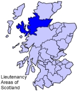
and a lieutenancy area
in current use. Historically there has been a constituency
of the Parliament of the United Kingdom
(1832 to 1983), a local government county
(1890 to 1975), a district of the Highland
local government region
(1975 to 1996) and a management area of the Highland Council (1996 to 2007). The local government county is now divided between two local government areas: the Highland
area and Na h-Eileanan Siar (the Western Isles).
The region has some of the most spectacular landscapes, and among the oldest rock formation
s in Europe. The rocks are of Cambrian
and Precambrian
age. The population is very low, being mainly engaged in fishing
and tourism
. Crofting
is widespread.
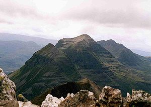 The district is famous for its mountainous scenery, especially in the west, in an area known as Wester Ross
. It includes the Torridon Hills
composed of Precambrian
Torridonian sandstone over Lewisian gneiss
, and capped by Cambrian
quartzite
. The latter rocks often give the appearance of a snow topping when they cap a specific peak. The Torridons comprise individual mountains such as Beinn Eighe
and Liathach
, with related peaks Slioch
and An Teallach
to the north. Although many peaks in the North-west highlands exhibit Torridon geology
, the Torridon hills are generally considered only to be those in the Torridon Forest to the north of Glen Torridon. Specifically, these are:
Hills between Glen Torridon and Strath Carron share much of the splendour and character of the main hills, although perhaps less of the drama:
The Torridon Hills exhibit some of the most dramatic mountain scenery in the British Isles
, surpassed in grandeur probably only by the Cuillins of Skye
. The black Cuillins are composed of volcanic gabbro
, and probably represent the remains of a caldera
or collapsed volcano. Accessible peaks include Sgurr Alasdair
in the west and Sgurr nan Gillean
in the east. The red Cuillin to the south is composed of granite
.
of the Parliament of the United Kingdom
from 1832 to 1983. As created in 1832, the constituency merged two former county constituencies: the Ross-shire constituency
and the Cromartyshire constituency, and it elected a Member of Parliament
to represent the counties of Ross-shire
and Cromartyshire
, minus their parliamentary burghs, Dingwall
, Tain
and Fortrose
, which were represented as components of the Wick burghs constituency and the Inverness burghs constituency.
Constituency boundaries were altered in 1918, by the Representation of the People Act 1918
, and the Ross and Cromarty constituency acquired the boundaries of the county of Ross and Cromarty, including the former parliamentary burghs, but minus Stornoway
and Lewis
, which became a new constituency, the Western Isles constituency.
In 1983, the Ross, Cromarty and Skye constituency
was created to represent the then Ross and Cromarty district and Skye and Lochalsh
district. The Kincardine
area joined the Caithness and Sutherland constituency
.
, with boundaries similar to, but not exactly the same as, the boundaries of the constituency. The county continued with largely unchanged boundaries until its abolition in 1975.
When the county was abolished in 1975, the mainland part became part of the new Highland Region, and Lewis became part of the Western Isles islands area.
district and the Kincardine
area joined the Sutherland
district. The district was abolished in 1996.
, the monarch's representatives. The Ross and Cromarty lieutenancy area combines the areas of two former districts of the Highland region: Ross and Cromarty, and Skye and Lochalsh. The area therefore includes the mainland part of the registration county and former administrative county of Ross and Cromarty, excluding Kincardine, with the addition of the Isle of Skye, which is in the registration county (and former administrative county) of Inverness-shire
.
Highlands and Islands
The Highlands and Islands of Scotland are broadly the Scottish Highlands plus Orkney, Shetland and the Hebrides.The Highlands and Islands are sometimes defined as the area to which the Crofters' Act of 1886 applied...
of Scotland
Scotland
Scotland is a country that is part of the United Kingdom. Occupying the northern third of the island of Great Britain, it shares a border with England to the south and is bounded by the North Sea to the east, the Atlantic Ocean to the north and west, and the North Channel and Irish Sea to the...
. There is a registration county
Registration county
A registration county was, in Great Britain and Ireland, a statistical unit used for the registration of births, deaths and marriages and for the output of census information. In Scotland registration counties are used for land registration purposes....
and a lieutenancy area
Lieutenancy areas of Scotland
The lieutenancy areas of Scotland are the areas used for the ceremonial lord-lieutenants, the monarch's representatives, in Scotland. They are different from the local government council areas, the committee areas, the sheriffdoms, the registration counties, the former regions and districts, the...
in current use. Historically there has been a constituency
United Kingdom constituencies
In the United Kingdom , each of the electoral areas or divisions called constituencies elects one or more members to a parliament or assembly.Within the United Kingdom there are now five bodies with members elected by constituencies:...
of the Parliament of the United Kingdom
Parliament of the United Kingdom
The Parliament of the United Kingdom of Great Britain and Northern Ireland is the supreme legislative body in the United Kingdom, British Crown dependencies and British overseas territories, located in London...
(1832 to 1983), a local government county
Counties of Scotland
The counties of Scotland were the principal local government divisions of Scotland until 1975. Scotland's current lieutenancy areas and registration counties are largely based on them. They are often referred to as historic counties....
(1890 to 1975), a district of the Highland
Highland (council area)
Highland is a council area in the Scottish Highlands and is the largest local government area in both Scotland and the United Kingdom as a whole. It shares borders with the council areas of Moray, Aberdeenshire, Perth and Kinross, and Argyll and Bute. Their councils, and those of Angus and...
local government region
Regions and districts of Scotland
The local government areas of Scotland were redefined by the Local Government Act 1973 and redefined again by the Local Government etc Act 1994....
(1975 to 1996) and a management area of the Highland Council (1996 to 2007). The local government county is now divided between two local government areas: the Highland
Highland (council area)
Highland is a council area in the Scottish Highlands and is the largest local government area in both Scotland and the United Kingdom as a whole. It shares borders with the council areas of Moray, Aberdeenshire, Perth and Kinross, and Argyll and Bute. Their councils, and those of Angus and...
area and Na h-Eileanan Siar (the Western Isles).
The region has some of the most spectacular landscapes, and among the oldest rock formation
Rock formation
This is a list of rock formations that include isolated, scenic, or spectacular surface rock outcrops. These formations are usually the result of weathering and erosion sculpting the existing rock...
s in Europe. The rocks are of Cambrian
Cambrian
The Cambrian is the first geological period of the Paleozoic Era, lasting from Mya ; it is succeeded by the Ordovician. Its subdivisions, and indeed its base, are somewhat in flux. The period was established by Adam Sedgwick, who named it after Cambria, the Latin name for Wales, where Britain's...
and Precambrian
Precambrian
The Precambrian is the name which describes the large span of time in Earth's history before the current Phanerozoic Eon, and is a Supereon divided into several eons of the geologic time scale...
age. The population is very low, being mainly engaged in fishing
Fishing
Fishing is the activity of trying to catch wild fish. Fish are normally caught in the wild. Techniques for catching fish include hand gathering, spearing, netting, angling and trapping....
and tourism
Tourism
Tourism is travel for recreational, leisure or business purposes. The World Tourism Organization defines tourists as people "traveling to and staying in places outside their usual environment for not more than one consecutive year for leisure, business and other purposes".Tourism has become a...
. Crofting
Crofting
Crofting is a form of land tenure and small-scale food production unique to the Scottish Highlands, the Islands of Scotland, and formerly on the Isle of Man....
is widespread.
Landscape
Wester Ross
is a western area of Ross and Cromarty in Scotland, notably containing the villages on the west coast such as:* Lochcarron* Applecross* Shieldaig* Torridon* Kinlochewe * * * Aultbea* Laide* Ullapool* Achiltibuie...
. It includes the Torridon Hills
Torridon Hills
The Torridon Hills surround Torridon village in the Northwest Highlands of Scotland. The name is usually applied to the mountains to the north of Glen Torridon...
composed of Precambrian
Precambrian
The Precambrian is the name which describes the large span of time in Earth's history before the current Phanerozoic Eon, and is a Supereon divided into several eons of the geologic time scale...
Torridonian sandstone over Lewisian gneiss
Lewisian complex
The Lewisian complex or Lewisian Gneiss is a suite of Precambrian metamorphic rocks that outcrop in the northwestern part of Scotland, forming part of the Hebridean Terrane. These rocks are of Archaean and Paleoproterozoic age, ranging from 3.0–1.7 Ga. They form the basement on which the...
, and capped by Cambrian
Cambrian
The Cambrian is the first geological period of the Paleozoic Era, lasting from Mya ; it is succeeded by the Ordovician. Its subdivisions, and indeed its base, are somewhat in flux. The period was established by Adam Sedgwick, who named it after Cambria, the Latin name for Wales, where Britain's...
quartzite
Quartzite
Quartzite is a hard metamorphic rock which was originally sandstone. Sandstone is converted into quartzite through heating and pressure usually related to tectonic compression within orogenic belts. Pure quartzite is usually white to gray, though quartzites often occur in various shades of pink...
. The latter rocks often give the appearance of a snow topping when they cap a specific peak. The Torridons comprise individual mountains such as Beinn Eighe
Beinn Eighe
Beinn Eighe is a complex mountain massif in the Torridon area of the Highlands of Scotland. It forms a long ridge with many spurs and summits, two of which are classified as Munros. The name Beinn Eighe comes from the Scottish Gaelic meaning File Mountain...
and Liathach
Liathach
Liathach is one of the most famous of the Torridon Hills. It lies to the north of the A896 road, in the Northwest Highlands of Scotland, and has two peaks of Munro status: Spidean a' Choire Leith at the east of the main ridge, and Mullach an Rathain at the western end of the mountain...
, with related peaks Slioch
Slioch
Slioch is a mountain in the Scottish Highlands situated in Wester Ross, eight kilometres north of the village of Kinlochewe. Slioch reaches a height of 981 metres and towers above the south east end of Loch Maree to give one of the best known and most photographed sights in the Highlands...
and An Teallach
An Teallach
An Teallach is a mountain in Scotland. It lies to the southwest of Dundonnell and overlooks Little Loch Broom, in an area often nicknamed the "great wilderness"...
to the north. Although many peaks in the North-west highlands exhibit Torridon geology
Geology
Geology is the science comprising the study of solid Earth, the rocks of which it is composed, and the processes by which it evolves. Geology gives insight into the history of the Earth, as it provides the primary evidence for plate tectonics, the evolutionary history of life, and past climates...
, the Torridon hills are generally considered only to be those in the Torridon Forest to the north of Glen Torridon. Specifically, these are:
- LiathachLiathachLiathach is one of the most famous of the Torridon Hills. It lies to the north of the A896 road, in the Northwest Highlands of Scotland, and has two peaks of Munro status: Spidean a' Choire Leith at the east of the main ridge, and Mullach an Rathain at the western end of the mountain...
- Beinn EigheBeinn EigheBeinn Eighe is a complex mountain massif in the Torridon area of the Highlands of Scotland. It forms a long ridge with many spurs and summits, two of which are classified as Munros. The name Beinn Eighe comes from the Scottish Gaelic meaning File Mountain...
- Beinn AlliginBeinn AlliginBeinn Alligin one of the classic mountains of the Torridon region of Scotland, lying to the north of Loch Torridon, in the Highlands. The name Beinn Alligin is from the Scottish Gaelic, meaning Jewelled Hill...
- Beinn DeargBeinn Dearg (Torridon)Beinn Dearg is the 4th highest of the Torridon mountains in the highlands of Scotland. Beinn Dearg offers all the typical features of a Torridon hill, with steeply terraced rocky sides dissected by near vertical gullies...
Hills between Glen Torridon and Strath Carron share much of the splendour and character of the main hills, although perhaps less of the drama:
- Beinn Liath MhòrBeinn Liath MhòrBeinn Liath Mhòr is a Scottish mountain situated in the mountainous area between Strath Carron and Glen Torridon in Wester Ross in the Highland region. Geologically Beinn Liath Mhòr is made up of Cambrian quartzite scree and Torridonian sandstones giving the mountain a distinctive colour contrast...
- Sgorr RuadhSgorr RuadhSgorr Ruadh is a mountain situated in the mountainous area between Strath Carron and Glen Torridon in Wester Ross in the Highland Region of Scotland...
- Maol Cheann-deargMaol Cheann-deargMaol Cheann-dearg is a Scottish Mountain situated between Upper Loch Torridon and Loch Carron, in the Coulags deer forest in Wester Ross, Highland region...
- Beinn DamhBeinn DamhBeinn Damh is a Scottish mountain situated in the wild mountainous area between Upper Loch Torridon and Glen Carron, 25 kilometres north northeast of Kyle of Lochalsh...
- An Ruadh-stacAn Ruadh-stacAn Ruadh-stac is a Scottish mountain situated in the Wester Ross region of the Highland council area. It is located 26 km north east of Kyle of Lochalsh.-Overview:...
- Fuar ThollFuar ThollFuar Tholl is a mountain in the highlands of Scotland. It is situated in the Coulin deer forest 21 km SW of Achnasheen in the Wester Ross region of the Highland council area.-Overview:...
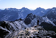
The Torridon Hills exhibit some of the most dramatic mountain scenery in the British Isles
British Isles
The British Isles are a group of islands off the northwest coast of continental Europe that include the islands of Great Britain and Ireland and over six thousand smaller isles. There are two sovereign states located on the islands: the United Kingdom of Great Britain and Northern Ireland and...
, surpassed in grandeur probably only by the Cuillins of Skye
Skye
Skye or the Isle of Skye is the largest and most northerly island in the Inner Hebrides of Scotland. The island's peninsulas radiate out from a mountainous centre dominated by the Cuillin hills...
. The black Cuillins are composed of volcanic gabbro
Gabbro
Gabbro refers to a large group of dark, coarse-grained, intrusive mafic igneous rocks chemically equivalent to basalt. The rocks are plutonic, formed when molten magma is trapped beneath the Earth's surface and cools into a crystalline mass....
, and probably represent the remains of a caldera
Caldera
A caldera is a cauldron-like volcanic feature usually formed by the collapse of land following a volcanic eruption, such as the one at Yellowstone National Park in the US. They are sometimes confused with volcanic craters...
or collapsed volcano. Accessible peaks include Sgurr Alasdair
Sgurr Alasdair
Sgurr Alasdair is the highest peak of the Black Cuillin, and the highest peak on the Isle of Skye. Like the rest of the range it is composed of gabbro, a rock with excellent grip for mountaineering.-Ascent:...
in the west and Sgurr nan Gillean
Sgurr nan Gillean
Sgurr nan Gillean is a mountain in the northern section of the Cuillin range on the Isle of Skye in Scotland. With a height of 964 m it is one of eleven Munros on the Cuillin ridge....
in the east. The red Cuillin to the south is composed of granite
Granite
Granite is a common and widely occurring type of intrusive, felsic, igneous rock. Granite usually has a medium- to coarse-grained texture. Occasionally some individual crystals are larger than the groundmass, in which case the texture is known as porphyritic. A granitic rock with a porphyritic...
.
Parliamentary constituency
The name Ross and Cromarty was first used for the Ross and Cromarty county constituencyRoss and Cromarty (UK Parliament constituency)
Ross and Cromarty was a county constituency of the House of Commons of the Parliament of the United Kingdom from 1832 to 1983. The constituency elected one Member of Parliament using the first-past-the-post voting system....
of the Parliament of the United Kingdom
Parliament of the United Kingdom
The Parliament of the United Kingdom of Great Britain and Northern Ireland is the supreme legislative body in the United Kingdom, British Crown dependencies and British overseas territories, located in London...
from 1832 to 1983. As created in 1832, the constituency merged two former county constituencies: the Ross-shire constituency
Ross-shire (UK Parliament constituency)
Ross-shire was a county constituency of the House of Commons of the Parliament of Great Britain from 1708 to 1801 and of the Parliament of the United Kingdom from 1801 to 1832...
and the Cromartyshire constituency, and it elected a Member of Parliament
Member of Parliament
A Member of Parliament is a representative of the voters to a :parliament. In many countries with bicameral parliaments, the term applies specifically to members of the lower house, as upper houses often have a different title, such as senate, and thus also have different titles for its members,...
to represent the counties of Ross-shire
Ross-shire
Ross-shire is an area in the Highland Council Area in Scotland. The name is now used as a geographic or cultural term, equivalent to Ross. Until 1889 the term denoted a county of Scotland, also known as the County of Ross...
and Cromartyshire
Cromartyshire
Cromartyshire was a county in the Highlands of Scotland, consisting of a main portion between Sutherland and Ross-shire and a series of exclaves within Ross-shire. Ross-shire and Cromartyshire were combined as the single county of Ross and Cromarty by the Local Government Act 1889, and this...
, minus their parliamentary burghs, Dingwall
Dingwall
Dingwall is a town and former royal burgh in the Highland council area of Scotland. It has a population of 5,026. It was formerly an east-coast harbor but now lies inland. Dingwall Castle was once the biggest castle north of Stirling. On the town's present-day outskirts lies Tulloch Castle, parts...
, Tain
Tain
Tain is a royal burgh and post town in the committee area of Ross and Cromarty, in the Highland area of Scotland.-Etymology:...
and Fortrose
Fortrose
Fortrose is a burgh in the Scottish Highlands, located on the Moray Firth, approximately ten kilometres north east of Inverness. The town is known for its ruined 13th century cathedral, and as the home of the Brahan Seer. In the Middle Ages it was the seat of the bishopric of Ross...
, which were represented as components of the Wick burghs constituency and the Inverness burghs constituency.
Constituency boundaries were altered in 1918, by the Representation of the People Act 1918
Representation of the People Act 1918
The Representation of the People Act 1918 was an Act of Parliament passed to reform the electoral system in the United Kingdom. It is sometimes known as the Fourth Reform Act...
, and the Ross and Cromarty constituency acquired the boundaries of the county of Ross and Cromarty, including the former parliamentary burghs, but minus Stornoway
Stornoway
Stornoway is a burgh on the Isle of Lewis, in the Outer Hebrides of Scotland.The town's population is around 9,000, making it the largest settlement in the Western Isles and the third largest town in the Scottish Highlands after Inverness and Fort William...
and Lewis
Lewis
Lewis is the northern part of Lewis and Harris, the largest island of the Western Isles or Outer Hebrides of Scotland. The total area of Lewis is ....
, which became a new constituency, the Western Isles constituency.
In 1983, the Ross, Cromarty and Skye constituency
Ross, Cromarty and Skye (UK Parliament constituency)
Ross, Cromarty and Skye was a constituency of the House of Commons of the Parliament of the United Kingdom from 1983 to 1997. The constituency elected one Member of Parliament by the first-past-the-post system of election....
was created to represent the then Ross and Cromarty district and Skye and Lochalsh
Skye and Lochalsh
Skye and Lochalsh is one of eight former local government districts of the two-tier Highland region of Scotland. The main offices of the Skye and Lochalsh district council were in Portree, on the Isle of Skye.-History:...
district. The Kincardine
Kincardine, Highland
Kincardine is a small hamlet on the west end of the south shore of the Dornoch Firth in the Scottish Highlands and is in the Scottish council area of Highland.The village of Ardgay is less than 1 mile north west of Kincardine along the A836 coast road....
area joined the Caithness and Sutherland constituency
Caithness and Sutherland (UK Parliament constituency)
Caithness and Sutherland was a county constituency of the House of Commons of the Parliament of the United Kingdom from 1918 to 1997. It elected one Member of Parliament by the first past the post system of election....
.
County
The local government county of Ross and Cromarty was created in 1890 under the Local Government (Scotland) Act 1889Local Government (Scotland) Act 1889
The Local Government Act 1889 is an Act of the Parliament of the United Kingdom which was passed on 26 August 1889. The main effect of the Act was to establish elected county councils in Scotland...
, with boundaries similar to, but not exactly the same as, the boundaries of the constituency. The county continued with largely unchanged boundaries until its abolition in 1975.
When the county was abolished in 1975, the mainland part became part of the new Highland Region, and Lewis became part of the Western Isles islands area.
District
In 1975 the mainland part of the former county was effectively divided between three districts of the Highland region. Most of the former county became the new district of Ross and Cromarty. The Lochalsh area joined the Skye and LochalshSkye and Lochalsh
Skye and Lochalsh is one of eight former local government districts of the two-tier Highland region of Scotland. The main offices of the Skye and Lochalsh district council were in Portree, on the Isle of Skye.-History:...
district and the Kincardine
Kincardine, Highland
Kincardine is a small hamlet on the west end of the south shore of the Dornoch Firth in the Scottish Highlands and is in the Scottish council area of Highland.The village of Ardgay is less than 1 mile north west of Kincardine along the A836 coast road....
area joined the Sutherland
Sutherland
Sutherland is a registration county, lieutenancy area and historic administrative county of Scotland. It is now within the Highland local government area. In Gaelic the area is referred to according to its traditional areas: Dùthaich 'IcAoidh , Asainte , and Cataibh...
district. The district was abolished in 1996.
Since 1996
The wards in the former district of Ross and Cromarty formed the management area of Ross and Cromarty from 1996 to 1999, and again from 1999 to 2007. The name was not used for a management area after 2007.Registration county
The registration county of Ross and Cromarty, used for land registry purposes, covers the area of the former county of Ross and Cromarty, including Lewis.Lieutenancy area
Lieutenancy areas are subdivisions used for the ceremonial lords lieutenantLord Lieutenant
The title Lord Lieutenant is given to the British monarch's personal representatives in the United Kingdom, usually in a county or similar circumscription, with varying tasks throughout history. Usually a retired local notable, senior military officer, peer or business person is given the post...
, the monarch's representatives. The Ross and Cromarty lieutenancy area combines the areas of two former districts of the Highland region: Ross and Cromarty, and Skye and Lochalsh. The area therefore includes the mainland part of the registration county and former administrative county of Ross and Cromarty, excluding Kincardine, with the addition of the Isle of Skye, which is in the registration county (and former administrative county) of Inverness-shire
Inverness-shire
The County of Inverness or Inverness-shire was a general purpose county of Scotland, with the burgh of Inverness as the county town, until 1975, when, under the Local Government Act 1973, the county area was divided between the two-tier Highland region and the unitary Western Isles. The Highland...
.
Further reading
- D. Alston, Ross and Cromarty : a historical guide (Edinburgh : Birlinn, 1999 ISBN 1-874744-48-3), which, however, restricts itself to coverage of the mainland county;
- R. Bain, History of the Ancient Province of Ross (Dingwall, 1899);
- J. H. Dixon, Gairloch (Edinburgh, 1888);
- F. N. Reid, The Earls of Ross (Edinburgh, 1894);
- W. C. Mackenzie, History of the Outer Hebrides (Paisley, 1904).