
River Erme
Encyclopedia
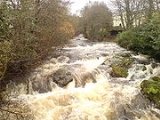
The Erme is a river in south Devon
, England
. From its source on Dartmoor
it flows in a generally southerly direction past some of the best-preserved archaeological remains on the moor. It leaves the moor at the town of Ivybridge
and continues southward, passing the settlements of Ermington
, Modbury
and Holbeton
. Near Holbeton it becomes a ria
and empties into the English Channel
in Bigbury Bay, between the rivers Yealm
and Avon
.
, an imperfect list of place-names that was compiled in the early 8th century from late Roman sources, lists amongst many others, over twenty names that probably refer to places in south-west England. Most of these have not been positively identified, but the name Aramis/Aranus/Armis was suggested to be the River Erme by Rivet and Smith in The Place-names of Roman Britain (1979).
The first certain documentary reference to the river is as Irym in the cartulary of Buckfast Abbey
, dated 1240. Other early recorded forms are Hyrm, Irm, Erm and, in the mid 16th century, Arme. The derivation of the name remains unknown. Ekwall
's suggestion that it is a back-formation
from Ermington is now thought to be unlikely. Tristram Risdon
, in his 1811 Survey of Devon gives an alternate name for the River Erme as the River Arme. He also refers to the mouth of the River Erme as Armouth. In Donn's map of Devon
published in 1765, the village of Mothecombe at the mouth of the river, is referred to as Muddicomb.
on the Abbot's Way less than a mile to the south of the source of the River Plym
. Between these two sources lies Duck's Pool
, where there is a plaque and letterbox in memory of the Dartmoor author William Crossing
. There are extensive early tin mining
workings nearby known as Erme Pits, which are in places over 15 metres deep.
For the first mile or so the river flows south-eastwards. It is joined on the north bank by Wollake, which is the lower part of the Blacklane Brook that rises on the southern flanks of Fox Tor
a mile and a half to the north, between Crane Hill and Naker's Hill. The short streams, Dry Lake and Red Lake also join on this side, the latter rising near the disused clay works at Redlake
. The confluence
of Red Lake, and the source of the Erme are two of the thirty-three places that delineate the ancient boundary of the Forest of Dartmoor
. On this stretch, a short stream flowing down Hortonsford Bottom from Langcombe Hill also joins the river from the south.
Between Stingers Hill and Redlake the river turns southward into an area known as The Meadow, where it is crossed by the Upper Erme stone row, the longest on Dartmoor at 3320 m (10,892.4 ft). For the next mile or more downstream from here there are extensive archaeological remains on the river's banks, most notably Erme Pound (the highest and largest Bronze Age
enclosure in the area), Downing's House (a well-preserved "tinner's cache" or "beehive hut" with much of its roof preserved), and a number of tinner's huts and blowing house
s.
As the river reaches the edge of the high moor, it flows through the gorge it has cut between Stalldown Barrow on the west and Piles Hill to the east. Here, on the eastern bank, lies Piles Copse which is one of the few areas of ancient woodland on Dartmoor and a Site of Special Scientific Interest
.
Although the moorland valley of the Erme today appears to be natural and unspoiled, the entire valley floor from its source down to Piles Copse is artificial, being created by the extensive tin-streaming operations that took place between the 4th and 14th centuries. Supporting evidence for this was provided by a study published in 2004 which showed that phases of aggradation
occurred lower down the valley between the 4th century and the 7th century, and in the 13th century.
Leaving the open moor, the river passes into enclosed land and under its first road bridge at the hamlet of Harford
. From Harford down to the boundary of the national park
, which here follows the main railway line between Plymouth
and Exeter
, much of the river's course is in woodland and is a popular site for kayaking and canoeing, especially in Long Timber Woods.
where it formed the source of the town's prosperity by powering a grist mill, a paper mill
and a fulling and tucking
mill. In 1813 the only bridge over the river in the village (as it was then) was the inspiration for J. M. W. Turner
's painting The Ivy Bridge.
Immediately south of Ivybridge, the river passes beneath the Devon Expressway – the main road link between Exeter and Plymouth – and then continues to flow southerly through countryside. On its western bank is the village of Ermington
with its famous crooked church spire and the Grade I listed Flete House
; and about a mile to the east, the small town of Modbury
. The A379 road
between Modbury and Yealmpton
crosses the river at Sequer's Bridge, shortly below which the river flows over a weir
and becomes tidal.
Surrounding this stretch of the river there are several apple orchards, remnants of the many that were once here. Unlike most of the South Hams
where the field boundaries consist of Devon hedge banks, hereabouts the boundaries are walls constructed from rounded river boulders, more like the dry stone walls found on Dartmoor.
the Erme becomes a ria
with extensive areas of salt marsh
and mud that are uncovered at low tide. The geology of the area is mostly slate
from the Devonian
period. The river enters the English Channel
near the villages of Kingston
to the east and Mothecombe and Holbeton
to the west and at the mouth of the estuary lie the beaches of Wonwell and Mothecombe. The estuary is surrounded by the 5,000 acre Flete Estate.
on the north side of the West Mary Reef. These date from between 500 BC and 600 AD. Tin mining
was in existence on Dartmoor
from an early date. Dartmoor tin-mining
would have been a major part of the South Devon economy throughout its history.
There is an Iron Age hill fort
at Holbury
near Holbeton
overlooking the estuary from the west and evidence of a very early 11th Century fort and settlement just a little way inland at Oldaport. In the 1950s and again in the 1990s a variety of fragments of "Dark Ages" and Roman pots were discovered on Mothecombe beach
There are four ruined lime kilns in the estuary; all are in an advanced state of disrepair. Limestone came by sea from Plymouth
quarries. Coal arrived on the beach from South Wales and was unloaded to horse drawn carts. Some was stored in a shed at the top of the Mothecombe slip, but some was loaded into a small barge to move further up the estuary as far as Efford.
From Clyng Corn Mill (now a private house to Orcheton Quay) there used to be a canal which has long since silted up and is now just a small stream. This canal brought goods to and from Modbury and beyond. "Runaway Lane" was the main link between Orcheton Quay and Modbury. The 1809 Ordnance Survey map shows the canal very clearly.
There was a fishing community on Wonwell beach for many years but the houses are now in ruins and overgrown. Professional fishermen worked the beach until the 1960s. The main catch was lobster
and crab
. These were boiled on the beach and carried to the village of Kingston on donkeys. The withies which were used to make the pots and panniers were grown in willow plats (areas of pollarded willow) in the area.
Many ships have been lost in the area over the centuries. The Salcombe Cannon Wreck
of the 1630s is a notable site. A large cast iron Swedish gun dating to 1690–1720 has been found in the estuary. On 15 December 1793, HMS Pygmy went aground on the jagged East Mary rocks, which together with the West Mary Rocks form a mostly submerged bar to the estuary. At the court martial, the vessel's pilot stated that he believed that he was entering Plymouth Sound
, some 14 miles west.
, supplanted by the coastguards: on the Mothecombe side are the original Coastguard Cottages - just above Coastguard Beach. "Customs Ports" were first set out in 1558 as administrative areas. In 1786 when every part of the coastline came under the jurisdiction of the local "Customs Port", the Plymouth jurisdiction extended as far east as Challaborough and therefore covered the estuary. Records show that the Coastguard Station existed at Mothecombe in 1822 with 5 Boatmen and an Officer. In 1870 the Chief Officer of Coastal Guard at Mothecombe was Robert S Matson. By 1881 the River Erme was included in the Dartmouth
"Customs Port". Coastguards were also based in the village of Kingston. The next station going east was at Charlaborough (Ringmore) - now called Challaborough.
in 1945 and her wreck is just outside the estuary.
In 1940 a detachment of Indian troops were stationed at Woodleigh and there is a remembrance of these troops and their mules delivering barbed wire to Mothecombe for the coastal defences.
There was a memory of a dog setting off mines on the estuary recorded in a publication produced by the Kingston History Society. A platoon of the 5th Buffs Regiment was stationed on Wonwell Beach; some in a Nissen Hut and some in one of the old cottages. One soldier was stationed at the phone box in Kingston to take messages to the beach. There was a mine field at the high water mark which was fenced on the landward side. Mothecombe Beach had a similar minefield. One of the mines on Wonwell was set off by a missing dog after the platoon at Wonwell had been withdrawn (as the beach was covered from Mothecombe). Others became unstable and also exploded.
The 1919 and 1947 Ordnance Survey maps show a "rifle range" stretching up the estuary from Owen's Point to Pamflete—this may have been related to war time activity.
TV series on the Wonwell slip, Wonwell Beach and Mothecombe Beach. International Velvet
(1978) has an opening scene across the sands. In 1985 Scobbiscombe Farm, which is above and just to the east of the estuary, was used as a location for the film Revolution
which concerned the American War of Independence. The cast included Al Pacino
, Donald Sutherland
and a whole host of cut out British Red Coats
, one of whom found a new home in a local greenhouse for a while. Sense and Sensibility (1995) was shot at various locations on the estuary including Efford House (country home of the "Dashwoods"), Mothecombe House and Mothecombe Beach. Rebecca (1996) was filmed at Mothecombe.
, and an Erme Estuary Management Plan has been produced. The South West Coast Path
crosses between the slipways on the Wonwell (eastern) and Mothecombe (western) sides of the estuary
, but crossing is only possible at low tide - and even then walkers are very likely to get their knees wet. The alternative route by road is some 9 miles around the estuary. The 1947 Ordnance Survey
map show this as a vehicular ford between the slipways. There is another ford marked on the 1947 map between Saltercrease and Efford, but this is now said to be too deep to cross.
, oystercatcher
s and shelduck
are all regular visitors and kingfishers are often seen above Holbeton. Weaverfish bury themselves in the gravel in the low water.
.
Coastguards Beach and Wonwell Beach are open every day. Coastguards Beach also has a pillbox although it is now almost covered by undergrowth, and the remains of yet another lie a little south of Coastguards beach, but this has been damaged by the sea.
Devon
Devon is a large county in southwestern England. The county is sometimes referred to as Devonshire, although the term is rarely used inside the county itself as the county has never been officially "shired", it often indicates a traditional or historical context.The county shares borders with...
, England
England
England is a country that is part of the United Kingdom. It shares land borders with Scotland to the north and Wales to the west; the Irish Sea is to the north west, the Celtic Sea to the south west, with the North Sea to the east and the English Channel to the south separating it from continental...
. From its source on Dartmoor
Dartmoor
Dartmoor is an area of moorland in south Devon, England. Protected by National Park status, it covers .The granite upland dates from the Carboniferous period of geological history. The moorland is capped with many exposed granite hilltops known as tors, providing habitats for Dartmoor wildlife. The...
it flows in a generally southerly direction past some of the best-preserved archaeological remains on the moor. It leaves the moor at the town of Ivybridge
Ivybridge
Ivybridge is a small town and civil parish in the South Hams, in Devon, England. It lies about east of Plymouth. It is at the southern extremity of Dartmoor, a National Park of England and Wales and lies along the A38 "Devon Expressway" road...
and continues southward, passing the settlements of Ermington
Ermington, Devon
Ermington is a village and civil parish located approximately south of the town of Ivybridge in the county of Devon, England. The village is in the South Hams district and is twinned with the commune of Clécy, in Normandy, France. It is known well for its crooked church spire, which a pub has been...
, Modbury
Modbury
Modbury is a town and parish in the South Hams region of the English county of Devon. It is situated on the A379 road, which links it to Plymouth and Kingsbridge...
and Holbeton
Holbeton
Holbeton is a village located 9 miles south east of Plymouth in Devon, UK. Historically it formed part of Ermington Hundred. To the east of the village is an Iron age enclosure or Hill fort known as Holbury...
. Near Holbeton it becomes a ria
Ria
A ria is a coastal inlet formed by the partial submergence of an unglaciated river valley. It is a drowned river valley that remains open to the sea. Typically, rias have a dendritic, treelike outline although they can be straight and without significant branches. This pattern is inherited from the...
and empties into the English Channel
English Channel
The English Channel , often referred to simply as the Channel, is an arm of the Atlantic Ocean that separates southern England from northern France, and joins the North Sea to the Atlantic. It is about long and varies in width from at its widest to in the Strait of Dover...
in Bigbury Bay, between the rivers Yealm
River Yealm
Yealm is a river in Dartmoor in Devon in south-west England. It rises 1,411 feet above sea level on the Stall Moor mires of south Dartmoor and makes a 12 mile journey to the sea, passing through Cornwood, Lee Mill and Yealmpton, before reaching the estuary mouth just below Newton Ferrers and Noss...
and Avon
River Avon, Devon
The River Avon, also known as the River Aune, is a river in the county of Devon in the south of England. It rises in the southern half of Dartmoor National Park in an area of bog to the west of Ryder's Hill. Close to where the river leaves Dartmoor a dam was built in 1957 to form the Avon reservoir...
.
Toponymy
The Ravenna CosmographyRavenna Cosmography
The Ravenna Cosmography was compiled by an anonymous cleric in Ravenna around AD 700. It consists of a list of place-names covering the world from India to Ireland. Textual evidence indicates that the author frequently used maps as his source....
, an imperfect list of place-names that was compiled in the early 8th century from late Roman sources, lists amongst many others, over twenty names that probably refer to places in south-west England. Most of these have not been positively identified, but the name Aramis/Aranus/Armis was suggested to be the River Erme by Rivet and Smith in The Place-names of Roman Britain (1979).
The first certain documentary reference to the river is as Irym in the cartulary of Buckfast Abbey
Buckfast Abbey
Buckfast Abbey forms part of an active Benedictine monastery at Buckfast, near Buckfastleigh, Devon, England. Dedicated to Saint Mary, it was founded in 1018 and run by the Cistercian order from 1147 until it was destroyed under the Dissolution of the Monasteries...
, dated 1240. Other early recorded forms are Hyrm, Irm, Erm and, in the mid 16th century, Arme. The derivation of the name remains unknown. Ekwall
Eilert Ekwall
Bror Oscar Eilert Ekwall , known as Eilert Ekwall, was Professor of English at Lund University, Sweden, from 1909 to 1942, and one of the outstanding scholars of the English language of the first half of the 20th century...
's suggestion that it is a back-formation
Back-formation
In etymology, back-formation is the process of creating a new lexeme, usually by removing actual or supposed affixes. The resulting neologism is called a back-formation, a term coined by James Murray in 1889...
from Ermington is now thought to be unlikely. Tristram Risdon
Tristram Risdon
Tristram Risdon was an English antiquary and topographer, and the author of Survey of the County of Devon. He was able to devote most of his life to writing this work. After he completed it in about 1632 it circulated around interested people in several manuscript copies for almost 80 years before...
, in his 1811 Survey of Devon gives an alternate name for the River Erme as the River Arme. He also refers to the mouth of the River Erme as Armouth. In Donn's map of Devon
Benjamin Donn
-Life:Donn was born at Bideford, Devon, where his father and brother Abraham kept a school. Until 1768 he was a ‘teacher of the mathematics and natural philosophy on the Newtonian principles’ in his native town....
published in 1765, the village of Mothecombe at the mouth of the river, is referred to as Muddicomb.
On Dartmoor
The River Erme rises near the centre of southern DartmoorDartmoor
Dartmoor is an area of moorland in south Devon, England. Protected by National Park status, it covers .The granite upland dates from the Carboniferous period of geological history. The moorland is capped with many exposed granite hilltops known as tors, providing habitats for Dartmoor wildlife. The...
on the Abbot's Way less than a mile to the south of the source of the River Plym
River Plym
The River Plym is a river in Devon, England. Its source is some 450m above sea level on Dartmoor, in an upland marshy area called Plym Head. From the upper reaches which contain antiquities and mining remains the river flows roughly southwest and enters the sea near to the city of Plymouth, where...
. Between these two sources lies Duck's Pool
Duck's Pool, Dartmoor
Duck's Pool is a small depression set in a remote location in the southern half of Dartmoor, Devon, England at . It lies between the sources of the River Plym and the River Erme....
, where there is a plaque and letterbox in memory of the Dartmoor author William Crossing
William Crossing
William Crossing was a writer and documenter of Dartmoor and Dartmoor life. He lived successively at South Brent, Brentor and at Mary Tavy but died at Plymouth.-Early life:...
. There are extensive early tin mining
Dartmoor tin-mining
The Dartmoor tin mining industry is thought to have originated in pre-Roman times, and continued right through to the 20th century. From the 12th century onwards tin mining was regulated by a Stannary Parliament which had its own laws....
workings nearby known as Erme Pits, which are in places over 15 metres deep.
For the first mile or so the river flows south-eastwards. It is joined on the north bank by Wollake, which is the lower part of the Blacklane Brook that rises on the southern flanks of Fox Tor
Fox Tor
Fox Tor is a relatively minor tor on Dartmoor in the United Kingdom. It is probably best known for the swampy land that lies beneath it, Fox Tor Mires. This is said to have been the inspiration for the fictional Grimpen Mire in the novel The Hound of the Baskervilles by Sir Arthur Conan Doyle...
a mile and a half to the north, between Crane Hill and Naker's Hill. The short streams, Dry Lake and Red Lake also join on this side, the latter rising near the disused clay works at Redlake
Redlake Tramway
The Redlake Tramway was a railway built to carry supplies and workers between Bittaford and the clay workings at Redlake, near the centre of the southern part of Dartmoor, Devon, England. It was built in 1911 to a gauge of , and ran for a circuitous ....
. The confluence
Confluence
Confluence, in geography, describes the meeting of two or more bodies of water.Confluence may also refer to:* Confluence , a property of term rewriting systems...
of Red Lake, and the source of the Erme are two of the thirty-three places that delineate the ancient boundary of the Forest of Dartmoor
Forest of Dartmoor
The Forest of Dartmoor is an ancient royal forest covering part of Dartmoor, Devon, England.A royal forest was an area reserved by the king for hunting, and William the Conqueror introduced the concept of forest law in England in the 11th century...
. On this stretch, a short stream flowing down Hortonsford Bottom from Langcombe Hill also joins the river from the south.
Between Stingers Hill and Redlake the river turns southward into an area known as The Meadow, where it is crossed by the Upper Erme stone row, the longest on Dartmoor at 3320 m (10,892.4 ft). For the next mile or more downstream from here there are extensive archaeological remains on the river's banks, most notably Erme Pound (the highest and largest Bronze Age
Bronze Age Britain
Bronze Age Britain refers to the period of British history that spanned from c. 2,500 until c. 800 BC. Lasting for approximately 1700 years, it was preceded by the era of Neolithic Britain and was in turn followed by the era of Iron Age Britain...
enclosure in the area), Downing's House (a well-preserved "tinner's cache" or "beehive hut" with much of its roof preserved), and a number of tinner's huts and blowing house
Blowing House
A blowing house or blowing mill was a building used for smelting tin in Cornwall and on Dartmoor in Devon, in South West England. Blowing houses contained a furnace and a pair of bellows that were powered by an adjacent water wheel, and they were in use from the early 14th century until they were...
s.
As the river reaches the edge of the high moor, it flows through the gorge it has cut between Stalldown Barrow on the west and Piles Hill to the east. Here, on the eastern bank, lies Piles Copse which is one of the few areas of ancient woodland on Dartmoor and a Site of Special Scientific Interest
Site of Special Scientific Interest
A Site of Special Scientific Interest is a conservation designation denoting a protected area in the United Kingdom. SSSIs are the basic building block of site-based nature conservation legislation and most other legal nature/geological conservation designations in Great Britain are based upon...
.
Although the moorland valley of the Erme today appears to be natural and unspoiled, the entire valley floor from its source down to Piles Copse is artificial, being created by the extensive tin-streaming operations that took place between the 4th and 14th centuries. Supporting evidence for this was provided by a study published in 2004 which showed that phases of aggradation
Aggradation
Aggradation is the term used in geology for the increase in land elevation due to the deposition of sediment. Aggradation occurs in areas in which the supply of sediment is greater than the amount of material that the system is able to transport...
occurred lower down the valley between the 4th century and the 7th century, and in the 13th century.
Leaving the open moor, the river passes into enclosed land and under its first road bridge at the hamlet of Harford
Harford, Devon
Harford is a hamlet and civil parish located approximately north of the town of Ivybridge in the county of Devon, England. The parish lies in the local government district of the South Hams, which is a localised, second-tier governmental division of the non-metropolitan county of Devon,...
. From Harford down to the boundary of the national park
National parks of England and Wales
The national parks of England and Wales are areas of relatively undeveloped and scenic landscape that are designated under the National Parks and Access to the Countryside Act 1949...
, which here follows the main railway line between Plymouth
Plymouth
Plymouth is a city and unitary authority area on the coast of Devon, England, about south-west of London. It is built between the mouths of the rivers Plym to the east and Tamar to the west, where they join Plymouth Sound...
and Exeter
Exeter
Exeter is a historic city in Devon, England. It lies within the ceremonial county of Devon, of which it is the county town as well as the home of Devon County Council. Currently the administrative area has the status of a non-metropolitan district, and is therefore under the administration of the...
, much of the river's course is in woodland and is a popular site for kayaking and canoeing, especially in Long Timber Woods.
Ivybridge to Holbeton
After leaving the national park, the river continues southward, passing through the centre of the town of IvybridgeIvybridge
Ivybridge is a small town and civil parish in the South Hams, in Devon, England. It lies about east of Plymouth. It is at the southern extremity of Dartmoor, a National Park of England and Wales and lies along the A38 "Devon Expressway" road...
where it formed the source of the town's prosperity by powering a grist mill, a paper mill
Paper mill
A paper mill is a factory devoted to making paper from vegetable fibres such as wood pulp, old rags and other ingredients using a Fourdrinier machine or other type of paper machine.- History :...
and a fulling and tucking
Fulling
Fulling or tucking or walking is a step in woolen clothmaking which involves the cleansing of cloth to eliminate oils, dirt, and other impurities, and making it thicker. The worker who does the job is a fuller, tucker, or walker...
mill. In 1813 the only bridge over the river in the village (as it was then) was the inspiration for J. M. W. Turner
J. M. W. Turner
Joseph Mallord William Turner RA was an English Romantic landscape painter, watercolourist and printmaker. Turner was considered a controversial figure in his day, but is now regarded as the artist who elevated landscape painting to an eminence rivalling history painting...
's painting The Ivy Bridge.
Immediately south of Ivybridge, the river passes beneath the Devon Expressway – the main road link between Exeter and Plymouth – and then continues to flow southerly through countryside. On its western bank is the village of Ermington
Ermington, Devon
Ermington is a village and civil parish located approximately south of the town of Ivybridge in the county of Devon, England. The village is in the South Hams district and is twinned with the commune of Clécy, in Normandy, France. It is known well for its crooked church spire, which a pub has been...
with its famous crooked church spire and the Grade I listed Flete House
Flete House
Flete House is a Grade I listed country house at Holbeton, in the South Hams district of Devon, England.Flete was a Saxon estate, the manor being held by the Damarell family from the reign of William I until the time of Edward III....
; and about a mile to the east, the small town of Modbury
Modbury
Modbury is a town and parish in the South Hams region of the English county of Devon. It is situated on the A379 road, which links it to Plymouth and Kingsbridge...
. The A379 road
A379 road
The A379 is a road in the English county of Devon. It links points on the edges of that county's two principal cities, Exeter and Plymouth, by an indirect and largely coastal route....
between Modbury and Yealmpton
Yealmpton
Yealmpton is a village in the English county of Devon. It is located on the A379 Plymouth to Kingsbridge road and is about from Plymouth. It derives its name from the River Yealm that flows through the village. Yealmpton is home to a 400 year-old stone cottage, where it is said, a version of the...
crosses the river at Sequer's Bridge, shortly below which the river flows over a weir
Weir
A weir is a small overflow dam used to alter the flow characteristics of a river or stream. In most cases weirs take the form of a barrier across the river that causes water to pool behind the structure , but allows water to flow over the top...
and becomes tidal.
Surrounding this stretch of the river there are several apple orchards, remnants of the many that were once here. Unlike most of the South Hams
South Hams
South Hams is a local government district on the south coast of Devon, England with its headquarters in the town of Totnes. It contains the towns of Dartmouth, Kingsbridge, Ivybridge, Salcombe — the largest of which is Ivybridge with a population of 16,056....
where the field boundaries consist of Devon hedge banks, hereabouts the boundaries are walls constructed from rounded river boulders, more like the dry stone walls found on Dartmoor.
The estuary
As it passes to the east of the village of HolbetonHolbeton
Holbeton is a village located 9 miles south east of Plymouth in Devon, UK. Historically it formed part of Ermington Hundred. To the east of the village is an Iron age enclosure or Hill fort known as Holbury...
the Erme becomes a ria
Ria
A ria is a coastal inlet formed by the partial submergence of an unglaciated river valley. It is a drowned river valley that remains open to the sea. Typically, rias have a dendritic, treelike outline although they can be straight and without significant branches. This pattern is inherited from the...
with extensive areas of salt marsh
Salt marsh
A salt marsh is an environment in the upper coastal intertidal zone between land and salt water or brackish water, it is dominated by dense stands of halophytic plants such as herbs, grasses, or low shrubs. These plants are terrestrial in origin and are essential to the stability of the salt marsh...
and mud that are uncovered at low tide. The geology of the area is mostly slate
Slate
Slate is a fine-grained, foliated, homogeneous metamorphic rock derived from an original shale-type sedimentary rock composed of clay or volcanic ash through low-grade regional metamorphism. The result is a foliated rock in which the foliation may not correspond to the original sedimentary layering...
from the Devonian
Devonian
The Devonian is a geologic period and system of the Paleozoic Era spanning from the end of the Silurian Period, about 416.0 ± 2.8 Mya , to the beginning of the Carboniferous Period, about 359.2 ± 2.5 Mya...
period. The river enters the English Channel
English Channel
The English Channel , often referred to simply as the Channel, is an arm of the Atlantic Ocean that separates southern England from northern France, and joins the North Sea to the Atlantic. It is about long and varies in width from at its widest to in the Strait of Dover...
near the villages of Kingston
Kingston, Devon
Kingston is civil parish and small scattered village in the South Hams, Devon, England. It is three miles south west of Modbury, and about a mile from the mouth of the River Erme at Wonwell. See the entry for Erme Mouth. In 2001 the population of the parish was 399. It has a small village hall -...
to the east and Mothecombe and Holbeton
Holbeton
Holbeton is a village located 9 miles south east of Plymouth in Devon, UK. Historically it formed part of Ermington Hundred. To the east of the village is an Iron age enclosure or Hill fort known as Holbury...
to the west and at the mouth of the estuary lie the beaches of Wonwell and Mothecombe. The estuary is surrounded by the 5,000 acre Flete Estate.
History
In 1991 and 1992 some 42 tin ingots were found in the mouth of the estuaryon the north side of the West Mary Reef. These date from between 500 BC and 600 AD. Tin mining
Tin mining in Britain
Tin mining in Britain took place from prehistoric times until the 20th century. Mention of tin mining in Britain was made by many Classical writers. As South-West Britain was one of the few parts of England to escape glaciation, tin ore was readily available on the surface...
was in existence on Dartmoor
Dartmoor
Dartmoor is an area of moorland in south Devon, England. Protected by National Park status, it covers .The granite upland dates from the Carboniferous period of geological history. The moorland is capped with many exposed granite hilltops known as tors, providing habitats for Dartmoor wildlife. The...
from an early date. Dartmoor tin-mining
Dartmoor tin-mining
The Dartmoor tin mining industry is thought to have originated in pre-Roman times, and continued right through to the 20th century. From the 12th century onwards tin mining was regulated by a Stannary Parliament which had its own laws....
would have been a major part of the South Devon economy throughout its history.
There is an Iron Age hill fort
Hill fort
A hill fort is a type of earthworks used as a fortified refuge or defended settlement, located to exploit a rise in elevation for defensive advantage. They are typically European and of the Bronze and Iron Ages. Some were used in the post-Roman period...
at Holbury
Holbury, Holbeton
Holbury is an Iron Age hill fort situated close to Holbeton in Devon, England. The fort is situated on a hilltop east of the Village approximately 95 metres above sea level overlooking the Erme Estuary....
near Holbeton
Holbeton
Holbeton is a village located 9 miles south east of Plymouth in Devon, UK. Historically it formed part of Ermington Hundred. To the east of the village is an Iron age enclosure or Hill fort known as Holbury...
overlooking the estuary from the west and evidence of a very early 11th Century fort and settlement just a little way inland at Oldaport. In the 1950s and again in the 1990s a variety of fragments of "Dark Ages" and Roman pots were discovered on Mothecombe beach
There are four ruined lime kilns in the estuary; all are in an advanced state of disrepair. Limestone came by sea from Plymouth
Plymouth
Plymouth is a city and unitary authority area on the coast of Devon, England, about south-west of London. It is built between the mouths of the rivers Plym to the east and Tamar to the west, where they join Plymouth Sound...
quarries. Coal arrived on the beach from South Wales and was unloaded to horse drawn carts. Some was stored in a shed at the top of the Mothecombe slip, but some was loaded into a small barge to move further up the estuary as far as Efford.
From Clyng Corn Mill (now a private house to Orcheton Quay) there used to be a canal which has long since silted up and is now just a small stream. This canal brought goods to and from Modbury and beyond. "Runaway Lane" was the main link between Orcheton Quay and Modbury. The 1809 Ordnance Survey map shows the canal very clearly.
There was a fishing community on Wonwell beach for many years but the houses are now in ruins and overgrown. Professional fishermen worked the beach until the 1960s. The main catch was lobster
Lobster
Clawed lobsters comprise a family of large marine crustaceans. Highly prized as seafood, lobsters are economically important, and are often one of the most profitable commodities in coastal areas they populate.Though several groups of crustaceans are known as lobsters, the clawed lobsters are most...
and crab
Crab
True crabs are decapod crustaceans of the infraorder Brachyura, which typically have a very short projecting "tail" , or where the reduced abdomen is entirely hidden under the thorax...
. These were boiled on the beach and carried to the village of Kingston on donkeys. The withies which were used to make the pots and panniers were grown in willow plats (areas of pollarded willow) in the area.
Many ships have been lost in the area over the centuries. The Salcombe Cannon Wreck
Salcombe Cannon Wreck
The Salcombe Cannon wrecksite is close to two other designated wrecksites in the Erme Estuary which the South West Maritime Archaeological Group was licensed to investigate. In 1992 this group described the Salcombe Cannon site as:...
of the 1630s is a notable site. A large cast iron Swedish gun dating to 1690–1720 has been found in the estuary. On 15 December 1793, HMS Pygmy went aground on the jagged East Mary rocks, which together with the West Mary Rocks form a mostly submerged bar to the estuary. At the court martial, the vessel's pilot stated that he believed that he was entering Plymouth Sound
Plymouth Sound
Plymouth Sound, or locally just The Sound, is a bay at Plymouth in England.Its southwest and southeast corners are Penlee Point in Cornwall and Wembury Point on Devon, a distance of about 3 nautical miles . Its northern limit is Plymouth Hoe giving a north-south distance of nearly 3 nautical miles...
, some 14 miles west.
Smuggling
Smuggling activity took place in the estuary. Initially the coast was patrolled by the Riding Officers of the PreventiveRiding officer
The Riding Officer was an occupation common during the 18th century around the coastlines of Britain. The principal duty of the office was to visit the coast within their predefined riding range, to meet and correspond with the other riding officers either in person or by letter, and to inquire and...
, supplanted by the coastguards: on the Mothecombe side are the original Coastguard Cottages - just above Coastguard Beach. "Customs Ports" were first set out in 1558 as administrative areas. In 1786 when every part of the coastline came under the jurisdiction of the local "Customs Port", the Plymouth jurisdiction extended as far east as Challaborough and therefore covered the estuary. Records show that the Coastguard Station existed at Mothecombe in 1822 with 5 Boatmen and an Officer. In 1870 the Chief Officer of Coastal Guard at Mothecombe was Robert S Matson. By 1881 the River Erme was included in the Dartmouth
Dartmouth, Devon
Dartmouth is a town and civil parish in the English county of Devon. It is a tourist destination set on the banks of the estuary of the River Dart, which is a long narrow tidal ria that runs inland as far as Totnes...
"Customs Port". Coastguards were also based in the village of Kingston. The next station going east was at Charlaborough (Ringmore) - now called Challaborough.
World War II
Persier was hit by a torpedo near to the Eddystone LighthouseEddystone Lighthouse
Eddystone Lighthouse is on the treacherous Eddystone Rocks, south west of Rame Head, United Kingdom. While Rame Head is in Cornwall, the rocks are in Devon and composed of Precambrian Gneiss....
in 1945 and her wreck is just outside the estuary.
In 1940 a detachment of Indian troops were stationed at Woodleigh and there is a remembrance of these troops and their mules delivering barbed wire to Mothecombe for the coastal defences.
There was a memory of a dog setting off mines on the estuary recorded in a publication produced by the Kingston History Society. A platoon of the 5th Buffs Regiment was stationed on Wonwell Beach; some in a Nissen Hut and some in one of the old cottages. One soldier was stationed at the phone box in Kingston to take messages to the beach. There was a mine field at the high water mark which was fenced on the landward side. Mothecombe Beach had a similar minefield. One of the mines on Wonwell was set off by a missing dog after the platoon at Wonwell had been withdrawn (as the beach was covered from Mothecombe). Others became unstable and also exploded.
The 1919 and 1947 Ordnance Survey maps show a "rifle range" stretching up the estuary from Owen's Point to Pamflete—this may have been related to war time activity.
Film locations
Filming took part for some of the HornblowerHornblower (TV series)
Hornblower is the umbrella title of a series of television drama programmes based on C. S. Forester's novels about the fictional character Horatio Hornblower, a Royal Naval officer during the French Revolutionary Wars and the Napoleonic Wars....
TV series on the Wonwell slip, Wonwell Beach and Mothecombe Beach. International Velvet
International Velvet (film)
International Velvet is a 1978 dramatic film. It was a remake of the 1944 classic, National Velvet. The film stars Tatum O'Neal, Christopher Plummer, Anthony Hopkins and Nanette Newman. The film got mixed reviews.-Plot:...
(1978) has an opening scene across the sands. In 1985 Scobbiscombe Farm, which is above and just to the east of the estuary, was used as a location for the film Revolution
Revolution (1985 film)
Revolution is a 1985 film directed by Hugh Hudson, written by Robert Dillon and starring Al Pacino, Helen Porter, Donald Sutherland, Nastassja Kinski, Joan Plowright, Dave King, Annie Lennox, Danny Turner, Steven Berkoff, Graham Greene, and Robbie Coltrane....
which concerned the American War of Independence. The cast included Al Pacino
Al Pacino
Alfredo James "Al" Pacino is an American film and stage actor and director. He is famous for playing mobsters, including Michael Corleone in The Godfather trilogy, Tony Montana in Scarface, Alphonse "Big Boy" Caprice in Dick Tracy and Carlito Brigante in Carlito's Way, though he has also appeared...
, Donald Sutherland
Donald Sutherland
Donald McNichol Sutherland, OC is a Canadian actor with a film career spanning nearly 50 years. Some of Sutherland's more notable movie roles included offbeat warriors in such war movies as The Dirty Dozen, , MASH , and Kelly's Heroes , as well as in such popular films as Klute, Invasion of the...
and a whole host of cut out British Red Coats
Red coat (British army)
Red coat or Redcoat is a historical term used to refer to soldiers of the British Army because of the red uniforms formerly worn by the majority of regiments. From the late 17th century to the early 20th century, the uniform of most British soldiers, , included a madder red coat or coatee...
, one of whom found a new home in a local greenhouse for a while. Sense and Sensibility (1995) was shot at various locations on the estuary including Efford House (country home of the "Dashwoods"), Mothecombe House and Mothecombe Beach. Rebecca (1996) was filmed at Mothecombe.
Today
The estuary is now designated as an Area of Outstanding Natural BeautyArea of Outstanding Natural Beauty
An Area of Outstanding Natural Beauty is an area of countryside considered to have significant landscape value in England, Wales or Northern Ireland, that has been specially designated by the Countryside Agency on behalf of the United Kingdom government; the Countryside Council for Wales on...
, and an Erme Estuary Management Plan has been produced. The South West Coast Path
South West Coast Path
The South West Coast Path is Britain's longest waymarked long-distance footpath and a National Trail. It stretches for , running from Minehead in Somerset, along the coasts of Devon and Cornwall, to Poole Harbour in Dorset. Since it rises and falls with every river mouth, it is also one of the more...
crosses between the slipways on the Wonwell (eastern) and Mothecombe (western) sides of the estuary
Estuary
An estuary is a partly enclosed coastal body of water with one or more rivers or streams flowing into it, and with a free connection to the open sea....
, but crossing is only possible at low tide - and even then walkers are very likely to get their knees wet. The alternative route by road is some 9 miles around the estuary. The 1947 Ordnance Survey
Ordnance Survey
Ordnance Survey , an executive agency and non-ministerial government department of the Government of the United Kingdom, is the national mapping agency for Great Britain, producing maps of Great Britain , and one of the world's largest producers of maps.The name reflects its creation together with...
map show this as a vehicular ford between the slipways. There is another ford marked on the 1947 map between Saltercrease and Efford, but this is now said to be too deep to cross.
Flora and fauna
Egrets migrated to the estuary until the mid to late 1980s and are now year-round residents. CurlewCurlew
The curlews , genus Numenius, are a group of eight species of birds, characterised by long, slender, downcurved bills and mottled brown plumage. They are one of the most ancient lineages of scolopacid waders, together with the godwits which look similar but have straight bills...
, oystercatcher
Oystercatcher
The oystercatchers are a group of waders; they form the family Haematopodidae, which has a single genus, Haematopus. They are found on coasts worldwide apart from the polar regions and some tropical regions of Africa and South East Asia...
s and shelduck
Shelduck
The shelducks, genus Tadorna, are a group of large birds in the Tadorninae subfamily of the Anatidae, the biological family that includes the ducks and most duck-like waterfowl such as the geese and swans....
are all regular visitors and kingfishers are often seen above Holbeton. Weaverfish bury themselves in the gravel in the low water.
Beaches
Mothecombe Beach (also called Meadowsfoot Beach) is only open on Wednesdays, Saturdays and Sundays. The building on the south side of the beach was a private tea room built in 1873-1875 by Mr H Mildmay for use during private picnics. It is built on the foundations of an early lime kiln. Other private tea houses were built elsewhere on the Flete estate. A little further to the south there is a small circular stone wall which fills with water as the tide comes in. This used to be a swimming pool, but no longer functions as such. A little further on is a WW2 pillboxBritish hardened field defences of World War II
British hardened field defences of World War II were small fortified structures constructed as a part of British anti-invasion preparations. They were popularly known as pillboxes by reference to their shape.-Design and development:...
.
Coastguards Beach and Wonwell Beach are open every day. Coastguards Beach also has a pillbox although it is now almost covered by undergrowth, and the remains of yet another lie a little south of Coastguards beach, but this has been damaged by the sea.