
Cloud County, Kansas
Encyclopedia
Cloud County is a county located in North Central Kansas
, in the Central
United States
. As of the 2010 census, the county population was 9,533. Its county seat
and most populous city is Concordia
.
.
Cloud County was formed from the existing Washington County, Kansas
in a joint convention with Republic
and Cloud counties. The county was legally organized on September 6, 1866 with Elk Creek designated as the temporary county seat.
In 1887, Atchison, Topeka and Santa Fe Railway
built a branch line from Neva (3 miles west of Strong City
) to Superior, Nebraska
. This branch line connected Strong City
, Neva, Rockland, Diamond Springs, Burdick
, Lost Springs
, Jacobs, Hope
, Navarre
, Enterprise
, Abilene
, Talmage
, Manchester
, Longford
, Oak Hill
, Miltonvale
, Aurora
, Huscher
, Concordia
, Kackley
, Courtland
, Webber
, Superior
. At some point, the line from Neva to Lost Springs
was pulled but the right of way has not been abandoned. This branch line was originally called "Strong City and Superior line" but later the name was shortened to the "Strong City line". In 1996, the Atchison, Topeka and Santa Fe Railway
merged with Burlington Northern Railroad
and renamed to the current BNSF Railway
. Most locals still refer to this railroad as the "Santa Fe".
, county until 1998, when voters approved the sale of alcoholic liquor by the individual drink with a 30% food sales requirement.
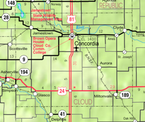
passes through the county, entering from Republic County
to the north and exiting to Clay County
to the east. The Solomon River
traverses the southwestern portion of the county, going from Mitchell County to Ottawa County
. Jamestown Lake
lies partially in the northwestern part of the county and partially in southwestern Republic county.
and connects north to Belleville
, Kansas
or south to Salina
, Kansas
. The southern part of the county also has U.S. Route 24, connecting Clay Center
, Kansas
from the east and Beloit
, Kansas
to the west.
There are four other state highways in the county: K-9
, K-28
, K-189
, and K-194
.
 As of the U.S. Census in 2000
, there were 10,268 people, 4,163 households, and 2,697 families residing in the county. The population density
was 14 people per square mile (6/km²). There were 4,838 housing units at an average density of 7 per square mile (3/km²). The racial makeup
of the county was 98.30% White
, 0.34% Black or African American
, 0.25% Native American
, 0.25% Asian
, 0.13% from other races, and 0.73% from two or more races
. Hispanic
or Latino
of any race were 0.60% of the population.
There were 4,163 household
s out of which 27.10% had children under the age of 18 living with them, 55.10% were married couples
living together, 6.60% had a female householder with no husband present, and 35.20% were non-families. 30.80% of all households were made up of individuals and 15.90% had someone living alone who was 65 years of age or older. The average household size was 2.31 and the average family size was 2.89.
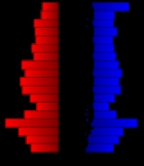
In the county the population was spread out with 22.40% under the age of 18, 10.40% from 18 to 24, 21.90% from 25 to 44, 22.20% from 45 to 64, and 23.20% who were 65 years of age or older. The median age was 41 years. For every 100 females there were 90.60 males. For every 100 females age 18 and over, there were 86.60 males.
The median income for a household
in the county was $31,758, and the median income for a family was $39,745. Males had a median income of $27,166 versus $20,114 for females. The per capita income
for the county was $17,536. About 6.40% of families and 10.80% of the population were below the poverty line, including 12.10% of those under age 18 and 8.70% of those age 65 or over.
. The city of Concordia
is considered governmentally independent and is excluded from the census figures for the townships. In the following table, the population center is the largest city (or cities) included in that township's population total, if it is of a significant size.
Historic
Maps
Kansas
Kansas is a US state located in the Midwestern United States. It is named after the Kansas River which flows through it, which in turn was named after the Kansa Native American tribe, which inhabited the area. The tribe's name is often said to mean "people of the wind" or "people of the south...
, in the Central
Central United States
The Central United States is sometimes conceived as between the Eastern United States and Western United States as part of a three-region model, roughly coincident with the Midwestern United States plus the western and central portions of the Southern United States; the term is also sometimes used...
United States
United States
The United States of America is a federal constitutional republic comprising fifty states and a federal district...
. As of the 2010 census, the county population was 9,533. Its county seat
County seat
A county seat is an administrative center, or seat of government, for a county or civil parish. The term is primarily used in the United States....
and most populous city is Concordia
Concordia, Kansas
Concordia is a city in and the county seat of Cloud County, Kansas, United States. Located on the Republican River in the Smoky Hills region of the Great Plains, Concordia was founded in 1871 and is an economic and cultural center in north-central Kansas...
.
19th century
Cloud county was originally named "Shirley" county, but was later renamed "Cloud" county in honor of Colonel William F. CloudWilliam F. Cloud
William F. Cloud was an officer in the Union Army during the American Civil War who participated in many battles in the Trans-Mississippi Theater.-Early life and career:...
.
Cloud County was formed from the existing Washington County, Kansas
Washington County, Kansas
Washington County is a county located in the U.S. state of Kansas. As of the 2010 census, the county population was 5,799...
in a joint convention with Republic
Republic County, Kansas
Republic County is a county located in the state of Kansas. As of the 2010 census, the county population was 4,980. The largest city and county seat is Belleville.-19th century:...
and Cloud counties. The county was legally organized on September 6, 1866 with Elk Creek designated as the temporary county seat.
In 1887, Atchison, Topeka and Santa Fe Railway
Atchison, Topeka and Santa Fe Railway
The Atchison, Topeka and Santa Fe Railway , often abbreviated as Santa Fe, was one of the larger railroads in the United States. The company was first chartered in February 1859...
built a branch line from Neva (3 miles west of Strong City
Strong City, Kansas
Strong City is a city in Chase County, Kansas, United States. It is named after William Barstow Strong, former president of the Atchison, Topeka and Santa Fe Railway. As of the 2010 census, the city population was 485.-19th century:...
) to Superior, Nebraska
Superior, Nebraska
Superior is a city in Nuckolls County, Nebraska, United States. As of the 2010 census, the city population was 1,957.Superior bills itself as the "Victorian Capital of Nebraska", and holds an annual Victorian Festival...
. This branch line connected Strong City
Strong City, Kansas
Strong City is a city in Chase County, Kansas, United States. It is named after William Barstow Strong, former president of the Atchison, Topeka and Santa Fe Railway. As of the 2010 census, the city population was 485.-19th century:...
, Neva, Rockland, Diamond Springs, Burdick
Burdick, Kansas
Burdick is an unincorporated community in southwestern Morris County, Kansas, United States. It lies along local roads south-southwest of the city of Council Grove, the county seat of Morris County. Its elevation is 1,453 feet , and it is located at...
, Lost Springs
Lost Springs, Kansas
Lost Springs is a city in Marion County, Kansas, United States. It was named for the old lost spring near the city. As of the 2010 census, the city population was 70.-19th century:...
, Jacobs, Hope
Hope, Kansas
Hope is a city in southern Dickinson County, Kansas, United States. As of the 2010 census, the city population was 368. The motto of Hope is "There Will Always Be Hope In Kansas", which is also the name of a song.-History:...
, Navarre
Navarre, Kansas
Navarre is a small unincorporated community in Dickinson County, Kansas, United States. The post office was established February 7, 1884, and discontinued September 3, 1971.-History:...
, Enterprise
Enterprise, Kansas
Enterprise is a city in Dickinson County, Kansas, United States. As of the 2010 census, the city population was 855.-History:On January 10, 1883, the Enterprise Town Company, capital $50,000, was organized. The following officers were elected: V. P. Wilson, president; John Johntz, vice-president;...
, Abilene
Abilene, Kansas
Abilene is a city in and the county seat of Dickinson County, Kansas, United States. As of the 2010 census, the city population was 6,844.-History:...
, Talmage
Talmage, Kansas
Talmage is a small unincorporated community in Dickinson County, Kansas, United States. The post office was established December 22, 1887.-History:...
, Manchester
Manchester, Kansas
Manchester is a city in Dickinson County, Kansas, United States. As of the 2010 census, the city population was 95.-History:In 1887, Atchison, Topeka and Santa Fe Railway built a branch line from Neva through Manchester to Superior, Nebraska...
, Longford
Longford, Kansas
Longford is a city in Clay County, Kansas, United States. As of the 2010 census, the city population was 79.-History:In 1887, Atchison, Topeka and Santa Fe Railway built a branch line from Neva through Longford to Superior, Nebraska...
, Oak Hill
Oak Hill, Kansas
Oak Hill is a city in Clay County, Kansas, United States. As of the 2010 census, the city population was 24.-History:In 1887, Atchison, Topeka and Santa Fe Railway built a branch line from Neva through Oak Hill to Superior, Nebraska...
, Miltonvale
Miltonvale, Kansas
Miltonvale is a city in Cloud County, Kansas, United States. As of the 2010 census, the city population was 539.-History:Miltonvale was founded on December 1, 1881.From 1909 to 1972, it was the home of Miltonvale Wesleyan College....
, Aurora
Aurora, Kansas
Aurora is a city in Cloud County, Kansas, United States. As of the 2010 census, the city population was 60.-History:In 1887, Atchison, Topeka and Santa Fe Railway built a branch line from Neva through Aurora to Superior, Nebraska...
, Huscher
Huscher, Kansas
Huscher is an unincorporated rural area in Cloud County, Kansas, United States.-History:In 1887, Atchison, Topeka and Santa Fe Railway built a branch line from Neva through Huscher to Superior, Nebraska. In 1996, the Atchison, Topeka and Santa Fe Railway merged with Burlington Northern Railroad...
, Concordia
Concordia, Kansas
Concordia is a city in and the county seat of Cloud County, Kansas, United States. Located on the Republican River in the Smoky Hills region of the Great Plains, Concordia was founded in 1871 and is an economic and cultural center in north-central Kansas...
, Kackley
Kackley, Kansas
Kackley is an unincorporated rural area in Republic County, Kansas, United States.-History:In 1887, Atchison, Topeka and Santa Fe Railway built a branch line from Neva through Kackley to Superior, Nebraska. In 1996, the Atchison, Topeka and Santa Fe Railway merged with Burlington Northern...
, Courtland
Courtland, Kansas
Courtland is a city in Republic County, Kansas, United States. As of the 2010 census, the city population was 285.-History:In 1887, Atchison, Topeka and Santa Fe Railway built a branch line from Neva through Courtland to Superior, Nebraska...
, Webber
Webber, Kansas
Webber is a city in Jewell County, Kansas, United States. As of the 2010 census, the city population was 25.-History:In 1887, Atchison, Topeka and Santa Fe Railway built a branch line from Neva through Webber to Superior, Nebraska...
, Superior
Superior, Nebraska
Superior is a city in Nuckolls County, Nebraska, United States. As of the 2010 census, the city population was 1,957.Superior bills itself as the "Victorian Capital of Nebraska", and holds an annual Victorian Festival...
. At some point, the line from Neva to Lost Springs
Lost Springs, Kansas
Lost Springs is a city in Marion County, Kansas, United States. It was named for the old lost spring near the city. As of the 2010 census, the city population was 70.-19th century:...
was pulled but the right of way has not been abandoned. This branch line was originally called "Strong City and Superior line" but later the name was shortened to the "Strong City line". In 1996, the Atchison, Topeka and Santa Fe Railway
Atchison, Topeka and Santa Fe Railway
The Atchison, Topeka and Santa Fe Railway , often abbreviated as Santa Fe, was one of the larger railroads in the United States. The company was first chartered in February 1859...
merged with Burlington Northern Railroad
Burlington Northern Railroad
The Burlington Northern Railroad was a United States-based railroad company formed from a merger of four major U.S. railroads. Burlington Northern operated between 1970 and 1996....
and renamed to the current BNSF Railway
BNSF Railway
The BNSF Railway is a wholly owned subsidiary of Berkshire Hathaway Inc., and is headquartered in Fort Worth, Texas. It is one of seven North American Class I railroads and the second largest freight railroad network in North America, second only to the Union Pacific Railroad, its primary...
. Most locals still refer to this railroad as the "Santa Fe".
Law and government
Following amendment to the Kansas Constitution in 1986, the county remained a prohibition, or "dry"Dry county
A dry county is a county in the United States whose government forbids the sale of alcoholic beverages. Some prohibit off-premises sale, some prohibit on-premises sale, and some prohibit both. Hundreds of dry counties exist across the United States, almost all of them in the South...
, county until 1998, when voters approved the sale of alcoholic liquor by the individual drink with a 30% food sales requirement.
Geography
According to the 2000 census, the county has a total area of 718.47 square miles (1,860.8 km²), of which 715.63 square miles (1,853.5 km²) (or 99.60%) is land and 2.84 square miles (7.4 km²) (or 0.40%) is water.Geographic features
The Republican RiverRepublican River
The Republican River is a river in the central Great Plains of North America, flowing through the U.S. states of Nebraska and Kansas.-Geography:...
passes through the county, entering from Republic County
Republic County, Kansas
Republic County is a county located in the state of Kansas. As of the 2010 census, the county population was 4,980. The largest city and county seat is Belleville.-19th century:...
to the north and exiting to Clay County
Clay County, Kansas
Clay County is a county located in North Central Kansas, in the Central United States. As of the 2010 census, the county population was 8,535...
to the east. The Solomon River
Solomon River
The Solomon River, often referred to as the "Solomon Fork", is a river in the central Great Plains of North America. The entire length of the river lies in the U.S. state of Kansas. It is a tributary of the Smoky Hill River.-Names:...
traverses the southwestern portion of the county, going from Mitchell County to Ottawa County
Ottawa County, Kansas
Ottawa County is a county located in the U.S. state of Kansas. As of the 2010 census, the county population was 6,091. The largest city and county seat is Minneapolis...
. Jamestown Lake
Jamestown (Kansas) Wildlife Area
Jamestown Wildlife Area consist of in Northern Kansas. It is located primarily in Republic County, Kansas and partially in Cloud County, Kansas. Driving directions are North and West of Jamestown, Kansas. The area is commonly called "Jamestown Lake" by local residents.The area is popular...
lies partially in the northwestern part of the county and partially in southwestern Republic county.
Major highways
Cloud County is bisected from north to south by U.S. Route 81, which runs through the town of ConcordiaConcordia, Kansas
Concordia is a city in and the county seat of Cloud County, Kansas, United States. Located on the Republican River in the Smoky Hills region of the Great Plains, Concordia was founded in 1871 and is an economic and cultural center in north-central Kansas...
and connects north to Belleville
Belleville, Kansas
Belleville is a city in and the county seat of Republic County, Kansas, United States. As of the 2010 census, the city population was 1,991.-Geography:Belleville is located at...
, Kansas
Kansas
Kansas is a US state located in the Midwestern United States. It is named after the Kansas River which flows through it, which in turn was named after the Kansa Native American tribe, which inhabited the area. The tribe's name is often said to mean "people of the wind" or "people of the south...
or south to Salina
Salina, Kansas
Salina is a city in and the county seat of Saline County, Kansas, United States. As of the 2010 census, the city population was 47,707. Located in one of the world's largest wheat-producing areas, Salina is a regional trade center for north-central Kansas...
, Kansas
Kansas
Kansas is a US state located in the Midwestern United States. It is named after the Kansas River which flows through it, which in turn was named after the Kansa Native American tribe, which inhabited the area. The tribe's name is often said to mean "people of the wind" or "people of the south...
. The southern part of the county also has U.S. Route 24, connecting Clay Center
Clay Center, Kansas
Clay Center is a city in and the county seat of Clay County, Kansas, United States. As of the 2010 census, the city population was 4,334.-Geography:Clay Center is located at...
, Kansas
Kansas
Kansas is a US state located in the Midwestern United States. It is named after the Kansas River which flows through it, which in turn was named after the Kansa Native American tribe, which inhabited the area. The tribe's name is often said to mean "people of the wind" or "people of the south...
from the east and Beloit
Beloit, Kansas
Beloit is a city in and the county seat of Mitchell County, Kansas, United States. As of the 2010 census, the city population was 3,835.- History :...
, Kansas
Kansas
Kansas is a US state located in the Midwestern United States. It is named after the Kansas River which flows through it, which in turn was named after the Kansa Native American tribe, which inhabited the area. The tribe's name is often said to mean "people of the wind" or "people of the south...
to the west.
There are four other state highways in the county: K-9
K-9 (Kansas highway)
K-9 is a state highway in the U.S. state of Kansas. The highway goes east–west through Kansas. It has its western terminus south of Dresden at an intersection with K-123 and an eastern terminus at its junction with U.S. Route 73 near Lancaster....
, K-28
K-28 (Kansas highway)
K-28 is a state highway in the U.S. state of Kansas. It links U.S. Route 81 from Concordia to the Nebraska state line, where it becomes Nebraska Highway 78. K-28 is one of the original Kansas highways.- References :*...
, K-189
K-189 (Kansas highway)
K-189 is a state highway in the U.S. state of Kansas. It links U.S. Route 24 to Miltonvale, Kansas, where it terminates. The highway is less than one mile in length and travels in a north–south direction....
, and K-194
K-194 (Kansas highway)
K-194 is a state highway in the U.S. state of Kansas. It links U.S. Route 24 to Simpson, Kansas, where it terminates. The highway is approximately in length and straddles the county line of Cloud and Mitchell counties. The highway travels in a north–south direction.-References:*...
.
Adjacent counties
- Republic CountyRepublic County, KansasRepublic County is a county located in the state of Kansas. As of the 2010 census, the county population was 4,980. The largest city and county seat is Belleville.-19th century:...
(north) - Washington CountyWashington County, KansasWashington County is a county located in the U.S. state of Kansas. As of the 2010 census, the county population was 5,799...
(northeast) - Clay CountyClay County, KansasClay County is a county located in North Central Kansas, in the Central United States. As of the 2010 census, the county population was 8,535...
(east) - Ottawa CountyOttawa County, KansasOttawa County is a county located in the U.S. state of Kansas. As of the 2010 census, the county population was 6,091. The largest city and county seat is Minneapolis...
(south) - Mitchell CountyMitchell County, KansasMitchell County is a county located in the U.S. state of Kansas. As of the 2010 census, the county population was 6,373...
(west) - Jewell CountyJewell County, KansasJewell County is a county located in North Central Kansas, in the Central United States. As of the 2010 census, the county population was 3,077. Its county seat and most populous city is Mankato.-19th century:...
(northwest)
Demographics
United States Census, 2000
The Twenty-second United States Census, known as Census 2000 and conducted by the Census Bureau, determined the resident population of the United States on April 1, 2000, to be 281,421,906, an increase of 13.2% over the 248,709,873 persons enumerated during the 1990 Census...
, there were 10,268 people, 4,163 households, and 2,697 families residing in the county. The population density
Population density
Population density is a measurement of population per unit area or unit volume. It is frequently applied to living organisms, and particularly to humans...
was 14 people per square mile (6/km²). There were 4,838 housing units at an average density of 7 per square mile (3/km²). The racial makeup
Race (United States Census)
Race and ethnicity in the United States Census, as defined by the Federal Office of Management and Budget and the United States Census Bureau, are self-identification data items in which residents choose the race or races with which they most closely identify, and indicate whether or not they are...
of the county was 98.30% White
White American
White Americans are people of the United States who are considered or consider themselves White. The United States Census Bureau defines White people as those "having origins in any of the original peoples of Europe, the Middle East, or North Africa...
, 0.34% Black or African American
African American
African Americans are citizens or residents of the United States who have at least partial ancestry from any of the native populations of Sub-Saharan Africa and are the direct descendants of enslaved Africans within the boundaries of the present United States...
, 0.25% Native American
Native Americans in the United States
Native Americans in the United States are the indigenous peoples in North America within the boundaries of the present-day continental United States, parts of Alaska, and the island state of Hawaii. They are composed of numerous, distinct tribes, states, and ethnic groups, many of which survive as...
, 0.25% Asian
Asian American
Asian Americans are Americans of Asian descent. The U.S. Census Bureau definition of Asians as "Asian” refers to a person having origins in any of the original peoples of the Far East, Southeast Asia, or the Indian subcontinent, including, for example, Cambodia, China, India, Indonesia, Japan,...
, 0.13% from other races, and 0.73% from two or more races
Multiracial
The terms multiracial and mixed-race describe people whose ancestries come from multiple races. Unlike the term biracial, which often is only used to refer to having parents or grandparents of two different races, the term multiracial may encompass biracial people but can also include people with...
. Hispanic
Hispanic
Hispanic is a term that originally denoted a relationship to Hispania, which is to say the Iberian Peninsula: Andorra, Gibraltar, Portugal and Spain. During the Modern Era, Hispanic sometimes takes on a more limited meaning, particularly in the United States, where the term means a person of ...
or Latino
Latino
The demonyms Latino and Latina , are defined in English language dictionaries as:* "a person of Latin-American descent."* "A Latin American."* "A person of Hispanic, especially Latin-American, descent, often one living in the United States."...
of any race were 0.60% of the population.
There were 4,163 household
Household
The household is "the basic residential unit in which economic production, consumption, inheritance, child rearing, and shelter are organized and carried out"; [the household] "may or may not be synonymous with family"....
s out of which 27.10% had children under the age of 18 living with them, 55.10% were married couples
Marriage
Marriage is a social union or legal contract between people that creates kinship. It is an institution in which interpersonal relationships, usually intimate and sexual, are acknowledged in a variety of ways, depending on the culture or subculture in which it is found...
living together, 6.60% had a female householder with no husband present, and 35.20% were non-families. 30.80% of all households were made up of individuals and 15.90% had someone living alone who was 65 years of age or older. The average household size was 2.31 and the average family size was 2.89.
In the county the population was spread out with 22.40% under the age of 18, 10.40% from 18 to 24, 21.90% from 25 to 44, 22.20% from 45 to 64, and 23.20% who were 65 years of age or older. The median age was 41 years. For every 100 females there were 90.60 males. For every 100 females age 18 and over, there were 86.60 males.
The median income for a household
Median household income
The median household income is commonly used to generate data about geographic areas and divides households into two equal segments with the first half of households earning less than the median household income and the other half earning more...
in the county was $31,758, and the median income for a family was $39,745. Males had a median income of $27,166 versus $20,114 for females. The per capita income
Per capita income
Per capita income or income per person is a measure of mean income within an economic aggregate, such as a country or city. It is calculated by taking a measure of all sources of income in the aggregate and dividing it by the total population...
for the county was $17,536. About 6.40% of families and 10.80% of the population were below the poverty line, including 12.10% of those under age 18 and 8.70% of those age 65 or over.
Incorporated cities
Name and population ( estimate):- ConcordiaConcordia, KansasConcordia is a city in and the county seat of Cloud County, Kansas, United States. Located on the Republican River in the Smoky Hills region of the Great Plains, Concordia was founded in 1871 and is an economic and cultural center in north-central Kansas...
, (county seat) - ClydeClyde, KansasClyde is a city in Cloud County, Kansas, United States. As of the 2010 census, the city population was 716. Clyde is named for Clyde, Ohio and was originally known as Hamilton.-Geography:Clyde is located at...
, - GlascoGlasco, KansasGlasco is a city in Cloud County, Kansas, United States. As of the 2010 census, the city population was 498.-History:The land that now makes up Glasco was part of a land grant from the U.S. Government to Isaac Biggs, one of the earliest pioneers. Glasco was originally incorporated as "The Dell...
, - MiltonvaleMiltonvale, KansasMiltonvale is a city in Cloud County, Kansas, United States. As of the 2010 census, the city population was 539.-History:Miltonvale was founded on December 1, 1881.From 1909 to 1972, it was the home of Miltonvale Wesleyan College....
, - JamestownJamestown, KansasJamestown is a city in Cloud County, Kansas, United States. As of the 2010 census, the city population was 286.-1911 fire:In 1911 the entire downtown shopping district was destroyed by a fire...
, - SimpsonSimpson, KansasSimpson is a city in Cloud and Mitchell counties in Kansas, United States. As of the 2010 census, the city population was 86.-Geography:Simpson is located at...
, , of which only a small portion lies in the county, the majority of the area and population being in Mitchell CountyMitchell County, KansasMitchell County is a county located in the U.S. state of Kansas. As of the 2010 census, the county population was 6,373... - AuroraAurora, KansasAurora is a city in Cloud County, Kansas, United States. As of the 2010 census, the city population was 60.-History:In 1887, Atchison, Topeka and Santa Fe Railway built a branch line from Neva through Aurora to Superior, Nebraska...
,
Unincorporated places
- AmesAmes, KansasAmes is an unincorporated rural area in Cloud County, Kansas, United States.-See also:* Central Branch Union Pacific Railroad...
- Como
- Cook
- Cool
- Hannum
- HollisHollis, KansasHollis is an unincorporated rural area in Cloud County, Kansas, United States.-History:thumb|right|1909 tornado damageA tornado hit Hollis on May 14, 1909 at five o'clock in the evening...
- HuscherHuscher, KansasHuscher is an unincorporated rural area in Cloud County, Kansas, United States.-History:In 1887, Atchison, Topeka and Santa Fe Railway built a branch line from Neva through Huscher to Superior, Nebraska. In 1996, the Atchison, Topeka and Santa Fe Railway merged with Burlington Northern Railroad...
- Lawrenceburg
- Macyville
- Meredith
- Minersville
- Nelson
- Oneonta
- Princeville
- RiceRice, KansasRice is an unincorporated rural community in Cloud County, Kansas, United States. It is located a significant distance away from Rice County, Kansas....
- Rosaco
- Saint JosephSt. Joseph, KansasSt. Joseph is an unincorporated rural area in Cloud County, Kansas, United States....
- SibleySibley, KansasSibley was a settlement in Cloud County, Kansas, United States north of Concordia and the Republican River. It was once in the running for the county seat but lost in a 1870 run-off election against Concordia. The area is now abandoned as a town and the land is privately owned and used for farming...
- Sulphur Springs
- YumaYuma, KansasYuma is an unincorporated rural area in Cloud County, Kansas, United States. It is located near the intersections of K-28 and County Road 777. A historical marker remains where the town once stood, which was populated from 1878 until the 1930's.-References:...
Townships
Cloud County is divided into eighteen townshipsCivil township
A civil township is a widely used unit of local government in the United States, subordinate to, and geographic divisions of, a county. Specific responsibilities and the degree of autonomy vary based on each state. Civil townships are distinct from survey townships, but in states that have both,...
. The city of Concordia
Concordia, Kansas
Concordia is a city in and the county seat of Cloud County, Kansas, United States. Located on the Republican River in the Smoky Hills region of the Great Plains, Concordia was founded in 1871 and is an economic and cultural center in north-central Kansas...
is considered governmentally independent and is excluded from the census figures for the townships. In the following table, the population center is the largest city (or cities) included in that township's population total, if it is of a significant size.
| Township | FIPS | Population center |
Population | Population density /km² (/sq mi) |
Land area km² (sq mi) | Water area km² (sq mi) | Water % | Geographic coordinates |
|---|---|---|---|---|---|---|---|---|
| Arion | 02275 | 105 | 1 (3) | 94 (36) | 0 (0) | 0.06% | 39°28′28"N 97°44′42"W | |
| Aurora | 03450 | 169 | 2 (5) | 94 (36) | 0 (0) | 0.03% | 39°26′27"N 97°32′2"W | |
| Buffalo | 09100 | 119 | 1 (3) | 112 (43) | 1 (0) | 0.46% | 39°35′12"N 97°45′13"W | |
| Center | 11625 | 172 | 1 (3) | 141 (54) | 0 (0) | 0 % | 39°26′51"N 97°38′45"W | |
| Colfax | 14775 | 49 | 1 (1) | 93 (36) | 0 (0) | 0.05% | 39°26′6"N 97°25′19"W | |
| Elk | 20150 | 845 | 12 (30) | 72 (28) | 1 (0) | 1.08% | 39°35′51"N 97°24′16"W | |
| Grant | 27525 | 479 | 5 (14) | 92 (35) | 2 (1) | 1.75% | 39°36′6"N 97°52′7"W | |
| Lawrence | 38875 | 146 | 2 (4) | 93 (36) | 1 (0) | 1.22% | 39°36′18"N 97°32′41"W | |
| Lincoln | 40525 | 378 | 6 (16) | 61 (24) | 1 (0) | 1.21% | 39°33′20"N 97°39′5"W | |
| Lyon | 43425 | 103 | 1 (2) | 142 (55) | 0 (0) | 0.02% | 39°22′2"N 97°46′20"W | |
| Meredith | 45925 | 77 | 1 (2) | 94 (36) | 0 (0) | 0.03% | 39°21′1"N 97°38′53"W | |
| Nelson | 49600 | 137 | 2 (4) | 91 (35) | 0 (0) | 0 % | 39°30′55"N 97°31′36"W | |
| Oakland | 51750 | 52 | 1 (1) | 93 (36) | 0 (0) | 0.15% | 39°21′44"N 97°31′44"W | |
| Shirley | 65375 | 178 | 2 (4) | 110 (42) | 1 (0) | 0.60% | 39°32′47"N 97°26′5"W | |
| Sibley | 65425 | 178 | 2 (5) | 92 (35) | 1 (1) | 1.45% | 39°36′54"N 97°42′5"W | |
| Solomon | 66250 | 664 | 5 (12) | 141 (54) | 0 (0) | 0 % | 39°21′49"N 97°51′34"W | |
| Starr | 68050 | 653 | 7 (18) | 92 (36) | 0 (0) | 0.21% | 39°20′52"N 97°26′42"W | |
| Summit | 69050 | 50 | 0 (1) | 139 (54) | 0 (0) | 0 % | 39°30′11"N 97°51′59"W | |
| Sources: | ||||||||
Unified school districts
- Concordia USD 333
- Concordia Junior-Senior High SchoolConcordia Junior-Senior High SchoolConcordia Junior-Senior High School is located in Concordia, Kansas and is a part of Unified School District #333. It is called the "Junior-Senior" high school because the junior high school and senior high school are housed in the same building complex.-Junior High, Senior High, and Middle...
- Concordia Middle School
- Concordia Junior-Senior High School
- Southern Cloud County USD 334
- Clifton-Clyde USD 224
Colleges and Universities
- Cloud County Community CollegeCloud County Community CollegeCloud County Community College is a two-year public community college with campuses in Concordia, Kansas population 5,395, and Junction City, Kansas, United States population 23,353.-Concordia campus:...
Historic
- Miltonvale Wesleyan CollegeMiltonvale Wesleyan CollegeMiltonvale Wesleyan College was a two-year college located in Miltonvale, Kansas and was operated by the Wesleyan Church. The school began operation in 1909 under Rev. Silas W. Bond and ceased operation in 1972, when the school merged with Bartlesville Wesleyan College--later to become a part of...
(closed 1972) - Concordia Normal SchoolConcordia Normal SchoolConcordia Normal School located in Concordia, Kansas was a state-funded normal school operated by the Kansas state government from 1874 until 1876....
(closed 1876) - Concordia Business College (closed sometime after 1930)
See also
- National Register of Historic Places listings in Cloud County, KansasNational Register of Historic Places listings in Cloud County, KansasThis is a list of the National Register of Historic Places listings in Cloud County, Kansas.This is intended to be a complete list of the properties and districts on the National Register of Historic Places in Cloud County, Kansas, United States...
Further reading
- History of the State of Kansas; William G. Cutler; A.T. Andreas Publisher; 1883. (Online HTML eBook)
- Kansas : A Cyclopedia of State History, Embracing Events, Institutions, Industries, Counties, Cities, Towns, Prominent Persons, Etc; 3 Volumes; Frank W. Blackmar; Standard Publishing Co; 944 / 955 / 824 pages; 1912. (Volume1 - Download 54MB PDF eBook),(Volume2 - Download 53MB PDF eBook), (Volume3 - Download 33MB PDF eBook)
External links
County- Cloud County - Official Website
- Cloud County - Directory of Public Officials
- Cloud County - Information, Skyways
Maps
- Cloud County Map, KDOT
- Kansas Highway Map, KDOT
- Kansas Railroad Map, KDOT
- Kansas School District Boundary Map, KSDE