.gif)
Rattlesnake Mountain (Connecticut)
Encyclopedia
Rattlesnake Mountain is a traprock mountain, 750 feet (228.6 m) above sea level
, located 9 miles (14 km) southwest of Hartford, Connecticut
in the town of Farmington
. It is part of the narrow, linear Metacomet Ridge
that extends from Long Island Sound
near New Haven, Connecticut
, north through the Connecticut River Valley of Massachusetts
to the Vermont
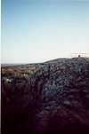
border. Rattlesnake Mountain, a popular outdoor recreation resource of the metropolitan Hartford area, is known for its cliff-top scenic vistas, unique microclimate
ecosystems, and rare plant communities. Will Warren's Den, a boulder cave located on the mountain, is a local historic site. Rattlesnake Mountain is traversed by the 51 miles (82.1 km) Metacomet Trail
.
valley to the west. The mountain consists of an upper summit cone that descends into a series of tiered ridges which become contiguous with the Metacomet Ridge on Pinnacle Rock
to the south and Farmington Mountain
to the north.
A small traprock quarry, 0.4 miles (600 m) wide, occupies the northeast side of the mountain, and a suburban development the southwest side. Two broadcasting towers (WTIC-TV and WVIT) stand on the summit.
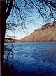
The east side of Rattlesnake Mountain drains into Trout Brook, then to the Park River
, thence into the Connecticut River
and Long Island Sound
; the west side into the Pequabuck River, then to the Farmington River
, thence to the Connecticut River. The south side of the mountain supports the headwaters of the Quinnipiac River
, which flows directly into Long Island Sound.
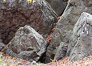
, also called traprock, a volcanic rock. The mountain formed near the end of the Triassic Period with the rifting apart of the North America
n continent from Africa
and Eurasia
. Lava
welled up from the rift and solidified into sheets of strata hundreds of feet thick. Subsequent faulting and earthquake
activity tilted the strata, creating the cliffs and ridgeline of Rattlesnake Mountain. Hot, dry upper slopes, cool, moist ravines, and mineral-rich ledges of basalt talus
produce a combination of microclimate
ecosystems on the mountain that support plant and animal species uncommon in greater Connecticut. Rattlesnake Mountain is also an important raptor migration path. (See Metacomet Ridge
for more information on the geology and ecosystem of Rattlesnake Mountain).
 Will Warren's Den, a boulder cave located on the west side of the mountain, is a historic landmark of the town of Farmington. A plaque affixed to the cave reads, "Said Warren, according to legend, after being flogged for not going to church, tried to burn the village of Farmington. He was pursued into the mountains, where some Indian squaws hid him in this cave." The cave is accessible from the Metacomet Trail.
of Meriden, Connecticut
to the Massachusetts border. Rattlesnake Mountain offers a number of clifftop views west over the Pequabuck River valley toward the eastern escarpment of the Berkshire Mountains. Suburban Farmington is visible below. The mountain is open to hiking
, bird watching, picnicking, snowshoeing, and other passive pursuits. A number of rock climbing
websites indicate several climbing route
s on the mountain.
The ecosystem of Rattlesnake Mountain is most threatened by development and quarrying. In 2000, Rattlesnake Mountain was included in a study by the National Park Service
for the designation of a new National Scenic Trail
now tentatively called the New England National Scenic Trail
, which would include the Metacomet-Monadnock Trail
in Massachusetts and the Mattabesett Trail
and Metacomet Trail
trails in Connecticut.
The Farmington Land Trust http://www.farmingtonlandtrust.org/Index.html is active in the conservation of Rattlesnake Mountain and its viewshed
. Will Warren's Den (part of the William S. Wadsworth Memorial property) is among the many easements managed by the trust.
Sea level
Mean sea level is a measure of the average height of the ocean's surface ; used as a standard in reckoning land elevation...
, located 9 miles (14 km) southwest of Hartford, Connecticut
Hartford, Connecticut
Hartford is the capital of the U.S. state of Connecticut. The seat of Hartford County until Connecticut disbanded county government in 1960, it is the second most populous city on New England's largest river, the Connecticut River. As of the 2010 Census, Hartford's population was 124,775, making...
in the town of Farmington
Farmington, Connecticut
Farmington is a town located in Hartford County in the Farmington Valley area of central Connecticut in the United States. The population was 25,340 at the 2010 census. It is home to the world headquarters of several large corporations including Carrier Corporation, Otis Elevator Company, and Carvel...
. It is part of the narrow, linear Metacomet Ridge
Metacomet Ridge
The Metacomet Ridge, Metacomet Ridge Mountains, or Metacomet Range of southern New England, United States, is a narrow and steep fault-block mountain ridge known for its extensive cliff faces, scenic vistas, microclimate ecosystems, and communities of plants considered rare or endangered...
that extends from Long Island Sound
Long Island Sound
Long Island Sound is an estuary of the Atlantic Ocean, located in the United States between Connecticut to the north and Long Island, New York to the south. The mouth of the Connecticut River at Old Saybrook, Connecticut, empties into the sound. On its western end the sound is bounded by the Bronx...
near New Haven, Connecticut
New Haven, Connecticut
New Haven is the second-largest city in Connecticut and the sixth-largest in New England. According to the 2010 Census, New Haven's population increased by 5.0% between 2000 and 2010, a rate higher than that of the State of Connecticut, and higher than that of the state's five largest cities, and...
, north through the Connecticut River Valley of Massachusetts
Massachusetts
The Commonwealth of Massachusetts is a state in the New England region of the northeastern United States of America. It is bordered by Rhode Island and Connecticut to the south, New York to the west, and Vermont and New Hampshire to the north; at its east lies the Atlantic Ocean. As of the 2010...
to the Vermont
Vermont
Vermont is a state in the New England region of the northeastern United States of America. The state ranks 43rd in land area, , and 45th in total area. Its population according to the 2010 census, 630,337, is the second smallest in the country, larger only than Wyoming. It is the only New England...
border. Rattlesnake Mountain, a popular outdoor recreation resource of the metropolitan Hartford area, is known for its cliff-top scenic vistas, unique microclimate
Microclimate
A microclimate is a local atmospheric zone where the climate differs from the surrounding area. The term may refer to areas as small as a few square feet or as large as many square miles...
ecosystems, and rare plant communities. Will Warren's Den, a boulder cave located on the mountain, is a local historic site. Rattlesnake Mountain is traversed by the 51 miles (82.1 km) Metacomet Trail
Metacomet Trail
The Metacomet Trail is a Blue-Blazed hiking trail that traverses the Metacomet Ridge of central Connecticut and is a part of the newly designated New England National Scenic Trail. Despite being easily accessible and close to large population centers, the trail is considered remarkably rugged and...
.
Geography
Roughly 1 miles (1.6 km) in diameter, Rattlesnake Mountain rises steeply 500 feet (152.4 m) above the Farmington RiverFarmington River
The Farmington River is a river located in northwest Connecticut, with major tributaries extending into southwest Massachusetts. Via its longest branch , the Farmington's length increases to , making it the Connecticut River's longest tributary by a mere over the major river directly to its...
valley to the west. The mountain consists of an upper summit cone that descends into a series of tiered ridges which become contiguous with the Metacomet Ridge on Pinnacle Rock
Pinnacle Rock (Connecticut)
Pinnacle Rock, , is a traprock mountain peak located southwest of Hartford, Connecticut in the towns of Farmington and Plainville.It is part of the narrow, linear Metacomet Ridge that extends from Long Island Sound near New Haven, Connecticut, north through the Connecticut River Valley of...
to the south and Farmington Mountain
Farmington Mountain
Farmington Mountain, , is a traprock ridge located southwest of Hartford, Connecticut in the town of Farmington. It is part of the narrow, linear Metacomet Ridge that extends from Long Island Sound near New Haven, Connecticut, north through the Connecticut River Valley of Massachusetts to the...
to the north.
A small traprock quarry, 0.4 miles (600 m) wide, occupies the northeast side of the mountain, and a suburban development the southwest side. Two broadcasting towers (WTIC-TV and WVIT) stand on the summit.
The east side of Rattlesnake Mountain drains into Trout Brook, then to the Park River
Park River (Connecticut)
The Park River, sometimes called the Hog River, is a subterranean urban river that flows through and under the city of Hartford, Connecticut. It was diverted underground by the Army Corps of Engineers in 1940. The stated reason for this was to reduce the risk of spring seasonal floods which had...
, thence into the Connecticut River
Connecticut River
The Connecticut River is the largest and longest river in New England, and also an American Heritage River. It flows roughly south, starting from the Fourth Connecticut Lake in New Hampshire. After flowing through the remaining Connecticut Lakes and Lake Francis, it defines the border between the...
and Long Island Sound
Long Island Sound
Long Island Sound is an estuary of the Atlantic Ocean, located in the United States between Connecticut to the north and Long Island, New York to the south. The mouth of the Connecticut River at Old Saybrook, Connecticut, empties into the sound. On its western end the sound is bounded by the Bronx...
; the west side into the Pequabuck River, then to the Farmington River
Farmington River
The Farmington River is a river located in northwest Connecticut, with major tributaries extending into southwest Massachusetts. Via its longest branch , the Farmington's length increases to , making it the Connecticut River's longest tributary by a mere over the major river directly to its...
, thence to the Connecticut River. The south side of the mountain supports the headwaters of the Quinnipiac River
Quinnipiac River
The Quinnipiac River is a river in the New England region of the United States, located entirely in the state of Connecticut.It rises in west central Connecticut from Dead Wood Swamp west of the city of New Britain...
, which flows directly into Long Island Sound.
Geology and ecology
Rattlesnake Mountain, like much of the Metacomet Ridge, is composed of basaltBasalt
Basalt is a common extrusive volcanic rock. It is usually grey to black and fine-grained due to rapid cooling of lava at the surface of a planet. It may be porphyritic containing larger crystals in a fine matrix, or vesicular, or frothy scoria. Unweathered basalt is black or grey...
, also called traprock, a volcanic rock. The mountain formed near the end of the Triassic Period with the rifting apart of the North America
North America
North America is a continent wholly within the Northern Hemisphere and almost wholly within the Western Hemisphere. It is also considered a northern subcontinent of the Americas...
n continent from Africa
Africa
Africa is the world's second largest and second most populous continent, after Asia. At about 30.2 million km² including adjacent islands, it covers 6% of the Earth's total surface area and 20.4% of the total land area...
and Eurasia
Eurasia
Eurasia is a continent or supercontinent comprising the traditional continents of Europe and Asia ; covering about 52,990,000 km2 or about 10.6% of the Earth's surface located primarily in the eastern and northern hemispheres...
. Lava
Lava
Lava refers both to molten rock expelled by a volcano during an eruption and the resulting rock after solidification and cooling. This molten rock is formed in the interior of some planets, including Earth, and some of their satellites. When first erupted from a volcanic vent, lava is a liquid at...
welled up from the rift and solidified into sheets of strata hundreds of feet thick. Subsequent faulting and earthquake
Earthquake
An earthquake is the result of a sudden release of energy in the Earth's crust that creates seismic waves. The seismicity, seismism or seismic activity of an area refers to the frequency, type and size of earthquakes experienced over a period of time...
activity tilted the strata, creating the cliffs and ridgeline of Rattlesnake Mountain. Hot, dry upper slopes, cool, moist ravines, and mineral-rich ledges of basalt talus
Scree
Scree, also called talus, is a term given to an accumulation of broken rock fragments at the base of crags, mountain cliffs, or valley shoulders. Landforms associated with these materials are sometimes called scree slopes or talus piles...
produce a combination of microclimate
Microclimate
A microclimate is a local atmospheric zone where the climate differs from the surrounding area. The term may refer to areas as small as a few square feet or as large as many square miles...
ecosystems on the mountain that support plant and animal species uncommon in greater Connecticut. Rattlesnake Mountain is also an important raptor migration path. (See Metacomet Ridge
Metacomet Ridge
The Metacomet Ridge, Metacomet Ridge Mountains, or Metacomet Range of southern New England, United States, is a narrow and steep fault-block mountain ridge known for its extensive cliff faces, scenic vistas, microclimate ecosystems, and communities of plants considered rare or endangered...
for more information on the geology and ecosystem of Rattlesnake Mountain).
Folklore
Recreation and conservation
Rattlesnake Mountain is traversed by the Metacomet Trail, (maintained by the Connecticut Forest and Park Association), which extends from the Hanging HillsHanging Hills
The Hanging Hills of south central Connecticut, USA are a range of mountainous trap rock ridges overlooking the city of Meriden and the Quinnipiac River Valley below. They are a sub-range of the narrow, linear Metacomet Ridge that extends from Long Island Sound near New Haven, Connecticut, north...
of Meriden, Connecticut
Meriden, Connecticut
Meriden is a city in New Haven County, Connecticut, United States. According to 2005 Census Bureau estimates, the population of the city is 59,653.-History:...
to the Massachusetts border. Rattlesnake Mountain offers a number of clifftop views west over the Pequabuck River valley toward the eastern escarpment of the Berkshire Mountains. Suburban Farmington is visible below. The mountain is open to hiking
Hiking
Hiking is an outdoor activity which consists of walking in natural environments, often in mountainous or other scenic terrain. People often hike on hiking trails. It is such a popular activity that there are numerous hiking organizations worldwide. The health benefits of different types of hiking...
, bird watching, picnicking, snowshoeing, and other passive pursuits. A number of rock climbing
Rock climbing
Rock climbing also lightly called 'The Gravity Game', is a sport in which participants climb up, down or across natural rock formations or artificial rock walls. The goal is to reach the summit of a formation or the endpoint of a pre-defined route without falling...
websites indicate several climbing route
Climbing route
A climbing route is a path by which a climber reaches the top of a mountain, rock, or ice wall. Routes can vary dramatically in difficulty and, once committed to that ascent, can be difficult to stop or return. Choice of route can be critically important...
s on the mountain.
The ecosystem of Rattlesnake Mountain is most threatened by development and quarrying. In 2000, Rattlesnake Mountain was included in a study by the National Park Service
National Park Service
The National Park Service is the U.S. federal agency that manages all national parks, many national monuments, and other conservation and historical properties with various title designations...
for the designation of a new National Scenic Trail
National Scenic Trail
National Scenic Trail is a designation for protected areas in the United States that consist of trails of particular natural beauty.National Scenic Trails were authorized under the National Trails System Act of 1968 along with National Historic Trails and National Recreation Trails...
now tentatively called the New England National Scenic Trail
New England National Scenic Trail
The New England National Scenic Trail is a National Scenic Trail in southern New England, which includes most of the three single trails Metacomet-Monadnock Trail, Mattabesett Trail and Metacomet Trail. After the Metacomet-Monadnock-Mattabesett trail system, the trail is sometimes called Triple-M...
, which would include the Metacomet-Monadnock Trail
Metacomet-Monadnock Trail
The Metacomet-Monadnock Trail is a hiking trail that traverses the Metacomet Ridge of the Pioneer Valley region of Massachusetts and the central uplands of Massachusetts and southern New Hampshire...
in Massachusetts and the Mattabesett Trail
Mattabesett Trail
The Mattabesett Trail is a long, hook-shaped Blue-Blazed hiking trail in central Connecticut and a part of the newly designated New England National Scenic Trail. One half of the trail follows the high traprock ridges of the Metacomet Ridge, from Totoket Mountain in Guilford, Connecticut to...
and Metacomet Trail
Metacomet Trail
The Metacomet Trail is a Blue-Blazed hiking trail that traverses the Metacomet Ridge of central Connecticut and is a part of the newly designated New England National Scenic Trail. Despite being easily accessible and close to large population centers, the trail is considered remarkably rugged and...
trails in Connecticut.
The Farmington Land Trust http://www.farmingtonlandtrust.org/Index.html is active in the conservation of Rattlesnake Mountain and its viewshed
Viewshed
A viewshed is an area of land, water, or other environmental element that is visible to the human eye from a fixed vantage point. The term is used widely in such areas as urban planning, archaeology, and military science...
. Will Warren's Den (part of the William S. Wadsworth Memorial property) is among the many easements managed by the trust.
See also
- Metacomet RidgeMetacomet RidgeThe Metacomet Ridge, Metacomet Ridge Mountains, or Metacomet Range of southern New England, United States, is a narrow and steep fault-block mountain ridge known for its extensive cliff faces, scenic vistas, microclimate ecosystems, and communities of plants considered rare or endangered...
- Adjacent summits:
↓ South North ↑