
.gif)
Park River (Connecticut)
Encyclopedia
41°45′36.1"N 72°39′52.7"W
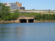
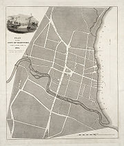 The Park River, sometimes called the Hog River, is a subterranean
urban river that flows through and under the city of Hartford
, Connecticut
. It was diverted underground by the Army Corps of Engineers
in 1940. The stated reason for this was to reduce the risk of spring seasonal flood
s which had occurred in the city due to the increase in surface runoff
from urban development. The river is 2.3 miles (3.7 km) long.
 Prior to European settlement the Suckiaug
people lived on the fertile banks of the Connecticut
and Park rivers, their name derived from the word sucki-auke, meaning "black earth". In 1623, fur traders from the Dutch West India Company
set up Fort Goede Hoop at the confluence of the Connecticut and Park Rivers. The Dutch called the river the "Little River", in contrast to its larger counterpart the Great River (Connecticut River). The first English settlers arrived in 1635, and shortly thereafter, in 1636, the Reverend Thomas Hooker
led 100 of his congregation to form a new settlement north of the Dutch fort. In this year, the first mill in Hartford was built on the Little River by Matthew Allyn
for grinding the corn that grew in the area. In the coming years more mills were built upon the banks of the Little River, leading to it being known as Mill River.
The North Branch Park River watershed is a 28.6 square-mile basin within the Park watershed. Four major tributaries– Beamans Brook, Wash Brook, Filley Brook, and Tumbledown Brook – drain from Bloomfield and northern parts of West Hartford converging near the University of Hartford to form the North Branch of the Park River. Upstream drainage from the entire watershed flows between the West End, Blue Hills, and Asylum Hill neighborhoods of Hartford, Connecticut’s capital city, before pouring into an underground conduit north of Farmington Avenue, which carries the river and often combined sewage overflows into the Connecticut River.
Subterranean river
A subterranean river is a river that runs wholly or partly beneath the ground surface – one where the riverbed does not represent the surface of the Earth ....
urban river that flows through and under the city of Hartford
Hartford, Connecticut
Hartford is the capital of the U.S. state of Connecticut. The seat of Hartford County until Connecticut disbanded county government in 1960, it is the second most populous city on New England's largest river, the Connecticut River. As of the 2010 Census, Hartford's population was 124,775, making...
, Connecticut
Connecticut
Connecticut is a state in the New England region of the northeastern United States. It is bordered by Rhode Island to the east, Massachusetts to the north, and the state of New York to the west and the south .Connecticut is named for the Connecticut River, the major U.S. river that approximately...
. It was diverted underground by the Army Corps of Engineers
United States Army Corps of Engineers
The United States Army Corps of Engineers is a federal agency and a major Army command made up of some 38,000 civilian and military personnel, making it the world's largest public engineering, design and construction management agency...
in 1940. The stated reason for this was to reduce the risk of spring seasonal flood
Flood
A flood is an overflow of an expanse of water that submerges land. The EU Floods directive defines a flood as a temporary covering by water of land not normally covered by water...
s which had occurred in the city due to the increase in surface runoff
Surface runoff
Surface runoff is the water flow that occurs when soil is infiltrated to full capacity and excess water from rain, meltwater, or other sources flows over the land. This is a major component of the water cycle. Runoff that occurs on surfaces before reaching a channel is also called a nonpoint source...
from urban development. The river is 2.3 miles (3.7 km) long.
History
Suckiaug
Suckiaug, meaning "Black Fertile River-Enhanced Earth, good for planting", is the name of the land lining the river valley of what is currently Hartford, Windsor, Wethersfield, South Windsor, East Hartford, Glastonbury and Rocky Hill in Connecticut in the United States.In 1623, the Dutch settled...
people lived on the fertile banks of the Connecticut
Connecticut River
The Connecticut River is the largest and longest river in New England, and also an American Heritage River. It flows roughly south, starting from the Fourth Connecticut Lake in New Hampshire. After flowing through the remaining Connecticut Lakes and Lake Francis, it defines the border between the...
and Park rivers, their name derived from the word sucki-auke, meaning "black earth". In 1623, fur traders from the Dutch West India Company
Dutch West India Company
Dutch West India Company was a chartered company of Dutch merchants. Among its founding fathers was Willem Usselincx...
set up Fort Goede Hoop at the confluence of the Connecticut and Park Rivers. The Dutch called the river the "Little River", in contrast to its larger counterpart the Great River (Connecticut River). The first English settlers arrived in 1635, and shortly thereafter, in 1636, the Reverend Thomas Hooker
Thomas Hooker
Thomas Hooker was a prominent Puritan colonial leader, who founded the Colony of Connecticut after dissenting with Puritan leaders in Massachusetts...
led 100 of his congregation to form a new settlement north of the Dutch fort. In this year, the first mill in Hartford was built on the Little River by Matthew Allyn
Founders of Hartford, Connecticut
Here are the 163 men and women listed in the Book of Distribution of Land as being those who settled in Hartford, Connecticut before February 1640. Their names are on a monument in Hartford's Ancient Burying Ground....
for grinding the corn that grew in the area. In the coming years more mills were built upon the banks of the Little River, leading to it being known as Mill River.
North Branch Park River Watershed
A watershed, or “drainage basin”, is the area around a river (or section of river) in which all water drains into that particular river. These waters include small bodies of water such as streams and brooks, but also all of the rain water that seeps into the ground. It is extremely important to keep a river’s entire watershed in mind when protecting it because all of the water in this area is connected and will eventually end up in the river itself.The North Branch Park River watershed is a 28.6 square-mile basin within the Park watershed. Four major tributaries– Beamans Brook, Wash Brook, Filley Brook, and Tumbledown Brook – drain from Bloomfield and northern parts of West Hartford converging near the University of Hartford to form the North Branch of the Park River. Upstream drainage from the entire watershed flows between the West End, Blue Hills, and Asylum Hill neighborhoods of Hartford, Connecticut’s capital city, before pouring into an underground conduit north of Farmington Avenue, which carries the river and often combined sewage overflows into the Connecticut River.