
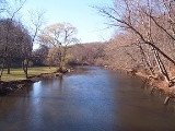
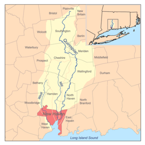
Quinnipiac River
Encyclopedia
River
A river is a natural watercourse, usually freshwater, flowing towards an ocean, a lake, a sea, or another river. In a few cases, a river simply flows into the ground or dries up completely before reaching another body of water. Small rivers may also be called by several other names, including...
in the New England
New England
New England is a region in the northeastern corner of the United States consisting of the six states of Maine, New Hampshire, Vermont, Massachusetts, Rhode Island, and Connecticut...
region of the United States
United States
The United States of America is a federal constitutional republic comprising fifty states and a federal district...
, located entirely in the state of Connecticut
Connecticut
Connecticut is a state in the New England region of the northeastern United States. It is bordered by Rhode Island to the east, Massachusetts to the north, and the state of New York to the west and the south .Connecticut is named for the Connecticut River, the major U.S. river that approximately...
.
It rises in west central Connecticut from Dead Wood Swamp west of the city of New Britain
New Britain, Connecticut
New Britain is a city in Hartford County, Connecticut, United States. It is located approximately 9 miles southwest of Hartford. According to 2006 Census Bureau estimates, the population of the city is 71,254....
. It flows roughly southward to Plainville
Plainville, Connecticut
Plainville is a town in Hartford County, Connecticut, United States. The population was 17,328 at the 2000 census.-Geography:According to the United States Census Bureau, the town has a total area of 9.8 square miles , of which 9.8 square miles is land and 0.1 square miles is water...
, Southington
Southington, Connecticut
Southington is a town in Hartford County, Connecticut, United States. It is part of Connecticut's 1st congressional district. It is situated about 20 miles southwest of Hartford, about 80 miles northeast of New York City, 105 miles southwest of Boston and 77 miles west of Providence...
, and Cheshire
Cheshire, Connecticut
Cheshire is a town in New Haven County, Connecticut, United States. The population was 28,543 at the 2000 census. The center of population of Connecticut is located in Cheshire. In 2009 Cheshire was ranked 72 in Money Magazine's 100 Best Places to Live.Likewise, in 2011 Cheshire was ranked 73 in...
, west of the city of Meriden
Meriden, Connecticut
Meriden is a city in New Haven County, Connecticut, United States. According to 2005 Census Bureau estimates, the population of the city is 59,653.-History:...
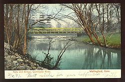
, through Wallingford
Wallingford, Connecticut
Wallingford is a town in New Haven County, Connecticut, United States. The population was 43,026 at the 2000 census.- History :Wallingford was established on October 10, 1667, when the Connecticut General Assembly authorized the "making of a village on the east river" to 38 planters and freemen...
and Yalesville
Yalesville, Connecticut
Yalesville is a village in Wallingford, Connecticut. It was formerly known as First Falls and later as Tyler's Mills.-Geography:Yalesville is located in the NW of Wallingford.The Quinnipiac River and Wharton's Brook run through Yalesville....
, North Haven
North Haven, Connecticut
North Haven is a town in New Haven County, Connecticut on the outskirts of New Haven, Connecticut.North Haven is less than ten miles from downtown New Haven and Yale University. It is near Sleeping Giant State Park and home the Quinnipiac University School of Health Sciences, the School of Nursing,...
, and flows into New Haven Harbor
New Haven Harbor
New Haven Harbor is an inlet on the north side of Long Island Sound in the state of Connecticut in the United States. The harbor area is an inlet carved by the retreat of the glaciers during the last ice age approximately 13,000 years ago....
, an inlet of Long Island Sound
Long Island Sound
Long Island Sound is an estuary of the Atlantic Ocean, located in the United States between Connecticut to the north and Long Island, New York to the south. The mouth of the Connecticut River at Old Saybrook, Connecticut, empties into the sound. On its western end the sound is bounded by the Bronx...
, east of downtown New Haven
New Haven, Connecticut
New Haven is the second-largest city in Connecticut and the sixth-largest in New England. According to the 2010 Census, New Haven's population increased by 5.0% between 2000 and 2010, a rate higher than that of the State of Connecticut, and higher than that of the state's five largest cities, and...
(41.300°N 72.902°W).
It has a total length of 45.5 miles (73.2 km) and a drainage area of approximately 165 square mile. There are four dam
Dam
A dam is a barrier that impounds water or underground streams. Dams generally serve the primary purpose of retaining water, while other structures such as floodgates or levees are used to manage or prevent water flow into specific land regions. Hydropower and pumped-storage hydroelectricity are...
s, most of which are old remnants, that impede boat travel. The first dam is about 1/2 mile south of Plantsville
Plantsville, Connecticut
Plantsville is a neighborhood and census-designated place in the town of Southington, Hartford County, Connecticut. It is centered at the merger between South Main Street and West Main Street...
, the second dam is at the southeast corner of Hanover Pond in South Meriden, the third dam is in northeast Yalesville
Yalesville, Connecticut
Yalesville is a village in Wallingford, Connecticut. It was formerly known as First Falls and later as Tyler's Mills.-Geography:Yalesville is located in the NW of Wallingford.The Quinnipiac River and Wharton's Brook run through Yalesville....
, and the fourth dam is at the south end of Community Lake in Wallingford. Paddling is a frequent recreational activity along the Quinnipiac River, especially within the tidal marsh in North Haven. Additionally, the tidal
Tide
Tides are the rise and fall of sea levels caused by the combined effects of the gravitational forces exerted by the moon and the sun and the rotation of the Earth....
variation extends approximately 14 miles (22.5 km) upriver from its mouth.
The name comes an Algonquian
Algonquian languages
The Algonquian languages also Algonkian) are a subfamily of Native American languages which includes most of the languages in the Algic language family. The name of the Algonquian language family is distinguished from the orthographically similar Algonquin dialect of the Ojibwe language, which is a...
phrase for "long water land", and the name given to the river and the area around its mouth.
Paralleling the west bank of the Quinnipiac River through the entire length of Quinnipiac River State Park in North Haven is the Quinnipiac Trail
Quinnipiac Trail
The Quinnipiac Trail is a Blue-Blazed hiking trail in New Haven County, Connecticut. It is the product of the evolution and growth of the first trail designated in Connecticut's Blue-Blazed Hiking Trail system, with its light-blue rectangular vertical painted blazes .-The route:From its...
.
Throughout the 19th and 20th centuries, the river suffered from severe pollution
Pollution
Pollution is the introduction of contaminants into a natural environment that causes instability, disorder, harm or discomfort to the ecosystem i.e. physical systems or living organisms. Pollution can take the form of chemical substances or energy, such as noise, heat or light...
problems because of the presence of heavy industry and population centers in its watershed. The Quinnipiac was the subject of the first ever pollution control measure in the state of Connecticut. In 1886, the state legislature
Connecticut General Assembly
The Connecticut General Assembly is the state legislature of the U.S. state of Connecticut. It is a bicameral body composed of the 151-member House of Representatives and the 36-member Senate. It meets in the state capital, Hartford. There are no term limits for either chamber.During...
passed a measure prohibiting the City of Meriden from discharging raw sewage
Sewage
Sewage is water-carried waste, in solution or suspension, that is intended to be removed from a community. Also known as wastewater, it is more than 99% water and is characterized by volume or rate of flow, physical condition, chemical constituents and the bacteriological organisms that it contains...
into the river. In 1891, the act resulted in the building of state's first sewage treatment plant.
Nevertheless, by 1914, the State Board of Health reported that the major fish life had largely disappeared from its mouth. The pollution has been somewhat abated by the passage of the Connecticut Clean Water Act of 1967, and by the Water Pollution Control Act of 1972, which provided the legal authority to take measures to clean up the river's watershed. The measures included the construction of advanced waste management facilities for sewage and industrial waste. Levels of copper
Copper
Copper is a chemical element with the symbol Cu and atomic number 29. It is a ductile metal with very high thermal and electrical conductivity. Pure copper is soft and malleable; an exposed surface has a reddish-orange tarnish...
in the river have decreased 70% since the 1980s and are now comparable to other reference streams in Connecticut. Combined sewer overflows from the City of New Haven are still regarded as a major problem for the estuary.
Major crossings
- Tomlinson Bridge (U.S. Route 1)
- Pearl Harbor Memorial BridgePearl Harbor Memorial Bridge (Connecticut)-Bridge plans bring controversy:The existing Q-Bridge opened with a design capacity of 90,000 vehicles per day , but as of 2006 more than 150,000 vehicles cross the span daily...
(Interstate 95) - Ferry Street Bridge
- Grand Avenue Bridge
- I-91 Bridge (Interstate 91Interstate 91Interstate 91 is an Interstate Highway in the New England region of the United States. It provides the primary north–south thoroughfare in the western part of New England...
) - Middletown Avenue Bridge
Bridges north of the Middletown Avenue bridge are relatively minor structures.
External links
- Connecticut Department of Environment Protection: Quinnipiac River
- Quinnipiac River Historic District, New Haven.
- Connecticut Explorer's Guide Online paddling map of the Quinnipiac River