
Rannerdale Knotts
Encyclopedia
Rannerdale Knotts is a fell
in the Lake District
of Cumbria
, England
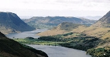
. Rising from the Buttermere
valley, it is one of the smaller Cumbrian hills and is overlooked by a number of surrounding fells, such as Grasmoor
, Whiteless Pike
and, across Crummock Water
, Mellbreak
and the High Stile
ridge. Rannerdale Knotts is said to be the site of a battle between the native Cumbrians and Norsemen
and the invading Normans
in the late 11th or early 12th century.
occupy the area between the rivers Derwent and Cocker, a broadly oval swathe of hilly country, elongated on a north-south axis. Two roads cross from east to west, dividing the fells into three convenient groups. The central sector, rising between Whinlatter Pass
and Newlands Pass
, includes Whiteless Pike.
The highest ground in the North Western Fells is an east-west ridge in this central sector, beginning with Grasmoor
above Crummock Water
and then gradually descending eastwards over Crag Hill
, Sail
, Scar Crags
and Causey Pike
. Grasmoor has the greatest elevation, but Crag Hill stands at the hub of the range. It sends out a subsidiary ridge to the south west, stepping down over Wandope
and Whiteless Pike toward Buttermere village. Just above the village this ridge then turns sharply north west and rises to the summit of Rannerdale Knotts.
The sharp angle in the ridge is marked by a depression at 950 ft, beyond which the ground climbs slowly for around a mile toward the top. This section of the fell is named Low Bank on Ordnance Survey
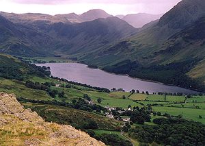
maps and is clad primarily in bracken. The final section bears a series of rocky knolls, still rising slowly north westward. A tumbling descent of crag and scree then follows as the end of the ridge drops steeply to the valley floor, halfway along the shore of Crummock Water. Rannerdale farm lies below this terminal face.
The south western side of Rannerdale Knotts is bounded first by Mill Beck, running through Buttermere village, and then by Crummock Water. The north eastern flank falls to Squat Beck, a feeder of Rannerdale Beck. High Rannerdale lies within the angle of the ridge between Whiteless Pike and Rannerdale Knotts, Rannerdale proper being a triangular patch of pasture constrained by Rannerdale Knotts, Grasmoor and Crummock Water.
rocks, typical of the Skiddaw
massif, are composed of laminated mudstone
and siltstone
. Low Bank lies across the Causey Pike Fault and is part of the Buttermere Formation, an olistostrome
of disrupted sheared and folded mudstone, siltstone and sandstone
. There are also two minor intrusions of basalt
running across the ridgeline..
There is a trial level in the northern crags, above Hause Point on the Crummock Water road. The opening is about 5 ft square but the level extends only a little way into the fell-side. The object appears to have been lead
-bearing galena
of which some traces remain.
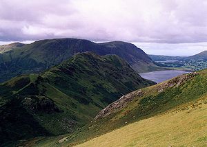
. The view is limited by the circle of higher fells, but the vista of Buttermere backed by Great Gable
is excellent. Crummock Water can also be brought into view by taking a few paces westward.
at 950 feet. There is a more direct ascent up the west face of the fell from Hause Point at Rannerdale, accessed from the B5289 road on the eastern shore of Crummock Water. A larger circuit of Rannerdale can also be made, taking in Grasmoor, Crag Hill, Wandope, Whiteless Pike and Rannerdale Knotts.
Nicholas Size
published a historical novel
in 1930 called The Secret Valley, which tells the story of how this area resisted the Norman invaders in the 50 years after the 1066 Norman invasion
. According to Size, the Norman army was ambushed and defeated by the native Britons and Norsemen at the Battle of Rannerdale.
The battle is thought to have taken place in the side valley of Rannerdale, which runs east of the summit of the fell, west of Whiteless Pike and south of Grasmoor. Bluebell
s grow in profusion in this valley in April and May. According to local folklore
, the bluebells are said to have sprung from the spilt blood of the slain Norman warriors.
A Norman army under the command of Ranulf Meschin, Earl of Carlisle, advanced south from Cockermouth
. (Ranulf Meschin is Size's anglicised version of Norman nobleman Ranulph les Meschines.) The local warriors were commanded by the Earl Boethar, who succeeded in drawing the Normans into the side valley of Rannerdale, then routed them with a surprise attack from above and behind.
 In Size's version, Ranulf Meschin escaped and lived in disgrace until he succeeded a relative as Earl of Chester
in 1120.
Little historical evidence is available to support Size's version of the story, which is a romanticised tale of the last stand of the native Britons against the invading force.
The Buttermere area does not appear in the Domesday Book
, which indicates that this part of Cumbria was not under Norman control in 1086. The central area of the Lake District is known to have been populated by the earlier Norse
invaders in the early 10th century, and dale
is etymologically Norse. Cumbria
was ostensibly part of Scotland, until seized by the forces of William Rufus in 1092, following a dispute with Scottish king Malcolm III, himself killed a year later at the Battle of Alnwick
. William Rufus gave Norman nobleman Ranulph les Meschines lands in Cumbria following this conquest of the area. When Ranulph les Meschines became Earl of Chester, his estates were returned to the Crown. Around 1120, Henry I of England
gave the Barony of Copeland to Ranulph's brother William les Meschines, who settled at then initiated the construction of the castle at Egremont
on Cumbria's western coast.
Size himself died aged 86, having negotiated fiercely with the local district council to be buried on the fells. His grave overlooks Rannerdale. His epitaph reads:
Fell
“Fell” is a word used to refer to mountains, or certain types of mountainous landscape, in Scandinavia, the Isle of Man, and parts of northern England.- Etymology :...
in the Lake District
Lake District
The Lake District, also commonly known as The Lakes or Lakeland, is a mountainous region in North West England. A popular holiday destination, it is famous not only for its lakes and its mountains but also for its associations with the early 19th century poetry and writings of William Wordsworth...
of Cumbria
Cumbria
Cumbria , is a non-metropolitan county in North West England. The county and Cumbria County Council, its local authority, came into existence in 1974 after the passage of the Local Government Act 1972. Cumbria's largest settlement and county town is Carlisle. It consists of six districts, and in...
, England
England
England is a country that is part of the United Kingdom. It shares land borders with Scotland to the north and Wales to the west; the Irish Sea is to the north west, the Celtic Sea to the south west, with the North Sea to the east and the English Channel to the south separating it from continental...
. Rising from the Buttermere
Buttermere
Buttermere is a lake in the English Lake District in North West England. The adjacent village of Buttermere takes its name from the lake. Historically within the former county of Cumberland, the lake is now within the county of Cumbria. It is owned by the National Trust, forming part of their...
valley, it is one of the smaller Cumbrian hills and is overlooked by a number of surrounding fells, such as Grasmoor
Grasmoor
Grasmoor is a mountain in the north-western part of the Lake District, northern England. It is the highest peak in a group of hills between the villages of Lorton, Braithwaite and Buttermere, and overlooks Crummock Water....
, Whiteless Pike
Whiteless Pike
Whiteless Pike is a fell in the north-western English Lake District. It stands immediately east of Crummock Water and forms a perfect pyramid shape when viewed from Rannerdale. In his celebrated guide to the Lakeland fells, Alfred Wainwright called it "the Weisshorn of Buttermere"...
and, across Crummock Water
Crummock Water
Crummock Water is a lake in the Lake District in Cumbria, North West England situated between Buttermere to the south and Loweswater to the north. Crummock Water is two and a half miles long, three quarters of a mile wide and 140ft deep. The River Cocker is considered to start at the north of the...
, Mellbreak
Mellbreak
Mellbreak is a hill in the Western part of the English Lake District. Despite being surrounded on all sides by higher fells , it stands in isolation. It is surrounded on three sides by a 'moat' of deep marshy land, and on the east side by the lake of Crummock Water...
and the High Stile
High Stile
High Stile is a mountain in the western part of the Lake District in northwest England. It is the eleventh highest English Marilyn, standing 807 metres high, and has a relative height of 362 metres ....
ridge. Rannerdale Knotts is said to be the site of a battle between the native Cumbrians and Norsemen
Norsemen
Norsemen is used to refer to the group of people as a whole who spoke what is now called the Old Norse language belonging to the North Germanic branch of Indo-European languages, especially Norwegian, Icelandic, Faroese, Swedish and Danish in their earlier forms.The meaning of Norseman was "people...
and the invading Normans
Normans
The Normans were the people who gave their name to Normandy, a region in northern France. They were descended from Norse Viking conquerors of the territory and the native population of Frankish and Gallo-Roman stock...
in the late 11th or early 12th century.
Topography
The North Western FellsNorth Western Fells
The North Western Fells are a group of hills in the English Lake District. Including such favourites as Catbells and Grisedale Pike, they occupy an oval area beneath the Buttermere and Borrowdale valley systems...
occupy the area between the rivers Derwent and Cocker, a broadly oval swathe of hilly country, elongated on a north-south axis. Two roads cross from east to west, dividing the fells into three convenient groups. The central sector, rising between Whinlatter Pass
Whinlatter Pass
The Whinlatter Pass is a mountain pass in the English Lake District. It is located on the B5292 road linking Braithwaite, to the west of Keswick, with High Lorton to the south of Cockermouth....
and Newlands Pass
Newlands Pass
The Newlands Pass, also known as Newlands Hause, is a mountain pass in the English Lake District. It is located on an unclassified road linking the Newlands Valley, to the west of Keswick and Derwent Water, with the village of Buttermere...
, includes Whiteless Pike.
The highest ground in the North Western Fells is an east-west ridge in this central sector, beginning with Grasmoor
Grasmoor
Grasmoor is a mountain in the north-western part of the Lake District, northern England. It is the highest peak in a group of hills between the villages of Lorton, Braithwaite and Buttermere, and overlooks Crummock Water....
above Crummock Water
Crummock Water
Crummock Water is a lake in the Lake District in Cumbria, North West England situated between Buttermere to the south and Loweswater to the north. Crummock Water is two and a half miles long, three quarters of a mile wide and 140ft deep. The River Cocker is considered to start at the north of the...
and then gradually descending eastwards over Crag Hill
Crag Hill
Crag Hill is a mountain in the North Western part of the English Lake District. It was formerly known as Eel Crag; however, the Ordnance Survey now marks Eel Crag as referring to the northern crags of the fell....
, Sail
Sail (Lake District)
Sail is a hill in the English Lake District, lying between Derwentwater and Crummock Water.-Topography:The North Western Fells occupy the area between the rivers Derwent and Cocker, a broadly oval swathe of hilly country, elongated on a north-south axis. Two roads cross from east to west, dividing...
, Scar Crags
Scar Crags
Scar Crags is a fell in the north western part of the English Lake District in the county of Cumbria. It is one of the Coledale group of fells situated seven kilometres south west of Keswick and reaches a height of 672 metres .-Topography:...
and Causey Pike
Causey Pike
Causey Pike is a fell in the English Lake District. It is situated in the Newlands Valley, 5 km south west of the town of Keswick. Even though it has a modest height of 637 metres it is one of the most distinctive fells when viewed from the Derwent Water and Keswick area due to its...
. Grasmoor has the greatest elevation, but Crag Hill stands at the hub of the range. It sends out a subsidiary ridge to the south west, stepping down over Wandope
Wandope
Wandope is a fell in the north-western area of the English Lake District. It lies to the east of Crummock Water and south of Crag Hill...
and Whiteless Pike toward Buttermere village. Just above the village this ridge then turns sharply north west and rises to the summit of Rannerdale Knotts.
The sharp angle in the ridge is marked by a depression at 950 ft, beyond which the ground climbs slowly for around a mile toward the top. This section of the fell is named Low Bank on Ordnance Survey
Ordnance Survey
Ordnance Survey , an executive agency and non-ministerial government department of the Government of the United Kingdom, is the national mapping agency for Great Britain, producing maps of Great Britain , and one of the world's largest producers of maps.The name reflects its creation together with...
maps and is clad primarily in bracken. The final section bears a series of rocky knolls, still rising slowly north westward. A tumbling descent of crag and scree then follows as the end of the ridge drops steeply to the valley floor, halfway along the shore of Crummock Water. Rannerdale farm lies below this terminal face.
The south western side of Rannerdale Knotts is bounded first by Mill Beck, running through Buttermere village, and then by Crummock Water. The north eastern flank falls to Squat Beck, a feeder of Rannerdale Beck. High Rannerdale lies within the angle of the ridge between Whiteless Pike and Rannerdale Knotts, Rannerdale proper being a triangular patch of pasture constrained by Rannerdale Knotts, Grasmoor and Crummock Water.
Geology and mining
The summit area shows outcropping of the Kirkstile Formation. These OrdovicianOrdovician
The Ordovician is a geologic period and system, the second of six of the Paleozoic Era, and covers the time between 488.3±1.7 to 443.7±1.5 million years ago . It follows the Cambrian Period and is followed by the Silurian Period...
rocks, typical of the Skiddaw
Skiddaw
Skiddaw is a mountain in the Lake District National Park in England. With a summit at 931 m above sea level it is the fourth highest mountain in England. It lies just north of the town of Keswick, Cumbria, and dominates the skyline in this part of the northern lakes...
massif, are composed of laminated mudstone
Mudstone
Mudstone is a fine grained sedimentary rock whose original constituents were clays or muds. Grain size is up to 0.0625 mm with individual grains too small to be distinguished without a microscope. With increased pressure over time the platey clay minerals may become aligned, with the...
and siltstone
Siltstone
Siltstone is a sedimentary rock which has a grain size in the silt range, finer than sandstone and coarser than claystones.- Description :As its name implies, it is primarily composed of silt sized particles, defined as grains 1/16 - 1/256 mm or 4 to 8 on the Krumbein phi scale...
. Low Bank lies across the Causey Pike Fault and is part of the Buttermere Formation, an olistostrome
Olistostrome
The term olistostrome is derived from olio - a dish of many ingredients or stew; a mixture of heterogeneous elements; hodgepodge. and stroma - a bed covering...
of disrupted sheared and folded mudstone, siltstone and sandstone
Sandstone
Sandstone is a sedimentary rock composed mainly of sand-sized minerals or rock grains.Most sandstone is composed of quartz and/or feldspar because these are the most common minerals in the Earth's crust. Like sand, sandstone may be any colour, but the most common colours are tan, brown, yellow,...
. There are also two minor intrusions of basalt
Basalt
Basalt is a common extrusive volcanic rock. It is usually grey to black and fine-grained due to rapid cooling of lava at the surface of a planet. It may be porphyritic containing larger crystals in a fine matrix, or vesicular, or frothy scoria. Unweathered basalt is black or grey...
running across the ridgeline..
There is a trial level in the northern crags, above Hause Point on the Crummock Water road. The opening is about 5 ft square but the level extends only a little way into the fell-side. The object appears to have been lead
Lead
Lead is a main-group element in the carbon group with the symbol Pb and atomic number 82. Lead is a soft, malleable poor metal. It is also counted as one of the heavy metals. Metallic lead has a bluish-white color after being freshly cut, but it soon tarnishes to a dull grayish color when exposed...
-bearing galena
Galena
Galena is the natural mineral form of lead sulfide. It is the most important lead ore mineral.Galena is one of the most abundant and widely distributed sulfide minerals. It crystallizes in the cubic crystal system often showing octahedral forms...
of which some traces remain.
Summit and View
The small tidy summit on the highest rock knoll bears a cairnCairn
Cairn is a term used mainly in the English-speaking world for a man-made pile of stones. It comes from the or . Cairns are found all over the world in uplands, on moorland, on mountaintops, near waterways and on sea cliffs, and also in barren desert and tundra areas...
. The view is limited by the circle of higher fells, but the vista of Buttermere backed by Great Gable
Great Gable
Great Gable is a mountain lying at the very heart of the English Lake District, appearing as a pyramid from Wasdale , but as a dome from most other directions. It is one of the most popular of the Lakeland fells, and there are many different routes to the summit...
is excellent. Crummock Water can also be brought into view by taking a few paces westward.
Ascents
Rannerdale Knotts is often ascended from Buttermere, making use of the good path going up Whiteless Pike, before turning west north-west along Low Bank at the colMountain pass
A mountain pass is a route through a mountain range or over a ridge. If following the lowest possible route, a pass is locally the highest point on that route...
at 950 feet. There is a more direct ascent up the west face of the fell from Hause Point at Rannerdale, accessed from the B5289 road on the eastern shore of Crummock Water. A larger circuit of Rannerdale can also be made, taking in Grasmoor, Crag Hill, Wandope, Whiteless Pike and Rannerdale Knotts.
The Battle of Rannerdale and The Secret Valley
Local historian and publicanPublican
In antiquity, publicans were public contractors, in which role they often supplied the Roman legions and military, managed the collection of port duties, and oversaw public building projects...
Nicholas Size
Nicholas Size
John Nicholas Size was a British hotelier and tourism promoter, but is best known for his novels about Norse settlers in the English Lake District.-Background:...
published a historical novel
Historical novel
According to Encyclopædia Britannica, a historical novel is-Development:An early example of historical prose fiction is Luó Guànzhōng's 14th century Romance of the Three Kingdoms, which covers one of the most important periods of Chinese history and left a lasting impact on Chinese culture.The...
in 1930 called The Secret Valley, which tells the story of how this area resisted the Norman invaders in the 50 years after the 1066 Norman invasion
Norman conquest of England
The Norman conquest of England began on 28 September 1066 with the invasion of England by William, Duke of Normandy. William became known as William the Conqueror after his victory at the Battle of Hastings on 14 October 1066, defeating King Harold II of England...
. According to Size, the Norman army was ambushed and defeated by the native Britons and Norsemen at the Battle of Rannerdale.
The battle is thought to have taken place in the side valley of Rannerdale, which runs east of the summit of the fell, west of Whiteless Pike and south of Grasmoor. Bluebell
Common Bluebell
Hyacinthoides non-scripta, commonly known as the common bluebell, is a spring-flowering bulbous perennial plant. -Taxonomy:...
s grow in profusion in this valley in April and May. According to local folklore
Folklore
Folklore consists of legends, music, oral history, proverbs, jokes, popular beliefs, fairy tales and customs that are the traditions of a culture, subculture, or group. It is also the set of practices through which those expressive genres are shared. The study of folklore is sometimes called...
, the bluebells are said to have sprung from the spilt blood of the slain Norman warriors.
A Norman army under the command of Ranulf Meschin, Earl of Carlisle, advanced south from Cockermouth
Cockermouth
-History:The Romans created a fort at Derventio, now the adjoining village of Papcastle, to protect the river crossing, which had become located on a major route for troops heading towards Hadrian's Wall....
. (Ranulf Meschin is Size's anglicised version of Norman nobleman Ranulph les Meschines.) The local warriors were commanded by the Earl Boethar, who succeeded in drawing the Normans into the side valley of Rannerdale, then routed them with a surprise attack from above and behind.
Earl of Chester
The Earldom of Chester was one of the most powerful earldoms in medieval England. Since 1301 the title has generally been granted to heirs-apparent to the English throne, and from the late 14th century it has been given only in conjunction with that of Prince of Wales.- Honour of Chester :The...
in 1120.
Little historical evidence is available to support Size's version of the story, which is a romanticised tale of the last stand of the native Britons against the invading force.
The Buttermere area does not appear in the Domesday Book
Domesday Book
Domesday Book , now held at The National Archives, Kew, Richmond upon Thames in South West London, is the record of the great survey of much of England and parts of Wales completed in 1086...
, which indicates that this part of Cumbria was not under Norman control in 1086. The central area of the Lake District is known to have been populated by the earlier Norse
Norsemen
Norsemen is used to refer to the group of people as a whole who spoke what is now called the Old Norse language belonging to the North Germanic branch of Indo-European languages, especially Norwegian, Icelandic, Faroese, Swedish and Danish in their earlier forms.The meaning of Norseman was "people...
invaders in the early 10th century, and dale
Valley
In geology, a valley or dale is a depression with predominant extent in one direction. A very deep river valley may be called a canyon or gorge.The terms U-shaped and V-shaped are descriptive terms of geography to characterize the form of valleys...
is etymologically Norse. Cumbria
Cumbria
Cumbria , is a non-metropolitan county in North West England. The county and Cumbria County Council, its local authority, came into existence in 1974 after the passage of the Local Government Act 1972. Cumbria's largest settlement and county town is Carlisle. It consists of six districts, and in...
was ostensibly part of Scotland, until seized by the forces of William Rufus in 1092, following a dispute with Scottish king Malcolm III, himself killed a year later at the Battle of Alnwick
Battle of Alnwick (1093)
The Battle of Alnwick is one of two battles fought near the town of Alnwick, in Northumberland, England. In the battle, which occurred on 13 November 1093, Malcolm III of Scotland, also known as Malcolm Canmore, was killed together with his son Edward, by an army of knights led by Robert de...
. William Rufus gave Norman nobleman Ranulph les Meschines lands in Cumbria following this conquest of the area. When Ranulph les Meschines became Earl of Chester, his estates were returned to the Crown. Around 1120, Henry I of England
Henry I of England
Henry I was the fourth son of William I of England. He succeeded his elder brother William II as King of England in 1100 and defeated his eldest brother, Robert Curthose, to become Duke of Normandy in 1106...
gave the Barony of Copeland to Ranulph's brother William les Meschines, who settled at then initiated the construction of the castle at Egremont
Egremont, Cumbria
Egremont is a market town and civil parish in the Borough of Copeland in Cumbria, England, south of Whitehaven and on the River Ehen. The town, which lies at the foot of Uldale Valley and Dent Fell, was historically within Cumberland and has a long industrial heritage including dyeing, weaving and...
on Cumbria's western coast.
Size himself died aged 86, having negotiated fiercely with the local district council to be buried on the fells. His grave overlooks Rannerdale. His epitaph reads:
- No tombstone virtues will ornament my grave
- No over-confidence about salvation,
- Write me down one that loved his fellow men
- And was a credit to his generation.