
.gif)
Sail (Lake District)
Encyclopedia
Sail is a hill in the English
Lake District
, lying between Derwentwater and Crummock Water
.
occupy the area between the rivers Derwent and Cocker, a broadly oval swathe of hilly country, elongated on a north-south axis. Two roads cross from east to west, dividing the fells into three convenient groups. The central sector, rising between Whinlatter Pass
and Newlands Pass
, includes Sail. The highest ground in the North Western Fells is an east-west ridge in this central sector, beginning with Grasmoor
above Crummock Water
and then gradually descending eastwards over Crag Hill
, Sail, Scar Crags
and Causey Pike
.
Sail is in every sense a satellite of Crag Fell, although having sufficient prominence to be listed as a Hewitt. From the summit of Crag Hill the eastward ridge narrows between opposing walls of crag. This rocky crest is The Scar, the depression being at around 2,425 ft. The roughness decreases as the rounded top of Sail is reached, and the ridge then turns east north east. A further depression at 2,015 ft leads to the summit of Scar Crags. This col is unnamed on maps of the Ordnance Survey
, but Alfred Wainwright
termed it Sail Pass in his influential Pictorial Guide to the Lakeland Fells
Sail has a further connection to the south of the main ridge, a high level bridge to Ard Crags
. Ard Crags and its neighbour, Knott Rigg
, form a lower parallel ridge to the south of the main range.
The main drainage to the north of Sail runs to Coledale
. This is a long uninhabited valley which exits into the floodplain of the Derwent at the village of Braithwaite
. Near its head are two successive steps of crag, each bearing a waterfall. The southern flanks of the fell are drained by Sail Beck and its tributaries, flowing south west between the slopes of Wandope
and Knott Rigg to Buttermere
village. Sail thus stands on the main watershed of the North Western Fells, a virtue not shared by the higher Grasmoor.
Sail's slopes are steep and rough throughout, with the ridge to Crag Fell being bounded by rock, Scott Crag to the north and Scar Crag to the south. The other principal face is Long Crag which overlooks High Moss and Outerside.
Kirkstile Formation. This is the typical rock of the Skiddaw
fells and is composed of laminated mudstone
and siltstone
. Beneath this are the Greywacke
sandstone
turbities of the Loweswater Formation. The Causey Pike Fault runs across the southern flanks of the fell, beyond which are the rocks of the Buttermere Formation. This is an olistostrome
of disrupted sheared and folded mudstone, siltstone and sandstone.
On the northern side of Sail Pass are the remains of a cobalt
mine. The vein runs north-south and, although showing some cobalt, was found to contain a great deal more arsenic
. The mine was opened in 1848, after great sums had been spent on a roadway and dressing plant. The total yield of cobalt was only a few ounces and the venture was swiftly abandoned. Several levels can be seen at the surface.
Force Crag mine in Coledale
was a much more successful enterprise, but is properly within the territory of Hopegill Head
.
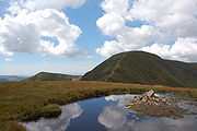 The top of Sail is a heathery dome bearing a small cairn
. The main path along the ridge passes by to the south to take its heavily eroded course up Crag Hill. The view, other than where blocked by this higher neighbour, is excellent. The head of Coledale is laid out to the north while eastward is the full sweep of the Helvellyn range
above Catbells
. The High fells around Ennerdale
, Wasdale
and the head of Eskdale
complete the panorama southward. Bassenthwaite Lake
can be seen from the summit and a few steps will bring Buttermere
and Derwentwater into view.
England
England is a country that is part of the United Kingdom. It shares land borders with Scotland to the north and Wales to the west; the Irish Sea is to the north west, the Celtic Sea to the south west, with the North Sea to the east and the English Channel to the south separating it from continental...
Lake District
Lake District
The Lake District, also commonly known as The Lakes or Lakeland, is a mountainous region in North West England. A popular holiday destination, it is famous not only for its lakes and its mountains but also for its associations with the early 19th century poetry and writings of William Wordsworth...
, lying between Derwentwater and Crummock Water
Crummock Water
Crummock Water is a lake in the Lake District in Cumbria, North West England situated between Buttermere to the south and Loweswater to the north. Crummock Water is two and a half miles long, three quarters of a mile wide and 140ft deep. The River Cocker is considered to start at the north of the...
.
Topography
The North Western FellsNorth Western Fells
The North Western Fells are a group of hills in the English Lake District. Including such favourites as Catbells and Grisedale Pike, they occupy an oval area beneath the Buttermere and Borrowdale valley systems...
occupy the area between the rivers Derwent and Cocker, a broadly oval swathe of hilly country, elongated on a north-south axis. Two roads cross from east to west, dividing the fells into three convenient groups. The central sector, rising between Whinlatter Pass
Whinlatter Pass
The Whinlatter Pass is a mountain pass in the English Lake District. It is located on the B5292 road linking Braithwaite, to the west of Keswick, with High Lorton to the south of Cockermouth....
and Newlands Pass
Newlands Pass
The Newlands Pass, also known as Newlands Hause, is a mountain pass in the English Lake District. It is located on an unclassified road linking the Newlands Valley, to the west of Keswick and Derwent Water, with the village of Buttermere...
, includes Sail. The highest ground in the North Western Fells is an east-west ridge in this central sector, beginning with Grasmoor
Grasmoor
Grasmoor is a mountain in the north-western part of the Lake District, northern England. It is the highest peak in a group of hills between the villages of Lorton, Braithwaite and Buttermere, and overlooks Crummock Water....
above Crummock Water
Crummock Water
Crummock Water is a lake in the Lake District in Cumbria, North West England situated between Buttermere to the south and Loweswater to the north. Crummock Water is two and a half miles long, three quarters of a mile wide and 140ft deep. The River Cocker is considered to start at the north of the...
and then gradually descending eastwards over Crag Hill
Crag Hill
Crag Hill is a mountain in the North Western part of the English Lake District. It was formerly known as Eel Crag; however, the Ordnance Survey now marks Eel Crag as referring to the northern crags of the fell....
, Sail, Scar Crags
Scar Crags
Scar Crags is a fell in the north western part of the English Lake District in the county of Cumbria. It is one of the Coledale group of fells situated seven kilometres south west of Keswick and reaches a height of 672 metres .-Topography:...
and Causey Pike
Causey Pike
Causey Pike is a fell in the English Lake District. It is situated in the Newlands Valley, 5 km south west of the town of Keswick. Even though it has a modest height of 637 metres it is one of the most distinctive fells when viewed from the Derwent Water and Keswick area due to its...
.
Sail is in every sense a satellite of Crag Fell, although having sufficient prominence to be listed as a Hewitt. From the summit of Crag Hill the eastward ridge narrows between opposing walls of crag. This rocky crest is The Scar, the depression being at around 2,425 ft. The roughness decreases as the rounded top of Sail is reached, and the ridge then turns east north east. A further depression at 2,015 ft leads to the summit of Scar Crags. This col is unnamed on maps of the Ordnance Survey
Ordnance Survey
Ordnance Survey , an executive agency and non-ministerial government department of the Government of the United Kingdom, is the national mapping agency for Great Britain, producing maps of Great Britain , and one of the world's largest producers of maps.The name reflects its creation together with...
, but Alfred Wainwright
Alfred Wainwright
Alfred Wainwright MBE was a British fellwalker, guidebook author and illustrator. His seven-volume Pictorial Guide to the Lakeland Fells, published between 1955 and 1966 and consisting entirely of reproductions of his manuscript, has become the standard reference work to 214 of the fells of the...
termed it Sail Pass in his influential Pictorial Guide to the Lakeland Fells
Pictorial Guide to the Lakeland Fells
A Pictorial Guide to the Lakeland Fells is a series of seven books by A. Wainwright, detailing the fells of the Lake District in northwest England...
Sail has a further connection to the south of the main ridge, a high level bridge to Ard Crags
Ard Crags
Ard Crags is a fell in the Lake District in Cumbria, England, it is situated in the Newlands Valley just off the minor road between Keswick and Buttermere...
. Ard Crags and its neighbour, Knott Rigg
Knott Rigg
Knott Rigg is a fell at the head of the Newlands Valley in the English Lake District. It is situated some 8.5 kilometres south west of Keswick and has a modest height of 556 metres . Its name is derived from the Old English language and means “hill on a knobbly ridge”...
, form a lower parallel ridge to the south of the main range.
The main drainage to the north of Sail runs to Coledale
Coledale (Cumbria)
In Cumbria, England, Coledale is a valley in the northwestern region of the Lake District ~-Geography:Coledale is a narrow V shaped river valley running approximately north-east towards the Derwent Valley floodplain and the village of Braithwaite at the northeastern end...
. This is a long uninhabited valley which exits into the floodplain of the Derwent at the village of Braithwaite
Braithwaite
Braithwaite is a village in the northern Lake District, in Cumbria, England. Historically within Cumberland, it lies just to the west of Keswick and to the east of the Grisedale Pike ridge, in the Borough of Allerdale. It forms part of the civil parish of Above Derwent.The eastern end of the...
. Near its head are two successive steps of crag, each bearing a waterfall. The southern flanks of the fell are drained by Sail Beck and its tributaries, flowing south west between the slopes of Wandope
Wandope
Wandope is a fell in the north-western area of the English Lake District. It lies to the east of Crummock Water and south of Crag Hill...
and Knott Rigg to Buttermere
Buttermere
Buttermere is a lake in the English Lake District in North West England. The adjacent village of Buttermere takes its name from the lake. Historically within the former county of Cumberland, the lake is now within the county of Cumbria. It is owned by the National Trust, forming part of their...
village. Sail thus stands on the main watershed of the North Western Fells, a virtue not shared by the higher Grasmoor.
Sail's slopes are steep and rough throughout, with the ridge to Crag Fell being bounded by rock, Scott Crag to the north and Scar Crag to the south. The other principal face is Long Crag which overlooks High Moss and Outerside.
Geology and Mining
The summit areas of Sail are composed of the OrdovicianOrdovician
The Ordovician is a geologic period and system, the second of six of the Paleozoic Era, and covers the time between 488.3±1.7 to 443.7±1.5 million years ago . It follows the Cambrian Period and is followed by the Silurian Period...
Kirkstile Formation. This is the typical rock of the Skiddaw
Skiddaw
Skiddaw is a mountain in the Lake District National Park in England. With a summit at 931 m above sea level it is the fourth highest mountain in England. It lies just north of the town of Keswick, Cumbria, and dominates the skyline in this part of the northern lakes...
fells and is composed of laminated mudstone
Mudstone
Mudstone is a fine grained sedimentary rock whose original constituents were clays or muds. Grain size is up to 0.0625 mm with individual grains too small to be distinguished without a microscope. With increased pressure over time the platey clay minerals may become aligned, with the...
and siltstone
Siltstone
Siltstone is a sedimentary rock which has a grain size in the silt range, finer than sandstone and coarser than claystones.- Description :As its name implies, it is primarily composed of silt sized particles, defined as grains 1/16 - 1/256 mm or 4 to 8 on the Krumbein phi scale...
. Beneath this are the Greywacke
Greywacke
Greywacke or Graywacke is a variety of sandstone generally characterized by its hardness, dark color, and poorly sorted angular grains of quartz, feldspar, and small rock fragments or lithic fragments set in a compact, clay-fine matrix. It is a texturally immature sedimentary rock generally found...
sandstone
Sandstone
Sandstone is a sedimentary rock composed mainly of sand-sized minerals or rock grains.Most sandstone is composed of quartz and/or feldspar because these are the most common minerals in the Earth's crust. Like sand, sandstone may be any colour, but the most common colours are tan, brown, yellow,...
turbities of the Loweswater Formation. The Causey Pike Fault runs across the southern flanks of the fell, beyond which are the rocks of the Buttermere Formation. This is an olistostrome
Olistostrome
The term olistostrome is derived from olio - a dish of many ingredients or stew; a mixture of heterogeneous elements; hodgepodge. and stroma - a bed covering...
of disrupted sheared and folded mudstone, siltstone and sandstone.
On the northern side of Sail Pass are the remains of a cobalt
Cobalt
Cobalt is a chemical element with symbol Co and atomic number 27. It is found naturally only in chemically combined form. The free element, produced by reductive smelting, is a hard, lustrous, silver-gray metal....
mine. The vein runs north-south and, although showing some cobalt, was found to contain a great deal more arsenic
Arsenic
Arsenic is a chemical element with the symbol As, atomic number 33 and relative atomic mass 74.92. Arsenic occurs in many minerals, usually in conjunction with sulfur and metals, and also as a pure elemental crystal. It was first documented by Albertus Magnus in 1250.Arsenic is a metalloid...
. The mine was opened in 1848, after great sums had been spent on a roadway and dressing plant. The total yield of cobalt was only a few ounces and the venture was swiftly abandoned. Several levels can be seen at the surface.
Force Crag mine in Coledale
Coledale (Cumbria)
In Cumbria, England, Coledale is a valley in the northwestern region of the Lake District ~-Geography:Coledale is a narrow V shaped river valley running approximately north-east towards the Derwent Valley floodplain and the village of Braithwaite at the northeastern end...
was a much more successful enterprise, but is properly within the territory of Hopegill Head
Hopegill Head
Hopegill Head is a fell in the English Lake District in Cumbria. It is located nine kilometres west of the town of Keswick and is well seen from the B5292 road which crosses the Whinlatter Pass.-Topography:...
.
Summit and view
Cairn
Cairn is a term used mainly in the English-speaking world for a man-made pile of stones. It comes from the or . Cairns are found all over the world in uplands, on moorland, on mountaintops, near waterways and on sea cliffs, and also in barren desert and tundra areas...
. The main path along the ridge passes by to the south to take its heavily eroded course up Crag Hill. The view, other than where blocked by this higher neighbour, is excellent. The head of Coledale is laid out to the north while eastward is the full sweep of the Helvellyn range
Helvellyn range
Helvellyn range is the name given to a part of the Eastern Fells in the English Lake District, fell being the local word for hill. The name comes from Helvellyn, the highest point of the group....
above Catbells
Catbells
Catbells is a fell in the English Lake District in the county of Cumbria. It has a modest height of but despite this it is one of the most popular fells in the area. It is situated on the western shore of Derwent Water within of the busy tourist town of Keswick...
. The High fells around Ennerdale
Ennerdale
Ennerdale may refer to:* Ennerdale, Gauteng, a suburb of Johannesburg, South Africa* Ennerdale Water, a lake in the Lake District in England**Ennerdale Bridge, a nearby settlement...
, Wasdale
Wasdale
Wasdale is a valley and civil parish in the western part of the Lake District National Park in Cumbria, England. The River Irt flows through the valley to its estuary at Ravenglass. A large part of the main valley floor is occupied by Wastwater, the deepest lake in England...
and the head of Eskdale
Eskdale, Cumbria
Eskdale is a glacial valley and civil parish in the western Lake District National Park in Cumbria, England. It forms part of the Borough of Copeland, and has a population of 264....
complete the panorama southward. Bassenthwaite Lake
Bassenthwaite Lake
Bassenthwaite Lake is one of the largest water bodies in the English Lake District. It is long and narrow, approximately long and wide, but is also extremely shallow, with a maximum depth of about ....
can be seen from the summit and a few steps will bring Buttermere
Buttermere
Buttermere is a lake in the English Lake District in North West England. The adjacent village of Buttermere takes its name from the lake. Historically within the former county of Cumberland, the lake is now within the county of Cumbria. It is owned by the National Trust, forming part of their...
and Derwentwater into view.