
Causey Pike
Encyclopedia
Causey Pike is a fell in the English Lake District
. It is situated in the Newlands Valley
, 5 km south west of the town of Keswick
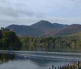
. Even though it has a modest height of 637 metres (2,090 ft) it is one of the most distinctive fells when viewed from the Derwent Water
and Keswick area due to its distinguishing summit "nobble" which catches the eye. The fell is one of 214 fells described by Alfred Wainwright
in his series of Pictorial Guides to the Lakeland Fells: Causey Pike features in Book Six, The North Western Fells.
occupy the area between the rivers Derwent and Cocker, a broadly oval swathe of hilly country, elongated on a north-south axis. Two roads cross from east to west, dividing the fells into three convenient groups. The central sector, rising between Whinlatter Pass
and Newlands Pass
, includes Causey Pike. The highest ground in the North Western Fells is an east-west ridge in this central sector, beginning with Grasmoor
above Crummock Water
and then gradually descending eastwards over Crag Hill
, Sail
, Scar Crags
and Causey Pike.
Causey Pike is separated from Barrow
and Outerside
to the north by Stonycroft Gill. Southward across Rigg Beck is Ard Crags
. Causey Pike has a long blunt ended shoulder running eastward to the Newlands Valley, dropping steeply from its terminus at Rowling End.
and siltstone
of the Kirkstile Formation, usually associated with the Skiddaw
group. The summit knobble is representative of the Buttermere Formation, an olistostrome
of disrupted, sheared and folded mudstone
, siltstone
and sandstone
. Rowling End reveals the large olistoliths of greywacke
sandstone
of the Robinson Member.
, this approaches the fell "from the back" reaching Sail pass and then crossing the summit of Scar Crags before attaining Causey Pike. The fell is also part of the horseshoe walk known as the Coledale Round which is usually started at the village of Braithwaite just west of Keswick (but can also be started in the Newlands Valley) and includes the additional fells of Grisedale Pike
, Hopegill Head
, Grasmoor
, Eel Crag
, Sail and Scar Crags. It is a strenuous 11 mile (18 km) ridge walk with over 4000 feet (1200 m) of ascent.
s: Trilobite
s, Trace fossil
s and Graptolite
s are found on rare occasions. The view from the summit is extensive with Derwentwater
, the Newlands valley, Skiddaw
, Blencathra
and the Helvellyn range
seen very well.
Lake District
The Lake District, also commonly known as The Lakes or Lakeland, is a mountainous region in North West England. A popular holiday destination, it is famous not only for its lakes and its mountains but also for its associations with the early 19th century poetry and writings of William Wordsworth...
. It is situated in the Newlands Valley
Newlands Valley
The Newlands Valley is in the Lake District National Park in Cumbria, England. It is regarded as one of the most picturesque and quiet valleys in the national park, even though it is situated very close to the popular tourist town of Keswick and the busy A66 road.The valley forms part of the civil...
, 5 km south west of the town of Keswick
Keswick, Cumbria
Keswick is a market town and civil parish within the Borough of Allerdale in Cumbria, England. It had a population of 4,984, according to the 2001 census, and is situated just north of Derwent Water, and a short distance from Bassenthwaite Lake, both in the Lake District National Park...
. Even though it has a modest height of 637 metres (2,090 ft) it is one of the most distinctive fells when viewed from the Derwent Water
Derwent Water
Derwentwater is one of the principal bodies of water in the Lake District National Park in north west England. It lies wholly within the Borough of Allerdale, in the county of Cumbria....
and Keswick area due to its distinguishing summit "nobble" which catches the eye. The fell is one of 214 fells described by Alfred Wainwright
Alfred Wainwright
Alfred Wainwright MBE was a British fellwalker, guidebook author and illustrator. His seven-volume Pictorial Guide to the Lakeland Fells, published between 1955 and 1966 and consisting entirely of reproductions of his manuscript, has become the standard reference work to 214 of the fells of the...
in his series of Pictorial Guides to the Lakeland Fells: Causey Pike features in Book Six, The North Western Fells.
Topography
The North Western FellsNorth Western Fells
The North Western Fells are a group of hills in the English Lake District. Including such favourites as Catbells and Grisedale Pike, they occupy an oval area beneath the Buttermere and Borrowdale valley systems...
occupy the area between the rivers Derwent and Cocker, a broadly oval swathe of hilly country, elongated on a north-south axis. Two roads cross from east to west, dividing the fells into three convenient groups. The central sector, rising between Whinlatter Pass
Whinlatter Pass
The Whinlatter Pass is a mountain pass in the English Lake District. It is located on the B5292 road linking Braithwaite, to the west of Keswick, with High Lorton to the south of Cockermouth....
and Newlands Pass
Newlands Pass
The Newlands Pass, also known as Newlands Hause, is a mountain pass in the English Lake District. It is located on an unclassified road linking the Newlands Valley, to the west of Keswick and Derwent Water, with the village of Buttermere...
, includes Causey Pike. The highest ground in the North Western Fells is an east-west ridge in this central sector, beginning with Grasmoor
Grasmoor
Grasmoor is a mountain in the north-western part of the Lake District, northern England. It is the highest peak in a group of hills between the villages of Lorton, Braithwaite and Buttermere, and overlooks Crummock Water....
above Crummock Water
Crummock Water
Crummock Water is a lake in the Lake District in Cumbria, North West England situated between Buttermere to the south and Loweswater to the north. Crummock Water is two and a half miles long, three quarters of a mile wide and 140ft deep. The River Cocker is considered to start at the north of the...
and then gradually descending eastwards over Crag Hill
Crag Hill
Crag Hill is a mountain in the North Western part of the English Lake District. It was formerly known as Eel Crag; however, the Ordnance Survey now marks Eel Crag as referring to the northern crags of the fell....
, Sail
Sail (Lake District)
Sail is a hill in the English Lake District, lying between Derwentwater and Crummock Water.-Topography:The North Western Fells occupy the area between the rivers Derwent and Cocker, a broadly oval swathe of hilly country, elongated on a north-south axis. Two roads cross from east to west, dividing...
, Scar Crags
Scar Crags
Scar Crags is a fell in the north western part of the English Lake District in the county of Cumbria. It is one of the Coledale group of fells situated seven kilometres south west of Keswick and reaches a height of 672 metres .-Topography:...
and Causey Pike.
Causey Pike is separated from Barrow
Barrow (Lake District)
Barrow is small fell in the English Lake District in the county of Cumbria which reaches a height of 455 metres . It is situated in the quiet and picturesque Newlands Valley just 4 kilometres south west of the town of Keswick. Although modest in height, Barrow commands a fine all round...
and Outerside
Outerside
Outerside is a fell in the Lake District in Cumbria, England. It is located 6 kilometres west of Keswick in the north western part of the national park and is a smaller member of the Coledale group of fells with a height of 568 metres...
to the north by Stonycroft Gill. Southward across Rigg Beck is Ard Crags
Ard Crags
Ard Crags is a fell in the Lake District in Cumbria, England, it is situated in the Newlands Valley just off the minor road between Keswick and Buttermere...
. Causey Pike has a long blunt ended shoulder running eastward to the Newlands Valley, dropping steeply from its terminus at Rowling End.
Geology
The ridge is composed of the laminated mudstoneMudstone
Mudstone is a fine grained sedimentary rock whose original constituents were clays or muds. Grain size is up to 0.0625 mm with individual grains too small to be distinguished without a microscope. With increased pressure over time the platey clay minerals may become aligned, with the...
and siltstone
Siltstone
Siltstone is a sedimentary rock which has a grain size in the silt range, finer than sandstone and coarser than claystones.- Description :As its name implies, it is primarily composed of silt sized particles, defined as grains 1/16 - 1/256 mm or 4 to 8 on the Krumbein phi scale...
of the Kirkstile Formation, usually associated with the Skiddaw
Skiddaw
Skiddaw is a mountain in the Lake District National Park in England. With a summit at 931 m above sea level it is the fourth highest mountain in England. It lies just north of the town of Keswick, Cumbria, and dominates the skyline in this part of the northern lakes...
group. The summit knobble is representative of the Buttermere Formation, an olistostrome
Olistostrome
The term olistostrome is derived from olio - a dish of many ingredients or stew; a mixture of heterogeneous elements; hodgepodge. and stroma - a bed covering...
of disrupted, sheared and folded mudstone
Mudstone
Mudstone is a fine grained sedimentary rock whose original constituents were clays or muds. Grain size is up to 0.0625 mm with individual grains too small to be distinguished without a microscope. With increased pressure over time the platey clay minerals may become aligned, with the...
, siltstone
Siltstone
Siltstone is a sedimentary rock which has a grain size in the silt range, finer than sandstone and coarser than claystones.- Description :As its name implies, it is primarily composed of silt sized particles, defined as grains 1/16 - 1/256 mm or 4 to 8 on the Krumbein phi scale...
and sandstone
Sandstone
Sandstone is a sedimentary rock composed mainly of sand-sized minerals or rock grains.Most sandstone is composed of quartz and/or feldspar because these are the most common minerals in the Earth's crust. Like sand, sandstone may be any colour, but the most common colours are tan, brown, yellow,...
. Rowling End reveals the large olistoliths of greywacke
Greywacke
Greywacke or Graywacke is a variety of sandstone generally characterized by its hardness, dark color, and poorly sorted angular grains of quartz, feldspar, and small rock fragments or lithic fragments set in a compact, clay-fine matrix. It is a texturally immature sedimentary rock generally found...
sandstone
Sandstone
Sandstone is a sedimentary rock composed mainly of sand-sized minerals or rock grains.Most sandstone is composed of quartz and/or feldspar because these are the most common minerals in the Earth's crust. Like sand, sandstone may be any colour, but the most common colours are tan, brown, yellow,...
of the Robinson Member.
Ascents
The direct ascent of the fell is usually started from the Newlands valley at Stonycroft where there is some car parking space; this route is steep at the beginning and the end with an easier section in the middle, the final 20 metres of ascent being a rocky scramble. An easier and longer alternative from the same starting point goes by an old track which used to serve the cobalt mine on the slopes of Scar CragsScar Crags
Scar Crags is a fell in the north western part of the English Lake District in the county of Cumbria. It is one of the Coledale group of fells situated seven kilometres south west of Keswick and reaches a height of 672 metres .-Topography:...
, this approaches the fell "from the back" reaching Sail pass and then crossing the summit of Scar Crags before attaining Causey Pike. The fell is also part of the horseshoe walk known as the Coledale Round which is usually started at the village of Braithwaite just west of Keswick (but can also be started in the Newlands Valley) and includes the additional fells of Grisedale Pike
Grisedale Pike
Grisedale Pike is a fell in the Lake District, Cumbria, England situated west of the town of Keswick in the north-western sector of the national park. At a height of 791 m it is the 40th highest Wainwright in the Lake District; it also qualifies as a Hewitt, Marilyn and Nuttall...
, Hopegill Head
Hopegill Head
Hopegill Head is a fell in the English Lake District in Cumbria. It is located nine kilometres west of the town of Keswick and is well seen from the B5292 road which crosses the Whinlatter Pass.-Topography:...
, Grasmoor
Grasmoor
Grasmoor is a mountain in the north-western part of the Lake District, northern England. It is the highest peak in a group of hills between the villages of Lorton, Braithwaite and Buttermere, and overlooks Crummock Water....
, Eel Crag
Crag Hill
Crag Hill is a mountain in the North Western part of the English Lake District. It was formerly known as Eel Crag; however, the Ordnance Survey now marks Eel Crag as referring to the northern crags of the fell....
, Sail and Scar Crags. It is a strenuous 11 mile (18 km) ridge walk with over 4000 feet (1200 m) of ascent.
Summit and View
The summit of the fell is quite unique: it is a narrow ridge with the highest point being on the "nobble" but with four other smaller bumps of almost equal height further on. The scree slopes around the summit have yielded some fossilFossil
Fossils are the preserved remains or traces of animals , plants, and other organisms from the remote past...
s: Trilobite
Trilobite
Trilobites are a well-known fossil group of extinct marine arthropods that form the class Trilobita. The first appearance of trilobites in the fossil record defines the base of the Atdabanian stage of the Early Cambrian period , and they flourished throughout the lower Paleozoic era before...
s, Trace fossil
Trace fossil
Trace fossils, also called ichnofossils , are geological records of biological activity. Trace fossils may be impressions made on the substrate by an organism: for example, burrows, borings , urolites , footprints and feeding marks, and root cavities...
s and Graptolite
Graptolite
Graptolithina is a class in the animal phylum Hemichordata, the members of which are known as Graptolites. Graptolites are fossil colonial animals known chiefly from the Upper Cambrian through the Lower Carboniferous...
s are found on rare occasions. The view from the summit is extensive with Derwentwater
Derwent Water
Derwentwater is one of the principal bodies of water in the Lake District National Park in north west England. It lies wholly within the Borough of Allerdale, in the county of Cumbria....
, the Newlands valley, Skiddaw
Skiddaw
Skiddaw is a mountain in the Lake District National Park in England. With a summit at 931 m above sea level it is the fourth highest mountain in England. It lies just north of the town of Keswick, Cumbria, and dominates the skyline in this part of the northern lakes...
, Blencathra
Blencathra
Blencathra, also known as Saddleback, is one of the most northerly mountains in the English Lake District. It has six separate fell tops, of which the highest is the Hallsfell Top.-Name:...
and the Helvellyn range
Helvellyn range
Helvellyn range is the name given to a part of the Eastern Fells in the English Lake District, fell being the local word for hill. The name comes from Helvellyn, the highest point of the group....
seen very well.