
Plunketts Creek Bridge No. 3
Encyclopedia
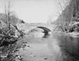
Plunketts Creek Bridge No. 3 was a rubble masonry
stone arch bridge
over Plunketts Creek
in Plunketts Creek Township
, Lycoming County
in the U.S. state
of Pennsylvania
. It was built between 1840 and 1875, probably closer to 1840, when the road along the creek between the unincorporated
villages of Barbours and Proctor was constructed. Going upstream from the mouth, the bridge was the third to cross the creek, hence its name.
The bridge was 75 feet (22.9 m) long, with an arch that spanned 44 feet (13.4 m), a deck 18 in 8 in (5.69 m) wide, and a roadway width of 15 in 3 in (4.65 m). It carried a single lane of traffic; about 450 vehicles a day crossed it in 1996. In the 19th century, the bridge and its road were used by the lumber
, leather
, and coal
industries active along the creek. By the early 20th century, these industries had almost entirely left, and the villages declined. The area the bridge served reverted mostly to second growth forest
and it was used to access Pennsylvania State Game Lands
and a state pheasant
farm.
Plunketts Creek Bridge No. 3 was considered "significant as an intact example of mid-19th century stone arch bridge construction", and was added to the National Register of Historic Places
(NRHP) on June 22, 1988. Although it was repaired after a major flood in 1918, a record flood on January 21, 1996, severely damaged the bridge, and it was demolished in March 1996. Later that same year, a replacement bridge was built and the old stone structure was documented by the Historic American Engineering Record
. It was removed from the NRHP on July 22, 2002.
drainage basin
, the earliest recorded inhabitants of which were the Susquehannock
s. Their numbers were greatly reduced by disease and warfare with the Five Nations of the Iroquois
, and by 1675 they had died out, moved away, or been assimilated into other tribes. The West Branch Susquehanna River valley was subsequently under the nominal control of the Iroquois,Note: For a general overview of Native American History in the West Branch Susquehanna watershed, see Retrieved on September 30, 2008. Note: ISBN refers to the Heritage Books July 1996 reprint. URL is to a scan of the 1892 version with some OCR
typos. who invited displaced tribes, including the Lenape
(Delaware) and Shawnee
to live in the lands vacated by the Susquehannocks. However, the French and Indian War
(1754–1763) led to the migration of many Native Americans
westward to the Ohio River basin. On November 5, 1768, the British
acquired the New Purchase from the Iroquois in the Treaty of Fort Stanwix
, including what is now Plunketts Creek. The first settlement along the creek by European colonists took place between 1770 and 1776.
Plunketts Creek is named for Colonel
William Plunkett, a physician
, who was the first president judge
of Northumberland County
after it was formed in 1772. During conflicts with Native Americans, he treated wounded settlers
and fought the natives. Plunkett led a Pennsylvania expedition in the Pennamite-Yankee War
to forcibly remove settlers from Connecticut
, who had claimed and settled on lands in the Wyoming Valley
also claimed by Pennsylvania. For his services, Plunkett was granted six tracts of land that totaled 1978 acres (800.5 ha) on November 14, 1776, although the land was not actually surveyed until September 1783. Plunkett's land included the creek's mouth
, so Plunketts Creek was given his name. He died in 1791, aged about 100, and was buried in Northumberland
without a grave marker or monument (except for the creek that bears his name).
Lycoming County was formed from Northumberland County in 1795. When Plunketts Creek Township
was formed in Lycoming County in 1838, the original name proposed was "Plunkett Township"; however, Plunkett's lack of active support for the American Revolution
some years earlier had led some to believe his loyalty lay with the British Empire
. The lingering suspicion of his loyalist
sympathies led to the proposed name being rejected. Naming the township for the creek rather than its namesake was seen as an acceptable compromise.
on Loyalsock Creek near the mouth of Plunketts Creek. This developed into the village of Barbours Mills, today known as Barbours. In the 19th century, Barbours had several blacksmith
s, a temperance
hotel, post office
, many sawmills, a school, store and wagon maker. In 1840, a road was built north from Barbours along Plunketts Creek, crossing it several times. This is the earliest possible date for construction of the bridge, but the surviving county road docket on the construction mentions neither bridges nor fords for crossing the creek.
The bridge is at the mouth of Coal Mine Hollow, and the road it was on was used by the lumber
and coal
industries that were active in Plunketts Creek Township during the 19th and early 20th centuries. Creeks in the township supplied water power
to 14 mills in 1861, and by 1876 there were 19 sawmills, a shingle
mill, a wool
en factory, and a tannery
. By the latter half of the 19th century, these industries supported the inhabitants of two villages in Plunketts Creek Township.
In 1868 the village of Proctorville was founded as a company town
for Thomas E. Proctor's tannery, which was completed in 1873. Proctor, as it is now known, is 1.66 miles (2.7 km) north of Barbours along Plunketts Creek, and the main road to it crossed the bridge. The bark from Eastern hemlock trees was used in the tanning process, and the village originally sat in the midst of vast forests of hemlock. The tannery employed "several hundred" workers at wages between 50 cents and $1.75 a day. These employees lived in 120 company houses, which each cost $2 a month to rent. In 1892, Proctor had a barber shop, two blacksmiths, cigar stand, Independent Order of Odd Fellows
hall, leather shop, news stand, a post office (established in 1885), a two-room school, two stores, and a wagon shop.
The road between Barbours and Proctor crosses Plunketts Creek four times and the four bridges are numbered in order, starting from the southernmost in Barbours near the mouth and going upstream. While evidence such as maps indicates that the third bridge was constructed close to 1840, the first definitive proof of its existence is a survey to relocate the road between the second and third bridges in 1875. The first bridge over Plunketts Creek was replaced with a covered bridge
in 1880, and the second bridge was replaced in 1886. That same year, the road between the second and third bridges was moved again, returning to its original position on the west side of the creek.
Finished sole leather was hauled over the bridge by horse-drawn wagon south about 8 miles (12.9 km) to Little Bear Creek, where it was exchanged for "green" hides
and other supplies brought north from Montoursville
. These were then hauled north across the bridge into Proctor. The hides, which were tanned to make leather, came from the United States, and as far away as Mexico
, Argentina
, and China
. Hemlock bark, used in the tanning process, was hauled to the tannery from up to 8 miles (12.9 km) away in both summer and winter, using wagons and sleds. The lumber boom on Plunketts Creek ended when the virgin timber ran out. By 1898, the old growth hemlock
was exhausted and the Proctor tannery, then owned by the Elk Tanning Company, was closed and dismantled.
Without timber and the tannery, the populations of Proctor and Barbours declined, as did traffic on the road and bridges between them. The Barbours post office closed in the 1930s and the Proctor post office closed on July 1, 1953. Both villages also lost their schools and almost all of their businesses. Proctor celebrated its centennial in 1968, and a 1970 newspaper article on its 39th annual "Proctor Homecoming" reunion called it a "near-deserted old tannery town". In the 1980s, the last store in Barbours closed, and the former hotel (which had become a hunting club) was torn down to make way for a new bridge across Loyalsock Creek.
Plunketts Creek has been a place for lumber and tourism since its villages were founded, and as industry declined, nature recovered. Second growth forests
have since covered most of the clear-cut land. Pennsylvania's state legislature authorized the acquisition of abandoned and clear-cut land for Pennsylvania State Game Lands
in 1919, and the Pennsylvania Game Commission
(PGC) acquired property along Plunketts Creek for State Game Lands Number 134 between 1937 and 1945. The main entrance to State Game Lands 134 is just north of the bridge site, on the east side of the creek.
The PGC established the Northcentral State Game Farm in 1945 on part of State Game Lands 134 to raise wild turkey. The farm was converted to ringneck pheasant
production in 1981, and, as of 2007, it was one of four Pennsylvania state game farms that produced about 200,000 pheasants each year for release on land open to public hunting. The Northcentral State Game Farm is chiefly in the Plunketts Creek valley, just south of Proctor and north of the bridge. The opening weekend of the trout season brings more people into the village of Barbours at the mouth of Plunketts Creek than any other time of the year.
On June 22, 1988, the bridge was added to the National Register of Historic Places
(NRHP), as part of the Multiple Property Submission (MPS) of Highway Bridges Owned by the Commonwealth of Pennsylvania, Department of Transportation, TR. The MPS included 135 bridges owned by the Pennsylvania Department of Transportation
(PennDOT), 58 of which were of the stone arch type. While the individual NRHP form for the bridge cites a 1932 inspection report (the year that the state took over its maintenance), the MPS form mistakenly gives the bridge's date of construction as 1932.
on January 6–8 produced up to 40 inches (101.6 cm) of snow, which was followed on January 19–21 by more than 3 inches (76.2 mm) of rain with temperatures as high as 62 °F (16.7 °C) and winds up to 38 miles per hour (17 m/s). The rain and snowmelt caused flooding throughout Pennsylvania and ice jams
made this worse on many streams. Elsewhere in Lycoming County, flooding on Lycoming Creek
in and near Williamsport
killed six people and caused millions of dollars in damage.
On Plunketts Creek, ice jams led to record flooding, which caused irreparable major damage to the mid-19th century stone arch bridge. Downstream in Barbours, the waters were 4 feet (1.2 m) deep in the village's "worst flood in history". Plunketts Creek Bridge No. 3 was one of two destroyed in Lycoming County, and on January 31 a photograph of the damaged bridge was featured on the front page of the Williamsport Sun-Gazette with the caption "This old stone arch bridge over Plunketts Creek must be replaced." In neighboring Sullivan County
, the Sonestown Covered Bridge
, also on the NRHP, was so damaged by the flood that it remained closed for repairs until late December 1996. Throughout Pennsylvania, these floods led to 20 deaths and 69 municipal- or state-owned bridges being either "destroyed or closed until inspections could verify their safety".
When it became clear that the bridge could not be repaired, PennDOT awarded an emergency contract for a temporary bridge before the end of January, citing "emergency vehicles that can no longer travel directly from Barbours" to Proctor and beyond. The temporary bridge cost $87,000 and was 24 feet (7.3 m) wide. The photographs for the bridge's inclusion in the Historic American Engineering Record
(HAER) were taken in January, and the HAER "documentation package was prepared as mitigation for the emergency demolition" of the bridge, which was collapsed in March. The permanent replacement bridge was completed in 1996, and the bridge was removed from the NRHP on July 22, 2002.
stone arch bridge
, oriented roughly east–west over Plunketts Creek. Its overall length was 75 feet (22.9 m) and its single semi-circular arch spanned 44 feet (13.4 m). The bridge deck width was 18 in 8 in (5.69 m), and its roadway was 15 in 3 in (4.65 m) wide, which could accommodate only a single lane of traffic. Just before the flood that led to the bridge's destruction, about 450 vehicles crossed the bridge daily. The outside corners of the wing wall
s were 25 feet (7.6 m) apart, which combined with the overall length of 75 feet (22.9 m) led to a total area of 1875 square feet (174.2 m²) being listed on the NRHP.
The bridge rested on abutment
s which had been jacketed with concrete some time after its original construction. The arch was supported by voussoir
s made of "irregular rubble stone", without a keystone
. There was also no stone giving the date or other construction information. The approaches were flanked by wing walls constructed of riprap
stones, and the spandrel
walls were topped by parapet
s made of "rough, crenellated stones". The bridge's road deck rested directly on the top of its arch. This led to a "narrow wall at the arch crown" and a "protruding rock parapet" atop this spandrel wall on either side. Most stone arch bridges have solid parapets without decoration; this bridge's parapet crenellation was an ornamental feature. The parapet construction and appearance made the bridge unique among the 58 Pennsylvania stone arch bridges with which it was nominated for the NRHP.
Pennsylvania has a long history of stone arch bridges, including the oldest such bridge in use in the United States, the 1697 Frankford Avenue Bridge
over Pennypack Creek
in Philadelphia. Such bridges typically used local stone, with three types of finishing possible. Rubble or third-class masonry construction used stones just as they came from the quarry; squared-stone or second-class masonry used stones that had been roughly dressed and squared; and ashlar
or first-class masonry used stones which had been finely dressed and carefully squared. Rubble masonry was the quickest and cheapest for construction, and had the largest tolerances. Many of the oldest stone bridges in Pennsylvania were built using rubble masonry techniques.
Stone bridge construction started with the excavation of foundations for the abutments. Then a temporary structure known as a center or centering would be built of wood or iron. This structure supported the stone arch during construction. Once the stone arch was built, the spandrel walls and wing walls could be added. Then the road bed was built, with fill (loose stones or dirt) added to support it as needed. Wall and arch stones were generally set in place dry to ensure a good fit, then set in mortar
. Once the bridge was complete and the mortar had properly hardened, the center was gradually lowered and then removed. In March 1996, after standing for between 156 and 121 years, the arch of Bridge No. 3 finally collapsed.
Rubble masonry
Rubble masonry is rough, unhewn building stone set in mortar, but not laid in regular courses. It may appear as the outer surface of a wall or may fill the core of a wall which is faced with unit masonry such as brick or cut stone....
stone arch bridge
Arch bridge
An arch bridge is a bridge with abutments at each end shaped as a curved arch. Arch bridges work by transferring the weight of the bridge and its loads partially into a horizontal thrust restrained by the abutments at either side...
over Plunketts Creek
Plunketts Creek (Loyalsock Creek)
Plunketts Creek is an approximately tributary of Loyalsock Creek in Lycoming and Sullivan counties in the U.S. state of Pennsylvania. Two unincorporated villages and a hamlet are on the creek, and its watershed drains in parts of five townships...
in Plunketts Creek Township
Plunketts Creek Township, Pennsylvania
Plunketts Creek Township is a township in Lycoming County, Pennsylvania, in the United States. It includes the villages of Barbours and Proctor. The population was 771 at the 2000 census...
, Lycoming County
Lycoming County, Pennsylvania
-Appalachian Mountains and Allegheny Plateau:Lycoming County is divided between the Appalachian Mountains in the south, the dissected Allegheny Plateau in the north and east, and the valley of the West Branch Susquehanna River between these.-West Branch Susquehanna River:The West Branch of the...
in the U.S. state
U.S. state
A U.S. state is any one of the 50 federated states of the United States of America that share sovereignty with the federal government. Because of this shared sovereignty, an American is a citizen both of the federal entity and of his or her state of domicile. Four states use the official title of...
of Pennsylvania
Pennsylvania
The Commonwealth of Pennsylvania is a U.S. state that is located in the Northeastern and Mid-Atlantic regions of the United States. The state borders Delaware and Maryland to the south, West Virginia to the southwest, Ohio to the west, New York and Ontario, Canada, to the north, and New Jersey to...
. It was built between 1840 and 1875, probably closer to 1840, when the road along the creek between the unincorporated
Unincorporated area
In law, an unincorporated area is a region of land that is not a part of any municipality.To "incorporate" in this context means to form a municipal corporation, a city, town, or village with its own government. An unincorporated community is usually not subject to or taxed by a municipal government...
villages of Barbours and Proctor was constructed. Going upstream from the mouth, the bridge was the third to cross the creek, hence its name.
The bridge was 75 feet (22.9 m) long, with an arch that spanned 44 feet (13.4 m), a deck 18 in 8 in (5.69 m) wide, and a roadway width of 15 in 3 in (4.65 m). It carried a single lane of traffic; about 450 vehicles a day crossed it in 1996. In the 19th century, the bridge and its road were used by the lumber
Logging
Logging is the cutting, skidding, on-site processing, and loading of trees or logs onto trucks.In forestry, the term logging is sometimes used in a narrow sense concerning the logistics of moving wood from the stump to somewhere outside the forest, usually a sawmill or a lumber yard...
, leather
Tanning
Tanning is the making of leather from the skins of animals which does not easily decompose. Traditionally, tanning used tannin, an acidic chemical compound from which the tanning process draws its name . Coloring may occur during tanning...
, and coal
Bituminous coal
Bituminous coal or black coal is a relatively soft coal containing a tarlike substance called bitumen. It is of higher quality than lignite coal but of poorer quality than Anthracite...
industries active along the creek. By the early 20th century, these industries had almost entirely left, and the villages declined. The area the bridge served reverted mostly to second growth forest
Secondary forest
A secondary forest is a forest or woodland area which has re-grown after a major disturbance such as fire, insect infestation, timber harvest or windthrow, until a long enough period has passed so that the effects of the disturbance are no longer evident...
and it was used to access Pennsylvania State Game Lands
Pennsylvania State Game Lands
The Pennsylvania State Game Lands are lands managed by the Pennsylvania Game Commission for hunting, trapping, and fishing. These lands, often not usable for farming or development, are donated to the PGC or purchased by the PGC with hunting license monies.The Pennsylvania Game Commission runs a...
and a state pheasant
Common Pheasant
The Common Pheasant , is a bird in the pheasant family . It is native to Georgia and has been widely introduced elsewhere as a game bird. In parts of its range, namely in places where none of its relatives occur such as in Europe , it is simply known as the "pheasant"...
farm.
Plunketts Creek Bridge No. 3 was considered "significant as an intact example of mid-19th century stone arch bridge construction", and was added to the National Register of Historic Places
National Register of Historic Places
The National Register of Historic Places is the United States government's official list of districts, sites, buildings, structures, and objects deemed worthy of preservation...
(NRHP) on June 22, 1988. Although it was repaired after a major flood in 1918, a record flood on January 21, 1996, severely damaged the bridge, and it was demolished in March 1996. Later that same year, a replacement bridge was built and the old stone structure was documented by the Historic American Engineering Record
Historic American Buildings Survey
The Historic American Buildings Survey , Historic American Engineering Record , and Historic American Landscapes Survey are programs of the National Park Service established for the purpose of documenting historic places. Records consists of measured drawings, archival photographs, and written...
. It was removed from the NRHP on July 22, 2002.
Early inhabitants and name
Plunketts Creek is in the West Branch Susquehanna RiverWest Branch Susquehanna River
The West Branch Susquehanna River is one of the two principal branches, along with the North Branch, of the Susquehanna River in the northeastern United States. The North Branch, which rises in upstate New York, is generally regarded as the extension of the main branch, with the shorter West Branch...
drainage basin
Drainage basin
A drainage basin is an extent or an area of land where surface water from rain and melting snow or ice converges to a single point, usually the exit of the basin, where the waters join another waterbody, such as a river, lake, reservoir, estuary, wetland, sea, or ocean...
, the earliest recorded inhabitants of which were the Susquehannock
Susquehannock
The Susquehannock people were Iroquoian-speaking Native Americans who lived in areas adjacent to the Susquehanna River and its tributaries from the southern part of what is now New York, through Pennsylvania, to the mouth of the Susquehanna in Maryland at the north end of the Chesapeake Bay...
s. Their numbers were greatly reduced by disease and warfare with the Five Nations of the Iroquois
Iroquois
The Iroquois , also known as the Haudenosaunee or the "People of the Longhouse", are an association of several tribes of indigenous people of North America...
, and by 1675 they had died out, moved away, or been assimilated into other tribes. The West Branch Susquehanna River valley was subsequently under the nominal control of the Iroquois,Note: For a general overview of Native American History in the West Branch Susquehanna watershed, see Retrieved on September 30, 2008. Note: ISBN refers to the Heritage Books July 1996 reprint. URL is to a scan of the 1892 version with some OCR
Optical character recognition
Optical character recognition, usually abbreviated to OCR, is the mechanical or electronic translation of scanned images of handwritten, typewritten or printed text into machine-encoded text. It is widely used to convert books and documents into electronic files, to computerize a record-keeping...
typos. who invited displaced tribes, including the Lenape
Lenape
The Lenape are an Algonquian group of Native Americans of the Northeastern Woodlands. They are also called Delaware Indians. As a result of the American Revolutionary War and later Indian removals from the eastern United States, today the main groups live in Canada, where they are enrolled in the...
(Delaware) and Shawnee
Shawnee
The Shawnee, Shaawanwaki, Shaawanooki and Shaawanowi lenaweeki, are an Algonquian-speaking people native to North America. Historically they inhabited the areas of Ohio, Virginia, West Virginia, Western Maryland, Kentucky, Indiana, and Pennsylvania...
to live in the lands vacated by the Susquehannocks. However, the French and Indian War
French and Indian War
The French and Indian War is the common American name for the war between Great Britain and France in North America from 1754 to 1763. In 1756, the war erupted into the world-wide conflict known as the Seven Years' War and thus came to be regarded as the North American theater of that war...
(1754–1763) led to the migration of many Native Americans
Native Americans in the United States
Native Americans in the United States are the indigenous peoples in North America within the boundaries of the present-day continental United States, parts of Alaska, and the island state of Hawaii. They are composed of numerous, distinct tribes, states, and ethnic groups, many of which survive as...
westward to the Ohio River basin. On November 5, 1768, the British
British Empire
The British Empire comprised the dominions, colonies, protectorates, mandates and other territories ruled or administered by the United Kingdom. It originated with the overseas colonies and trading posts established by England in the late 16th and early 17th centuries. At its height, it was the...
acquired the New Purchase from the Iroquois in the Treaty of Fort Stanwix
Treaty of Fort Stanwix
The Treaty of Fort Stanwix was an important treaty between North American Indians and the British Empire. It was signed in 1768 at Fort Stanwix, located in present-day Rome, New York...
, including what is now Plunketts Creek. The first settlement along the creek by European colonists took place between 1770 and 1776.
Plunketts Creek is named for Colonel
Colonel
Colonel , abbreviated Col or COL, is a military rank of a senior commissioned officer. It or a corresponding rank exists in most armies and in many air forces; the naval equivalent rank is generally "Captain". It is also used in some police forces and other paramilitary rank structures...
William Plunkett, a physician
Physician
A physician is a health care provider who practices the profession of medicine, which is concerned with promoting, maintaining or restoring human health through the study, diagnosis, and treatment of disease, injury and other physical and mental impairments...
, who was the first president judge
Chief Justice
The Chief Justice in many countries is the name for the presiding member of a Supreme Court in Commonwealth or other countries with an Anglo-Saxon justice system based on English common law, such as the Supreme Court of Canada, the Constitutional Court of South Africa, the Court of Final Appeal of...
of Northumberland County
Northumberland County, Pennsylvania
There were 38,835 households out of which 27.30% had children under the age of 18 living with them, 52.40% were married couples living together, 9.60% had a female householder with no husband present, and 34.10% were non-families. 30.20% of all households were made up of individuals and 15.50% had...
after it was formed in 1772. During conflicts with Native Americans, he treated wounded settlers
American pioneer
American pioneers are any of the people in American history who migrated west to join in settling and developing new areas. The term especially refers to those who were going to settle any territory which had previously not been settled or developed by European or American society, although the...
and fought the natives. Plunkett led a Pennsylvania expedition in the Pennamite-Yankee War
Pennamite-Yankee War
The Pennamite-Yankee War was the intermittent conflict between 1769 and 1799 between settlers from Connecticut who claimed the land along the North Branch of the Susquehanna River in the present Wyoming Valley, and settlers from Pennsylvania who laid claim to the same lands.-Grants to Connecticut...
to forcibly remove settlers from Connecticut
Connecticut
Connecticut is a state in the New England region of the northeastern United States. It is bordered by Rhode Island to the east, Massachusetts to the north, and the state of New York to the west and the south .Connecticut is named for the Connecticut River, the major U.S. river that approximately...
, who had claimed and settled on lands in the Wyoming Valley
Wyoming Valley
Wyoming Valley is a region of northeastern Pennsylvania. As a metropolitan area, it is also known as the Scranton/Wilkes-Barre area, after its principal cities, Scranton and Wilkes-Barre....
also claimed by Pennsylvania. For his services, Plunkett was granted six tracts of land that totaled 1978 acres (800.5 ha) on November 14, 1776, although the land was not actually surveyed until September 1783. Plunkett's land included the creek's mouth
River delta
A delta is a landform that is formed at the mouth of a river where that river flows into an ocean, sea, estuary, lake, reservoir, flat arid area, or another river. Deltas are formed from the deposition of the sediment carried by the river as the flow leaves the mouth of the river...
, so Plunketts Creek was given his name. He died in 1791, aged about 100, and was buried in Northumberland
Northumberland, Pennsylvania
Northumberland is a borough in Northumberland County, Pennsylvania, United States. The population was 3,714 at the 2000 census.-History:Northumberland was founded in 1772. The land that became Northumberland was purchased from the Iroquois in the first Treaty of Fort Stanwix in 1768, and the...
without a grave marker or monument (except for the creek that bears his name).
Lycoming County was formed from Northumberland County in 1795. When Plunketts Creek Township
Plunketts Creek Township, Pennsylvania
Plunketts Creek Township is a township in Lycoming County, Pennsylvania, in the United States. It includes the villages of Barbours and Proctor. The population was 771 at the 2000 census...
was formed in Lycoming County in 1838, the original name proposed was "Plunkett Township"; however, Plunkett's lack of active support for the American Revolution
American Revolution
The American Revolution was the political upheaval during the last half of the 18th century in which thirteen colonies in North America joined together to break free from the British Empire, combining to become the United States of America...
some years earlier had led some to believe his loyalty lay with the British Empire
British Empire
The British Empire comprised the dominions, colonies, protectorates, mandates and other territories ruled or administered by the United Kingdom. It originated with the overseas colonies and trading posts established by England in the late 16th and early 17th centuries. At its height, it was the...
. The lingering suspicion of his loyalist
Loyalist (American Revolution)
Loyalists were American colonists who remained loyal to the Kingdom of Great Britain during the American Revolutionary War. At the time they were often called Tories, Royalists, or King's Men. They were opposed by the Patriots, those who supported the revolution...
sympathies led to the proposed name being rejected. Naming the township for the creek rather than its namesake was seen as an acceptable compromise.
Villages and road
In 1832, John Barbour built a sawmillSawmill
A sawmill is a facility where logs are cut into boards.-Sawmill process:A sawmill's basic operation is much like those of hundreds of years ago; a log enters on one end and dimensional lumber exits on the other end....
on Loyalsock Creek near the mouth of Plunketts Creek. This developed into the village of Barbours Mills, today known as Barbours. In the 19th century, Barbours had several blacksmith
Blacksmith
A blacksmith is a person who creates objects from wrought iron or steel by forging the metal; that is, by using tools to hammer, bend, and cut...
s, a temperance
Temperance movement
A temperance movement is a social movement urging reduced use of alcoholic beverages. Temperance movements may criticize excessive alcohol use, promote complete abstinence , or pressure the government to enact anti-alcohol legislation or complete prohibition of alcohol.-Temperance movement by...
hotel, post office
Post office
A post office is a facility forming part of a postal system for the posting, receipt, sorting, handling, transmission or delivery of mail.Post offices offer mail-related services such as post office boxes, postage and packaging supplies...
, many sawmills, a school, store and wagon maker. In 1840, a road was built north from Barbours along Plunketts Creek, crossing it several times. This is the earliest possible date for construction of the bridge, but the surviving county road docket on the construction mentions neither bridges nor fords for crossing the creek.
The bridge is at the mouth of Coal Mine Hollow, and the road it was on was used by the lumber
Logging
Logging is the cutting, skidding, on-site processing, and loading of trees or logs onto trucks.In forestry, the term logging is sometimes used in a narrow sense concerning the logistics of moving wood from the stump to somewhere outside the forest, usually a sawmill or a lumber yard...
and coal
Bituminous coal
Bituminous coal or black coal is a relatively soft coal containing a tarlike substance called bitumen. It is of higher quality than lignite coal but of poorer quality than Anthracite...
industries that were active in Plunketts Creek Township during the 19th and early 20th centuries. Creeks in the township supplied water power
Hydropower
Hydropower, hydraulic power, hydrokinetic power or water power is power that is derived from the force or energy of falling water, which may be harnessed for useful purposes. Since ancient times, hydropower has been used for irrigation and the operation of various mechanical devices, such as...
to 14 mills in 1861, and by 1876 there were 19 sawmills, a shingle
Shake (shingle)
A shake is a basic wooden shingle that is made from split logs. Shakes have traditionally been used for roofing and siding applications around the world. Higher grade shakes are typically used for roofing purposes, while the lower grades are used for siding purposes...
mill, a wool
Wool
Wool is the textile fiber obtained from sheep and certain other animals, including cashmere from goats, mohair from goats, qiviut from muskoxen, vicuña, alpaca, camel from animals in the camel family, and angora from rabbits....
en factory, and a tannery
Tanning
Tanning is the making of leather from the skins of animals which does not easily decompose. Traditionally, tanning used tannin, an acidic chemical compound from which the tanning process draws its name . Coloring may occur during tanning...
. By the latter half of the 19th century, these industries supported the inhabitants of two villages in Plunketts Creek Township.
In 1868 the village of Proctorville was founded as a company town
Company town
A company town is a town or city in which much or all real estate, buildings , utilities, hospitals, small businesses such as grocery stores and gas stations, and other necessities or luxuries of life within its borders are owned by a single company...
for Thomas E. Proctor's tannery, which was completed in 1873. Proctor, as it is now known, is 1.66 miles (2.7 km) north of Barbours along Plunketts Creek, and the main road to it crossed the bridge. The bark from Eastern hemlock trees was used in the tanning process, and the village originally sat in the midst of vast forests of hemlock. The tannery employed "several hundred" workers at wages between 50 cents and $1.75 a day. These employees lived in 120 company houses, which each cost $2 a month to rent. In 1892, Proctor had a barber shop, two blacksmiths, cigar stand, Independent Order of Odd Fellows
Independent Order of Odd Fellows
The Independent Order of Odd Fellows , also known as the Three Link Fraternity, is an altruistic and benevolent fraternal organization derived from the similar British Oddfellows service organizations which came into being during the 18th century, at a time when altruistic and charitable acts were...
hall, leather shop, news stand, a post office (established in 1885), a two-room school, two stores, and a wagon shop.
The road between Barbours and Proctor crosses Plunketts Creek four times and the four bridges are numbered in order, starting from the southernmost in Barbours near the mouth and going upstream. While evidence such as maps indicates that the third bridge was constructed close to 1840, the first definitive proof of its existence is a survey to relocate the road between the second and third bridges in 1875. The first bridge over Plunketts Creek was replaced with a covered bridge
Covered bridge
A covered bridge is a bridge with enclosed sides and a roof, often accommodating only a single lane of traffic. Most covered bridges are wooden; some newer ones are concrete or metal with glass sides...
in 1880, and the second bridge was replaced in 1886. That same year, the road between the second and third bridges was moved again, returning to its original position on the west side of the creek.
Finished sole leather was hauled over the bridge by horse-drawn wagon south about 8 miles (12.9 km) to Little Bear Creek, where it was exchanged for "green" hides
Hides
A hide is an animal skin treated for human use. Hides include leather from cattle and other livestock animals, alligator skins, snake skins for shoes and fashion accessories and furs from wild cats, mink and bears. In some areas, leather is produced on a domestic or small industrial scale, but most...
and other supplies brought north from Montoursville
Montoursville, Pennsylvania
Montoursville is a borough in Lycoming County, Pennsylvania, in the United States. As of the 2000 census, the borough population was 4,777. It is part of the Williamsport, Pennsylvania Metropolitan Statistical Area. It was named for Madame Montour, a Native American leader and skilled interpreter...
. These were then hauled north across the bridge into Proctor. The hides, which were tanned to make leather, came from the United States, and as far away as Mexico
Mexico
The United Mexican States , commonly known as Mexico , is a federal constitutional republic in North America. It is bordered on the north by the United States; on the south and west by the Pacific Ocean; on the southeast by Guatemala, Belize, and the Caribbean Sea; and on the east by the Gulf of...
, Argentina
Argentina
Argentina , officially the Argentine Republic , is the second largest country in South America by land area, after Brazil. It is constituted as a federation of 23 provinces and an autonomous city, Buenos Aires...
, and China
China
Chinese civilization may refer to:* China for more general discussion of the country.* Chinese culture* Greater China, the transnational community of ethnic Chinese.* History of China* Sinosphere, the area historically affected by Chinese culture...
. Hemlock bark, used in the tanning process, was hauled to the tannery from up to 8 miles (12.9 km) away in both summer and winter, using wagons and sleds. The lumber boom on Plunketts Creek ended when the virgin timber ran out. By 1898, the old growth hemlock
Old growth forest
An old-growth forest is a forest that has attained great age , and thereby exhibits unique ecological features. An old growth forest has also usually reached a climax community...
was exhausted and the Proctor tannery, then owned by the Elk Tanning Company, was closed and dismantled.
20th century
Small-scale lumbering continued in the watershed in the 20th century, but the last logs were floated under the bridge down Plunketts Creek to Loyalsock Creek in 1905. In 1918, a flood on the creek damaged the road for 100 feet (30.5 m) on both sides of the bridge, and caused "settling and cracking of the bridge itself". The bridge had needed repairs and reconstruction. In 1931, the Commonwealth of Pennsylvania passed legislation that gave the state responsibility for the costs of road and bridge maintenance for many highways belonging to local municipalities. This took effect in 1932, relieving Plunketts Creek Township and Lycoming County of the responsibility.Without timber and the tannery, the populations of Proctor and Barbours declined, as did traffic on the road and bridges between them. The Barbours post office closed in the 1930s and the Proctor post office closed on July 1, 1953. Both villages also lost their schools and almost all of their businesses. Proctor celebrated its centennial in 1968, and a 1970 newspaper article on its 39th annual "Proctor Homecoming" reunion called it a "near-deserted old tannery town". In the 1980s, the last store in Barbours closed, and the former hotel (which had become a hunting club) was torn down to make way for a new bridge across Loyalsock Creek.
Plunketts Creek has been a place for lumber and tourism since its villages were founded, and as industry declined, nature recovered. Second growth forests
Secondary forest
A secondary forest is a forest or woodland area which has re-grown after a major disturbance such as fire, insect infestation, timber harvest or windthrow, until a long enough period has passed so that the effects of the disturbance are no longer evident...
have since covered most of the clear-cut land. Pennsylvania's state legislature authorized the acquisition of abandoned and clear-cut land for Pennsylvania State Game Lands
Pennsylvania State Game Lands
The Pennsylvania State Game Lands are lands managed by the Pennsylvania Game Commission for hunting, trapping, and fishing. These lands, often not usable for farming or development, are donated to the PGC or purchased by the PGC with hunting license monies.The Pennsylvania Game Commission runs a...
in 1919, and the Pennsylvania Game Commission
Pennsylvania Game Commission
The Pennsylvania Game Commission is the state agency responsible for wildlife conservation and management in Pennsylvania in the United States...
(PGC) acquired property along Plunketts Creek for State Game Lands Number 134 between 1937 and 1945. The main entrance to State Game Lands 134 is just north of the bridge site, on the east side of the creek.
The PGC established the Northcentral State Game Farm in 1945 on part of State Game Lands 134 to raise wild turkey. The farm was converted to ringneck pheasant
Common Pheasant
The Common Pheasant , is a bird in the pheasant family . It is native to Georgia and has been widely introduced elsewhere as a game bird. In parts of its range, namely in places where none of its relatives occur such as in Europe , it is simply known as the "pheasant"...
production in 1981, and, as of 2007, it was one of four Pennsylvania state game farms that produced about 200,000 pheasants each year for release on land open to public hunting. The Northcentral State Game Farm is chiefly in the Plunketts Creek valley, just south of Proctor and north of the bridge. The opening weekend of the trout season brings more people into the village of Barbours at the mouth of Plunketts Creek than any other time of the year.
On June 22, 1988, the bridge was added to the National Register of Historic Places
National Register of Historic Places
The National Register of Historic Places is the United States government's official list of districts, sites, buildings, structures, and objects deemed worthy of preservation...
(NRHP), as part of the Multiple Property Submission (MPS) of Highway Bridges Owned by the Commonwealth of Pennsylvania, Department of Transportation, TR. The MPS included 135 bridges owned by the Pennsylvania Department of Transportation
Pennsylvania Department of Transportation
The Pennsylvania Department of Transportation oversees transportation issues in the Commonwealth of Pennsylvania. The administrator of PennDOT is the Pennsylvania Secretary of Transportation, currently Barry Schoch Presently, PennDOT supports over of state roads and highways, about 25,000...
(PennDOT), 58 of which were of the stone arch type. While the individual NRHP form for the bridge cites a 1932 inspection report (the year that the state took over its maintenance), the MPS form mistakenly gives the bridge's date of construction as 1932.
Flood and destruction
In January 1996, there was major flooding throughout Pennsylvania. The 1995–1996 early winter was unusually cold, and considerable ice buildup formed in local streams. A major blizzardNorth American blizzard of 1996
The Blizzard of 1996 was a severe nor'easter that paralyzed the U.S. East Coast with up to of wind-driven snow from January 6 to January 8, 1996. It was followed by another storm on January 12th, then unusually warm weather and torrential rain which caused rapid melting and river...
on January 6–8 produced up to 40 inches (101.6 cm) of snow, which was followed on January 19–21 by more than 3 inches (76.2 mm) of rain with temperatures as high as 62 °F (16.7 °C) and winds up to 38 miles per hour (17 m/s). The rain and snowmelt caused flooding throughout Pennsylvania and ice jams
Ice dam
An ice dam occurs when water builds up behind a blockage of ice. Ice dams can occur in various ways.-Caused by a glacier:Sometimes a glacier flows down a valley to a confluence where the other branch carries an unfrozen river...
made this worse on many streams. Elsewhere in Lycoming County, flooding on Lycoming Creek
Lycoming Creek
Lycoming Creek is a tributary of the West Branch Susquehanna River located in Tioga and Lycoming counties in Pennsylvania in the United States.-Geography:...
in and near Williamsport
Williamsport, Pennsylvania
Williamsport is a city in and the county seat of Lycoming County, Pennsylvania in the United States. In 2009, the population was estimated at 29,304...
killed six people and caused millions of dollars in damage.
On Plunketts Creek, ice jams led to record flooding, which caused irreparable major damage to the mid-19th century stone arch bridge. Downstream in Barbours, the waters were 4 feet (1.2 m) deep in the village's "worst flood in history". Plunketts Creek Bridge No. 3 was one of two destroyed in Lycoming County, and on January 31 a photograph of the damaged bridge was featured on the front page of the Williamsport Sun-Gazette with the caption "This old stone arch bridge over Plunketts Creek must be replaced." In neighboring Sullivan County
Sullivan County, Pennsylvania
Sullivan County is a county located in the U.S. state of Pennsylvania. As of 2010, the population is 6,428. Sullivan County was created on March 15, 1847, from part of Lycoming County and named for Charles Sullivan, leader of the Pennsylvania Senate...
, the Sonestown Covered Bridge
Sonestown Covered Bridge
The Sonestown Covered Bridge is a Burr arch truss covered bridge over Muncy Creek in Davidson Township, Sullivan County, in the U.S. state of Pennsylvania. Built circa 1850, the bridge is long, and was placed on the National Register of Historic Places in 1980...
, also on the NRHP, was so damaged by the flood that it remained closed for repairs until late December 1996. Throughout Pennsylvania, these floods led to 20 deaths and 69 municipal- or state-owned bridges being either "destroyed or closed until inspections could verify their safety".
When it became clear that the bridge could not be repaired, PennDOT awarded an emergency contract for a temporary bridge before the end of January, citing "emergency vehicles that can no longer travel directly from Barbours" to Proctor and beyond. The temporary bridge cost $87,000 and was 24 feet (7.3 m) wide. The photographs for the bridge's inclusion in the Historic American Engineering Record
Historic American Buildings Survey
The Historic American Buildings Survey , Historic American Engineering Record , and Historic American Landscapes Survey are programs of the National Park Service established for the purpose of documenting historic places. Records consists of measured drawings, archival photographs, and written...
(HAER) were taken in January, and the HAER "documentation package was prepared as mitigation for the emergency demolition" of the bridge, which was collapsed in March. The permanent replacement bridge was completed in 1996, and the bridge was removed from the NRHP on July 22, 2002.
Description and construction
Plunketts Creek Bridge No. 3 was a rubble masonryRubble masonry
Rubble masonry is rough, unhewn building stone set in mortar, but not laid in regular courses. It may appear as the outer surface of a wall or may fill the core of a wall which is faced with unit masonry such as brick or cut stone....
stone arch bridge
Arch bridge
An arch bridge is a bridge with abutments at each end shaped as a curved arch. Arch bridges work by transferring the weight of the bridge and its loads partially into a horizontal thrust restrained by the abutments at either side...
, oriented roughly east–west over Plunketts Creek. Its overall length was 75 feet (22.9 m) and its single semi-circular arch spanned 44 feet (13.4 m). The bridge deck width was 18 in 8 in (5.69 m), and its roadway was 15 in 3 in (4.65 m) wide, which could accommodate only a single lane of traffic. Just before the flood that led to the bridge's destruction, about 450 vehicles crossed the bridge daily. The outside corners of the wing wall
Wing wall
A wing wall is a smaller wall attached or next to a larger wall or structure.-Bridges:In a bridge, the wing walls are adjacent to the abutments and act as retaining walls.They are generally constructed of the same material as those of abutments...
s were 25 feet (7.6 m) apart, which combined with the overall length of 75 feet (22.9 m) led to a total area of 1875 square feet (174.2 m²) being listed on the NRHP.
The bridge rested on abutment
Abutment
An abutment is, generally, the point where two structures or objects meet. This word comes from the verb abut, which means adjoin or having common boundary. An abutment is an engineering term that describes a structure located at the ends of a bridge, where the bridge slab adjoins the approaching...
s which had been jacketed with concrete some time after its original construction. The arch was supported by voussoir
Voussoir
A voussoir is a wedge-shaped element, typically a stone, used in building an arch or vault.Although each unit in an arch or vault is a voussoir, two units are of distinct functional importance: the keystone and the springer. The keystone is the center stone or masonry unit at the apex of an arch. A...
s made of "irregular rubble stone", without a keystone
Keystone (architecture)
A keystone is the wedge-shaped stone piece at the apex of a masonry vault or arch, which is the final piece placed during construction and locks all the stones into position, allowing the arch to bear weight. This makes a keystone very important structurally...
. There was also no stone giving the date or other construction information. The approaches were flanked by wing walls constructed of riprap
Riprap
Riprap — also known as rip rap, rubble, shot rock or rock armour or "Rip-rap" — is rock or other material used to armor shorelines, streambeds, bridge abutments, pilings and other shoreline structures against scour, water or ice erosion.It is made from a variety of rock types, commonly granite or...
stones, and the spandrel
Spandrel
A spandrel, less often spandril or splaundrel, is the space between two arches or between an arch and a rectangular enclosure....
walls were topped by parapet
Parapet
A parapet is a wall-like barrier at the edge of a roof, terrace, balcony or other structure. Where extending above a roof, it may simply be the portion of an exterior wall that continues above the line of the roof surface, or may be a continuation of a vertical feature beneath the roof such as a...
s made of "rough, crenellated stones". The bridge's road deck rested directly on the top of its arch. This led to a "narrow wall at the arch crown" and a "protruding rock parapet" atop this spandrel wall on either side. Most stone arch bridges have solid parapets without decoration; this bridge's parapet crenellation was an ornamental feature. The parapet construction and appearance made the bridge unique among the 58 Pennsylvania stone arch bridges with which it was nominated for the NRHP.
Pennsylvania has a long history of stone arch bridges, including the oldest such bridge in use in the United States, the 1697 Frankford Avenue Bridge
Frankford Avenue Bridge
The Frankford Avenue Bridge, also known as the Pennypack Creek Bridge, the Pennypack Bridge, the Holmesburg Bridge, and the King's Highway Bridge, erected in 1697 or 1698 in the Holmesburg section of Northeast Philadelphia, Pennsylvania, is the oldest surviving roadway bridge in the United States...
over Pennypack Creek
Pennypack Creek
Pennypack Creek is a creek in southeastern Pennsylvania in the United States. It runs southeast through eastern Montgomery County, lower Bucks County, and the northeast section of Philadelphia, before emptying into the Delaware River.-Name:...
in Philadelphia. Such bridges typically used local stone, with three types of finishing possible. Rubble or third-class masonry construction used stones just as they came from the quarry; squared-stone or second-class masonry used stones that had been roughly dressed and squared; and ashlar
Ashlar
Ashlar is prepared stone work of any type of stone. Masonry using such stones laid in parallel courses is known as ashlar masonry, whereas masonry using irregularly shaped stones is known as rubble masonry. Ashlar blocks are rectangular cuboid blocks that are masonry sculpted to have square edges...
or first-class masonry used stones which had been finely dressed and carefully squared. Rubble masonry was the quickest and cheapest for construction, and had the largest tolerances. Many of the oldest stone bridges in Pennsylvania were built using rubble masonry techniques.
Stone bridge construction started with the excavation of foundations for the abutments. Then a temporary structure known as a center or centering would be built of wood or iron. This structure supported the stone arch during construction. Once the stone arch was built, the spandrel walls and wing walls could be added. Then the road bed was built, with fill (loose stones or dirt) added to support it as needed. Wall and arch stones were generally set in place dry to ensure a good fit, then set in mortar
Mortar (masonry)
Mortar is a workable paste used to bind construction blocks together and fill the gaps between them. The blocks may be stone, brick, cinder blocks, etc. Mortar becomes hard when it sets, resulting in a rigid aggregate structure. Modern mortars are typically made from a mixture of sand, a binder...
. Once the bridge was complete and the mortar had properly hardened, the center was gradually lowered and then removed. In March 1996, after standing for between 156 and 121 years, the arch of Bridge No. 3 finally collapsed.