

Andrew County, Missouri
Encyclopedia
U.S. state
A U.S. state is any one of the 50 federated states of the United States of America that share sovereignty with the federal government. Because of this shared sovereignty, an American is a citizen both of the federal entity and of his or her state of domicile. Four states use the official title of...
of Missouri
Missouri
Missouri is a US state located in the Midwestern United States, bordered by Iowa, Illinois, Kentucky, Tennessee, Arkansas, Oklahoma, Kansas and Nebraska. With a 2010 population of 5,988,927, Missouri is the 18th most populous state in the nation and the fifth most populous in the Midwest. It...
. As of 2010, the population is 17,291. Its county seat
County seat
A county seat is an administrative center, or seat of government, for a county or civil parish. The term is primarily used in the United States....
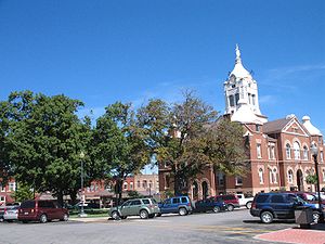
is Savannah
Savannah, Missouri
Savannah is a city in Andrew County, Missouri, United States. The population was 4,762 at the 2000 census. It is the county seat of Andrew County.Savannah is part of the St...
. The county was organized in 1841 and named for lawyer Andrew Jackson Davis. The county along with Buchanan
Buchanan County, Missouri
Buchanan County is a county located in the U.S. state of Missouri. As of 2010, the population was 89,201. Its county seat is Saint Joseph. When originally formed in 1838, the county was named Roberts County, after settler Hiram Roberts; it was renamed in 1839 for James Buchanan, then a U.S....
and DeKalb
DeKalb County, Missouri
DeKalb County is a county located in the U.S. state of Missouri. As of 2010, the population is 12,892. The county was organized in 1845 and is named after the American Revolutionary War general Johann de Kalb. The county along with Buchanan and Andrew counties in Missouri and Doniphan County,...
counties in Missouri and Doniphan County, Kansas
Doniphan County, Kansas
Doniphan County is a county located in Northeast Kansas, in the Central United States. As of the 2010 census, the county population was 7,945. Its county seat is Troy and its most populous city is Wathena. The county along with Buchanan, Andrew, and DeKalb counties in Missouri is included in...
, is included in the St. Joseph Metropolitan Statistical Area, which had an estimated population of 122,306 in 2006. It is currently part of the 12th district of the Missouri State Senate, currently represented by Brad Lager
Brad Lager
Brad Ronald Lager is a small business owner and a Republican politician from the state of Missouri. He is a current member of the Missouri State Senate from the 12th District as well as a former member of the Missouri House of Representatives...
, and the 28th district of the Missouri House of Representatives
Missouri House of Representatives
The Missouri House of Representatives is the lower chamber of the Missouri General Assembly. It has 163 members, representing districts with an average size of 31,000 residents. House members are elected for two-year terms during general elections held in even-numbered years.In 1992 Missouri...
, currently represented by Robert Schaaf.
History
(The following material is on a plaque erected by the State Historical Society of Missouri and State Highway Commission in 1960 and now located by the Andrew County Courthouse.)Andrew county, organized 1841, is one of 6 counties in the Indian Platte Purchase
Platte Purchase
The Platte Purchase was a land acquisition in 1836 by the United States government from Native American tribes all of which was east bank lands along the Missouri River that added to the northwest corner of the state of Missouri. The area acquired is almost as large as the states of Delaware and...
Territory annexed to Missouri, 1837. named for Andrew Jackson Davis, St. Louis editor, the county was first settled in the middle 1830's. Pioneers were from Ohio, Ind., Tenn., Ky., VA., and other parts of Missouri.
Savannah, the county seat, was laid out in 1841. First briefly called Union, it was renamed for Savannah, Ga. The Platte Co. R. R. (C. B. & Q.) reached there in 1860, and today's Chicago., Great Western in the late 1880s. In the post Civil War years, the town grew as shipping point and trading center.
A divided county during the Civil War, Andrew sent troops to both sides. In Aug., 1861 come 1500 from Andrew and other counties joined the pro-Southern Mo. State Guard at Camp Highly in eastern Andrew County while others joined a large Union cap in adjacent Gentry County. In 1861, Union troops seized "Northwest Democrat," a pro-Southern newspaper, in Savannah and troops from Camp Highly seized the "Plain Dealer," Union newspaper. Raiding Guerrilla bands overran the county through 1863.
Andrew County's glacial plains support fertile livestock, grain, and fruit farms. In the county are One Hundred and Two and Platte rivers and forming its west border are the Nodaway and Missouri. In 1804 the Lewis and Clark Expedition
Lewis and Clark Expedition
The Lewis and Clark Expedition, or ″Corps of Discovery Expedition" was the first transcontinental expedition to the Pacific Coast by the United States. Commissioned by President Thomas Jefferson and led by two Virginia-born veterans of Indian wars in the Ohio Valley, Meriwether Lewis and William...
camped on an island the mouth of Nodaway and members of fur trader Wilson P. Hunt's 1811 Astorian expedition wintered near the river’s mouth.
Among the county towns are Amazonia, once on the Missouri River, now inland, laid out in 1857 near the site of Nodaway City, early river port; Fillmore
Fillmore, Missouri
Fillmore is a city in Andrew County, Missouri, United States. The population was 211 at the 2000 census.-Geography:Fillmore is located at .According to the United States Census Bureau, the city has a total area of , all of it land....
1845; Whitesville, 1848; Rochester, 1848; Bolckow
Bolckow, Missouri
Bolckow is a city in Benton Township, Andrew County, Missouri, United States. The population was 234 at the 2000 census. It is part of the St. Joseph, MO–KS Metropolitan Statistical Area.-Geography:...
, 1868; Rosendale
Rosendale, Missouri
Rosendale is a city in Andrew County, Missouri, United States. The population was 180 at the 2000 census. Prior to 1881, Rosendale was known as Ogle Mills. It was later named after roses that grew in the area.Rosendale is part of the St...
, 1869; Rea
Rea, Missouri
Rea is a city in Andrew County, Missouri, United States. The population was 56 at the 2000 census. It is part of the St. Joseph, MO–KS Metropolitan Statistical Area.-Geography:Rea is located at ....
, 1877; Helena
Helena, Missouri
Helena is an unincorporated community in southeastern Andrew County, Missouri . It is located about twelve miles northeast of St. Joseph and is part of the St. Joseph, MO–KS Metropolitan Statistical Area....
, 1878; and Cosby
Cosby, Missouri
Cosby is a village in Andrew County, Missouri, United States. The population was 143 at the 2000 census. It is part of the St. Joseph, MO–KS Metropolitan Statistical Area.-Geography:Cosby is located at ....
, 1882.
Andrew County is the Birthplace of Nellie Tayloe Ross
Nellie Tayloe Ross
Nellie Tayloe Ross was an American politician, the 14th Governor of Wyoming from 1925 to 1927, and director of the United States Mint from 1933-1953. She was the first woman to serve as governor of a U.S. state. To date, she remains the only woman to have served as governor of Wyoming...
, the first woman Gov. of Wyo., 1925–27, first woman Dir. U.S. Mint; Joseph K. Toole (1851–1929) first Gov. of Mont., 1935; W. Elmer Holt, Gov. Mont., 1935 Edwin W. Toole (1839–1905) noted Mont. Lawyer; Eugene W. Caldwell (1870–1918) noted roentgenologist. In Savannah lived John P Altgeld, Gov. of Ill., 1893–97; Henry S, Kelley (1832–1911) legal textbook writer; James P. Somerville, one of founders of Sertoma Clubs International.
Notable natives
- Thomas Creekmore McCurry (1850–1939), Barack Obama's great-great grandfather (grandfather of his grandmother Madelyn Lee Payne).
- Nellie Tayloe RossNellie Tayloe RossNellie Tayloe Ross was an American politician, the 14th Governor of Wyoming from 1925 to 1927, and director of the United States Mint from 1933-1953. She was the first woman to serve as governor of a U.S. state. To date, she remains the only woman to have served as governor of Wyoming...
, the first woman governor (of Wyoming)
Museum and Historical Society
The Andrew County Museum and Historical Society celebrate the history of Andrew County through exhibits, programs, publications, and special events. The Museum and Society collect, preserve, research, and interpret documents and artifacts to promote the appreciation and preservation of the county's history and bring history to life in Andrew County.http://www.andrewcountymuseum.orgGeography
According to the 2000 census, the county has a total area of 436.5 square miles (1,130.5 km²), of which 435.18 square miles (1,127.1 km²) (or 99.70%) is land and 1.32 square miles (3.4 km²) (or 0.30%) is water.Adjacent counties
- Nodaway CountyNodaway County, MissouriNodaway County is a county located in the U.S. state of Missouri. The county was organized in 1845 and named for the Nodaway River.As of 2010, the population was 23,370...
(north) - Gentry CountyGentry County, MissouriAs of the census of 2000, there were 6,861 people, 2,747 households, and 1,884 families residing in the county. The population density was 14 people per square mile . There were 3,214 housing units at an average density of 6 per square mile...
(northeast) - DeKalb CountyDeKalb County, MissouriDeKalb County is a county located in the U.S. state of Missouri. As of 2010, the population is 12,892. The county was organized in 1845 and is named after the American Revolutionary War general Johann de Kalb. The county along with Buchanan and Andrew counties in Missouri and Doniphan County,...
(east) - Buchanan CountyBuchanan County, MissouriBuchanan County is a county located in the U.S. state of Missouri. As of 2010, the population was 89,201. Its county seat is Saint Joseph. When originally formed in 1838, the county was named Roberts County, after settler Hiram Roberts; it was renamed in 1839 for James Buchanan, then a U.S....
(south) - Doniphan County, KansasDoniphan County, KansasDoniphan County is a county located in Northeast Kansas, in the Central United States. As of the 2010 census, the county population was 7,945. Its county seat is Troy and its most populous city is Wathena. The county along with Buchanan, Andrew, and DeKalb counties in Missouri is included in...
(southwest) - Holt CountyHolt County, MissouriHolt County is a county located in the U.S. state of Missouri. The county is in the northwest part of the state. As of 2010, the population was 4,912. Its county seat is Oregon. The county was organized in 1841 and is named after the Missouri state legislator Dr...
(west)
Major highways
 Interstate 29
 Interstate 229Interstate 229 (Missouri)Interstate 229 in the state of Missouri, USA, is an approximately 14 mile Interstate Highway spur designed to speed traffic from Interstate 29 to downtown Saint Joseph....
 U.S. Route 59
 U.S. Route 71
 U.S. Route 169
 Route 48
Demographics
As of the censusCensus
A census is the procedure of systematically acquiring and recording information about the members of a given population. It is a regularly occurring and official count of a particular population. The term is used mostly in connection with national population and housing censuses; other common...
of 2000, there were 16,492 people, 6,273 households, and 4,635 families residing in the county. The population density
Population density
Population density is a measurement of population per unit area or unit volume. It is frequently applied to living organisms, and particularly to humans...
was 38 people per square mile (15/km²). There were 6,662 housing units at an average density of 15 per square mile (6/km²). The racial makeup of the county was 98.38% White
Race (United States Census)
Race and ethnicity in the United States Census, as defined by the Federal Office of Management and Budget and the United States Census Bureau, are self-identification data items in which residents choose the race or races with which they most closely identify, and indicate whether or not they are...
, 0.42% Black
Race (United States Census)
Race and ethnicity in the United States Census, as defined by the Federal Office of Management and Budget and the United States Census Bureau, are self-identification data items in which residents choose the race or races with which they most closely identify, and indicate whether or not they are...
or African American
Race (United States Census)
Race and ethnicity in the United States Census, as defined by the Federal Office of Management and Budget and the United States Census Bureau, are self-identification data items in which residents choose the race or races with which they most closely identify, and indicate whether or not they are...
, 0.34% Native American
Race (United States Census)
Race and ethnicity in the United States Census, as defined by the Federal Office of Management and Budget and the United States Census Bureau, are self-identification data items in which residents choose the race or races with which they most closely identify, and indicate whether or not they are...
, 0.22% Asian
Race (United States Census)
Race and ethnicity in the United States Census, as defined by the Federal Office of Management and Budget and the United States Census Bureau, are self-identification data items in which residents choose the race or races with which they most closely identify, and indicate whether or not they are...
, 0.01% Pacific Islander
Race (United States Census)
Race and ethnicity in the United States Census, as defined by the Federal Office of Management and Budget and the United States Census Bureau, are self-identification data items in which residents choose the race or races with which they most closely identify, and indicate whether or not they are...
, 0.18% from other races
Race (United States Census)
Race and ethnicity in the United States Census, as defined by the Federal Office of Management and Budget and the United States Census Bureau, are self-identification data items in which residents choose the race or races with which they most closely identify, and indicate whether or not they are...
, and 0.45% from two or more races. 0.84% of the population were Hispanic
Race (United States Census)
Race and ethnicity in the United States Census, as defined by the Federal Office of Management and Budget and the United States Census Bureau, are self-identification data items in which residents choose the race or races with which they most closely identify, and indicate whether or not they are...
or Latino
Race (United States Census)
Race and ethnicity in the United States Census, as defined by the Federal Office of Management and Budget and the United States Census Bureau, are self-identification data items in which residents choose the race or races with which they most closely identify, and indicate whether or not they are...
of any race.
There were 6,273 households out of which 34.50% had children under the age of 18 living with them, 62.70% were married couples
Marriage
Marriage is a social union or legal contract between people that creates kinship. It is an institution in which interpersonal relationships, usually intimate and sexual, are acknowledged in a variety of ways, depending on the culture or subculture in which it is found...
living together, 7.40% had a female householder with no husband present, and 26.10% were non-families. 22.30% of all households were made up of individuals and 10.50% had someone living alone who was 65 years of age or older. The average household size was 2.59 and the average family size was 3.03.
In the county the population was spread out with 26.40% under the age of 18, 7.90% from 18 to 24, 27.60% from 25 to 44, 23.70% from 45 to 64, and 14.40% who were 65 years of age or older. The median age was 38 years. For every 100 females there were 95.00 males. For every 100 females age 18 and over, there were 93.00 males.
The median income for a household in the county was $40,688, and the median income for a family was $46,067. Males had a median income of $32,955 versus $22,586 for females. The per capita income
Per capita income
Per capita income or income per person is a measure of mean income within an economic aggregate, such as a country or city. It is calculated by taking a measure of all sources of income in the aggregate and dividing it by the total population...
for the county was $19,375. About 6.40% of families and 8.20% of the population were below the poverty line, including 10.50% of those under age 18 and 8.00% of those age 65 or over.
Cities
- BolckowBolckow, MissouriBolckow is a city in Benton Township, Andrew County, Missouri, United States. The population was 234 at the 2000 census. It is part of the St. Joseph, MO–KS Metropolitan Statistical Area.-Geography:...
- FillmoreFillmore, MissouriFillmore is a city in Andrew County, Missouri, United States. The population was 211 at the 2000 census.-Geography:Fillmore is located at .According to the United States Census Bureau, the city has a total area of , all of it land....
- ReaRea, MissouriRea is a city in Andrew County, Missouri, United States. The population was 56 at the 2000 census. It is part of the St. Joseph, MO–KS Metropolitan Statistical Area.-Geography:Rea is located at ....
- RosendaleRosendale, MissouriRosendale is a city in Andrew County, Missouri, United States. The population was 180 at the 2000 census. Prior to 1881, Rosendale was known as Ogle Mills. It was later named after roses that grew in the area.Rosendale is part of the St...
- SavannahSavannah, MissouriSavannah is a city in Andrew County, Missouri, United States. The population was 4,762 at the 2000 census. It is the county seat of Andrew County.Savannah is part of the St...
Villages
- AmazoniaAmazonia, MissouriAmazonia is a village in Lincoln Township, Andrew County, Missouri, United States. The population was 277 at the 2000 census. It is part of the St. Joseph, MO–KS Metropolitan Statistical Area.-Geography:Amazonia is located at...
- CosbyCosby, MissouriCosby is a village in Andrew County, Missouri, United States. The population was 143 at the 2000 census. It is part of the St. Joseph, MO–KS Metropolitan Statistical Area.-Geography:Cosby is located at ....
- Country ClubCountry Club, MissouriCountry Club is a village in Andrew County, Missouri, United States. The population was 1,846 at the 2000 census. It is part of the St. Joseph, MO–KS Metropolitan Statistical Area.-Geography:Country Club is located at ....
Townships
Andrew County is divided into ten townshipsTownship (United States)
A township in the United States is a small geographic area. Townships range in size from 6 to 54 square miles , with being the norm.The term is used in three ways....
:
|
Lincoln Township, Andrew County, Missouri Lincoln Township is one of ten townships in Andrew County, Missouri, USA. As of the 2000 census, its population was 1,113.-Geography:Lincoln Township covers an area of and contains one incorporated settlement, Amazonia... Monroe Township, Andrew County, Missouri Monroe Township is one of ten townships in Andrew County, Missouri, USA. As of the 2000 census, its population was 777.-Geography:Monroe Township covers an area of and contains one incorporated settlement, Cosby... Nodaway Township, Andrew County, Missouri Nodaway Township is one of ten townships in Andrew County, Missouri, USA. As of the 2000 census, its population was 6,048.-Geography:Nodaway Township covers an area of and contains one incorporated settlement, Savannah... Platte Township, Andrew County, Missouri Platte Township is one of ten townships in Andrew County, Missouri, USA. As of the 2000 census, its population was 484.-Geography:Platte Township covers an area of and contains one incorporated settlement, Rea.... Rochester Township, Andrew County, Missouri Rochester Township is one of ten townships in Andrew County, Missouri, USA. As of the 2000 census, its population was 1,234.-Geography:Rochester Township covers an area of and contains no incorporated settlements.... |
See also
- National Register of Historic Places listings in Andrew County, Missouri
External links
- Digitized 1930 Plat Book of Andrew County from University of MissouriUniversity of MissouriThe University of Missouri System is a state university system providing centralized administration for four universities, a health care system, an extension program, five research and technology parks, and a publishing press. More than 64,000 students are currently enrolled at its four campuses...
Division of Special Collections, Archives, and Rare Books