
Phunphin
Encyclopedia
Phunphin is a district (Amphoe
) in the province Surat Thani
in the south of Thailand
. The town Tha Kham as the central town of the district has 22,478 citizens in an area of 14.2 square kilometer.
, Mueang Surat Thani
, Ban Na Doem
, Khian Sa
, Khiri Rat Nikhom
and Vibhavadi
. It also has a short coast to the Bandon Bay
to the northeast.
The main rivers of the district are the Tapi
and its tributary Phum Duang
, which flows into the Tapi at the town of Tha Kham.
in this district is the main passenger railway station of Surat Thani Province. At the Ban Thung Pho junction (kilometer 631) the southern railway branches to what was originally intended to connect the railway to Takua Thung district
, Phang Nga
, directly opposite of Phuket
. After the completion of 31 km of the railroad till Khiri Ratthanikhom in 1956 construction was stopped due to budget problems.
Also located in Phunphin are the Airport of Surat Thani
, the Inland Container Depot (ICD), and the Asian highway AH2
(Thai highway 41
) as the main road to connect to the other provinces
. Thai highway 401
connects Phunphin with the town Surat Thani.
), which are further subdivided into 98 villages (muban
). Tha Kham
is a town (thesaban mueang) and covers parts of tambon Tha Kham. There are further 16 Tambon administrative organizations (TAO).
Amphoe
An amphoe is the second level administrative subdivision of Thailand. Usually translated as district, amphoe make up the provinces, and are analogous to a county seat...
) in the province Surat Thani
Surat Thani Province
Surat Thani is the largest of the southern provinces of Thailand, on the eastern shore of the Gulf of Thailand. Surat Thani means City of Good People, the title given to the city by King Vajiravudh ....
in the south of Thailand
Thailand
Thailand , officially the Kingdom of Thailand , formerly known as Siam , is a country located at the centre of the Indochina peninsula and Southeast Asia. It is bordered to the north by Burma and Laos, to the east by Laos and Cambodia, to the south by the Gulf of Thailand and Malaysia, and to the...
. The town Tha Kham as the central town of the district has 22,478 citizens in an area of 14.2 square kilometer.
Geography
Neighboring districts are (from north clockwise) Tha ChangAmphoe Tha Chang, Surat Thani Province
Tha Chang is a district in the west of Surat Thani Province of southern Thailand.Neighboring districts are Chaiya to the north, the Bandon Bay to the east, Phunphin, Vibhavadi and Ban Ta Khun to the south, and to the west the district Kapoe of Ranong Province.-History:The minor district was...
, Mueang Surat Thani
Amphoe Mueang Surat Thani
Mueang Surat Thani is the capital district of Surat Thani Province in southern Thailand.-Geography:The district is located at the mouth of the Tapi River into the Bandon Bay of the Gulf of Thailand...
, Ban Na Doem
Amphoe Ban Na Doem
-Geography:Ban Na Doem is located in the center of Surat Thani province. Neighboring district are Mueang Surat Thani, Ban Na San, Khian Sa and Phunphin.The Tapi River forms part of the western boundary of the district...
, Khian Sa
Amphoe Khian Sa
Khian Sa is a district in Surat Thani Province, Thailand.Neighboring districts are Khiri Rat Nikhom, Phunphin, Ban Na Doem, Ban Na San, Wiang Sa, Phrasaeng and Phanom...
, Khiri Rat Nikhom
Amphoe Khiri Rat Nikhom
Khiri Rat Nikhom is a district in the west of Surat Thani Province of southern Thailand.- Geography :The western part of the district is located within the hills of the Phuket mountain range, while to the east the terrain is mostly flat...
and Vibhavadi
King Amphoe Vibhavadi
Vibhavadi is a district in the west of Surat Thani Province, southern Thailand.-Geography:Neighboring districts are Tha Chang, Phunphin, Khiri Rat Nikhom and Ban Ta Khun....
. It also has a short coast to the Bandon Bay
Bandon Bay
Bandon Bay is a bay in the Gulf of Thailand in the Surat Thani Province, extending from the Sui cape in Chaiya district in the northwest to the Kanchanadit district to the east. The total coastline is about 100 km. The bay is dominated by the estuary of the rivers Tapi and Phum Duang...
to the northeast.
The main rivers of the district are the Tapi
Tapi River, Thailand
The Tapi river is the longest river in southern Thailand. The river originates at the Khao Luang, and has a wide estuary into the Gulf of Thailand at Bandon Bay near the town of Surat Thani. It has a length of 230 km....
and its tributary Phum Duang
Phum Duang River
The Phum Duang River is a river in Surat Thani Province, Southern Thailand, the main tributary of the Tapi River....
, which flows into the Tapi at the town of Tha Kham.
Transportation
Phunphin is the transportation hub of the Surat Thani province. It has one railway intersection, 3 railway stations and 4 railstops. Surat Thani Railway StationSurat Thani Railway Station
Surat Thani Railway Station is the main railway station in Surat Thani Province. It is located on S.R.T. Southern Railway line km. 635+106, on the east bank of Tapi River in Tha Kham town, Phun Phin district. Surat Thani Station first opened in 1915, and was originally named Phun Phin Station...
in this district is the main passenger railway station of Surat Thani Province. At the Ban Thung Pho junction (kilometer 631) the southern railway branches to what was originally intended to connect the railway to Takua Thung district
Amphoe Takua Thung
Takua Thung is a district in the province Phang Nga in the south of Thailand.-History:Mueang Takua Thung is an ancient city same as Phang Nga and Takua Pa. The old city hall was located in Ban Khai, Tambon Bang Thong, Amphoe Thai Mueang. In 1894 Burmese troops attacked Mueang Takua Pa. Thalang...
, Phang Nga
Phang Nga Province
Phang Nga is one of the southern provinces of Thailand, on the shore to the Andaman Sea. Neighboring provinces are Ranong, Surat Thani and Krabi. To the south is the Phuket province, but without land boundary to Phang Nga....
, directly opposite of Phuket
Phuket Province
Phuket , formerly known as Thalang and, in Western sources, Junk Ceylon , is one of the southern provinces of Thailand...
. After the completion of 31 km of the railroad till Khiri Ratthanikhom in 1956 construction was stopped due to budget problems.
Also located in Phunphin are the Airport of Surat Thani
Surat Thani Airport
Surat Thani Airport is situated in the Phunphin district, Surat Thani province, Thailand. The airport, which is located 21 km west of Surat Thani, is also the Wing 7 Airforce base...
, the Inland Container Depot (ICD), and the Asian highway AH2
AH2
The AH2 is a road in the Asian Highway Network running 8230 miles from Denpasar, Indonesia to Khosravi, Iran. The route is as follows:-Indonesia:Denpasar — Surabaya — Surakarta — Semarang — Cikampek — Jakarta...
(Thai highway 41
Thailand Route 41
Route 41 starts at intersection with Route 4 in Chumphon Province. It goes southward passing through Surat Thani Province and Nakhon Si Thammarat Province. It ends at Phatthalung Province joining Route 4 again.-Route Details:...
) as the main road to connect to the other provinces
Provinces of Thailand
Thailand is divided into 76 provinces , which are geographically grouped into 6 regions. The capital Bangkok is not a province but a special administrative area and is included as the 77th province since it is administered at the same level as the other 76 provinces. The name of the provinces are...
. Thai highway 401
Thailand Route 401
Thailand Route 401 is a highway in southern Thailand. It starts from the west coast of the Thai-Malay Peninsula at an intersection with Route 4 near Amphoe Takua Pa, Phang Nga Province....
connects Phunphin with the town Surat Thani.
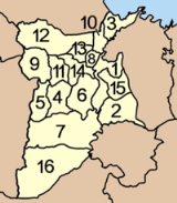
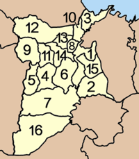
Administration
The district Phunphin is subdivided into 16 subdistricts (tambonTambon
Tambon is a local government unit in Thailand. Below district and province , they form the third administrative subdivision level. As of the 2009 there are 7255 tambon, not including the 169 khwaeng of Bangkok, which are set at the same administrative level, thus every district contains 8-10 tambon...
), which are further subdivided into 98 villages (muban
Muban
Muban is the lowest administrative subdivision of Thailand. Usually translated as village, they are the subdivision of tambon. As of 2008, there are 74944 administrative villages in Thailand. As of the 1990 census, the average village consisted of 144 households or 746 persons.A muban does not...
). Tha Kham
Tha Kham
Tha Kham is a town in southern Thailand. As of 2006 it covers an area of 14.10 km² and has a population of 20,349. It covers parts of the subdistrict Tha Kham of Phunphin district, Surat Thani Province.It is located at the shore of the Tapi River...
is a town (thesaban mueang) and covers parts of tambon Tha Kham. There are further 16 Tambon administrative organizations (TAO).
|
 |
External links
- amphoe.com (Thai)