

Amphoe Takua Thung
Encyclopedia
Takua Thung is a district (amphoe
) in the province Phang Nga
in the south of Thailand
.
Takua Thung is an ancient city same as Phang Nga and Takua Pa. The old city hall was located in Ban Khai, Tambon Bang Thong, Amphoe Thai Mueang
. In 1894 Burmese troops attacked Mueang Takua Pa. Thalang and Takua Thung were the next targets. Then people of Takua Thung moved the city center to Tambon Kra Som, where it is still located today.
Takua Thung was downgraded to be a district of Phang Nga in 1899.
and Mueang Phangnga. To the southwest is the Phang Nga Bay
, to the south is the district Thalang
of Phuket Province
, separated by the Pak Phra strait. To the west is the Andaman Sea
.
Namtok Raman Forest Park protects 0.2 km² around a scenic waterfall
. The park was established on October 26, 1983. Most of the coast to the Phang Nga bay is part of the Ao Phang Nga National Park
.
The most important temple within the district is Wat
Suwannakhuha, also commonly known as Wat Tham (lit. cave temple) due to several caves within a hill inside the temple area. Especially the largest of these caves is decorated with many Buddha
images as well as stalactite
s and stalagmite
s.
), which are further subdivided into 68 villages (muban
). There are two townships
(thesaban tambon) within the district - Krasom and Khok Kloi - each covering parts of the same-named tambon. Each of the tambon is administrated by a Tambon administrative organization (TAO).
Amphoe
An amphoe is the second level administrative subdivision of Thailand. Usually translated as district, amphoe make up the provinces, and are analogous to a county seat...
) in the province Phang Nga
Phang Nga Province
Phang Nga is one of the southern provinces of Thailand, on the shore to the Andaman Sea. Neighboring provinces are Ranong, Surat Thani and Krabi. To the south is the Phuket province, but without land boundary to Phang Nga....
in the south of Thailand
Thailand
Thailand , officially the Kingdom of Thailand , formerly known as Siam , is a country located at the centre of the Indochina peninsula and Southeast Asia. It is bordered to the north by Burma and Laos, to the east by Laos and Cambodia, to the south by the Gulf of Thailand and Malaysia, and to the...
.
History
MueangMueang
Mueang were historical semi-independent city-states or principalities in present-day Thailand, Laos, parts of northern Vietnam and the Shan State of Myanmar. Smaller Mueang were subordinate to more powerful neighboring Mueang, which in turn were subordinate to the central king, as described in...
Takua Thung is an ancient city same as Phang Nga and Takua Pa. The old city hall was located in Ban Khai, Tambon Bang Thong, Amphoe Thai Mueang
Amphoe Thai Mueang
Thai Mueang is a district in the province Phang Nga in the south of Thailand.-Geography:Neighboring districts are Takua Pa, Kapong, Mueang Phang Nga and Takua Thung. To the west is the Andaman Sea....
. In 1894 Burmese troops attacked Mueang Takua Pa. Thalang and Takua Thung were the next targets. Then people of Takua Thung moved the city center to Tambon Kra Som, where it is still located today.
Takua Thung was downgraded to be a district of Phang Nga in 1899.
Geography
Neighboring districts are (from the north clockwise) Thai MueangAmphoe Thai Mueang
Thai Mueang is a district in the province Phang Nga in the south of Thailand.-Geography:Neighboring districts are Takua Pa, Kapong, Mueang Phang Nga and Takua Thung. To the west is the Andaman Sea....
and Mueang Phangnga. To the southwest is the Phang Nga Bay
Phang Nga Bay
Phang Nga Bay is a 400 km² bay in the Andaman Sea between the island of Phuket and the mainland of the Malay peninsula of southern Thailand. Since 1981, an extensive section of the bay has been protected as the Ao Phang Nga National Park...
, to the south is the district Thalang
Amphoe Thalang
-History:Thalang was the original center of Phuket province, then named Mueang Thalang. The governor then had the title Phraya Thalang...
of Phuket Province
Phuket Province
Phuket , formerly known as Thalang and, in Western sources, Junk Ceylon , is one of the southern provinces of Thailand...
, separated by the Pak Phra strait. To the west is the Andaman Sea
Andaman Sea
The Andaman Sea or Burma Sea is a body of water to the southeast of the Bay of Bengal, south of Burma, west of Thailand and east of the Andaman Islands, India; it is part of the Indian Ocean....
.
Namtok Raman Forest Park protects 0.2 km² around a scenic waterfall
Waterfall
A waterfall is a place where flowing water rapidly drops in elevation as it flows over a steep region or a cliff.-Formation:Waterfalls are commonly formed when a river is young. At these times the channel is often narrow and deep. When the river courses over resistant bedrock, erosion happens...
. The park was established on October 26, 1983. Most of the coast to the Phang Nga bay is part of the Ao Phang Nga National Park
Ao Phang Nga National Park
Ao Phang Nga national park is located in Phang Nga Province in southern Thailand.Ao Phang Nga park was created by Royal decree and announced in the Royal Gazette under proclamation number 98 section 64 of April 29, 1981,- References :* *...
.
The most important temple within the district is Wat
Wat
A wat is a monastery temple in Cambodia, Thailand, or Laos. The word "wat" means "school".- Introduction :...
Suwannakhuha, also commonly known as Wat Tham (lit. cave temple) due to several caves within a hill inside the temple area. Especially the largest of these caves is decorated with many Buddha
Buddha
In Buddhism, buddhahood is the state of perfect enlightenment attained by a buddha .In Buddhism, the term buddha usually refers to one who has become enlightened...
images as well as stalactite
Stalactite
A stalactite , "to drip", and meaning "that which drips") is a type of speleothem that hangs from the ceiling of limestone caves. It is a type of dripstone...
s and stalagmite
Stalagmite
A stalagmite is a type of speleothem that rises from the floor of a limestone cave due to the dripping of mineralized solutions and the deposition of calcium carbonate. This stalagmite formation occurs only under certain pH conditions within the underground cavern. The corresponding formation on...
s.
Administration
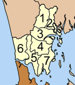
The district is subdivided into 7 subdistricts (tambonTambon
Tambon is a local government unit in Thailand. Below district and province , they form the third administrative subdivision level. As of the 2009 there are 7255 tambon, not including the 169 khwaeng of Bangkok, which are set at the same administrative level, thus every district contains 8-10 tambon...
), which are further subdivided into 68 villages (muban
Muban
Muban is the lowest administrative subdivision of Thailand. Usually translated as village, they are the subdivision of tambon. As of 2008, there are 74944 administrative villages in Thailand. As of the 1990 census, the average village consisted of 144 households or 746 persons.A muban does not...
). There are two townships
(thesaban tambon) within the district - Krasom and Khok Kloi - each covering parts of the same-named tambon. Each of the tambon is administrated by a Tambon administrative organization (TAO).
|
 |