
Amphoe Khiri Rat Nikhom
Encyclopedia
Khiri Rat Nikhom is a district (Amphoe
) in the west of Surat Thani Province
of southern Thailand
.
, while to the east the terrain is mostly flat. The main rivers are the Phum Duang
and Yan river.
Neighboring districts are (from north clockwise) Vibhavadi
, Phunphin
, Khian Sa
, Phanom
and Ban Ta Khun
.
(Rama IV), when it was a minor mueang
under Takua Pa and part of the Nakhon Si Thammarat kingdom
. During the thesaphiban administrative reforms in the 1890s it became a district within the province Chaiya, the present day Surat Thani.
In 1917 the district was renamed to Tha Khanon (ท่าขนอน), as the district office was located within that area. On April 12 1961 the name was changed back to the historical name.
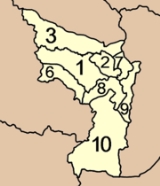
), which are further subdivided into 84 villages (muban
). Tha Khanon has subdistrict municipality (thesaban tambon) status and covers parts of tambon Tha Khanon. Each of the 8 tambon is administrated by a Tambon administrative organization (TAO).
The missing numbers 4 and 5 belong to the tambon which were split off to form King Amphoe Vibhavadi.
Amphoe
An amphoe is the second level administrative subdivision of Thailand. Usually translated as district, amphoe make up the provinces, and are analogous to a county seat...
) in the west of Surat Thani Province
Surat Thani Province
Surat Thani is the largest of the southern provinces of Thailand, on the eastern shore of the Gulf of Thailand. Surat Thani means City of Good People, the title given to the city by King Vajiravudh ....
of southern Thailand
Thailand
Thailand , officially the Kingdom of Thailand , formerly known as Siam , is a country located at the centre of the Indochina peninsula and Southeast Asia. It is bordered to the north by Burma and Laos, to the east by Laos and Cambodia, to the south by the Gulf of Thailand and Malaysia, and to the...
.
Geography
The western part of the district is located within the hills of the Phuket mountain rangePhuket mountain range
The Phuket mountain range is a mountain range in the Kra Isthmus, Thailand.-Geography:This chain of hills is one of the southern sections of the central cordillera, the mountain chain which runs from Tibet through all of the Malay peninsula....
, while to the east the terrain is mostly flat. The main rivers are the Phum Duang
Phum Duang River
The Phum Duang River is a river in Surat Thani Province, Southern Thailand, the main tributary of the Tapi River....
and Yan river.
Neighboring districts are (from north clockwise) Vibhavadi
King Amphoe Vibhavadi
Vibhavadi is a district in the west of Surat Thani Province, southern Thailand.-Geography:Neighboring districts are Tha Chang, Phunphin, Khiri Rat Nikhom and Ban Ta Khun....
, Phunphin
Phunphin
Phunphin is a district in the province Surat Thani in the south of Thailand. The town Tha Kham as the central town of the district has 22,478 citizens in an area of 14.2 square kilometer.-Geography:...
, Khian Sa
Amphoe Khian Sa
Khian Sa is a district in Surat Thani Province, Thailand.Neighboring districts are Khiri Rat Nikhom, Phunphin, Ban Na Doem, Ban Na San, Wiang Sa, Phrasaeng and Phanom...
, Phanom
Amphoe Phanom
Phanom is a district in the southwest of Surat Thani Province of southern Thailand.-Geography:The district is located within the hills of the Phuket mountain range, with around 60% of the area consisting of mountains and forests. The northwestern part of the district is protected in the Khao Sok...
and Ban Ta Khun
Amphoe Ban Ta Khun
Ban Ta Khun is a district in the west of Surat Thani Province of southern Thailand. It is both the largest district of the province areawise as well as the one with the lowest population density.-Geography:...
.
History
The town was first mentioned during the reign of King MongkutMongkut
Phra Bat Somdet Phra Poramenthramaha Mongkut Phra Chom Klao Chao Yu Hua , or Rama IV, known in foreign countries as King Mongkut , was the fourth monarch of Siam under the House of Chakri, ruling from 1851-1868...
(Rama IV), when it was a minor mueang
Mueang
Mueang were historical semi-independent city-states or principalities in present-day Thailand, Laos, parts of northern Vietnam and the Shan State of Myanmar. Smaller Mueang were subordinate to more powerful neighboring Mueang, which in turn were subordinate to the central king, as described in...
under Takua Pa and part of the Nakhon Si Thammarat kingdom
Nakhon Si Thammarat kingdom
Nakhon Si Thammarat Kingdom was one of the major constituent city states of the Siamese kingdoms of Sukhothai and later Ayutthaya and controlled a big part of the Malay peninsula...
. During the thesaphiban administrative reforms in the 1890s it became a district within the province Chaiya, the present day Surat Thani.
In 1917 the district was renamed to Tha Khanon (ท่าขนอน), as the district office was located within that area. On April 12 1961 the name was changed back to the historical name.
Traffic
Khiri Rat Nikhom is the endpoint of a branch of the southern railway, originally scheduled to run till Phuket but construction was stopped in 1956.Administration
The district is subdivided into 8 subdistricts (tambonTambon
Tambon is a local government unit in Thailand. Below district and province , they form the third administrative subdivision level. As of the 2009 there are 7255 tambon, not including the 169 khwaeng of Bangkok, which are set at the same administrative level, thus every district contains 8-10 tambon...
), which are further subdivided into 84 villages (muban
Muban
Muban is the lowest administrative subdivision of Thailand. Usually translated as village, they are the subdivision of tambon. As of 2008, there are 74944 administrative villages in Thailand. As of the 1990 census, the average village consisted of 144 households or 746 persons.A muban does not...
). Tha Khanon has subdistrict municipality (thesaban tambon) status and covers parts of tambon Tha Khanon. Each of the 8 tambon is administrated by a Tambon administrative organization (TAO).
|
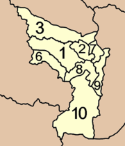 |
The missing numbers 4 and 5 belong to the tambon which were split off to form King Amphoe Vibhavadi.
External links
- amphoe.com
- http://cddweb.cdd.go.th/khirirat/index.htm