

Amphoe Khian Sa
Encyclopedia
Khian Sa is a district (Amphoe
) in Surat Thani Province
, Thailand
.
Neighboring districts are (from the north clockwise) Khiri Rat Nikhom
, Phunphin, Ban Na Doem
, Ban Na San
, Wiang Sa
, Phrasaeng
and Phanom
. It is about 60 kilometers away from the town Surat Thani.
, which also forms part of the eastern boundary of the district. The area of the district is mostly used for rice farming or rubber plantations, while along the river are swamps like the Nong Thung Thong
swamp.
The main road through the district is Thailand Route 44
, which connects Krabi
with Khanom
.
. On April 1, 1974 it was elevated to full district status.
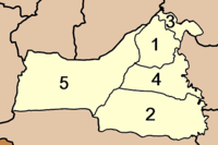
 The district is subdivided into 5 subdistricts (tambon
), which in turn are further subdivided into 52 villages (muban
). Khian Sa has township status (thesaban tambon), covering parts of the tambon Khian Sa. Each of the tambon is administrated by a Tambon administrative office (TAO).
Amphoe
An amphoe is the second level administrative subdivision of Thailand. Usually translated as district, amphoe make up the provinces, and are analogous to a county seat...
) in Surat Thani Province
Surat Thani Province
Surat Thani is the largest of the southern provinces of Thailand, on the eastern shore of the Gulf of Thailand. Surat Thani means City of Good People, the title given to the city by King Vajiravudh ....
, Thailand
Thailand
Thailand , officially the Kingdom of Thailand , formerly known as Siam , is a country located at the centre of the Indochina peninsula and Southeast Asia. It is bordered to the north by Burma and Laos, to the east by Laos and Cambodia, to the south by the Gulf of Thailand and Malaysia, and to the...
.
Neighboring districts are (from the north clockwise) Khiri Rat Nikhom
Amphoe Khiri Rat Nikhom
Khiri Rat Nikhom is a district in the west of Surat Thani Province of southern Thailand.- Geography :The western part of the district is located within the hills of the Phuket mountain range, while to the east the terrain is mostly flat...
, Phunphin, Ban Na Doem
Amphoe Ban Na Doem
-Geography:Ban Na Doem is located in the center of Surat Thani province. Neighboring district are Mueang Surat Thani, Ban Na San, Khian Sa and Phunphin.The Tapi River forms part of the western boundary of the district...
, Ban Na San
Amphoe Ban Na San
-Geography:Neighboring districts are Nopphitam and Phipun of Nakhon Si Thammarat Province, Wiang Sa, Khian Sa, Ban Na Doem, Mueang Surat Thani and Kanchanadit....
, Wiang Sa
Amphoe Wiang Sa, Surat Thani Province
-Geography:Wiang Sa is located in the southeast of Surat Thani province. Neighboring district are Phrasaeng, Khian Sa and Ban Na San of Surat Thani, and Phipun, Chawang and Tham Phannara of Nakhon Si Thammarat Province....
, Phrasaeng
Amphoe Phrasaeng
-Geography:The district is located in the south of the province. Neighboring districts are Phanom, Khian Sa, Wiang Sa of Surat Thani Province, Tham Phannara, Thung Yai of Nakhon Si Thammarat Province, Chai Buri of Surat Thani Province again, Khao Phanom and Plai Phraya of Krabi Province.At the...
and Phanom
Amphoe Phanom
Phanom is a district in the southwest of Surat Thani Province of southern Thailand.-Geography:The district is located within the hills of the Phuket mountain range, with around 60% of the area consisting of mountains and forests. The northwestern part of the district is protected in the Khao Sok...
. It is about 60 kilometers away from the town Surat Thani.
Geography
The district is located in the Khian Sa basin, which is crossed by the Tapi RiverTapi River, Thailand
The Tapi river is the longest river in southern Thailand. The river originates at the Khao Luang, and has a wide estuary into the Gulf of Thailand at Bandon Bay near the town of Surat Thani. It has a length of 230 km....
, which also forms part of the eastern boundary of the district. The area of the district is mostly used for rice farming or rubber plantations, while along the river are swamps like the Nong Thung Thong
Nong Thung Thong
Nong Thung Thong is a swamp on the east bank of the Tapi River in Khian Sa district, Surat Thani Province, southern Thailand.The area, together with the Nong Tung Ka on the west bank of the river, forms a complex of grassland and swamps along the river...
swamp.
The main road through the district is Thailand Route 44
Thailand Route 44
Route 44 is part of land bridge project. It starts at intersection with Route 4 in Krabi Province, running northeast, and ends at intersection with Route 401 in Surat Thani Province.-Route Details:...
, which connects Krabi
Krabi
Krabi is a town on the west coast of southern Thailand at the mouth of the Krabi River where it empties in Phangnga Bay. As of 2005 the town has a population of 24,986. The town is the capital of Krabi Province and Krabi district...
with Khanom
Amphoe Khanom
Khanom is the northernmost district of Nakhon Si Thammarat Province, southern Thailand.-Geography:The district is located in the north of the province. To the west is Surat Thani Province, while to the north and east is the Gulf of Thailand...
.
History
The district was formed as a minor district (king amphoe) on December 15, 1970, splitting the two tambon Khian Sa and Phuang Phromkhon from Ban Na San district. On April 1, 1974 it was elevated to full district status.
Administration
Tambon
Tambon is a local government unit in Thailand. Below district and province , they form the third administrative subdivision level. As of the 2009 there are 7255 tambon, not including the 169 khwaeng of Bangkok, which are set at the same administrative level, thus every district contains 8-10 tambon...
), which in turn are further subdivided into 52 villages (muban
Muban
Muban is the lowest administrative subdivision of Thailand. Usually translated as village, they are the subdivision of tambon. As of 2008, there are 74944 administrative villages in Thailand. As of the 1990 census, the average village consisted of 144 households or 746 persons.A muban does not...
). Khian Sa has township status (thesaban tambon), covering parts of the tambon Khian Sa. Each of the tambon is administrated by a Tambon administrative office (TAO).
|
 |
External links
- amphoe.com
- Khian Sa police station (Thai only)