
King Amphoe Vibhavadi
Encyclopedia
Vibhavadi is a district (Amphoe
) in the west of Surat Thani Province
, southern Thailand.
, Phunphin
, Khiri Rat Nikhom
and Ban Ta Khun
.
The district is located in the hills of the Phuket mountain range
, with part of the district being protected in the Khlong Yan Wildlife Sanctuary
and the Kaeng Krung National Park
.
. It is named after princess Vibhavadi Rangsit, who was killed in 1977 when rebels shot down her helicopter in the east of Surat Thani province.
Following a decision of the Thai government on May 15 2007, all of the 81 minor districts were to be upgraded to full districts. With the publishing in the Royal Gazette on August 24 the upgrade became official.
branch.
). These are further subdivided into 31 villages (muban
). There are no municipal (thesaban
) areas. The tambon are each administrated by a tambon administrative organization (TAO).
Amphoe
An amphoe is the second level administrative subdivision of Thailand. Usually translated as district, amphoe make up the provinces, and are analogous to a county seat...
) in the west of Surat Thani Province
Surat Thani Province
Surat Thani is the largest of the southern provinces of Thailand, on the eastern shore of the Gulf of Thailand. Surat Thani means City of Good People, the title given to the city by King Vajiravudh ....
, southern Thailand.
Geography
Neighboring districts are (from north clockwise) Tha ChangAmphoe Tha Chang, Surat Thani Province
Tha Chang is a district in the west of Surat Thani Province of southern Thailand.Neighboring districts are Chaiya to the north, the Bandon Bay to the east, Phunphin, Vibhavadi and Ban Ta Khun to the south, and to the west the district Kapoe of Ranong Province.-History:The minor district was...
, Phunphin
Phunphin
Phunphin is a district in the province Surat Thani in the south of Thailand. The town Tha Kham as the central town of the district has 22,478 citizens in an area of 14.2 square kilometer.-Geography:...
, Khiri Rat Nikhom
Amphoe Khiri Rat Nikhom
Khiri Rat Nikhom is a district in the west of Surat Thani Province of southern Thailand.- Geography :The western part of the district is located within the hills of the Phuket mountain range, while to the east the terrain is mostly flat...
and Ban Ta Khun
Amphoe Ban Ta Khun
Ban Ta Khun is a district in the west of Surat Thani Province of southern Thailand. It is both the largest district of the province areawise as well as the one with the lowest population density.-Geography:...
.
The district is located in the hills of the Phuket mountain range
Phuket mountain range
The Phuket mountain range is a mountain range in the Kra Isthmus, Thailand.-Geography:This chain of hills is one of the southern sections of the central cordillera, the mountain chain which runs from Tibet through all of the Malay peninsula....
, with part of the district being protected in the Khlong Yan Wildlife Sanctuary
Khlong Yan Wildlife Sanctuary
Khlong Yan is a wildlife sanctuary in southern Thailand, located in the west of Surat Thani Province. It is located between the Khao Sok and Kaeng Krung National Park within the hills of the Phuket mountain range....
and the Kaeng Krung National Park
Kaeng Krung National Park
Kaeng Krung is a national park in southern Thailand, protecting 541 km² of forests within the Phuket mountain range. It has been declared a national park on December 4, 1990....
.
History
The minor district (King Amphoe) was created on April 22, 1992 by splitting off two tambon from Khiri Rat Nikhom districtAmphoe Khiri Rat Nikhom
Khiri Rat Nikhom is a district in the west of Surat Thani Province of southern Thailand.- Geography :The western part of the district is located within the hills of the Phuket mountain range, while to the east the terrain is mostly flat...
. It is named after princess Vibhavadi Rangsit, who was killed in 1977 when rebels shot down her helicopter in the east of Surat Thani province.
Following a decision of the Thai government on May 15 2007, all of the 81 minor districts were to be upgraded to full districts. With the publishing in the Royal Gazette on August 24 the upgrade became official.
Temples
There are three buddhist temples in the district, all of the MahayanaMahayana
Mahāyāna is one of the two main existing branches of Buddhism and a term for classification of Buddhist philosophies and practice...
branch.
- Pho Noi (โพธิ์น้อย)
- Aran Ya Ram (อรัญญาราม)
- Vibhavadi Wana Ram (วิภาวดีวนาราม)
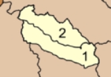
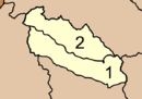
Administration
The district is subdivided into two subdistricts (tambonTambon
Tambon is a local government unit in Thailand. Below district and province , they form the third administrative subdivision level. As of the 2009 there are 7255 tambon, not including the 169 khwaeng of Bangkok, which are set at the same administrative level, thus every district contains 8-10 tambon...
). These are further subdivided into 31 villages (muban
Muban
Muban is the lowest administrative subdivision of Thailand. Usually translated as village, they are the subdivision of tambon. As of 2008, there are 74944 administrative villages in Thailand. As of the 1990 census, the average village consisted of 144 households or 746 persons.A muban does not...
). There are no municipal (thesaban
Thesaban
Thesaban are the municipalities in Thailand. There are three levels of municipalities - city, town and subdistrict municipality. Both Bangkok and Pattaya are special municipal entities outside the thesaban system....
) areas. The tambon are each administrated by a tambon administrative organization (TAO).
|
 |