

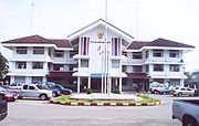
Amphoe Mueang Surat Thani
Encyclopedia
Mueang Surat Thani is the capital district (Amphoe Mueang) of Surat Thani Province
in southern Thailand.
into the Bandon Bay
of the Gulf of Thailand
. Neighboring districts are (from the east clockwise) Kanchanadit, Ban Na San
, Ban Na Doem
and Phunphin
.
To the east of the district the Thathong River marks the natural boundary to Kanchanadit, while the boundary to Phunphin is partially marked by the western arm of the Tapi river. The Khun Thale is a small lake located in the center of the district. The Khao Tha Phet
non-hunting area protects 4.65 km² of a hill south of the city Surat Thani.
The Khun Thale swamp to the south of the district is the source of two short minor rivers which meander
through the city, Khlong Makham Tia and Khlong Tha Kup.
Chaiya and Kanchanadit were merged into a single province named Chaiya, with its administrative center located at Ban Don, with the district named Ban Don (บ้านดอน) accordingly. In 1915 the province was renamed to Surat Thani. In 1938 the district was renamed to Mueang Surat Thani, when all capital districts were named according to the corresponding province name.
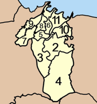
 The district is subdivided into 11 subdistricts (tambon
), which are further subdivided into 60 villages (muban
). Surat Thani
itself is a city (thesaban nakhon) and covers the tambon Talad and Bang Kung, and parts of the tambon Khlong Chanak, Bang Chana, Bang Bai Mai and Makham Tia. Wat Pradu has township (thesaban tambon) status. There are also 9 tambon administrative organizations (TAO), for each tambon except the two completely covered by the city.
Surat Thani Province
Surat Thani is the largest of the southern provinces of Thailand, on the eastern shore of the Gulf of Thailand. Surat Thani means City of Good People, the title given to the city by King Vajiravudh ....
in southern Thailand.
Geography
The district is located at the mouth of the Tapi RiverTapi River, Thailand
The Tapi river is the longest river in southern Thailand. The river originates at the Khao Luang, and has a wide estuary into the Gulf of Thailand at Bandon Bay near the town of Surat Thani. It has a length of 230 km....
into the Bandon Bay
Bandon Bay
Bandon Bay is a bay in the Gulf of Thailand in the Surat Thani Province, extending from the Sui cape in Chaiya district in the northwest to the Kanchanadit district to the east. The total coastline is about 100 km. The bay is dominated by the estuary of the rivers Tapi and Phum Duang...
of the Gulf of Thailand
Gulf of Thailand
The Gulf of Thailand , also known in to Malays as Teluk Siam literally meant Gulf of Siam, is a shallow arm of the South China Sea.-Geography:...
. Neighboring districts are (from the east clockwise) Kanchanadit, Ban Na San
Amphoe Ban Na San
-Geography:Neighboring districts are Nopphitam and Phipun of Nakhon Si Thammarat Province, Wiang Sa, Khian Sa, Ban Na Doem, Mueang Surat Thani and Kanchanadit....
, Ban Na Doem
Amphoe Ban Na Doem
-Geography:Ban Na Doem is located in the center of Surat Thani province. Neighboring district are Mueang Surat Thani, Ban Na San, Khian Sa and Phunphin.The Tapi River forms part of the western boundary of the district...
and Phunphin
Phunphin
Phunphin is a district in the province Surat Thani in the south of Thailand. The town Tha Kham as the central town of the district has 22,478 citizens in an area of 14.2 square kilometer.-Geography:...
.
To the east of the district the Thathong River marks the natural boundary to Kanchanadit, while the boundary to Phunphin is partially marked by the western arm of the Tapi river. The Khun Thale is a small lake located in the center of the district. The Khao Tha Phet
Khao Tha Phet
Khao Tha Phet is a hill near the town of Surat Thani, southern Thailand. It is located in Tambon Makham Tia, Amphoe Mueang Surat Thani. The hill has an altitude of about 210m above sea level and offers a good view over the town Surat Thani....
non-hunting area protects 4.65 km² of a hill south of the city Surat Thani.
The Khun Thale swamp to the south of the district is the source of two short minor rivers which meander
Meander
A meander in general is a bend in a sinuous watercourse. A meander is formed when the moving water in a stream erodes the outer banks and widens its valley. A stream of any volume may assume a meandering course, alternately eroding sediments from the outside of a bend and depositing them on the...
through the city, Khlong Makham Tia and Khlong Tha Kup.
History
The district was formed when in 1897 MueangMueang
Mueang were historical semi-independent city-states or principalities in present-day Thailand, Laos, parts of northern Vietnam and the Shan State of Myanmar. Smaller Mueang were subordinate to more powerful neighboring Mueang, which in turn were subordinate to the central king, as described in...
Chaiya and Kanchanadit were merged into a single province named Chaiya, with its administrative center located at Ban Don, with the district named Ban Don (บ้านดอน) accordingly. In 1915 the province was renamed to Surat Thani. In 1938 the district was renamed to Mueang Surat Thani, when all capital districts were named according to the corresponding province name.
Administration
Tambon
Tambon is a local government unit in Thailand. Below district and province , they form the third administrative subdivision level. As of the 2009 there are 7255 tambon, not including the 169 khwaeng of Bangkok, which are set at the same administrative level, thus every district contains 8-10 tambon...
), which are further subdivided into 60 villages (muban
Muban
Muban is the lowest administrative subdivision of Thailand. Usually translated as village, they are the subdivision of tambon. As of 2008, there are 74944 administrative villages in Thailand. As of the 1990 census, the average village consisted of 144 households or 746 persons.A muban does not...
). Surat Thani
Surat Thani
Surat Thani is a city in Amphoe Mueang Surat Thani, Surat Thani Province, southern Thailand. It is the capital of the province Surat Thani. The city has a population of 128,179 , and an area of 68.97 square kilometers. The city's population density is 1,858.47 inhabitants per km².Suran Thani is...
itself is a city (thesaban nakhon) and covers the tambon Talad and Bang Kung, and parts of the tambon Khlong Chanak, Bang Chana, Bang Bai Mai and Makham Tia. Wat Pradu has township (thesaban tambon) status. There are also 9 tambon administrative organizations (TAO), for each tambon except the two completely covered by the city.
|
 |