
Petersham, New South Wales
Encyclopedia
Suburb
The word suburb mostly refers to a residential area, either existing as part of a city or as a separate residential community within commuting distance of a city . Some suburbs have a degree of administrative autonomy, and most have lower population density than inner city neighborhoods...
in the Inner West
Inner West (Sydney)
The Inner West is a general term which is used to describe the metropolitan area directly to the west of the Sydney central business district, New South Wales, Australia...
of Sydney
Sydney
Sydney is the most populous city in Australia and the state capital of New South Wales. Sydney is located on Australia's south-east coast of the Tasman Sea. As of June 2010, the greater metropolitan area had an approximate population of 4.6 million people...
, in the state of New South Wales
New South Wales
New South Wales is a state of :Australia, located in the east of the country. It is bordered by Queensland, Victoria and South Australia to the north, south and west respectively. To the east, the state is bordered by the Tasman Sea, which forms part of the Pacific Ocean. New South Wales...
, Australia
Australia
Australia , officially the Commonwealth of Australia, is a country in the Southern Hemisphere comprising the mainland of the Australian continent, the island of Tasmania, and numerous smaller islands in the Indian and Pacific Oceans. It is the world's sixth-largest country by total area...
. Petersham is located 6 kilometres south-west of the Sydney central business district
Sydney central business district
The Sydney central business district is the main commercial centre of Sydney, New South Wales, Australia. It extends southwards for about 3 kilometres from Sydney Cove, the point of first European settlement. Its north–south axis runs from Circular Quay in the north to Central railway station in...
, in the local government area of Marrickville Council
Marrickville Council
Marrickville Council is a Local Government Area situated in the Inner West region of Sydney, Australia.The area is bounded by Leichhardt to the north, the City of Sydney to the east and north-east, the City of Botany Bay to the south-east, Rockdale to the south, Canterbury to the west, and...
. Petersham is known for its large Portuguese
Portugal
Portugal , officially the Portuguese Republic is a country situated in southwestern Europe on the Iberian Peninsula. Portugal is the westernmost country of Europe, and is bordered by the Atlantic Ocean to the West and South and by Spain to the North and East. The Atlantic archipelagos of the...
community which is reflected in the many Portuguese businesses and restaurants.
Petersham is bordered by the suburbs of Leichhardt
Leichhardt, New South Wales
Leichhardt is a suburb in the inner-west of Sydney in New South Wales, Australia. Leichhardt is located 5 kilometres west of the Sydney central business district and is the administrative centre for the local government area of the Municipality of Leichhardt...
to the north, Stanmore
Stanmore, New South Wales
Stanmore is a suburb in the inner-west of Sydney, in New South Wales, Australia. Stanmore is located 6 kilometres south-west of the Sydney central business district and is part of the local government area of Marrickville Council.-History:...
to the east, Marrickville
Marrickville, New South Wales
Marrickville, a suburb of Sydney's Inner West is located 7 kilometres south-west of the Sydney central business district in the state of New South Wales, Australia and is the largest suburb in the Marrickville Council local government area...
to the south and Lewisham
Lewisham, New South Wales
Lewisham is a suburb in the inner-west of Sydney, in the state of New South Wales, Australia. Lewisham is located 8 kilometres south-west of the Sydney central business district, in the local government area of Marrickville Council. The postcode is 2049...
to the west. Taverner's Hill named after Fred Taverner is a locality in the western part of the suburb.
European settlement
Major Francis Grose (Lieutenant-Governor)Francis Grose (Lieutenant-Governor)
Lieutenant-General Francis Grose was a soldier and Lieutenant Governor of New South Wales.-Early life:Grose was born in Greenland, Middlesex, England around 1758. He was the eldest son of Francis Grose the well-known English antiquary, and Catherine Jordan...
sent workmen to the area in 1793 to clear the bush and plant corn and wheat. He named the area Peters-Ham or Petersham
Petersham
Petersham is a place in the London Borough of Richmond upon Thames on the east of the bend in the River Thames south of Richmond, which it shares with neighbouring Ham. It provides the foreground of the scenic view from Richmond Hill across Petersham Meadows, with Ham House further along the River...
after his native village in Surrey
Surrey
Surrey is a county in the South East of England and is one of the Home Counties. The county borders Greater London, Kent, East Sussex, West Sussex, Hampshire and Berkshire. The historic county town is Guildford. Surrey County Council sits at Kingston upon Thames, although this has been part of...
, England
England
England is a country that is part of the United Kingdom. It shares land borders with Scotland to the north and Wales to the west; the Irish Sea is to the north west, the Celtic Sea to the south west, with the North Sea to the east and the English Channel to the south separating it from continental...
. Petersham remained an agricultural area, winning awards for some of the best crops and stock in the colony in 1803. Kangaroo hunting was also popular in the area. The name was also used for the surrounding parish
Petersham Parish, Cumberland
Petersham Parish is one of the 57 parishes of Cumberland County, New South Wales, a cadastral unit for use on land titles. It is located to the south of Iron Cove, Rozelle Bay and the Parramatta River, and to the north of Cooks River. It includes the suburbs of Balmain, Leichhardt, Petersham,...
.
Dr Robert Wardell (1793–1834) purchased land from many grantees in the district and in 1831 his estate eventually stretched 2000 acres (8.1 km²) from Petersham to the Cooks River
Cooks River
The Cooks River is a 23 kilometre long urban waterway of south-western Sydney, New South Wales, Australia emptying into Botany Bay. The course of the river has been altered to accommodate various developments along its shore...
. Following his murder by escaped convicts in 1834, the estate was subdivided. The train line from Sydney
Central railway station, Sydney
Central Railway Station, the largest railway station in Australia, is at the southern end of the Sydney CBD. It services almost all the lines on the CityRail network, and is the major terminus for interurban and interstate rail services...
to Parramatta opened in 1855 and trains stopped here from 1857. A platform was built in 1863. The original Petersham post office
Post office
A post office is a facility forming part of a postal system for the posting, receipt, sorting, handling, transmission or delivery of mail.Post offices offer mail-related services such as post office boxes, postage and packaging supplies...
became Annandale
Annandale, New South Wales
Annandale is a suburb of Inner West Sydney in the state of New South Wales, Australia. Annandale is located within 3-5 kilometres west of the Sydney central business district and is part of the local government area of the Municipality of Leichhardt. Annandale's northern end lies on Rozelle Bay,...
in 1855. Another post office opened as Norwood in May 1860 and was moved to Petersham station in 1870. The first public school opened in 1878.
Petersham municipality
Municipality of Petersham
The Municipality of Petersham was a former Local Government Area of Sydney, New South Wales, Australia. The small municipality was proclaimed as a borough in 1871 and was centred around the suburbs of Lewisham, Petersham and Stanmore...
was incorporated in 1872. The local council merged with Marrickville and St Peters
St Peters, New South Wales
St Peters is a suburb in the inner west of Sydney, in the state of New South Wales, Australia. St Peters is located 7 kilometres south of the Sydney central business district, in the local government area of Marrickville Council.-History:...
in 1948 to form the Municipality of Marrickville
Marrickville Council
Marrickville Council is a Local Government Area situated in the Inner West region of Sydney, Australia.The area is bounded by Leichhardt to the north, the City of Sydney to the east and north-east, the City of Botany Bay to the south-east, Rockdale to the south, Canterbury to the west, and...
. In 1916, the Boys' section of Fort Street High School
Fort Street High School
Fort Street High School is a co-educational, academically selective, public high school currently located at Petersham, an inner western suburb of Sydney, New South Wales, Australia....
moved to Petersham from Observatory Hill
Sydney Observatory
Sydney Observatory is located on a hill now known as 'Observatory Hill' in an area in the centre of Sydney. The site evolved from a fort built on 'Windmill Hill' in the early 19th century to an astronomical observatory during the nineteenth century...
, followed by the Girls' section in 1975.
Wartime plane crash
MosquitoDe Havilland Mosquito
The de Havilland DH.98 Mosquito was a British multi-role combat aircraft that served during the Second World War and the postwar era. It was known affectionately as the "Mossie" to its crews and was also nicknamed "The Wooden Wonder"...
HR576 RAF (UK)
Royal Air Force
The Royal Air Force is the aerial warfare service branch of the British Armed Forces. Formed on 1 April 1918, it is the oldest independent air force in the world...
disintegrated over the inner western Sydney suburbs of Leichhardt
Leichhardt, New South Wales
Leichhardt is a suburb in the inner-west of Sydney in New South Wales, Australia. Leichhardt is located 5 kilometres west of the Sydney central business district and is the administrative centre for the local government area of the Municipality of Leichhardt...
and Petersham on 2 May 1945 during an air test flight
Flight test
Flight test is a branch of aeronautical engineering that develops and gathers data during flight of an aircraft and then analyzes the data to evaluate the flight characteristics of the aircraft and validate its design, including safety aspects...
. The crew of two were killed but fortunately no one on the ground was seriously injured by the falling debris of the Mosquito. The Daily Telegraph of 3 May 1945 stated that two civilians were injured and a total of 18 properties were damaged. Five houses were set on fire by the falling debris.
It was suspected that a violent pull out from a power dive, with its associated high 'g' forces may have led to the structural failure
Structural failure
Structural failure refers to loss of the load-carrying capacity of a component or member within a structure or of the structure itself. Structural failure is initiated when the material is stressed to its strength limit, thus causing fracture or excessive deformations...
of the aircraft. The two crew members tried to eject from the aircraft but they were not high enough for their parachutes to open. Flight Lieutenant
Flight Lieutenant
Flight lieutenant is a junior commissioned rank in the Royal Air Force and the air forces of many Commonwealth countries. It ranks above flying officer and immediately below squadron leader. The name of the rank is the complete phrase; it is never shortened to "lieutenant"...
David Rochford of Oxford, England
Oxford
The city of Oxford is the county town of Oxfordshire, England. The city, made prominent by its medieval university, has a population of just under 165,000, with 153,900 living within the district boundary. It lies about 50 miles north-west of London. The rivers Cherwell and Thames run through...
and LAC Charles Boydell from Mosman
Mosman, New South Wales
Mosman is a suburb on the Lower North Shore of Sydney, in the state of New South Wales, Australia. Mosman is located 8 kilometres north-east of the Sydney central business district and is the administrative centre for the local government area of the Municipality of Mosman.-Localities:In February...
were both killed. F/Lt Rochford's body was found in the playground of Petersham Public School while LAC Boydell's body was found on the roof of a railway building about 100 metres away.
Commercial area
A small row of shops lines New Canterbury Road and extends down Audley Street towards the railway sation. There are some Portuguese businesses here including several PortuguesePortugal
Portugal , officially the Portuguese Republic is a country situated in southwestern Europe on the Iberian Peninsula. Portugal is the westernmost country of Europe, and is bordered by the Atlantic Ocean to the West and South and by Spain to the North and East. The Atlantic archipelagos of the...
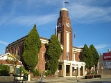
restaurants, some of which are renowned for selling traditional styled flame-grilled chicken and cod dishes. Local landmarks include the Petersham Town Hall, the water tower
Water tower
A water tower or elevated water tower is a large elevated drinking water storage container constructed to hold a water supply at a height sufficient to pressurize a water distribution system....
and Petersham Park.
The Great Western Avenue or Parramatta Road passes Petersham where shops are along the street. The car dealer Sydney City Subaru
Subaru
; is the automobile manufacturing division of Japanese transportation conglomerate Fuji Heavy Industries .Subaru is internationally known for their use of the boxer engine layout popularized in cars by the Volkswagen Beetle and Porsche 911, in most of their vehicles above 1500 cc as well as...
is located in this area.
Transport
Petersham railway station is on the Inner West line of the CityRailCityRail
CityRail is an operating brand of RailCorp, a corporation owned by the state government of New South Wales, Australia. It is responsible for providing commuter rail services, and some coach services, in and around Sydney, Newcastle and Wollongong, the three largest cities of New South Wales. It is...
network. Travelling west, services run from the City Circle
City Circle
The City Circle is a system of largely underground passenger railway lines located in the central business district of Sydney, New South Wales, Australia, that make up the heart of the Sydney passenger railway network. The lines are owned by RailCorp, a New South Wales government agency, and...
to Liverpool
Liverpool, New South Wales
Liverpool is a suburb in south-western Sydney, in the state of New South Wales, Australia. Liverpool is located 32 km south-west of the Sydney central business district, and is the administrative centre of the local government area of the City of Liverpool...
. The station includes an ornate iron pedestrian bridge over the train line. The old station building was built in 1886 in the Victorian Free Classical style. It has been described as "the largest and grandest of the surviving 19th century railway stations in the Sydney area," and is listed on the Register of the National Estate.
The 428, 444, 445 and 412 buses run through Petersham at different points. The 428 runs from Canterbury
Canterbury, New South Wales
-Commercial area:Canterbury has a mixture of residential, commercial and industrial developments. Commercial developments are mostly situated on Canterbury Road and surrounding streets...
to Circular Quay, the 444 and 445 run from Campsie
Campsie, New South Wales
Campsie is a suburb in south-western Sydney, in the state of New South Wales, Australia. Campsie is located 13 kilometres south-west of the Sydney central business district, on the southern bank of the Cooks River. Campsie is the commercial and administrative centre of the City of...
to Balmain
Balmain, New South Wales
Balmain is a suburb in the inner-west of Sydney, in the state of New South Wales, Australia. Balmain is located slightly west of the Sydney central business district, in the local government area of the Municipality of Leichhardt....
, and the 412 runs from Campsie
Campsie, New South Wales
Campsie is a suburb in south-western Sydney, in the state of New South Wales, Australia. Campsie is located 13 kilometres south-west of the Sydney central business district, on the southern bank of the Cooks River. Campsie is the commercial and administrative centre of the City of...
to King Street Wharf
King Street Wharf
King Street Wharf covering approximately five hectares, is a former maritime industrial area on the eastern shore of Darling Harbour, an inlet of Sydney Harbour, Australia, that has been redeveloped into a mixed use tourism, commercial, residential and maritime development as part of the extensive...
in the city.
Schools
Fort Street High SchoolFort Street High School
Fort Street High School is a co-educational, academically selective, public high school currently located at Petersham, an inner western suburb of Sydney, New South Wales, Australia....
located on Parramatta Road, is the oldest selective school in New South Wales
New South Wales
New South Wales is a state of :Australia, located in the east of the country. It is bordered by Queensland, Victoria and South Australia to the north, south and west respectively. To the east, the state is bordered by the Tasman Sea, which forms part of the Pacific Ocean. New South Wales...
and has 927 students as of 2009. Petersham Public School sits on the Petersham and Lewisham borders, and has 170 students. The old public school building located in Gordon Street goes back to 1878. Along with the church in the grounds, it is listed on the Register of the National Estate.
Taverners Hill Public School situated on Elswick Street, is an infants only school with 60 students and recently published its own cook book.
Churches
All Saints Anglican Church PetershamAll Saints Anglican Church Petersham
All Saints Anglican Church is an Anglican Church in the Diocese of Sydney, Australia. The church is located at 325 Stanmore Road, Petersham in the State of New South Wales.-History:...
, Petersham Assembly of God on Audley Street, Petersham Masonic Temple on Fisher Street.
Metropolitan Community Church, Sydney http://www.mccsydney.org is also based at 96 Crystal street Petersham. This is the first church in Australia that is Inclusive to Gay, lesbian, bisexual, transgendered, Intersex, Queer, queer individuals.
Houses
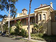
Petersham's houses are predominantly terrace houses, similar to those of Summer HillSummer Hill, New South Wales
Summer Hill is a suburb of Sydney, in the state of New South Wales, Australia. Summer Hill is located 8 kilometres west of the Sydney central business district, in the local government area of the Municipality of Ashfield....
and Stanmore
Stanmore, New South Wales
Stanmore is a suburb in the inner-west of Sydney, in New South Wales, Australia. Stanmore is located 6 kilometres south-west of the Sydney central business district and is part of the local government area of Marrickville Council.-History:...
on the north side of the railway station near Parramatta Road
Parramatta Road
.Parramatta Road is the major historical east-west artery of metropolitan Sydney, Australia, connecting the Sydney with Parramatta. It is the eastern-most part of the Great Western Highway. Much of its traffic has been diverted to modern expressways such as the M4 and the City West Link...
.
Culture
Local events include the annual Audley Street festival, which is a celebration of the suburb's Portuguese ties. Petersham is also home to one of the oldest bowling clubs in Australia; the Petersham Bowling Club.Demographics
According to the 2006 Census (Australian Bureau of StatisticsAustralian Bureau of Statistics
The Australian Bureau of Statistics is Australia's national statistical agency. It was created as the Commonwealth Bureau of Census and Statistics on 8 December 1905, when the Census and Statistics Act 1905 was given Royal assent. It had its beginnings in section 51 of the Constitution of Australia...
), the population of Petersham was 6639, 50% male and 50% female. The suburb has a high number of persons born in Southern Europe
Southern Europe
The term Southern Europe, at its most general definition, is used to mean "all countries in the south of Europe". However, the concept, at different times, has had different meanings, providing additional political, linguistic and cultural context to the definition in addition to the typical...
, most particularly Portugal
Portugal
Portugal , officially the Portuguese Republic is a country situated in southwestern Europe on the Iberian Peninsula. Portugal is the westernmost country of Europe, and is bordered by the Atlantic Ocean to the West and South and by Spain to the North and East. The Atlantic archipelagos of the...
and also Italy
Italy
Italy , officially the Italian Republic languages]] under the European Charter for Regional or Minority Languages. In each of these, Italy's official name is as follows:;;;;;;;;), is a unitary parliamentary republic in South-Central Europe. To the north it borders France, Switzerland, Austria and...
and Greece
Greece
Greece , officially the Hellenic Republic , and historically Hellas or the Republic of Greece in English, is a country in southeastern Europe....
. Known as "Little Portugal", Petersham has long been the main centre of Portuguese Australian
Portuguese Australian
Portuguese Australians are either Portuguese emigrated to or living in Australia, or native Australians with Portuguese ancestry.Despite their rather modest number compared to the Greek and Italian communities, Portuguese Australians form a very organized, self-conscious and active community in...
population in Sydney.
External links
- Marrickville Council - Petersham
- Crash of a Mosquito over suburbs of Sydney on 2 May 1945 Includes eyewitness accounts by children at the school.
- http://www.mccsydney.org Meteropolitan Community Church Sydney