
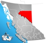
Peace River Regional District, British Columbia
Encyclopedia
The Peace River Regional District is a regional district in northeastern British Columbia
, Canada
. The regional district comprises seven municipalities and four electoral areas. Its member municipalities are the cities of Fort St. John
and Dawson Creek
, the district municipalities
of Tumbler Ridge
, Chetwynd
, Taylor
, and Hudson's Hope
, and the village
of Pouce Coupe
. Peace River also has four regional district electoral areas: B, C
, D
and E, six Indian reserves, and one Indian settlement
. The district's administrative centre is in Dawson Creek.
The regional district is characterized by rolling hills with grain and cattle farms. About 40% of the province's Agricultural Land Reserve
is situated within the regional district. The Peace River
flows west-to-east through the middle of the district. Its total land area is 119,200.1 km² (46,023.42 sq mi), the largest regional district in British Columbia in area. (The Stikine Region is larger, but is not technically a regional district.) The total population reported in the 2006 census
was 58,264 with 24,019 private dwellings, up from 55,080 people in 2001.
had pushed the Athapaskan-speaking Dunneza
into the BC portion of the Peace River Country
which pushed the fellow Athapaskan-speaking Sekani
into the foothills of the Rocky Mountains and beyond. European-Canadian explorers penetrated the area during the 19th–century by canoeing allow the Peace River and establishing trading posts at Fort St. John and Hudson's Hope. In 1883 the province gave the federal government control over 3500000 acres (14,164 km²) of land, anywhere north the Rocky Mountains, as part of a deal to extend a rail line to Vancouver. After settling land claims with Treaty 8
First Nations, creating the East Moberly Reserve, West Moberly Reserve, Halfway River Reserve, and the St. John Reserve, the government surveyed out its land as the Peace River Block
in 1907 and opened it to homesteading in 1912. Pioneer Hector Tremblay, and a few others, helped cut trails and opened stores and lodges to help in-coming settlers. The first community of these settlers was established at Pouce Coupe, around Tremblay's cabin. The land was granted back to the province in 1930 after conflicts regarding the water and mineral rights emerged.
The region grew slowly as agricultural settlements spread westward to the foothills of the Rocky Mountains and northward to the muskegs of the Liard. In 1932 Pouce Coupe became the first community in the region to incorporate as a village, followed by Dawson Creek in 1936 after a rail line was extended there from Alberta. The 1941 Canadian Census recorded 8,444 people in northeastern BC but a year later the Alaska Highway
was constructed by 10,000 US Army servicemen connecting Dawson Creek to Alaska via Fort Nelson. After the war and turning the highway over the province, the highway made it much easier to transport resources and agricultural products to rail lines and left Dawson Creek with 14-fold increase, and northeastern BC with a 2.5-fold increase, in population by 1956. Industrial development began with the provincially funded megaprojects which included the extension of transportation and utility infrastructure through the Rocky Mountains to Chetwynd and across the region and the construction of two hydroelectric dams at Hudson's Hope. An oil and gas industry developed and helped Fort St. John's population increase from 3,619 people in 1961 to 13,891 in 1981 surpassing Dawson Creek as the largest city. The last municipality in the region to incorporate was Tumbler Ridge which was built by the province in 1981 as an instant community to service two proposed coal mines. The region experienced little growth in the late-1980s and the population remained between 55,000 and 59,000 between 1992 and 2003. Since then, with a booming oil and gas industry, the population has gained over 5,500 people in three years.
or New Zealand's North Island
. The northern border along the 58th parallel north
was created when the PRLRD split to create the PRRD and the NRRD. To the east the Regional District borders with the Alberta counties of Greenview
, Grande Prairie
, Saddle Hills
, Clear Hills
, and Northern Lights at the BC-Alberta border. The southwestern border runs along the Rocky Mountains, beginning at Intersection Mountain then northwesterly along the summit of the Hart Ranges
to Williston Lake
and then northwesterly along the watersheds of the Manson
, Omineca
, Mesilinka, Finlay
, and Kechika
rivers.
Despite this large area, only about 64,272 people live there, giving the Regional District a population density of 0.54 people per km² (1.4 people/mi²). The people live almost exclusively in the agricultural areas in British Columbia's portion of the Peace River Country
straddling the Peace River. This biogeoclimatic zone, called the Boreal White and Black Spruce Zone, begins on the northern end of the Rockies and stretches into Alberta and the NRRD. Here, mean annual temperatures have ranged between -2.9 and 2 °C with annual precipitation averages between 330 and 570 mm.
According to BC's Ecoregion Classification System most of the Regional District is located in the Boreal Plains Ecoprovince of the Polar Ecodomain. This area is characterized by a continental climate
with low year-round precipitation. Moist Pacific air loses its precipitation over several mountain ranges before moving over the region, while Arctic air masses are uninterrupted. About 61% of BC's bird species and 46% of all breeding species occur in this ecoprovince. This ecoprovince is divided into four ecosections: the rolling uplands with few ridges and wide valleys of the Clear Hills and Halfway Plateau ecosections, the wide plains with deeply incised rivers of the Peace Lowland ecosection, and the rolling uplands and Rocky Mountain foothills of the Kiskatinaw Plateau ecosection. These ecosections have many wetlands, ponds, and slow-moving streams the area is a major migratory corridor for water- and shorebirds. Moose are the most common large mammal but mule and white-tailed deer, caribou, and elk are also very common. The ecosystem also supports Dall Sheep
, Black Bear
, Grizzly Bear
, and Gray Wolf
. There are few small mammal or reptile species. Fish species are restricted to freshwater fish like the Arctic grayling
, northern pike
, and slimy sculpin
. Major tree species include white spruce
, black spruce
, trembling aspen
, lodgepole pine
, balsam poplar
, tamarack, subalpine fir
, and paper birch
.
. Due to its population size relative to the other jurisdictions and the Board's weighted voting scheme, Fort St. John elects two directors and two alternates. The Board annually elects a chairperson from its membership. The Board convenes twice a month in the board room of Regional District office in Dawson Creek, although they occasionally meet in other member municipalities. Portions of these meetings are dedicated to the matters arising from the Peace River Hospital District which has the same membership and is responsible for raising capital for hospital expenditures.
The Electoral Area Directors Committee, consisting of the four electoral area directors, meet separately from the Board as a committee twice a month and addresses issues from their jurisdictions that do not require municipal participation. The board directors also form committees for wildlife, solid waste, rural budgets, and parks and recreation. The directors are joined with members of the public on committees for agricultural advisory, libraries, fire protection, community sewer systems, and emergency management. Directors can also be appointed to outside agencies to represent the interests of the Regional District.
The Regional District is covers portions of two provincial electoral areas: Peace River South
and Peace River North
. Peace River South is entirely with the Regional District and is represented by former Dawson Creek mayor Blair Lekstrom in the Legislative Assembly
since 2001. Peace River North, represented since 1991 by the Minister of Energy, Mines and Petroleum Resources Richard Neufeld, includes the north half of the Regional District as well as the entire Northern Rockies Regional District. The Regional District is entirely with the federal riding of Prince George—Peace River
and has been represented in the Canadian House of Commons
by Jay Hill
since 1993.
British Columbia
British Columbia is the westernmost of Canada's provinces and is known for its natural beauty, as reflected in its Latin motto, Splendor sine occasu . Its name was chosen by Queen Victoria in 1858...
, Canada
Canada
Canada is a North American country consisting of ten provinces and three territories. Located in the northern part of the continent, it extends from the Atlantic Ocean in the east to the Pacific Ocean in the west, and northward into the Arctic Ocean...
. The regional district comprises seven municipalities and four electoral areas. Its member municipalities are the cities of Fort St. John
Fort St. John, British Columbia
The City of Fort St. John is a city in northeastern British Columbia, Canada. A member municipality of the Peace River Regional District, the city covers an area of about 22 km² with 22,000 residents . Located at Mile 47, it is one of the largest cities along the Alaska Highway. Originally...
and Dawson Creek
Dawson Creek, British Columbia
Dawson Creek is a small city in northeastern British Columbia, Canada. The municipality of had a population of 11,529 in 2009. Dawson Creek derives its name from the creek of the same name that runs through the community. The creek was named after George Mercer Dawson by a member of his land...
, the district municipalities
District municipality
A district municipality is a designation for a class of municipalities found in several locations, including Canada, Lithuania, and South Africa.-Usage in British Columbia:...
of Tumbler Ridge
Tumbler Ridge, British Columbia
The District Municipality of Tumbler Ridge is a small town in the foothills of the Canadian Rockies in northeastern British Columbia, Canada, and a member municipality of the Peace River Regional District. The municipality of , with its population of 2,454 people, incorporates a townsite and a...
, Chetwynd
Chetwynd, British Columbia
The District of Chetwynd is a town located on the foothills of the Rocky Mountains in northeastern British Columbia, Canada. Situated on an ancient floodplain, it is the first town eastbound travellers encounter after emerging from the Rockies along Highway 97 and acts as the gateway to the Peace...
, Taylor
Taylor, British Columbia
The District of Taylor is a small town in northeastern British Columbia, Canada, located on mile 36 of the Alaska Highway. Taylor, a member municipality of the Peace River Regional District, covers an area of about 17 km² with 1,380 residents. As it is just south of the much larger city of...
, and Hudson's Hope
Hudson's Hope, British Columbia
Hudson's Hope is a district municipality in northeastern British Columbia, Canada, in the Peace River Regional District. It covers an area of with a population of 1,157 people. Having been first settled in 1805, it is the third oldest community in the province, although it was not incorporated...
, and the village
Village
A village is a clustered human settlement or community, larger than a hamlet with the population ranging from a few hundred to a few thousand , Though often located in rural areas, the term urban village is also applied to certain urban neighbourhoods, such as the West Village in Manhattan, New...
of Pouce Coupe
Pouce Coupe, British Columbia
The Village of Pouce Coupe is a small town in northeastern British Columbia, Canada, and a member municipality of the Peace River Regional District. It was originally named 'Pouskapie's Prairie', after the name of the local native band chief...
. Peace River also has four regional district electoral areas: B, C
Peace River C, British Columbia
Peace River C is a regional district electoral area in the Peace River Regional District in northeastern British Columbia, Canada. The electoral covers the area around Fort St. John...
, D
Peace River D, British Columbia
Peace River D is a regional district electoral area in the Peace River Regional District in northeastern British Columbia, Canada. It includes a large area in the southeast part of the district, generally south of the Peace River along the Alberta border....
and E, six Indian reserves, and one Indian settlement
Indian settlement
An Indian settlement is a census subdivision outlined by the Canadian government Department of Indian and Northern Affairs Canada for census purposes. These areas have at least 10 Indian people who live, more or less, permanently in the given area...
. The district's administrative centre is in Dawson Creek.
The regional district is characterized by rolling hills with grain and cattle farms. About 40% of the province's Agricultural Land Reserve
Agricultural Land Reserve
The Agricultural Land Reserve is a collection of land in the Canadian province of British Columbia in which agriculture is recognized as the priority use. Farming is encouraged and non-agricultural uses are controlled. In total, the ALR covers approximately and includes private and public lands...
is situated within the regional district. The Peace River
Peace River (Canada)
The Peace River is a river in Canada that originates in the Rocky Mountains of northern British Columbia and flows to the northeast through northern Alberta. The Peace River flows into the Slave River, a tributary of the Mackenzie River. The Mackenzie is the 12th longest river in the world,...
flows west-to-east through the middle of the district. Its total land area is 119,200.1 km² (46,023.42 sq mi), the largest regional district in British Columbia in area. (The Stikine Region is larger, but is not technically a regional district.) The total population reported in the 2006 census
Canada 2006 Census
The Canada 2006 Census was a detailed enumeration of the Canadian population. Census day was May 16, 2006. The next census following will be the 2011 Census. Canada's total population enumerated by the 2006 census was 31,612,897...
was 58,264 with 24,019 private dwellings, up from 55,080 people in 2001.
Jurisdictions
| Member | Population | Directors | Weighted Vote |
|---|---|---|---|
| City of Fort St. John Fort St. John, British Columbia The City of Fort St. John is a city in northeastern British Columbia, Canada. A member municipality of the Peace River Regional District, the city covers an area of about 22 km² with 22,000 residents . Located at Mile 47, it is one of the largest cities along the Alaska Highway. Originally... |
22,000 | 2 | 6 |
| City of Dawson Creek Dawson Creek, British Columbia Dawson Creek is a small city in northeastern British Columbia, Canada. The municipality of had a population of 11,529 in 2009. Dawson Creek derives its name from the creek of the same name that runs through the community. The creek was named after George Mercer Dawson by a member of his land... |
10,994 | 1 | 4 |
| District of Chetwynd Chetwynd, British Columbia The District of Chetwynd is a town located on the foothills of the Rocky Mountains in northeastern British Columbia, Canada. Situated on an ancient floodplain, it is the first town eastbound travellers encounter after emerging from the Rockies along Highway 97 and acts as the gateway to the Peace... |
2,633 | 1 | 1 |
| District of Tumbler Ridge Tumbler Ridge, British Columbia The District Municipality of Tumbler Ridge is a small town in the foothills of the Canadian Rockies in northeastern British Columbia, Canada, and a member municipality of the Peace River Regional District. The municipality of , with its population of 2,454 people, incorporates a townsite and a... |
2,454 | 1 | 1 |
| District of Taylor Taylor, British Columbia The District of Taylor is a small town in northeastern British Columbia, Canada, located on mile 36 of the Alaska Highway. Taylor, a member municipality of the Peace River Regional District, covers an area of about 17 km² with 1,380 residents. As it is just south of the much larger city of... |
1,384 | 1 | 1 |
| District of Hudson's Hope Hudson's Hope, British Columbia Hudson's Hope is a district municipality in northeastern British Columbia, Canada, in the Peace River Regional District. It covers an area of with a population of 1,157 people. Having been first settled in 1805, it is the third oldest community in the province, although it was not incorporated... |
1,012 | 1 | 1 |
| Village of Pouce Coupe Pouce Coupe, British Columbia The Village of Pouce Coupe is a small town in northeastern British Columbia, Canada, and a member municipality of the Peace River Regional District. It was originally named 'Pouskapie's Prairie', after the name of the local native band chief... |
739 | 1 | 1 |
| Electoral Area “B” | 5,538 | 1 | 2 |
| Electoral Area “C” | 6,350 | 1 | 2 |
| Electoral Area “D” | 5,749 | 1 | 2 |
| Electoral Area “E” | 3,031 | 1 | 2 |
| Total | 58,264 | 12 | 23 |
History
Westward expansion during the With 18th and 19th centuries pushed First Nation groups westward and into competition with each other for resources. The Algonkian-speaking CreeCree
The Cree are one of the largest groups of First Nations / Native Americans in North America, with 200,000 members living in Canada. In Canada, the major proportion of Cree live north and west of Lake Superior, in Ontario, Manitoba, Saskatchewan, Alberta and the Northwest Territories, although...
had pushed the Athapaskan-speaking Dunneza
Dunneza
The Dane-zaa are a First Nation of the large Athapaskan language group; their traditional territory is around the Peace River of the provinces of Alberta and British Columbia, Canada...
into the BC portion of the Peace River Country
Peace River Country
The Peace River Country is an aspen parkland region around the Peace River in Canada. It spans from northwestern Alberta to the Rocky Mountains in northeastern British Columbia, where the region is also referred to as the Peace River Block.- Geography :The Peace River Country includes the...
which pushed the fellow Athapaskan-speaking Sekani
Sekani
Sekani is the name of an Athabaskan First Nations people in the Northern Interior of British Columbia. Their territory includes the Finlay and Parsnip River drainages of the Rocky Mountain Trench. The neighbors of the Sekani are the Babine to the west, Dakelh to the south, Dunneza to the east, and...
into the foothills of the Rocky Mountains and beyond. European-Canadian explorers penetrated the area during the 19th–century by canoeing allow the Peace River and establishing trading posts at Fort St. John and Hudson's Hope. In 1883 the province gave the federal government control over 3500000 acres (14,164 km²) of land, anywhere north the Rocky Mountains, as part of a deal to extend a rail line to Vancouver. After settling land claims with Treaty 8
Treaty 8
Treaty 8 was an agreement signed on June 21, 1899, between Queen Victoria and various First Nations of the Lesser Slave Lake area. The Treaty was signed just south of present-day Grouard, Alberta.-Treaty:...
First Nations, creating the East Moberly Reserve, West Moberly Reserve, Halfway River Reserve, and the St. John Reserve, the government surveyed out its land as the Peace River Block
Peace River Block
The Peace River Block is an area of land located in northeastern British Columbia, in the Peace River Country. In exchange for building a rail line across Canada to British Columbia the Canadian Pacific Railway was given a belt, on each side of the rail, of land...
in 1907 and opened it to homesteading in 1912. Pioneer Hector Tremblay, and a few others, helped cut trails and opened stores and lodges to help in-coming settlers. The first community of these settlers was established at Pouce Coupe, around Tremblay's cabin. The land was granted back to the province in 1930 after conflicts regarding the water and mineral rights emerged.
The region grew slowly as agricultural settlements spread westward to the foothills of the Rocky Mountains and northward to the muskegs of the Liard. In 1932 Pouce Coupe became the first community in the region to incorporate as a village, followed by Dawson Creek in 1936 after a rail line was extended there from Alberta. The 1941 Canadian Census recorded 8,444 people in northeastern BC but a year later the Alaska Highway
Alaska Highway
The Alaska Highway was constructed during World War II for the purpose of connecting the contiguous U.S. to Alaska through Canada. It begins at the junction with several Canadian highways in Dawson Creek, British Columbia and runs to Delta Junction, Alaska, via Whitehorse, Yukon...
was constructed by 10,000 US Army servicemen connecting Dawson Creek to Alaska via Fort Nelson. After the war and turning the highway over the province, the highway made it much easier to transport resources and agricultural products to rail lines and left Dawson Creek with 14-fold increase, and northeastern BC with a 2.5-fold increase, in population by 1956. Industrial development began with the provincially funded megaprojects which included the extension of transportation and utility infrastructure through the Rocky Mountains to Chetwynd and across the region and the construction of two hydroelectric dams at Hudson's Hope. An oil and gas industry developed and helped Fort St. John's population increase from 3,619 people in 1961 to 13,891 in 1981 surpassing Dawson Creek as the largest city. The last municipality in the region to incorporate was Tumbler Ridge which was built by the province in 1981 as an instant community to service two proposed coal mines. The region experienced little growth in the late-1980s and the population remained between 55,000 and 59,000 between 1992 and 2003. Since then, with a booming oil and gas industry, the population has gained over 5,500 people in three years.
Geography and climate
The Regional District is the largest in the province, comprising 13% of its area. At 119,200 km² (46,023 mi²) it is similar in area to the American state of PennsylvaniaPennsylvania
The Commonwealth of Pennsylvania is a U.S. state that is located in the Northeastern and Mid-Atlantic regions of the United States. The state borders Delaware and Maryland to the south, West Virginia to the southwest, Ohio to the west, New York and Ontario, Canada, to the north, and New Jersey to...
or New Zealand's North Island
North Island
The North Island is one of the two main islands of New Zealand, separated from the much less populous South Island by Cook Strait. The island is in area, making it the world's 14th-largest island...
. The northern border along the 58th parallel north
58th parallel north
The 58th parallel north is a circle of latitude that is 58 degrees north of the Earth's equatorial plane. It crosses Europe, Asia, the Pacific Ocean, North America, and the Atlantic Ocean....
was created when the PRLRD split to create the PRRD and the NRRD. To the east the Regional District borders with the Alberta counties of Greenview
Greenview No. 16, Alberta
The Municipal District of Greenview No. 16 is a municipal district in northwest Alberta, Canada.It covers the full extent of Census Division 18. The municipal seat is in Valleyview.- Demographics :...
, Grande Prairie
Grande Prairie County No. 1, Alberta
The County of Grande Prairie No. 1 is a municipal district in northwestern Alberta, Canada in Census Division No. 19.It is bounded on the south by the Wapiti River, on the east by the Smoky River and on the west by the province of British Columbia....
, Saddle Hills
Saddle Hills County, Alberta
Saddle Hills County is a municipal district situated in the Central Peace Country of west-northern Alberta, Canada. It is located approximately north-west of Edmonton and north of Grande Prairie....
, Clear Hills
Clear Hills County, Alberta
Clear Hills County is a municipal district in north western Alberta, Canada. It is located in Census Division 17.On Jan 01, 2006, the name was changed from Municipal District of Clear Hills No...
, and Northern Lights at the BC-Alberta border. The southwestern border runs along the Rocky Mountains, beginning at Intersection Mountain then northwesterly along the summit of the Hart Ranges
Hart Ranges
The Hart Ranges are one of the main geographic subdivisions of the Canadian Rockies and are the main part of the area that is meant by the Northern Rockies, although the much larger Muskwa Ranges to the north are more deserving of that term — but also much more inaccessible and much less...
to Williston Lake
Williston Lake
Williston Lake is a reservoir created by the W. A. C. Bennett Dam and is located in the Northern Interior of British Columbia, Canada.-Geography:...
and then northwesterly along the watersheds of the Manson
Manson River
Manson River is a river located in the Omineca Country region of British Columbia. It flows north into Manson Arm, Williston Lake. The river is located south of Germansen Landing. It was first known as Manson Creek and was discovered in 1871 by Robert Howell. The river has been mined using...
, Omineca
Omineca River
Omineca River is a river in northern British Columbia, Canada. It flows into the Williston Lake, and is part of the Peace River basin. It was originally a tributary of the Finlay River before the creation of Lake Williston.-References:...
, Mesilinka, Finlay
Finlay River
The Finlay River is a 402 km long river in north-central British Columbia flowing north and thence south from Thutade Lake in the Omineca Mountains to Williston Lake, the impounded waters of the Peace River formed by the completion of the W.A.C. Bennett Dam in 1968. Prior to this, the Finlay...
, and Kechika
Kechika River
The Kechika River also historically known as Black's River, is a tributary of the Liard River, located in northern British Columbia, Canada. The river rises at the Sifton Pass and flows northwest and then east 230 kilometres to join with the Liard River near Fireside, British Columbia...
rivers.
Despite this large area, only about 64,272 people live there, giving the Regional District a population density of 0.54 people per km² (1.4 people/mi²). The people live almost exclusively in the agricultural areas in British Columbia's portion of the Peace River Country
Peace River Country
The Peace River Country is an aspen parkland region around the Peace River in Canada. It spans from northwestern Alberta to the Rocky Mountains in northeastern British Columbia, where the region is also referred to as the Peace River Block.- Geography :The Peace River Country includes the...
straddling the Peace River. This biogeoclimatic zone, called the Boreal White and Black Spruce Zone, begins on the northern end of the Rockies and stretches into Alberta and the NRRD. Here, mean annual temperatures have ranged between -2.9 and 2 °C with annual precipitation averages between 330 and 570 mm.
According to BC's Ecoregion Classification System most of the Regional District is located in the Boreal Plains Ecoprovince of the Polar Ecodomain. This area is characterized by a continental climate
Continental climate
Continental climate is a climate characterized by important annual variation in temperature due to the lack of significant bodies of water nearby...
with low year-round precipitation. Moist Pacific air loses its precipitation over several mountain ranges before moving over the region, while Arctic air masses are uninterrupted. About 61% of BC's bird species and 46% of all breeding species occur in this ecoprovince. This ecoprovince is divided into four ecosections: the rolling uplands with few ridges and wide valleys of the Clear Hills and Halfway Plateau ecosections, the wide plains with deeply incised rivers of the Peace Lowland ecosection, and the rolling uplands and Rocky Mountain foothills of the Kiskatinaw Plateau ecosection. These ecosections have many wetlands, ponds, and slow-moving streams the area is a major migratory corridor for water- and shorebirds. Moose are the most common large mammal but mule and white-tailed deer, caribou, and elk are also very common. The ecosystem also supports Dall Sheep
Dall Sheep
The Dall sheep , Ovis dalli, is a species of sheep native to northwestern North America, ranging from white to slate brown in color and having curved yellowish brown horns...
, Black Bear
American black bear
The American black bear is a medium-sized bear native to North America. It is the continent's smallest and most common bear species. Black bears are omnivores, with their diets varying greatly depending on season and location. They typically live in largely forested areas, but do leave forests in...
, Grizzly Bear
Grizzly Bear
The grizzly bear , also known as the silvertip bear, the grizzly, or the North American brown bear, is a subspecies of brown bear that generally lives in the uplands of western North America...
, and Gray Wolf
Gray Wolf
The gray wolf , also known as the wolf, is the largest extant wild member of the Canidae family...
. There are few small mammal or reptile species. Fish species are restricted to freshwater fish like the Arctic grayling
Arctic grayling
Arctic grayling is a species of freshwater fish in the salmon family of order Salmoniformes. It comprises five subspecies native to the Nearctic and Palearctic ecozones. T. a. arcticus is widespread throughout the Arctic and Pacific drainages in Canada, Alaska, and Siberia, as well as the upper...
, northern pike
Northern Pike
The northern pike , is a species of carnivorous fish of the genus Esox...
, and slimy sculpin
Slimy Sculpin
The slimy sculpin, Cottus cognatus, is a freshwater species of fish that inhabits cool, rocky streams, rivers and lakes throughout northern North America and eastern Siberia. The slimy sculpin is found in freshwater and sometimes brackish water in areas with rocky or gravel type bottoms...
. Major tree species include white spruce
White Spruce
Picea glauca is a species of spruce native to boreal forests in the north of North America, from central Alaska east to Newfoundland, and south to northern Montana, Minnesota, Wisconsin, Michigan, upstate New York, Vermont, New Hampshire, and Maine; there is also an isolated population in the...
, black spruce
Black Spruce
Picea mariana is a species of spruce native to northern North America, from Newfoundland west to Alaska, and south to northern New York, Minnesota and central British Columbia...
, trembling aspen
Trembling aspen
Trembling aspen is the popular name for either*Populus tremuloides *Populus tremula...
, lodgepole pine
Lodgepole Pine
Lodgepole Pine, Pinus contorta, also known as Shore Pine, is a common tree in western North America. Like all pines, it is evergreen.-Subspecies:...
, balsam poplar
Balsam poplar
The balsam poplars — also known as Populus sect. Tacamahaca — are a group of about 10 species of poplars, indigenous to North America and eastern Asia, distinguished by the balsam scent of their buds, the whitish undersides of their leaves, and the leaf petiole being round in cross-section...
, tamarack, subalpine fir
Subalpine Fir
The Subalpine Fir or Rocky Mountain Fir is a western North American fir, native to the mountains of Yukon, British Columbia and western Alberta in Canada; southeastern Alaska, Washington, Oregon, Idaho, western Montana, Wyoming, Utah, Colorado, New Mexico, Arizona, northeastern Nevada, and the...
, and paper birch
Paper Birch
Betula papyrifera is a species of birch native to northern North America.-Description:...
.
Government and politics
The Regional District is governed by a board of 11 directors. The Board consists of one representative from each municipality, usually the mayors, and one director from each electoral area. The municipal representatives, and their alternates, are elected by the municipal councils and the electoral area directors are elected for 3 year terms by their constituents during province-wide local electionsBritish Columbia municipal elections, 2005
The Canadian province of British Columbia held its triannual municipal elections on November 19, 2005. Voters in each of BC's 157 municipalities elected mayors and councillors, and rural voters elected directors for their regional district electoral area...
. Due to its population size relative to the other jurisdictions and the Board's weighted voting scheme, Fort St. John elects two directors and two alternates. The Board annually elects a chairperson from its membership. The Board convenes twice a month in the board room of Regional District office in Dawson Creek, although they occasionally meet in other member municipalities. Portions of these meetings are dedicated to the matters arising from the Peace River Hospital District which has the same membership and is responsible for raising capital for hospital expenditures.
The Electoral Area Directors Committee, consisting of the four electoral area directors, meet separately from the Board as a committee twice a month and addresses issues from their jurisdictions that do not require municipal participation. The board directors also form committees for wildlife, solid waste, rural budgets, and parks and recreation. The directors are joined with members of the public on committees for agricultural advisory, libraries, fire protection, community sewer systems, and emergency management. Directors can also be appointed to outside agencies to represent the interests of the Regional District.
The Regional District is covers portions of two provincial electoral areas: Peace River South
Peace River South
Peace River South is a provincial electoral district for the Legislative Assembly of British Columbia, Canada. It was created under the name South Peace River by the Constitution Amendment Act, 1955, which split the old riding of Peace River into northern and southern portions for the 1956 B.C....
and Peace River North
Peace River North
Peace River North is a provincial electoral district for the Legislative Assembly of British Columbia, Canada. It was created under the name North Peace River by the Constitution Amendment Act, 1955, which split the old riding of Peace River into northern and southern portions for the 1956 B.C....
. Peace River South is entirely with the Regional District and is represented by former Dawson Creek mayor Blair Lekstrom in the Legislative Assembly
Legislative Assembly of British Columbia
The Legislative Assembly of British Columbia is one of two components of the Parliament of British Columbia, the provincial parliament ....
since 2001. Peace River North, represented since 1991 by the Minister of Energy, Mines and Petroleum Resources Richard Neufeld, includes the north half of the Regional District as well as the entire Northern Rockies Regional District. The Regional District is entirely with the federal riding of Prince George—Peace River
Prince George—Peace River
Prince George—Peace River is a federal electoral district in British Columbia, Canada, that has been represented in the Canadian House of Commons since 1968.-Geography:...
and has been represented in the Canadian House of Commons
Canadian House of Commons
The House of Commons of Canada is a component of the Parliament of Canada, along with the Sovereign and the Senate. The House of Commons is a democratically elected body, consisting of 308 members known as Members of Parliament...
by Jay Hill
Jay Hill
Jay D. Hill PC is a former Canadian politician and member of the Conservative Party of Canada. He was the Member of Parliament for the riding of Prince George—Peace River from 1993 until his retirement in 2010. He also served as Government House Leader in the Canadian House of Commons during his...
since 1993.