
Williston Lake
Encyclopedia
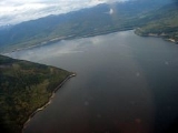
Williston Lake is a reservoir
created by the W. A. C. Bennett Dam
and is located in the Northern Interior of British Columbia
, Canada
.
 The lake fills the basin of the upper Peace River
, backing into the Rocky Mountain Trench
which is where the Parsnip and Finlay met at Finlay Forks to form the Peace. The lake includes three reaches
, the Peace Reach (formerly the Peace Canyon), and the Parsnip and Finlay Reaches, which are the lowermost basins of those rivers, and covers a total area of 1761 km² (679.9 sq mi), being the largest lake in British Columbia and the seventh largest reservoir in the world.
The reservoir is fed by the Finlay
, Omineca
, Ingenika, Ospika
, Parsnip
, Manson
, Nation
and Nabesche Rivers and by Clearwater Creek, Carbon Creek, and other smaller creeks.
Several provincial park
s are maintained on the shore of the lake, including Muscovite Lakes Provincial Park
, Butler Ridge Provincial Park
, Heather-Dina Lakes Provincial Park
and Ed Bird-Estella Provincial Park
.
by the building of the W. A. C. Bennett Dam
on the Peace River
, which flooded the aboriginal-territorial home of the Tsay Keh Dene
band.
The reservoir was named after the Honourable Ray Gillis Williston, at the time the Minister of Lands, Forests and Water Resources.

Reservoir
A reservoir , artificial lake or dam is used to store water.Reservoirs may be created in river valleys by the construction of a dam or may be built by excavation in the ground or by conventional construction techniques such as brickwork or cast concrete.The term reservoir may also be used to...
created by the W. A. C. Bennett Dam
W. A. C. Bennett Dam
The W. A. C. Bennett Dam is a large hydroelectric earthfill dam on the Peace River in northern British Columbia, Canada. The dam, located 19 kilometres west of Hudson's Hope, and 85 kilometres northwest of Chetwynd, is named after the late former premier W. A. C. Bennett, and came on-line in 1968...
and is located in the Northern Interior of British Columbia
British Columbia Interior
The British Columbia Interior or BC Interior or Interior of British Columbia, usually referred to only as the Interior, is one of the three main regions of the Canadian province of British Columbia, the other two being the Lower Mainland, which comprises the overlapping areas of Greater Vancouver...
, Canada
Canada
Canada is a North American country consisting of ten provinces and three territories. Located in the northern part of the continent, it extends from the Atlantic Ocean in the east to the Pacific Ocean in the west, and northward into the Arctic Ocean...
.
Geography
Peace River (Canada)
The Peace River is a river in Canada that originates in the Rocky Mountains of northern British Columbia and flows to the northeast through northern Alberta. The Peace River flows into the Slave River, a tributary of the Mackenzie River. The Mackenzie is the 12th longest river in the world,...
, backing into the Rocky Mountain Trench
Rocky Mountain Trench
The Rocky Mountain Trench, or the Trench or The Valley of a Thousand Peaks, is a large valley in the northern part of the Rocky Mountains. It is both visually and cartographically a striking physiographic feature extending approximately from Flathead Lake, Montana, to the Liard River, just south...
which is where the Parsnip and Finlay met at Finlay Forks to form the Peace. The lake includes three reaches
Reach (geography)
A reach in geography can mean several things. Most generally, a reach is any length of a stream between any two points. The points may be selected for any reason, such as gauging stations, river miles, natural features, and topography. They may be arbitrary or vague.A reach may also be an expanse,...
, the Peace Reach (formerly the Peace Canyon), and the Parsnip and Finlay Reaches, which are the lowermost basins of those rivers, and covers a total area of 1761 km² (679.9 sq mi), being the largest lake in British Columbia and the seventh largest reservoir in the world.
The reservoir is fed by the Finlay
Finlay River
The Finlay River is a 402 km long river in north-central British Columbia flowing north and thence south from Thutade Lake in the Omineca Mountains to Williston Lake, the impounded waters of the Peace River formed by the completion of the W.A.C. Bennett Dam in 1968. Prior to this, the Finlay...
, Omineca
Omineca River
Omineca River is a river in northern British Columbia, Canada. It flows into the Williston Lake, and is part of the Peace River basin. It was originally a tributary of the Finlay River before the creation of Lake Williston.-References:...
, Ingenika, Ospika
Ospika River
The Ospika River is a river in the Northern Interior of British Columbia, Canada, rising in the Northern Rocky Mountains to the north of Lake Williston and flowing south to join that lake in the lower end of its Finlay Reach. Before the creation of that lake by the building of WAC Bennett Dam, it...
, Parsnip
Parsnip River
The Parsnip River is a 240 km long river in central British Columbia, Canada. It flows generally north-westward from the Parsnip Glacier in the Hart Ranges to the Parsnip Reach of Williston Lake, formed by the impounding of the waters of the Peace River by the W.A.C. Bennett Dam in 1968...
, Manson
Manson River
Manson River is a river located in the Omineca Country region of British Columbia. It flows north into Manson Arm, Williston Lake. The river is located south of Germansen Landing. It was first known as Manson Creek and was discovered in 1871 by Robert Howell. The river has been mined using...
, Nation
Nation River
Nation River may refer to:* South Nation River in Ontario* Petite-Nation River in Quebec* Nation River , a tributary of the Peace River in British Columbia...
and Nabesche Rivers and by Clearwater Creek, Carbon Creek, and other smaller creeks.
Several provincial park
Provincial park
A provincial park is a park under the management of a provincial or territorial government in Canada.While provincial parks are not the same as national parks, their workings are very similar...
s are maintained on the shore of the lake, including Muscovite Lakes Provincial Park
Muscovite Lakes Provincial Park
Muscovite Lakes Provincial Park is a provincial park in British Columbia, Canada, located on the western shore of Lake Williston 125 km north of Mackenzie.-References:*...
, Butler Ridge Provincial Park
Butler Ridge Provincial Park
Butler Ridge Provincial Park is a provincial park in British Columbia, Canada. Located on the northern shore of the Peach Reach arm of Williston Lake, 20 km northwest of Hudson's Hope, the park covers an area of 6,694 ha...
, Heather-Dina Lakes Provincial Park
Heather-Dina Lakes Provincial Park
Heather-Dina Lakes Provincial Park is a provincial park in British Columbia, Canada. The Heather-Dina park, which is named after two lakes in the park, features mature, mixed forest with many small lakes. Facilities are quite limited compared to other parks in British Columbia. A primitive...
and Ed Bird-Estella Provincial Park
Ed Bird-Estella Provincial Park
Ed Bird – Estella Lakes Provincial Park is a provincial park in British Columbia, Canada.- History and conservation :This park was traditionally used by First Nations people....
.
Tributaries
The following rivers empty into the Williston Reservoir:- Finlay RiverFinlay RiverThe Finlay River is a 402 km long river in north-central British Columbia flowing north and thence south from Thutade Lake in the Omineca Mountains to Williston Lake, the impounded waters of the Peace River formed by the completion of the W.A.C. Bennett Dam in 1968. Prior to this, the Finlay...
- Omineca RiverOmineca RiverOmineca River is a river in northern British Columbia, Canada. It flows into the Williston Lake, and is part of the Peace River basin. It was originally a tributary of the Finlay River before the creation of Lake Williston.-References:...
- Ingenika River
- Ospika River
- Parsnip RiverParsnip RiverThe Parsnip River is a 240 km long river in central British Columbia, Canada. It flows generally north-westward from the Parsnip Glacier in the Hart Ranges to the Parsnip Reach of Williston Lake, formed by the impounding of the waters of the Peace River by the W.A.C. Bennett Dam in 1968...
- Manson River
- Nation River
- Clearwater Creek
- Nabesche River
- Carbon Creek
History
Williston Lake was created in 19681968 in Canada
-Incumbents:*Monarch – Elizabeth II*Governor General – Roland Michener*Prime Minister – Lester B. Pearson then Pierre Trudeau*Premier of Alberta – Ernest Manning then Harry Strom*Premier of British Columbia – W.A.C...
by the building of the W. A. C. Bennett Dam
W. A. C. Bennett Dam
The W. A. C. Bennett Dam is a large hydroelectric earthfill dam on the Peace River in northern British Columbia, Canada. The dam, located 19 kilometres west of Hudson's Hope, and 85 kilometres northwest of Chetwynd, is named after the late former premier W. A. C. Bennett, and came on-line in 1968...
on the Peace River
Peace River (Canada)
The Peace River is a river in Canada that originates in the Rocky Mountains of northern British Columbia and flows to the northeast through northern Alberta. The Peace River flows into the Slave River, a tributary of the Mackenzie River. The Mackenzie is the 12th longest river in the world,...
, which flooded the aboriginal-territorial home of the Tsay Keh Dene
Tsay Keh Dene
Stay Keh Dene, meaning "people of the rocks" in the Sekani language, may mean:*the Sekani people of northern British Columbia, Canada*the Tsay Keh Dene First Nation, the band government of the Sekani people*the Sekani language...
band.
The reservoir was named after the Honourable Ray Gillis Williston, at the time the Minister of Lands, Forests and Water Resources.
External links
- BC Hydro. Williston Reservoir
- BC Hydro. Peace-Williston Fish and Wildlife Compensation Program