
Pouce Coupe, British Columbia
Encyclopedia
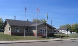
The Village of Pouce Coupe (French
French language
French is a Romance language spoken as a first language in France, the Romandy region in Switzerland, Wallonia and Brussels in Belgium, Monaco, the regions of Quebec and Acadia in Canada, and by various communities elsewhere. Second-language speakers of French are distributed throughout many parts...
for "cut- thumb") is a small town
Town
A town is a human settlement larger than a village but smaller than a city. The size a settlement must be in order to be called a "town" varies considerably in different parts of the world, so that, for example, many American "small towns" seem to British people to be no more than villages, while...
in northeastern British Columbia
British Columbia
British Columbia is the westernmost of Canada's provinces and is known for its natural beauty, as reflected in its Latin motto, Splendor sine occasu . Its name was chosen by Queen Victoria in 1858...
, Canada
Canada
Canada is a North American country consisting of ten provinces and three territories. Located in the northern part of the continent, it extends from the Atlantic Ocean in the east to the Pacific Ocean in the west, and northward into the Arctic Ocean...
, and a member municipality
Municipality
A municipality is essentially an urban administrative division having corporate status and usually powers of self-government. It can also be used to mean the governing body of a municipality. A municipality is a general-purpose administrative subdivision, as opposed to a special-purpose district...
of the Peace River Regional District
Peace River Regional District, British Columbia
The Peace River Regional District is a regional district in northeastern British Columbia, Canada. The regional district comprises seven municipalities and four electoral areas. Its member municipalities are the cities of Fort St. John and Dawson Creek, the district municipalities of Tumbler Ridge,...
. It was originally named 'Pouskapie's Prairie', after the name of the local native band chief. The 2.06 km² (0.80 mi²) municipality is home to 739 residents.
The community was settled by Europe
Europe
Europe is, by convention, one of the world's seven continents. Comprising the westernmost peninsula of Eurasia, Europe is generally 'divided' from Asia to its east by the watershed divides of the Ural and Caucasus Mountains, the Ural River, the Caspian and Black Seas, and the waterways connecting...
an immigrant Hector Tremblay in 1898. Mr. Tremblay, being a French speaking individual, translated 'Pouskapie's Prairie' into the nearest French words of similar sound. Pouce Coupe is approximately 10 km (6.2 mi) southeast of Dawson Creek
Dawson Creek, British Columbia
Dawson Creek is a small city in northeastern British Columbia, Canada. The municipality of had a population of 11,529 in 2009. Dawson Creek derives its name from the creek of the same name that runs through the community. The creek was named after George Mercer Dawson by a member of his land...
along Highway 2. It is approximately 35 km (21.7 mi) northwest of the Alberta
Alberta
Alberta is a province of Canada. It had an estimated population of 3.7 million in 2010 making it the most populous of Canada's three prairie provinces...
border along Highway 2. The village is at an elevation of 655 metres (2168 ft) in the Peace River Country
Peace River Country
The Peace River Country is an aspen parkland region around the Peace River in Canada. It spans from northwestern Alberta to the Rocky Mountains in northeastern British Columbia, where the region is also referred to as the Peace River Block.- Geography :The Peace River Country includes the...
.
Pouce Coupe's main industries today are petroleum
Petroleum
Petroleum or crude oil is a naturally occurring, flammable liquid consisting of a complex mixture of hydrocarbons of various molecular weights and other liquid organic compounds, that are found in geologic formations beneath the Earth's surface. Petroleum is recovered mostly through oil drilling...
, agriculture
Agriculture
Agriculture is the cultivation of animals, plants, fungi and other life forms for food, fiber, and other products used to sustain life. Agriculture was the key implement in the rise of sedentary human civilization, whereby farming of domesticated species created food surpluses that nurtured the...
, and tourism
Tourism
Tourism is travel for recreational, leisure or business purposes. The World Tourism Organization defines tourists as people "traveling to and staying in places outside their usual environment for not more than one consecutive year for leisure, business and other purposes".Tourism has become a...
. Popular recreational activities in the area include cross-country skiing
Cross-country skiing
Cross-country skiing is a winter sport in which participants propel themselves across snow-covered terrain using skis and poles...
, snowmobiling
Snowmobile
A snowmobile, also known in some places as a snowmachine, or sled,is a land vehicle for winter travel on snow. Designed to be operated on snow and ice, they require no road or trail. Design variations enable some machines to operate in deep snow or forests; most are used on open terrain, including...
, fishing
Fishing
Fishing is the activity of trying to catch wild fish. Fish are normally caught in the wild. Techniques for catching fish include hand gathering, spearing, netting, angling and trapping....
, hiking
Hiking
Hiking is an outdoor activity which consists of walking in natural environments, often in mountainous or other scenic terrain. People often hike on hiking trails. It is such a popular activity that there are numerous hiking organizations worldwide. The health benefits of different types of hiking...
, and hunting
Hunting
Hunting is the practice of pursuing any living thing, usually wildlife, for food, recreation, or trade. In present-day use, the term refers to lawful hunting, as distinguished from poaching, which is the killing, trapping or capture of the hunted species contrary to applicable law...
. The Village claims to be The Pioneer Capital of the Peace Region.
History
While there is debate regarding the origin of the name 'Pouce Coupe', the first known reference to it was in McLeod's Fort Dunvegan Journal, 19806 which identified a Beaver IndianDunneza
The Dane-zaa are a First Nation of the large Athapaskan language group; their traditional territory is around the Peace River of the provinces of Alberta and British Columbia, Canada...
Chief named 'Pooscapee'. The region became known as the Pouce Coupe Prairie, from which the river and village took their names. Permanent settlement began after the French-Canadian voyageur
Voyageurs
The Voyageurs were the persons who engaged in the transportation of furs by canoe during the fur trade era. Voyageur is a French word which literally translates to "traveler"...
s Hector Tremblay and Joe Bissette left their group of prospectors from Kamloops
Kamloops, British Columbia
Kamloops is a city in south central British Columbia, at the confluence of the two branches of the Thompson River and near Kamloops Lake. It is the largest community in the Thompson-Nicola Regional District and the location of the regional district's offices. The surrounding region is more commonly...
during the Klondike Gold Rush
Klondike Gold Rush
The Klondike Gold Rush, also called the Yukon Gold Rush, the Alaska Gold Rush and the Last Great Gold Rush, was an attempt by an estimated 100,000 people to travel to the Klondike region the Yukon in north-western Canada between 1897 and 1899 in the hope of successfully prospecting for gold...
and became the first settlers in the Pouce Coupe Prairie. In 1898 Bissette built his cabin in the present day Pouce Coupe Regional Park at the confluence of Bissette Creek and Pouce Coupé River, but soon moved on to Dunvegan, Alberta. Tremblay, joined by his wife and children in 1908, built his cabin at the confluence of Dawson Creek and Pouce Coupé River
Pouce Coupe River
Pouce Coupe is a river in Alberta and British Columbia, Canada. It is a major tributary of the Peace River.Originating in Alberta's Saddle Hills County, it flows into British Columbia's Peace River Regional District, then returns in Alberta in Clear Hills County, where it empties into the Peace...
. Tremblay used his cabin as a trading post for local aborinal tribe and resting place for the trickle of travellers that passed through. He also tried ranching cattle and helped cut trails south to Grande Prairie
Grande Prairie, Alberta
Grande Prairie is a city in the northwestern part of the province of Alberta in Western Canada. It is located on the southern edge of the Peace River Country . The city is surrounded by the County of Grande Prairie No...
and north to Fort St. John
Fort St. John, British Columbia
The City of Fort St. John is a city in northeastern British Columbia, Canada. A member municipality of the Peace River Regional District, the city covers an area of about 22 km² with 22,000 residents . Located at Mile 47, it is one of the largest cities along the Alaska Highway. Originally...
. When the Dominion Government opened the Peace River Block
Peace River Block
The Peace River Block is an area of land located in northeastern British Columbia, in the Peace River Country. In exchange for building a rail line across Canada to British Columbia the Canadian Pacific Railway was given a belt, on each side of the rail, of land...
for homesteading, the trails created an influx of settlers between 1912 and 1914. A community began to emerge around Tremblay's cabin as he ran a small store and post office aided inexperienced settlers. This community center moved in 1916 when the post office moved to Frank Haskin's general store and a bank opened nearby.
After WWI homestead grants to returning soldiers created another wave of settlers and the community center moved to its present location in the early twenties when the post office and other businesses moved to a newly subdivided townsite on Charlie LeRoy's homestead. Until 1932 Pouce Coupe would be the service center for the region. The federal government established an office in the emerging village in 1915 and provincial government followed in 1921. The first school opened in 1917, the Alberta Red Cross opened a hospital in 1921, and the Pouce Coupe Light and Power Co. was established in 1931.
As Northern Alberta Railways
Northern Alberta Railways
Northern Alberta Railways was a Canadian railway which served northern Alberta and northeastern British Columbia. Jointly owned by both Canadian National Railway and Canadian Pacific Railway, NAR existed as a separate company from 1929 until 1981....
was extending their rail lines westward, to Wembley, Alberta
Wembley, Alberta
Wembley is a town in northern Alberta, Canada. It is located west of Grande Prairie at the junction of Highway 43 and Highway 724. A resident of Wembley is known as a "Wemblian", or "Wembleyite".-Demographics:In 2001, the town population was 1,542....
in 1924 and to Hythe, Alberta
Hythe, Alberta
Hythe is a village in northern Alberta, Canada. It is located approximately 54 km west of Grande Prairie, the nearest major urban centre, on Highway 43. It is located in the centre of the Peace River Country, and supports a rural agricultural economy. It has an elementary school and a junior high...
in 1928, it was expected that Pouce Coupe would be next in line. However, as land prices rose and speculation increased, the company made a deal to build the next station near the smaller community of Dawson Creek. The first train went through Pouce Coupe and arrived in Dawson Creek in on January 15, 1931. Despite the Great Depression
Great Depression
The Great Depression was a severe worldwide economic depression in the decade preceding World War II. The timing of the Great Depression varied across nations, but in most countries it started in about 1929 and lasted until the late 1930s or early 1940s...
and Dawson Creek's increasing dominance over the region as the westernmost rail connection, Pouce Coupe continued to grow, and incorporated as a village, as westward migration into the Peace River Country
Peace River Country
The Peace River Country is an aspen parkland region around the Peace River in Canada. It spans from northwestern Alberta to the Rocky Mountains in northeastern British Columbia, where the region is also referred to as the Peace River Block.- Geography :The Peace River Country includes the...
continued.
Alaska Highway
The Alaska Highway was constructed during World War II for the purpose of connecting the contiguous U.S. to Alaska through Canada. It begins at the junction with several Canadian highways in Dawson Creek, British Columbia and runs to Delta Junction, Alaska, via Whitehorse, Yukon...
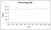
. The highway was built and the US Army gone within a year but by 1951 the population that remained numbered 459 residents. The village was connected to drinking water and sewage system in 1950, and a natural gas in 1954. In large part because of the Women's Institute a library opened in 1951 and a new hospital in 1954. In the following decades the village would remain in the shadow of Dawson Creek as the provincial and federal government offices moved there in the 1970s. The population level fluctuated between 800 and 930 people since then with the peak occurring in 1996 at 928 people. In 2007, a large boundary extension northward over agricultural land neary doubled the area of the village and brought its borders within metres of the City of Dawson Creek's.
Demographics
| Canada 2001 Census Canada 2001 Census The Canada 2001 Census was a detailed enumeration of the Canadian population. Census day was May 15, 2001. On that day, Statistics Canada attempted to count every person in Canada. The total population count of Canada was 30,007,094. This was a 4% increase over 1996 Census of 28,846,761. In... |
||
| Pouce Coupe | British Columbia | |
| Median age | 39.6 years | 38.4 years |
| Under 15 years old | 20% | 18% |
| Between 25 and 44 years old | 26% | 30% |
| Over 65 years old | 23% | 14% |
| Visible minority | 2.8% | 21% |
| Protestant | 31% | 31% |
| No religious affiliation | 41% | 37% |
According to the 2001 Canadian census
Canada 2001 Census
The Canada 2001 Census was a detailed enumeration of the Canadian population. Census day was May 15, 2001. On that day, Statistics Canada attempted to count every person in Canada. The total population count of Canada was 30,007,094. This was a 4% increase over 1996 Census of 28,846,761. In...
, Pouce Coupe had 833 residents living in 275 household
Household
The household is "the basic residential unit in which economic production, consumption, inheritance, child rearing, and shelter are organized and carried out"; [the household] "may or may not be synonymous with family"....
s. Among these, 31% were married couples with children, 20% were married couples without children, and 29% were one-person households. Of 190 reported families
Family
In human context, a family is a group of people affiliated by consanguinity, affinity, or co-residence. In most societies it is the principal institution for the socialization of children...
, 63% were married
Marriage
Marriage is a social union or legal contract between people that creates kinship. It is an institution in which interpersonal relationships, usually intimate and sexual, are acknowledged in a variety of ways, depending on the culture or subculture in which it is found...
couples (average 3.2 persons per family) and 21% were lone parents (3.0 persons per family). Residents of the village were slightly older than the provincial average, but with a federally-subsidized 60 bed care home located in the village a much greater proportion of residents were seniors. Widows comprised 16% of residents over 20 years old, higher than the provincial average of 6%. With 10% of Pouce Coupe residents being foreign-born, and 94% with an English-only mother tongue, the village has few visible minorities. While not counted as visible minorities during the census, 145 people considered themselves to have an Aboriginal identity, five times the provincial 4% average. The census found that over 85% of the housing stock was owned, while only 15% was rented, while provincially 67% was owned and 33% rented.
Infrastructure

Alberta
Alberta is a province of Canada. It had an estimated population of 3.7 million in 2010 making it the most populous of Canada's three prairie provinces...
(x km (xx mi) southeast). Pouce Coupe's internal street network has 14 km (8.7 mi) of paved and 5 km (3.1 mi) of unpaved road. The village's commercial activities are centered around the bend in highway. The residential areas are located mostly south of the highway with a gridiron layout. Industry is located north of the highway and agriculture to the west.
Pouce Coupe does not have rail, air, and bus services within its borders but uses those services as they are available in Dawson Creek. The rail lines actually goes through Pouce Coupe, through the north beside by the highway and southwestern corner, but does not stop. The next place the train stops, after leaving Dawson Creek and going south through Pouce Coupe, is in Hythe, Alberta
Hythe, Alberta
Hythe is a village in northern Alberta, Canada. It is located approximately 54 km west of Grande Prairie, the nearest major urban centre, on Highway 43. It is located in the centre of the Peace River Country, and supports a rural agricultural economy. It has an elementary school and a junior high...
. Pouce Coupe is serviced by the Dawson Creek Airport
Dawson Creek Airport
Dawson Creek Airport, , is located southeast of Dawson Creek, British Columbia, Canada.Ian Darling is the Airport Manager.-Airlines and destinations:-External links:* on COPA's Places to Fly airport directory...
which is located in the southeastern corner of the Dawson Creek municipal borders. The airport was built in 1963 and had its 1,524 m (5,000 ft) runway paved in 1966. Regional bus service, as offered by Greyhound Bus Lines, is accessed through Dawson Creek.
The Village's drinking water
Water supply
Water supply is the provision of water by public utilities, commercial organisations, community endeavours or by individuals, usually via a system of pumps and pipes...
is supplied by the City of Dawson Creek. The water is drawn from the Kiskatinaw River 16 km west of the city and pumped through a booster pump station, a settling pond, a storage pond and a water treatment plant where it is chlorinated. The Village's sewage
Sewage treatment
Sewage treatment, or domestic wastewater treatment, is the process of removing contaminants from wastewater and household sewage, both runoff and domestic. It includes physical, chemical, and biological processes to remove physical, chemical and biological contaminants...
is collected by 7 kilometres (4.3 mi) of sanitary sewer
Sanitary sewer
A sanitary sewer is a separate underground carriage system specifically for transporting sewage from houses and commercial buildings to treatment or disposal. Sanitary sewers serving industrial areas also carry industrial wastewater...
s and processed through a two-cell lagoon
Aerated lagoon
An aerated lagoon or aerated basin is a holding and/or treatment pond provided with artificial aeration to promote the biological oxidation of wastewaters. There are many other biological processes for treatment of wastewaters, for example activated sludge, trickling filters, rotating biological...
system. Electricity is provided by BC Hydro
BC Hydro
The BC Hydro and Power Authority is a Canadian electric utility in the province of British Columbia generally known simply as BC Hydro. It is the main electric distributor, serving 1.8 million customers in most areas, with the exception of the Kootenay region, where FortisBC, a subsidiary of Fortis...
and natural gas by Pacific Northern Gas.
Geography and climate
| Weather | ||
| Time | Temperature | Precipitation |
| January | −14 °C (6 °F) | 3.0 cm (1.2 in) |
| July | 14 °C (57 °F) | 5.6 cm (2.2 in) |
| Average annual precipitation : 45.5 cm (17.9 in) | ||
| Source: Weatherbase | ||
Pouce Coupe is located in the western portion of the Peace River Country
Peace River Country
The Peace River Country is an aspen parkland region around the Peace River in Canada. It spans from northwestern Alberta to the Rocky Mountains in northeastern British Columbia, where the region is also referred to as the Peace River Block.- Geography :The Peace River Country includes the...
amidst the Pouce Coupe Prairie. It is in the B.C. Peace Lowland ecosection of the Canadian Boreal Plains ecozone
Ecozone
An ecozone is the broadest biogeographic division of the Earth's land surface, based on distributional patterns of terrestrial organisms.Ecozones delineate large areas of the Earth's surface within which organisms have been evolving in relative isolation over long periods of time, separated from...
. The village slopes southeastwards towards the confluence of Bissette Creek, which flows along its southern border, and Pouce Coupe River
Pouce Coupe River
Pouce Coupe is a river in Alberta and British Columbia, Canada. It is a major tributary of the Peace River.Originating in Alberta's Saddle Hills County, it flows into British Columbia's Peace River Regional District, then returns in Alberta in Clear Hills County, where it empties into the Peace...
which flows northward along its eastern border. Deer, elk, moose are common. The general area, located in the Cordillera Climatic Region, has a subhumid low boreal ecoclimate and experiences a cool continental climate
Continental climate
Continental climate is a climate characterized by important annual variation in temperature due to the lack of significant bodies of water nearby...
, with an average annual temperature of 1.4 °C (34.5 °F) and snowfall of 170.7 cm (67.2 in). The summers are warm and dry resulting from Pacific air masses that lose much of their moisture going through a number of mountain ranges. The winters are frigid from exposure to the Arctic air masses, however, the village experiences heavy winds year round. Because it experiences long daylight hours in summer and short daylight hours in winter, the village uses Mountain Standard Time year-round.
Economy and education
| Economy | ||
| Rate | Village | Province |
| Unemployment rate | 15.0% | 8.5% |
| Participation rate | 56.6% | 65.2% |
| Poverty rate | 20.8% | 17.8% |
| Average male income | $50,721 | $50,191 |
| Average female income | $24,181 | $35,895 |
| Source: Canada 2001 Census Canada 2001 Census The Canada 2001 Census was a detailed enumeration of the Canadian population. Census day was May 15, 2001. On that day, Statistics Canada attempted to count every person in Canada. The total population count of Canada was 30,007,094. This was a 4% increase over 1996 Census of 28,846,761. In... |
||
The 2001 Canadian census recorded 315 income-earners over the age of 15 residing in Pouce Coupe; of these, 110 worked full-time throughout the year. The village has both higher unemployment
Unemployment
Unemployment , as defined by the International Labour Organization, occurs when people are without jobs and they have actively sought work within the past four weeks...
and poverty rates and lower participation rate
Labor force
In economics, a labor force or labour force is a region's combined civilian workforce, including both the employed and unemployed.Normally, the labor force of a country consists of everyone of working age In economics, a labor force or labour force is a region's combined civilian workforce,...
than the provincial averages. The low participation rate reflects the relatively old population which consists of retired rural farmers and residents. Being a retirement destination, the two largest employers in Pouce Coupe in 2005 were two healthcare homes. Industrial business is concentrated in the highway and oil & gas field construction and servicing. Being only about 10 km from Dawson Creek's downtown and industrial park, residents commute to the larger city for employment, shopping and services. The 2001 Census estimated that only 3% of people in Pouce Coupe between 20 and 64 years old graduated from a university, a fraction of the 24% provincial average and 40% did not graduate from secondary school, double the provincial average.
The only school in the village is the Pouce Coupe Elementary School. It has the capacity for 450 students but the enrollment has decreased from 148 to 99 students between 2001 and 2006. A study by the Fraser Institute
Fraser Institute
The Fraser Institute is a Canadian think tank. It has been described as politically conservative and right-wing libertarian and espouses free market principles...
found that the elementary school had one of the worst academic performances in the province in 2004. The village elects one school board
Board of education
A board of education or a school board or school committee is the title of the board of directors or board of trustees of a school, local school district or higher administrative level....
trustee, for representation on School District 59
School District 59 Peace River South
School District 59 Peace River South is a school district in northeastern British Columbia near the Alberta border. Centered in Dawson Creek, it includes the communities of Chetwynd, Tumbler Ridge, and Pouce Coupe.-Schools:...
. Pouce Coupe students commute to South Peace Secondary School
South Peace Secondary School
South Peace Secondary is a public high school in Dawson Creek, British Columbia part of School District 59 Peace River South. The building is two floors without counting the basement, but a large majority of the classes are held on the ground floor. Generally shaped like a square with two "wings"....
in Dawson Creek for high school education. Northern Lights College
Northern Lights College
Northern Lights College is an institution that provides post-secondary education to residents of Northern British Columbia. It currently has offices in eight communities, and a working agreement with the University of Northern British Columbia. The college president is D. Jean Valgardson.- List of...
, also in Dawson Creek, is the closest post-secondary school.
Culture, recreation and media
Other than an annual Canada Day parade and festival, there are few cultural or recreational events within the village. No newspapers or television/radio stations operate within the village but the Peace River Block Daily News and CJDC-TVCJDC-TV
CJDC-TV is a television station in Dawson Creek, British Columbia. It is owned by Astral Media and is the CBC Television affiliate in that city...
include Pouce Coupe in their coverage. The municipality operates the Pouce Coupe Municipal Library and two parks: Village Square and Harden Park. The South Peace Community Multiplex, located between the city and the village and partly funded by the village, will have, once opened in 2007, an aquatic centre with an olympic-sized swimming pool, an indoor equestrian centre, and an indoor running track. The Peace River Regional District manages the Pouce Coupe Regional Park, on the southern border of the municipality, which has an amphitheatre and camping spots. Nearby provincial parks include the Sudeten Provincial Park
Sudeten Provincial Park
Sudeten Provincial Park is a provincial park in British Columbia, Canada....
, Swan Lake Provincial Park
Swan Lake Provincial Park
-External links:...
, and One Island Lake Provincial Park
One Island Lake Provincial Park
One Island Lake Provincial Park is a provincial park in British Columbia, Canada.-Conservation:Established between the Kiskatinaw River and the West Kiskatinaw River, the park provides representation of the Kiskatinaw Plateau ecosection. Moose, white-tail and mule deer, beaver and black bear are...
all to the south. Bear Mountain, to the west, has a downhill ski complex and an extensive trail system used for motorized and non-motorized recreation. With Dawson Creek so close, many Pouce Coupe residents use cultural and recreational facilities there.
Pouce Coupe Museum
The Pouce Coupe Museum which is housed in the Northern Alberta Railway Station (c. 1931). A volunteer historical society runs the Pouce Coupe & District Museum. The Museum is affiliated with: CMACanadian Museums Association
The Canadian Museums Association is a national organization for the promotion of museums in Canada.The Canadian Museums Association is the national organization for the advancement of the Canadian museum sector, representing Canadian museum professionals both within Canada and internationally. The...
, CHIN
Canadian Heritage Information Network
The Canadian Heritage Information Network is a Canadian government-supported organization that provides a networked interface to Canada's heritage, largely through the World Wide Web. It aims to give access to Canada's heritage for both Canadians and a worldwide audience, by supporting the...
, and Virtual Museum of Canada
Virtual Museum of Canada
The Virtual Museum of Canada is Canada's national virtual museum. With a directory of over 3,000 Canadian heritage institutions and a database of over 600 virtual exhibits, the VMC brings together Canada's museums regardless of size or geographical location.The VMC includes virtual exhibits,...
.
Government and politics
The Village of Pouce Coupe's council-manager form of municipal government is headed by a mayor (who also represents Pouce Coupe on the Peace River Regional District's governing board) and a four-member council; these positions are subject to at-largePlurality-at-large voting
Plurality-at-large voting is a non-proportional voting system for electing several representatives from a single multimember electoral district using a series of check boxes and tallying votes similar to a plurality election...
elections every three years. Current mayor, Larry Fynn was elected in November 2011, defeating incumbent mayor Lyman Clark, who in turn defeated incumbent mayor Barb Smith in 2008. Smith had defeated Sandy Hull, who was acting-mayor since the death of mayor Doyle McNabb in April 2005. The village funds and administers a sewerage system, a volunteer fire department, a library, parks, a cemetery, street lights, and roads except the highway.
Pouce Coupe is part of the Peace River South
Peace River South
Peace River South is a provincial electoral district for the Legislative Assembly of British Columbia, Canada. It was created under the name South Peace River by the Constitution Amendment Act, 1955, which split the old riding of Peace River into northern and southern portions for the 1956 B.C....
provincial electoral district, represented by Blair Lekstrom
Blair Lekstrom
Blair Lekstrom is a Canadian politician, currently a member of the Legislative Assembly of British Columbia. He has represented the riding of Peace River South since the 2001 election....
in the Legislative Assembly of British Columbia
Legislative Assembly of British Columbia
The Legislative Assembly of British Columbia is one of two components of the Parliament of British Columbia, the provincial parliament ....
. In the 2001 provincial election
British Columbia general election, 2001
The British Columbia general election of 2001 was the 37th provincial election in the Province of British Columbia, Canada. It was held to elect members of the Legislative Assembly of British Columbia. The election was called on April 18, 2001, and held on May 16, 2001...
, he was elected as the district's Member of the Legislative Assembly
Member of the Legislative Assembly
A Member of the Legislative Assembly or a Member of the Legislature , is a representative elected by the voters of a constituency to the legislature or legislative assembly of a sub-national jurisdiction....
with 57% support from the city's polls and re-elected in 2005
British Columbia general election, 2005
The 38th British Columbia general election was held on May 17, 2005, to elect members of the Legislative Assembly of the Province of British Columbia , Canada. The BC Liberal Party formed the government of the province prior to this general election under the leadership of Premier Gordon Campbell...
with 50% support. Before Lekstrom, Peace River South was represented by Jack Weisgerber
Jack Weisgerber
John Sylvester Weisgerber is a Canadian politician and businessman. He is a former member of the Legislative Assembly in British Columbia. During his political career he was briefly the leader of both the British Columbia Social Credit Party and the Reform Party of British Columbia...
. Weisgerber represented the riding
Electoral district (Canada)
An electoral district in Canada, also known as a constituency or a riding, is a geographical constituency upon which Canada's representative democracy is based...
between 1986
British Columbia general election, 1986
The British Columbia general election of 1986 was the 34th general election in the Province of British Columbia, Canada. It was held to elect members of the Legislative Assembly of British Columbia. The election was called on September 24, 1986...
and 2001 as a member of the Social Credit Party of British Columbia, which made him Minister of Energy, Mines and Petroleum Resources and Minister of Native Affairs before becoming party leader between 1992 and 1993. In 1996
British Columbia general election, 1996
The British Columbia general election of 1996 was the thirty sixth provincial election in the Province of British Columbia, Canada. It was held to elect members of the Legislative Assembly of British Columbia. The election was called on April 30, 1996, and held on May 28, 1996...
as leader of the Reform Party of British Columbia
Reform Party of British Columbia
The Reform Party of British Columbia is a populist right wing political party in British Columbia, Canada. Although its name is similar to the defunct Reform Party of Canada, the provincial party was founded before the federal party was and it did not have any formal association with...
, Weisgerber won re-election even though Pouce Coupe polls put him in third place behind the losing BC Liberal Party
British Columbia Liberal Party
The British Columbia Liberal Party is the governing political party in British Columbia, Canada. First elected for government in 1916, the party went into decline after 1952, with its rump caucus merging with the Social Credit Party for the 1975 election...
and New Democratic Party
New Democratic Party of British Columbia
The New Democratic Party of British Columbia is a social-democratic political party in British Columbia, Canada. The party currently forms the official opposition to the governing British Columbia Liberal Party following the 2009 provincial election in British Columbia.The BC NDP is the provincial...
candidates.
Federally, Pouce Coupe is located in the Prince George—Peace River
Prince George—Peace River
Prince George—Peace River is a federal electoral district in British Columbia, Canada, that has been represented in the Canadian House of Commons since 1968.-Geography:...
riding, represented in the Canadian House of Commons
Canadian House of Commons
The House of Commons of Canada is a component of the Parliament of Canada, along with the Sovereign and the Senate. The House of Commons is a democratically elected body, consisting of 308 members known as Members of Parliament...
by Conservative Party
Conservative Party of Canada
The Conservative Party of Canada , is a political party in Canada which was formed by the merger of the Canadian Alliance and the Progressive Conservative Party of Canada in 2003. It is positioned on the right of the Canadian political spectrum...
Member of Parliament
Member of Parliament
A Member of Parliament is a representative of the voters to a :parliament. In many countries with bicameral parliaments, the term applies specifically to members of the lower house, as upper houses often have a different title, such as senate, and thus also have different titles for its members,...
Bob Zimmer. Prior to Zimmer, the village was represented by Conservative Party member Jay Hill
Jay Hill
Jay D. Hill PC is a former Canadian politician and member of the Conservative Party of Canada. He was the Member of Parliament for the riding of Prince George—Peace River from 1993 until his retirement in 2010. He also served as Government House Leader in the Canadian House of Commons during his...
, who was first elected in 1993
Canadian federal election, 1993
The Canadian federal election of 1993 was held on October 25 of that year to elect members to the Canadian House of Commons of the 35th Parliament of Canada. Fourteen parties competed for the 295 seats in the House at that time...
. Prior to Hill, the riding was represented by former Chetwynd mayor Frank Oberle
Frank Oberle, Sr.
Frank Oberle, Sr., PC is a businessman and former Canadian politician.Born in Forchheim near Karlsruhe, Germany, Oberle moved with his family to German-occupied Poland in 1941. There he was placed in a Hitler Youth indoctrination program...
of the Progressive Conservative Party
Progressive Conservative Party of Canada
The Progressive Conservative Party of Canada was a Canadian political party with a centre-right stance on economic issues and, after the 1970s, a centrist stance on social issues....
who served as Minister of Science and Technology and later as Minister of Forestry.