
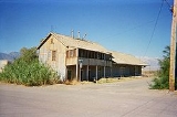
Keeler, California
Encyclopedia
Keeler is a census-designated place
(CDP) in Inyo County
, California
, United States
. Keeler is located on the east shore of Owens Lake
11.5 miles (19 km) south-southeast of New York Butte, at an elevation of 3602 feet (1098 m). The population was 66 at the 2010 census, unchanged from the 2000 census.
, the CDP has a total area of 1.3 square miles (3.4 km²), all land.
Keeler is located along the eastern shores of Owens Lake
(a dry lakebed) along State Route 136.
rendered the pier in nearby Swansea
inaccessible by uplifting the shoreline, a new pier was constructed to the south at a community named Hawley. In 1880 a new mill was constructed at Hawley by the Owens Lake Mining and Milling Company for processing ore from the Cerro Gordo Mines
in the mountains to the east. A town was laid out by the company agent Julius M. Keeler, for whom the town of Hawley was later renamed.
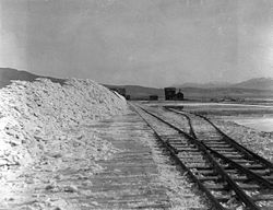
The steamship "Bessie Brady" brought ore from Keeler across the lake to the town of Cartago, however in 1882 the Bessie Brady was destroyed by fire. There was a 300-foot wharf at Keeler, and the steamship route cut days off the time for a freight wagon to circle the lake. She carried 700 ingots at a time in a three-hour crossing. The Carson and Colorado Railroad
constructed a narrow gauge railway to Keeler in 1883. The success of the Cerro Gordo mines caused Keeler to boom until silver prices plummeted in the late 1800s.
A second boom of zinc mining in the early 1900s brought new life to the town and a tramway was built to bring the ore from Cerro Gordo to Keeler. There were small surges in the mining of silver, lead, zinc, and limestone; however, by the 1950s all mining had ceased. Train service was stopped in 1960 and the tracks were removed in 1961. Water exports from the Owens Valley to the City of Los Angeles
in the 1920s led the Owens Lake to eventually dry up, causing alkali dust storms to blow through Keeler, driving many residents away. Dust remediation efforts in the early 21st century reduced this problem, but few residents remain.
A post office operated at Keeler from 1883 to 1898 and is still operating today.
was 50.7 people per square mile (19.6/km²). The racial makeup of Keeler was 63 (95.5%) White, 0 (0.0%) African American, 0 (0.0%) Native American, 2 (3.0%) Asian, 0 (0.0%) Pacific Islander, 0 (0.0%) from other races
, and 1 (1.5%) from two or more races. Hispanic or Latino of any race were 6 persons (9.1%).
The Census reported that 66 people (100% of the population) lived in households, 0 (0%) lived in non-institutionalized group quarters, and 0 (0%) were institutionalized.
There were 40 households, out of which 4 (10.0%) had children under the age of 18 living in them, 13 (32.5%) were opposite-sex married couples
living together, 2 (5.0%) had a female householder with no husband present, 2 (5.0%) had a male householder with no wife present. There were 0 (0%) unmarried opposite-sex partnerships
, and 0 (0%) same-sex married couples or partnerships. 23 households (57.5%) were made up of individuals and 12 (30.0%) had someone living alone who was 65 years of age or older. The average household size was 1.65. There were 17 families
(42.5% of all households); the average family size was 2.53.
The population was spread out with 9 people (13.6%) under the age of 18, 1 people (1.5%) aged 18 to 24, 1 people (1.5%) aged 25 to 44, 33 people (50.0%) aged 45 to 64, and 22 people (33.3%) who were 65 years of age or older. The median age was 59.3 years. For every 100 females there were 120.0 males. For every 100 females age 18 and over, there were 147.8 males.
There were 67 housing units at an average density of 51.5 per square mile (19.9/km²), of which 33 (82.5%) were owner-occupied, and 7 (17.5%) were occupied by renters. The homeowner vacancy rate was 2.9%; the rental vacancy rate was 22.2%. 55 people (83.3% of the population) lived in owner-occupied housing units and 11 people (16.7%) lived in rental housing units.
of 2000, there were 66 people, 36 households, and 19 families residing in the CDP. The population density
was 54.9 people per square mile (21.2/km²). There were 67 housing units at an average density of 55.7 per square mile (21.6/km²). The racial makeup of the CDP was 96.97% White
, 1.52% from other races
, and 1.52% from two or more races. 12.12% of the population were Hispanic
or Latino
of any race.
There were 36 households out of which 11.1% had children under the age of 18 living with them, 38.9% were married couples
living together, 5.6% had a female householder with no husband present, and 47.2% were non-families. 38.9% of all households were made up of individuals and 22.2% had someone living alone who was 65 years of age or older. The average household size was 1.83 and the average family size was 2.37.
In the CDP the population was spread out with 13.6% under the age of 18, 1.5% from 18 to 24, 10.6% from 25 to 44, 36.4% from 45 to 64, and 37.9% who were 65 years of age or older. The median age was 57 years. For every 100 females there were 112.9 males. For every 100 females age 18 and over, there were 111.1 males.
The median income for a household in the CDP was $19,625, and the median income for a family was $26,250. The per capita income
for the CDP was $18,621. There were no families and 8.5% of the population living below the poverty line, including no under eighteens and none of those over 64.
Keeler is located in the 18th Senate
District, represented by Republican
Roy Ashburn
, and in the 18th Assembly
District, represented by Republican Bill Maze
. Federally, Keeler is located in California's 25th congressional district
, which has a Cook PVI
of R +7 and is represented by Republican Buck McKeon
.
' novel, McTeague
(1899
).
Census-designated place
A census-designated place is a concentration of population identified by the United States Census Bureau for statistical purposes. CDPs are delineated for each decennial census as the statistical counterparts of incorporated places such as cities, towns and villages...
(CDP) in Inyo County
Inyo County, California
-National protected areas:* Death Valley National Park * Inyo National Forest * Manzanar National Historic Site-Major highways:* U.S. Route 6* U.S. Route 395* State Route 127* State Route 136* State Route 168* State Route 178...
, California
California
California is a state located on the West Coast of the United States. It is by far the most populous U.S. state, and the third-largest by land area...
, United States
United States
The United States of America is a federal constitutional republic comprising fifty states and a federal district...
. Keeler is located on the east shore of Owens Lake
Owens Lake
Owens Lake is a mostly dry lake in the Owens Valley on the eastern side of the Sierra Nevada in Inyo County, California. It is located about south of Lone Pine, California...
11.5 miles (19 km) south-southeast of New York Butte, at an elevation of 3602 feet (1098 m). The population was 66 at the 2010 census, unchanged from the 2000 census.
Geography
According to the United States Census BureauUnited States Census Bureau
The United States Census Bureau is the government agency that is responsible for the United States Census. It also gathers other national demographic and economic data...
, the CDP has a total area of 1.3 square miles (3.4 km²), all land.
Keeler is located along the eastern shores of Owens Lake
Owens Lake
Owens Lake is a mostly dry lake in the Owens Valley on the eastern side of the Sierra Nevada in Inyo County, California. It is located about south of Lone Pine, California...
(a dry lakebed) along State Route 136.
History
When the 1872 Lone Pine earthquake1872 Lone Pine earthquake
The Great Lone Pine earthquake was one of the largest earthquakes to hit California in recorded history. The quake struck on March 26, 1872 and its epicenter was near Lone Pine, California in Owens Valley...
rendered the pier in nearby Swansea
Swansea, California
Swansea is an unincorporated community in Inyo County, California. It is located south of New York Butte, at an elevation of 3661 feet .Swansea was a boomtown located on the eastern shore of Owens Lake...
inaccessible by uplifting the shoreline, a new pier was constructed to the south at a community named Hawley. In 1880 a new mill was constructed at Hawley by the Owens Lake Mining and Milling Company for processing ore from the Cerro Gordo Mines
Cerro Gordo Mines
The Cerro Gordo Mines were a collection of mines located in the Inyo Mountains, in Inyo County, California. Mining operations were undertaken from 1866 until 1957, producing high grade silver, lead, and zinc ore. Some ore was smelted on site, however the remote location led to larger scale...
in the mountains to the east. A town was laid out by the company agent Julius M. Keeler, for whom the town of Hawley was later renamed.
The steamship "Bessie Brady" brought ore from Keeler across the lake to the town of Cartago, however in 1882 the Bessie Brady was destroyed by fire. There was a 300-foot wharf at Keeler, and the steamship route cut days off the time for a freight wagon to circle the lake. She carried 700 ingots at a time in a three-hour crossing. The Carson and Colorado Railroad
Carson and Colorado Railroad
The Carson and Colorado Railway was a U.S. narrow gauge railroad that ran from Mound House, Nevada, to Keeler, California below the Cerro Gordo Mines. It was incorporated on May 10, 1880 as the Carson and Colorado Railroad, and construction on the railroad began on May 31, 1880. A track gauge of ...
constructed a narrow gauge railway to Keeler in 1883. The success of the Cerro Gordo mines caused Keeler to boom until silver prices plummeted in the late 1800s.
A second boom of zinc mining in the early 1900s brought new life to the town and a tramway was built to bring the ore from Cerro Gordo to Keeler. There were small surges in the mining of silver, lead, zinc, and limestone; however, by the 1950s all mining had ceased. Train service was stopped in 1960 and the tracks were removed in 1961. Water exports from the Owens Valley to the City of Los Angeles
Los Ángeles
Los Ángeles is the capital of the province of Biobío, in the commune of the same name, in Region VIII , in the center-south of Chile. It is located between the Laja and Biobío rivers. The population is 123,445 inhabitants...
in the 1920s led the Owens Lake to eventually dry up, causing alkali dust storms to blow through Keeler, driving many residents away. Dust remediation efforts in the early 21st century reduced this problem, but few residents remain.
A post office operated at Keeler from 1883 to 1898 and is still operating today.
Demographics
2010
The 2010 United States Census reported that Keeler had a population of 66. The population densityPopulation density
Population density is a measurement of population per unit area or unit volume. It is frequently applied to living organisms, and particularly to humans...
was 50.7 people per square mile (19.6/km²). The racial makeup of Keeler was 63 (95.5%) White, 0 (0.0%) African American, 0 (0.0%) Native American, 2 (3.0%) Asian, 0 (0.0%) Pacific Islander, 0 (0.0%) from other races
Race (United States Census)
Race and ethnicity in the United States Census, as defined by the Federal Office of Management and Budget and the United States Census Bureau, are self-identification data items in which residents choose the race or races with which they most closely identify, and indicate whether or not they are...
, and 1 (1.5%) from two or more races. Hispanic or Latino of any race were 6 persons (9.1%).
The Census reported that 66 people (100% of the population) lived in households, 0 (0%) lived in non-institutionalized group quarters, and 0 (0%) were institutionalized.
There were 40 households, out of which 4 (10.0%) had children under the age of 18 living in them, 13 (32.5%) were opposite-sex married couples
Marriage
Marriage is a social union or legal contract between people that creates kinship. It is an institution in which interpersonal relationships, usually intimate and sexual, are acknowledged in a variety of ways, depending on the culture or subculture in which it is found...
living together, 2 (5.0%) had a female householder with no husband present, 2 (5.0%) had a male householder with no wife present. There were 0 (0%) unmarried opposite-sex partnerships
POSSLQ
POSSLQ is an abbreviation for "Persons of Opposite Sex Sharing Living Quarters," a term coined in the late 1970s by the United States Census Bureau as part of an effort to more accurately gauge the prevalence of cohabitation in American households....
, and 0 (0%) same-sex married couples or partnerships. 23 households (57.5%) were made up of individuals and 12 (30.0%) had someone living alone who was 65 years of age or older. The average household size was 1.65. There were 17 families
Family (U.S. Census)
A family or family household is defined by the United States Census Bureau for statistical purposes as "a householder and one or more other people related to the householder by birth, marriage, or adoption. They do not include same-sex married couples even if the marriage was performed in a state...
(42.5% of all households); the average family size was 2.53.
The population was spread out with 9 people (13.6%) under the age of 18, 1 people (1.5%) aged 18 to 24, 1 people (1.5%) aged 25 to 44, 33 people (50.0%) aged 45 to 64, and 22 people (33.3%) who were 65 years of age or older. The median age was 59.3 years. For every 100 females there were 120.0 males. For every 100 females age 18 and over, there were 147.8 males.
There were 67 housing units at an average density of 51.5 per square mile (19.9/km²), of which 33 (82.5%) were owner-occupied, and 7 (17.5%) were occupied by renters. The homeowner vacancy rate was 2.9%; the rental vacancy rate was 22.2%. 55 people (83.3% of the population) lived in owner-occupied housing units and 11 people (16.7%) lived in rental housing units.
2000
As of the censusCensus
A census is the procedure of systematically acquiring and recording information about the members of a given population. It is a regularly occurring and official count of a particular population. The term is used mostly in connection with national population and housing censuses; other common...
of 2000, there were 66 people, 36 households, and 19 families residing in the CDP. The population density
Population density
Population density is a measurement of population per unit area or unit volume. It is frequently applied to living organisms, and particularly to humans...
was 54.9 people per square mile (21.2/km²). There were 67 housing units at an average density of 55.7 per square mile (21.6/km²). The racial makeup of the CDP was 96.97% White
Race (United States Census)
Race and ethnicity in the United States Census, as defined by the Federal Office of Management and Budget and the United States Census Bureau, are self-identification data items in which residents choose the race or races with which they most closely identify, and indicate whether or not they are...
, 1.52% from other races
Race (United States Census)
Race and ethnicity in the United States Census, as defined by the Federal Office of Management and Budget and the United States Census Bureau, are self-identification data items in which residents choose the race or races with which they most closely identify, and indicate whether or not they are...
, and 1.52% from two or more races. 12.12% of the population were Hispanic
Race (United States Census)
Race and ethnicity in the United States Census, as defined by the Federal Office of Management and Budget and the United States Census Bureau, are self-identification data items in which residents choose the race or races with which they most closely identify, and indicate whether or not they are...
or Latino
Race (United States Census)
Race and ethnicity in the United States Census, as defined by the Federal Office of Management and Budget and the United States Census Bureau, are self-identification data items in which residents choose the race or races with which they most closely identify, and indicate whether or not they are...
of any race.
There were 36 households out of which 11.1% had children under the age of 18 living with them, 38.9% were married couples
Marriage
Marriage is a social union or legal contract between people that creates kinship. It is an institution in which interpersonal relationships, usually intimate and sexual, are acknowledged in a variety of ways, depending on the culture or subculture in which it is found...
living together, 5.6% had a female householder with no husband present, and 47.2% were non-families. 38.9% of all households were made up of individuals and 22.2% had someone living alone who was 65 years of age or older. The average household size was 1.83 and the average family size was 2.37.
In the CDP the population was spread out with 13.6% under the age of 18, 1.5% from 18 to 24, 10.6% from 25 to 44, 36.4% from 45 to 64, and 37.9% who were 65 years of age or older. The median age was 57 years. For every 100 females there were 112.9 males. For every 100 females age 18 and over, there were 111.1 males.
The median income for a household in the CDP was $19,625, and the median income for a family was $26,250. The per capita income
Per capita income
Per capita income or income per person is a measure of mean income within an economic aggregate, such as a country or city. It is calculated by taking a measure of all sources of income in the aggregate and dividing it by the total population...
for the CDP was $18,621. There were no families and 8.5% of the population living below the poverty line, including no under eighteens and none of those over 64.
Politics
In the state legislatureCalifornia State Legislature
The California State Legislature is the state legislature of the U.S. state of California. It is a bicameral body consisting of the lower house, the California State Assembly, with 80 members, and the upper house, the California State Senate, with 40 members...
Keeler is located in the 18th Senate
California State Senate
The California State Senate is the upper house of the California State Legislature. There are 40 state senators. The state legislature meets in the California State Capitol in Sacramento. The Lieutenant Governor is the ex officio President of the Senate and may break a tied vote...
District, represented by Republican
Republican Party (United States)
The Republican Party is one of the two major contemporary political parties in the United States, along with the Democratic Party. Founded by anti-slavery expansion activists in 1854, it is often called the GOP . The party's platform generally reflects American conservatism in the U.S...
Roy Ashburn
Roy Ashburn
Roy Arthur Ashburn is an American politician from Kern County, California. A Republican, he served as a California State Senator from 2002 to 2010 representing the 18th district. He previously served three terms in the California State Assembly, representing the 32nd district and 12 years on the...
, and in the 18th Assembly
California State Assembly
The California State Assembly is the lower house of the California State Legislature. There are 80 members in the Assembly, representing an approximately equal number of constituents, with each district having a population of at least 420,000...
District, represented by Republican Bill Maze
Bill Maze
Bill Maze is an American politician from California and a member of the Republican Party. Maze is the president of Citizens for Saving California Farming Industries, a non-profit dedicated to dividing California into two states....
. Federally, Keeler is located in California's 25th congressional district
California's 25th congressional district
California's 25th congressional district is a congressional district in the U.S. state of California that covers part of Los Angeles County and extends out to broad stretches of interior California along the Nevada border. It includes the cities of Santa Clarita, Palmdale, Lancaster, and the...
, which has a Cook PVI
Cook Partisan Voting Index
The Cook Partisan Voting Index , sometimes referred to as simply the Partisan Voting Index , is a measurement of how strongly an American congressional district or state leans toward one political party compared to the nation as a whole...
of R +7 and is represented by Republican Buck McKeon
Howard McKeon
Howard Philip "Buck" McKeon is the U.S. Representative for , serving since 1993. He is a member of the Republican Party.-Early life, education and career:...
.
Reference in fiction
Keeler is mentioned in the final chapters of Frank NorrisFrank Norris
Benjamin Franklin Norris, Jr. was an American novelist, during the Progressive Era, writing predominantly in the naturalist genre. His notable works include McTeague , The Octopus: A Story of California , and The Pit .-Life:Frank Norris was born in Chicago, Illinois in 1870...
' novel, McTeague
McTeague
McTeague is a novel by Frank Norris, first published in 1899. It tells the story of a couple's courtship and marriage, and their subsequent descent into poverty, violence and finally murder as the result of jealousy and avarice...
(1899
1899 in literature
The year 1899 in literature involved some significant new books.-Events:*Edgar Rice Burroughs begins working in his father's business.*Rainer Maria Rilke travels to Moscow to meet Leo Tolstoy....
).