

1872 Lone Pine earthquake
Encyclopedia
Earthquake
An earthquake is the result of a sudden release of energy in the Earth's crust that creates seismic waves. The seismicity, seismism or seismic activity of an area refers to the frequency, type and size of earthquakes experienced over a period of time...
s to hit California
California
California is a state located on the West Coast of the United States. It is by far the most populous U.S. state, and the third-largest by land area...
in recorded history. The quake struck on March 26, 1872 and its epicenter
Epicenter
The epicenter or epicentre is the point on the Earth's surface that is directly above the hypocenter or focus, the point where an earthquake or underground explosion originates...
was near Lone Pine, California
Lone Pine, California
Lone Pine is a census-designated place in Inyo County, California, United States. Lone Pine is located south-southeast of Independence, at an elevation of 3727 feet . The population was 2,035 at the 2010 census, up from 1,655 at the 2000 census. The town is located in the Owens Valley, near the...
in Owens Valley
Owens Valley
Owens Valley is the arid valley of the Owens River in eastern California in the United States, to the east of the Sierra Nevada and west of the White Mountains and Inyo Mountains on the west edge of the Great Basin section...
. The true size of this earthquake is not known, but historical evidence detailing the damage it caused in settlements and landforms near the epicenter, and the geographic extent to which noticeable movement was felt, leads researchers to estimate a Richter magnitude of 7.6 to 8 or greater — similar in size to the 1906 San Francisco earthquake
1906 San Francisco earthquake
The San Francisco earthquake of 1906 was a major earthquake that struck San Francisco, California, and the coast of Northern California at 5:12 a.m. on Wednesday, April 18, 1906. The most widely accepted estimate for the magnitude of the earthquake is a moment magnitude of 7.9; however, other...
.
The quake hit at 2:35 on a Tuesday morning and leveled almost all the buildings in Lone Pine and nearby settlements. Of the estimated 250-300 inhabitants of Lone Pine, 27 are known to have perished and 52 of the 59 houses were destroyed. One report states that the main buildings were thrown down in almost every town in Inyo County
Inyo County, California
-National protected areas:* Death Valley National Park * Inyo National Forest * Manzanar National Historic Site-Major highways:* U.S. Route 6* U.S. Route 395* State Route 127* State Route 136* State Route 168* State Route 178...
. About 360 kilometres (223.7 mi) south of Lone Pine, at Indian Wells, California
Indian Wells, California
Indian Wells is a city in Riverside County, California, in the Coachella Valley , in between Palm Desert and La Quinta. As of the 2010 census, the city population was 4,958....
, adobe
Adobe
Adobe is a natural building material made from sand, clay, water, and some kind of fibrous or organic material , which the builders shape into bricks using frames and dry in the sun. Adobe buildings are similar to cob and mudbrick buildings. Adobe structures are extremely durable, and account for...
houses sustained cracks. Property loss has been estimated at $250,000 (1872 dollars). As in many earthquakes, adobe
Adobe
Adobe is a natural building material made from sand, clay, water, and some kind of fibrous or organic material , which the builders shape into bricks using frames and dry in the sun. Adobe buildings are similar to cob and mudbrick buildings. Adobe structures are extremely durable, and account for...
, stone and masonry
Masonry
Masonry is the building of structures from individual units laid in and bound together by mortar; the term masonry can also refer to the units themselves. The common materials of masonry construction are brick, stone, marble, granite, travertine, limestone; concrete block, glass block, stucco, and...
structures fared worse than wooden ones which prompted the closing of nearby Camp Independence which was an adobe structure destroyed in the quake.
Sacramento, California
Sacramento is the capital city of the U.S. state of California and the county seat of Sacramento County. It is located at the confluence of the Sacramento River and the American River in the northern portion of California's expansive Central Valley. With a population of 466,488 at the 2010 census,...
, where citizens were startled out of bed and into the streets. Giant rockslide
Rockslide
A rockslide is a type of landslide caused by rock failure in which part of the plane of failure passes through intact rock and where material collapses en masse and not in individual blocks.The mode of failure is different from that of a rock-fall....
s in what is now Yosemite National Park
Yosemite National Park
Yosemite National Park is a United States National Park spanning eastern portions of Tuolumne, Mariposa and Madera counties in east central California, United States. The park covers an area of and reaches across the western slopes of the Sierra Nevada mountain chain...
woke naturalist John Muir
John Muir
John Muir was a Scottish-born American naturalist, author, and early advocate of preservation of wilderness in the United States. His letters, essays, and books telling of his adventures in nature, especially in the Sierra Nevada mountains of California, have been read by millions...
, then living in Yosemite Valley
Yosemite Valley
Yosemite Valley is a glacial valley in Yosemite National Park in the western Sierra Nevada mountains of California, carved out by the Merced River. The valley is about long and up to a mile deep, surrounded by high granite summits such as Half Dome and El Capitan, and densely forested with pines...
, who reportedly ran out of his cabin shouting, "A noble earthquake!" and promptly made a moonlit survey of the fresh talus
Scree
Scree, also called talus, is a term given to an accumulation of broken rock fragments at the base of crags, mountain cliffs, or valley shoulders. Landforms associated with these materials are sometimes called scree slopes or talus piles...
piles. This earthquake stopped clocks and awakened people in San Diego, California
San Diego, California
San Diego is the eighth-largest city in the United States and second-largest city in California. The city is located on the coast of the Pacific Ocean in Southern California, immediately adjacent to the Mexican border. The birthplace of California, San Diego is known for its mild year-round...
, to the south, Red Bluff, California
Red Bluff, California
Red Bluff is a city in and the county seat of Tehama County, California, United States. The population was 14,076 at the 2010 census, up from 13,147 at the 2000 census....
, to the north, and Elko, Nevada
Elko, Nevada
Elko is a city in Elko County, Nevada, United States. The population was 18,297 at the 2010 census. It is the county seat of Elko County. The city straddles the Humboldt River....
, to the east. The shock was felt over most of California and much of Nevada
Nevada
Nevada is a state in the western, mountain west, and southwestern regions of the United States. With an area of and a population of about 2.7 million, it is the 7th-largest and 35th-most populous state. Over two-thirds of Nevada's people live in the Las Vegas metropolitan area, which contains its...
. Thousands of aftershock
Aftershock
An aftershock is a smaller earthquake that occurs after a previous large earthquake, in the same area of the main shock. If an aftershock is larger than the main shock, the aftershock is redesignated as the main shock and the original main shock is redesignated as a foreshock...
s occurred, some severe.
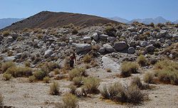
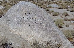
The quake resulted from sudden vertical (15–20 feet/4.5–6 m) and right-lateral (35–40 feet/10.6–12.2 m) movement on the Lone Pine Fault and part of the Owens Valley Fault. These faults
Geologic fault
In geology, a fault is a planar fracture or discontinuity in a volume of rock, across which there has been significant displacement along the fractures as a result of earth movement. Large faults within the Earth's crust result from the action of tectonic forces...
are part of a twin system of normal faults that run along the base of two parallel mountain ranges; the Sierra Nevada on the west and Inyo Mountains
Inyo Mountains
The Inyo Mountains are a short mountain range east of the Sierra Nevada mountains in eastern California in the United States. The range separates the Owens Valley to the west with Saline Valley to the east, extending for approximately 70 mi SSE from the southern end of the White Mountains,...
on the east flank of Owens Valley. This particular event created fault scarp
Fault scarp
A fault scarp is the topographic expression of faulting attributed to the displacement of the land surface by movement along faults. They are exhibited either by differential movement and subsequent erosion along an old inactive geologic fault , or by a movement on a recent active fault...
s from north of Big Pine, California
Big Pine, California
Big Pine is a census-designated place in Inyo County, California, United States. Big Pine is located south-southeast of Bishop, at an elevation of 3990 feet . The population was 1,756 at the 2010 census, up from 1,350 at the 2000 census...
, (55 miles/88 km north of Lone Pine), to Haiwee Reservoir (30 miles/48 km south of Lone Pine).
Researchers later estimated that similar earthquakes occur on the Lone Pine fault every 3,000-4,000 years. However, the Lone Pine fault is only one of many faults on two parallel systems of faults mentioned above.
This earthquake also formed a small graben
Graben
In geology, a graben is a depressed block of land bordered by parallel faults. Graben is German for ditch. Graben is used for both the singular and plural....
that later was filled by water, creating 86 acres (348,030 m²) Diaz Lake
Diaz Lake
Diaz Lake is located in the Owens Valley, just south of Lone Pine, California, United States.-History:The lake was formed by the 1872 Lone Pine earthquake on Tuesday, March 26 of that year when of the Owens Valley dropped approximately 20 feet and a new spring opened, causing water to fill the...
.
Many geoscientists who have studied the area theorize that quakes similar to the 1872 Lone Pine event are responsible for creating Owens Valley (see Basin and Range Province for ideas on what triggers these quakes).
See also
- Earthquakes in CaliforniaEarthquakes in CaliforniaEarthquakes in California are common occurrences as the state is located on the San Andreas Fault, which cuts across California and forms the tectonic boundary between the Pacific and the North American Plate. There are many thousands of small earthquakes per year, most of them are so small that...
- List of earthquakes in the United States
- Category: Geography of Inyo County, California