State Route 73 is a
state highwayState highway, state road or state route can refer to one of three related concepts, two of them related to a state or provincial government in a country that is divided into states or provinces :#A...
in the
U.S. stateA U.S. state is any one of the 50 federated states of the United States of America that share sovereignty with the federal government. Because of this shared sovereignty, an American is a citizen both of the federal entity and of his or her state of domicile. Four states use the official title of...
of
CaliforniaCalifornia is a state located on the West Coast of the United States. It is by far the most populous U.S. state, and the third-largest by land area...
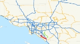
. The route runs from
Interstate 405Interstate 405 is a major north–south Interstate Highway in Southern California. It is a bypass of Interstate 5, running along the western areas of the Greater Los Angeles Area from Irvine in the south to near San Fernando in the north...
to Interstate 5 through the
San Joaquin HillsThe San Joaquin Hills are a set of low hills in coastal Orange County, California. They extend in a northwest-southeast direction, starting in the northwest in Newport Beach at the southern edge of the Los Angeles Basin, and extending southeast to San Juan Capistrano.-Geography and habitats:Named...
in
Orange CountyOrange County is a county in the U.S. state of California. Its county seat is Santa Ana. As of the 2010 census, its population was 3,010,232, up from 2,846,293 at the 2000 census, making it the third most populous county in California, behind Los Angeles County and San Diego County...
. From its northern terminus, the first three miles (5 km) of the highway are called the
Corona del Mar Freeway; this section of highway opened in 1978. The next 12 miles (19.3 km) of the 15 miles (24.1 km) highway, made in November 1996, are a
toll roadA toll road is a privately or publicly built road for which a driver pays a toll for use. Structures for which tolls are charged include toll bridges and toll tunnels. Non-toll roads are financed using other sources of revenue, most typically fuel tax or general tax funds...
operated by the San Joaquin Hills Transportation Corridor Agency named the
San Joaquin Hills Transportation Corridor. State Route 73 runs approximately parallel to the Pacific Coast Highway and the
San Diego FreewayInterstate 405 is a major north–south Interstate Highway in Southern California. It is a bypass of Interstate 5, running along the western areas of the Greater Los Angeles Area from Irvine in the south to near San Fernando in the north...
. Its north terminus is
Interstate 405Interstate 405 is a major north–south Interstate Highway in Southern California. It is a bypass of Interstate 5, running along the western areas of the Greater Los Angeles Area from Irvine in the south to near San Fernando in the north...
in
Costa MesaCosta Mesa is a city in Orange County, California. The population was 109,960 at the 2010 census. Since its incorporation in 1953, the city has grown from a semi-rural farming community of 16,840 to a primarily suburban and "edge" city with an economy based on retail, commerce, and light...
near Fairview Avenue. It then proceeds through the San Joaquin Hills and reaches its southern terminus of Interstate 5 in
San Juan CapistranoSan Juan Capistrano is a city in southern Orange County, California, located approximately southeast of Downtown Santa Ana. The current OMB metropolitan designation for San Juan Capistrano and the Orange County Area is “Santa Ana-Anaheim-Irvine, CA.” The population was 34,593 at the 2010 census,...
. There are no HOV lanes currently, but the medians have reserved spots for them if the need arises in the future for their construction.
Route description
State Route 73 is part of the
California Freeway and Expressway SystemThe California Freeway and Expressway System is a system of existing or planned freeways and expressways in the U.S. state of California. It is defined by the Streets and Highways Code.-List of roads in the system:*State Route 1 *State Route 2...
. SR 73 begins in
San Juan CapistranoSan Juan Capistrano is a city in southern Orange County, California, located approximately southeast of Downtown Santa Ana. The current OMB metropolitan designation for San Juan Capistrano and the Orange County Area is “Santa Ana-Anaheim-Irvine, CA.” The population was 34,593 at the 2010 census,...
at an interchange with I-5. The freeway heads northwest into the city of
Laguna NiguelLaguna Niguel is an affluent city located in southern Orange County, California. The name "Laguna Niguel" is derived from the Spanish word "Laguna" which means lagoon, and the word "Nigueli" which was the name of a Juaneño Indian village that was once located on Aliso Creek. The population was...
before the tolled portion begins at the Greenfield Drive exit. SR 73 continues into the city of
Aliso ViejoAliso Viejo is a city in Orange County, California. It had a population of 47,823 as of the 2010 census, up from 40,166 as of the 2000 census. It became Orange County's 34th city on July 1, 2001, the only city in the county to incorporate since 2000...
before entering
Laguna BeachLaguna Beach is a seaside resort city and artist community located in southern Orange County, California, United States, approximately southwest of the county seat of Santa Ana...
, where SR 73 intersects SR 133 with a separated-grade exit. Following this, the road passes through
Crystal Cove State ParkCrystal Cove State Park is a state park of California, USA, encompassing of Pacific coastline, inland chaparral canyons, and the Crystal Cove Historic District of beach houses. The park located in Newport Beach. Crystal Cove is a stretch of coastal cliffs and a beachfront cove situated between...
, where the main toll plazas are located. After leaving the state park, SR 73 straddles the border between
IrvineIrvine is a suburban incorporated city in Orange County, California, United States. It is a planned city, mainly developed by the Irvine Company since the 1960s. Formally incorporated on December 28, 1971, the city has a population of 212,375 as of the 2010 census. However, the California...
and
Newport BeachNewport Beach, incorporated in 1906, is a city in Orange County, California, south of downtown Santa Ana. The population was 85,186 at the 2010 census.The city's median family income and property values consistently place high in national rankings...
and provides easy access to
University of California, IrvineThe University of California, Irvine , founded in 1965, is one of the ten campuses of the University of California, located in Irvine, California, USA...
through the Bison Avenue exit. Following the MacArthur Boulevard exit, the tolled part of the road ends. SR 73 continues into Newport Beach, running along the southern boundary of Orange County
John Wayne AirportJohn Wayne Airport is an airport in an unincorporated area in Orange County, California, with its mailing address in the city of Santa Ana, which is also the county seat, hence the International Air Transport Association airport code. The main entrance to the airport is off of MacArthur Blvd in...
(
IATA Airport CodeAn IATA airport code, also known an IATA location identifier, IATA station code or simply a location identifier, is a three-letter code designating many airports around the world, defined by the International Air Transport Association...
SNA). Entering
Costa MesaCosta Mesa is a city in Orange County, California. The population was 109,960 at the 2010 census. Since its incorporation in 1953, the city has grown from a semi-rural farming community of 16,840 to a primarily suburban and "edge" city with an economy based on retail, commerce, and light...
, SR 73 interchanges with SR 55 before merging with I-405 and terminating the route.
History
Most of State Route 73 is a limited-access toll highway designed to reduce congestion within Orange County on the Pacific Coast Highway (State Route 1) and the San Diego Freeway (Interstates 5, and
405Interstate 405 is a major north–south Interstate Highway in Southern California. It is a bypass of Interstate 5, running along the western areas of the Greater Los Angeles Area from Irvine in the south to near San Fernando in the north...
) by providing a direct route through the San Joaquin Hills.
State Route 73 is not a toll road over its entire length. From its northbound terminus heading southbound, the first three miles (5 km) of State Route 73 have no tolls and make up the entire Corona Del Mar Freeway. State Route 73's previous alignment had the freeway portion end at MacArthur Boulevard, and the SR 73 designation ran along MacArthur south to meet Route 1 in Corona del Mar. Under the current alignment, heading southbound, State Route 73 becomes a designated toll road immediately after the
JamboreeJamboree Road is a major route through Orange County, California.-Route description:The southern terminus of Jamboree Road is at Bayside Drive, immediately before Balboa Island. It changes names, into Marine Ave., to make the very short journey over the water that separates Balboa from Newport...
/MacArthur ramp and remains so until its southern terminus at I-5. Though the next ramp heading southbound (Bison Avenue) is part of the toll road, it is toll-free, as is the first ramp heading northbound from the southern terminus (Greenfield Drive).
Design and construction of the highway cost a total of $800 million. The design and construction was overseen by the
San Joaquin Hills Transportation Corridor AgenciesTransportation Corridor Agencies are two joint powers authorities formed by the California legislature in 1986 to plan, finance, construct, and operate Orange County's toll roads...
, or SJHTCA, an agency formed in 1986 for the express purpose of designing the tollway. In the end, State Route 73 included 10
interchangeIn the field of road transport, an interchange is a road junction that typically uses grade separation, and one or more ramps, to permit traffic on at least one highway to pass through the junction without directly crossing any other traffic stream. It differs from a standard intersection, at which...
s, 68
bridgeA bridge is a structure built to span physical obstacles such as a body of water, valley, or road, for the purpose of providing passage over the obstacle...
s, 725 000 square feet (67,000 m²) of retaining walls, and 32 million cubic yards (24,000,000 m³) of excavation at completion. Construction was divided into four different sections, each with its own management system and quality control. A joint venture led by Kiewit Pacific Co., a subsidiary of Kiewit Corporation, completed this project.
State Route 73's toll road was the first to be financed with tax-exempt bonds on a stand-alone basis including construction and environmental risk.
Tolls
The tolls on SR 73 begin only after the Bison Ave. exit in the southbound direction. In the northbound direction, there is a toll in effect after Greenfield Drive, the first ramp north of the highway's terminus. Travelers who drive the entire length of the 73 will only encounter one toll booth, the Catalina View Toll Plaza. Patrons who use an exit along the toll road are charged a prorated toll.
Since its inception, the San Joaquin Hills toll road has used the
FasTrakFasTrak is the electronic toll collection system used in the state of California in the United States. The system is used statewide on all of the toll roads, toll bridges, and high occupancy/toll and express toll lanes along the California Freeway and Expressway System.As with other ETC systems,...
electronic toll collectionElectronic toll collection , an adaptation of military "identification friend or foe" technology, aims to eliminate the delay on toll roads by collecting tolls electronically. It is thus a technological implementation of a road pricing concept...
system, allowing drivers to travel the entire distance without stopping or even slowing down as their tolls are collected electronically by overhead radios reading the transponder mounted on the vehicle. Travelers using
FasTrakFasTrak is the electronic toll collection system used in the state of California in the United States. The system is used statewide on all of the toll roads, toll bridges, and high occupancy/toll and express toll lanes along the California Freeway and Expressway System.As with other ETC systems,...
pay a discounted toll. FasTrak patrons may also drive through cash-designated lanes at any toll plaza without stopping. The radio receivers overhead detect the vehicle before it even approaches the cash deposit area and automatically turns the traffic light green.
The following table lists the tolls at each of the tolled exits, both with and without
FasTrakFasTrak is the electronic toll collection system used in the state of California in the United States. The system is used statewide on all of the toll roads, toll bridges, and high occupancy/toll and express toll lanes along the California Freeway and Expressway System.As with other ETC systems,...
:
- As of July 1, 2011
| Toll Booth |
Pay Cash |
FasTrakFasTrak is the electronic toll collection system used in the state of California in the United States. The system is used statewide on all of the toll roads, toll bridges, and high occupancy/toll and express toll lanes along the California Freeway and Expressway System.As with other ETC systems,...
|
| Bonita Canyon Dr Southbound Exit |
$1.25 |
$0.80 |
| Newport Coast Dr Southbound Exit |
$2.25 |
$1.85 |
CATALINA VIEW TOLL PLAZA Price assumes 2-axle automobile. |
Peak: $5.75 Off-Peak: $5.00 Weekends: $4.75 |
Peak: $5.00 Off-Peak: $4.20 Weekends: $3.95 |
| El Toro/Laguna Canyon Rd Northbound Exit |
$2.50 |
$2.10 |
| Aliso Creek Rd Northbound Exit |
$2.00 |
$1.60 |
| La Paz Road/Moulton Pkwy Northbound Exit |
$1.75 |
$1.30 |
Exit list
- Note: Except where prefixed with a letter, postmiles were measured in 1964, based on the alignment as it existed at that time, and do not necessarily reflect current mileage.
The entire route is in
Orange CountyOrange County is a county in the U.S. state of California. Its county seat is Santa Ana. As of the 2010 census, its population was 3,010,232, up from 2,846,293 at the 2000 census, making it the third most populous county in California, behind Los Angeles County and San Diego County...
.
{| class=wikitable
!Location
!Postmile
!
ExitAn exit number is a number assigned to a road junction, usually an exit from a freeway. It is usually marked on the same sign as the destinations of the exit, as well as a sign in the gore....
!Destinations
!Notes
|-
|
Mission ViejoMission Viejo is a city located in southern Orange County, California, U.S. in the Saddleback Valley. Mission Viejo is considered one of the largest master-planned communities ever built under a single project in the United States, and is rivaled only by Highlands Ranch, Colorado, in its size...
|bgcolor=#ffdddd|10.00
|bgcolor=#ffdddd|
|bgcolor=#ffdddd|
|bgcolor=#ffdddd|Southbound exit and northbound entrance
|-
|
Laguna NiguelLaguna Niguel is an affluent city located in southern Orange County, California. The name "Laguna Niguel" is derived from the Spanish word "Laguna" which means lagoon, and the word "Nigueli" which was the name of a Juaneño Indian village that was once located on Aliso Creek. The population was...
|11.76
|2
|Greenfield Drive
|
|-
|rowspan=5|
Aliso ViejoAliso Viejo is a city in Orange County, California. It had a population of 47,823 as of the 2010 census, up from 40,166 as of the 2000 census. It became Orange County's 34th city on July 1, 2001, the only city in the county to incorporate since 2000...
|bgcolor=#ffdddd|12.91
|bgcolor=#ffdddd|3
|bgcolor=#ffdddd|Moulton Parkway
|bgcolor=#ffdddd|Southbound exit and northbound entrance
|-
|13.40
|3
|La Paz Road
|
|-
|14.39
|4
|Aliso Creek Road
|
|-bgcolor=#ffdddd
|15.25
|5
|Pacific Park Drive, Glenwood Drive
|Southbound exit and northbound entrance
|-
|16.25
|6
|El Toro Road (CR S18)
|Signed as exit 7 southbound
|-
|
|16.75
|7
|
|Signed as exit 6 northbound
|-
|
|18.70
|colspan=3 align=center|Catalina View toll plaza
|-
|rowspan=4|
IrvineIrvine is a suburban incorporated city in Orange County, California, United States. It is a planned city, mainly developed by the Irvine Company since the 1960s. Formally incorporated on December 28, 1971, the city has a population of 212,375 as of the 2010 census. However, the California...
|21.43
|11
|Newport Coast Drive
|
|-
|22.45
|12
|Bonita Canyon Drive
|
|-
|colspan=4 align=center|North end of toll road
|-
|23.46
|13
|Bison Avenue
|
|-
|rowspan=6|
Newport BeachNewport Beach, incorporated in 1906, is a city in Orange County, California, south of downtown Santa Ana. The population was 85,186 at the 2010 census.The city's median family income and property values consistently place high in national rankings...
|bgcolor=#ffdddd|23.82
|bgcolor=#ffdddd|14A
|bgcolor=#ffdddd|MacArthur Boulevard –
Newport BeachNewport Beach, incorporated in 1906, is a city in Orange County, California, south of downtown Santa Ana. The population was 85,186 at the 2010 census.The city's median family income and property values consistently place high in national rankings...
|bgcolor=#ffdddd|Southbound exit and northbound entrance; former SR 73 south
|-bgcolor=#ffdddd
|23.82
|14
|MacArthur Boulevard –
John Wayne AirportJohn Wayne Airport is an airport in an unincorporated area in Orange County, California, with its mailing address in the city of Santa Ana, which is also the county seat, hence the International Air Transport Association airport code. The main entrance to the airport is off of MacArthur Blvd in...
|Northbound exit and southbound entrance
|-bgcolor=#ffdddd
|24.36
|14B
|University Drive
|Southbound exit and northbound entrance
|-bgcolor=#ffdddd
|R24.78
|15
|
Jamboree RoadJamboree Road is a major route through Orange County, California.-Route description:The southern terminus of Jamboree Road is at Bayside Drive, immediately before Balboa Island. It changes names, into Marine Ave., to make the very short journey over the water that separates Balboa from Newport...
|No northbound exit
|-bgcolor=#ffdddd
|R25.45
|15
|Birch Street
|Northbound exit and southbound entrance
|-bgcolor=#ffdddd
|R25.58
|16
|Campus Drive, Irvine Avenue
|Southbound exit and northbound entrance
|-
|rowspan=6|
Costa MesaCosta Mesa is a city in Orange County, California. The population was 109,960 at the 2010 census. Since its incorporation in 1953, the city has grown from a semi-rural farming community of 16,840 to a primarily suburban and "edge" city with an economy based on retail, commerce, and light...
|bgcolor=#ffdddd|R26.58
|bgcolor=#ffdddd|17A
|bgcolor=#ffdddd|
|bgcolor=#ffdddd|Northbound exit and southbound entrance
|-
|R26.58
|17B
|
|Signed as exit 17A southbound
|-
|R27.28
|17C
|Bear Street
|Signed as exit 17B southbound
|-bgcolor=#ffdddd
|
|18B
|Fairview Road
|Northbound exit and southbound entrance
|-bgcolor=#ffdddd
|
|18A
|
Harbor BoulevardHarbor Boulevard is a major thoroughfare in central Orange County.-Route description:It runs from Costa Mesa through Santa Ana, Garden Grove, Anaheim and La Habra before it turns into Fullerton Road in the unincorporated community of Rowland Heights just over the Los Angeles County line...
|Northbound exit only
|-bgcolor=#ffdddd
|R27.81
|
|
|Northbound exit and southbound entrance
External links