

Old military roads of Scotland
Encyclopedia
A network of military roads was constructed in the Scottish Highlands
during the middle part of the 18th century as part of an attempt by the British Government to bring order to a part of the country which had risen up in the Jacobite rebellion of 1715.
The roads were constructed to link the Central Lowlands
with a series of fortified barracks
located strategically across the Highlands. Their purpose much like the network of roads constructed by the Romans
more than one and a half millennia earlier was to suppress and exert control over the local population. The engineered roads of the Roman period did not extend into the Highlands whereas this was the very area where these later roads, which are subject of this article, were constructed.
The first four of these roads, were constructed in the 1720s and 1730s under the direction of General George Wade
and are commonly referred to as General Wade’s Military Roads or simply as Wade’s Roads.
The network was subsequently expanded considerably under the direction of Major William Caulfeild though his name is now largely forgotten and each of the roads that he had put in place are referred to, on Ordnance Survey
mapping for example, simply as "Old Military Road". A further road was constructed by Caulfeild in southwest Scotland in the 1760s.
". In his report Wade pointed out that government troops would benefit from improved roads and river crossings to put down the rebels.
George I
appointed Wade as Commander-in-chief, North Britain. The first of four roads whose building Wade would oversee, was under construction by the following year;
The roads were built by the military at an average cost of £90/mile. Their standard width was 16 feet (4.9 m) but shrinking to 10 feet (3 m) as required. Construction took place between April/May and October of each year, the winter months being too harsh for such labours. Work in the summer could be arduous too with uncertain weather and the presence of the ubiquitous midge. The construction parties consisted of 100 men overseen by 2 corporals, 2 sergeants, 2 subalterns and a captain. They were generally also accompanied by a drummer. Wade engaged craftsmen with skills in masonry, carpentry for example to ensure that major structures such as bridges were built to a standard. Encampments were established at ten mile intervals and the inns which developed became known as Kingshouses. Some of these continue to serve travellers today. The well-known Kingshouse on Rannoch Moor
sits beside the route made by Wade's successor William Caulfeild.
in the early 18th century. At its southwestern end was Fort William at the head of Loch Linnhe
where the town of that name now stands. A second fort had been constructed in 1715 at the southern end of Loch Ness at Kilcumein. It was named Fort Augustus
after Prince William Augustus, Duke of Cumberland
. At its northeastern end, the original Fort George was constructed in Inverness - it was not until the destruction of that fort in the rebellion of 1746 that a replacement was constructed at Ardersier
Point on the Moray Firth
.
A route stretching the width of the Highlands from sea to sea was built by Wade during 1726 and 1727 to link the three forts. Before the completion of the northern section, and as a temporary measure, a galley operated on Loch Ness. It was withdrawn once the road was in place though it was later used in association with the construction of the Caledonian Canal
.
The southern section takes a route eastwards from Fort Augustus along a line followed by the modern B862 road, crossing the Allt Doe, passing by Loch Tarff, entering Stratherrick
and passing along the western shore of Loch Mhòr
. The alignment of Wade's route to the northeast of Loch Duntelchaig
is followed by minor roads today.
A new alignment of its northern section was constructed closer to the shores of Loch Ness in 1732. This route is followed by the modern B852 road between Inverness and Foyers
and joins the earlier line near Whitebridge.
The route, followed by a minor road (formerly the A9
before the main road was diverted further west), ran west out of Dunkeld to the King's Pass and then turned north up the eastern side of Strath Tay. It continued north through Ballinluig
to Pitlochry
before squeezing through the Pass of Killiecrankie
into Glen Garry
. It crossed the River Tilt at the Old Bridge of Tilt to the north of Blair Atholl
. Parts of the route are still intact: past Dalnacardoch to the Pass of Drumochter
and Dalwhinnie
; though other parts have been obliterated by the construction of the modern A9. From Glen Truim
the route ran to the east of the modern road via Glen Fernisdale, Phones and a crossing of the Milton Burn at Drochaid Tigh na Mile (now a ford) en route to the barracks at Ruthven
near Kingussie
.
After crossing the River Spey
the road ran along the western side of Strathspey
via Kincraig
, Alvie
and Aviemore
to Kinveachy. Here it set out northwestwards, away from the modern roads, to cross the River Dulnain by means of the high stone arch of Sluggan Bridge - a crossing now used by the National Cycle Network. Wade took the road through the pass at The Slochd
just as the modern road does, and crossed the River Findhorn
at Raigbeg. He chose to cross the River Nairn
at Bridge of Faillie before running the road a last few miles over Drummossie Muir to the barracks at Fort George, Inverness.
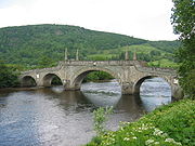 This road was built in 1730 by Wade. The bridge spanning the River Tay
at Aberfeldy and designed by William Adam, proved to be the single most expensive structure on the whole network, exceeding £4000 on its completion in 1734 some years after the remainder of the road.
The route leaves Crieff heading northeast across Crieff Golf Club and turns north at Gilmerton heading towards the Sma' Glen. Its line is approximated by the A822 road
; their routes coincide only in small part. It crosses the River Almond
at Newton Bridge and runs north to Amulree
where it crosses the River Braan
. The route initially takes a more westerly course than the modern A826 road through Glen Cochill before joining and leaving the modern route repeatedly then descending to its crossing of the Tay at Aberfeldy.
From Aberfeldy the route turned west along Strath Tay and then northwest beside the River Lyon before breaking northwards beside the Keltney Burn and Glen Goulandie heading for a crossing of the River Tummel
at Tummel Bridge - a route approximated by the modern B846 road. The road ran northwest from the bridge and around Drumcroy Hill to the remote hamlet of Trinafour
and a crossing of the Errochty Water. The final section ran north from here to join the Dunkeld to Inverness route at Dalnacardoch.
was built in 1731 by Wade. The initial part of the route which runs north from Dalwhinnie consists of numerous straight sections; its many sharp bends contribute to the reputation of the modern A889 road which follows it, as one of the most dangerous in Scotland. The connecting route from Ruthven ran west from the barracks through the upper part of Strathspey initially south of the river but then crossing it at Garva Bridge. Taking a rising line out of the valley of the Spey, and to the east of the Allt Yairack burn, it entered the bowl of Corrie Yairack and exited it by means of a series of tight zig-zags and over the exposed summit of the pass which lies at 750m above sea level. The route then drops northwestwards then north, remaining high above the deeply incised Glen Tarff
before a final descent into the Great Glen. Ironically the route may have served the Jacobite forces more effectively than government troops.
, Tarbet, Arrochar and Glen Croe
were not then completed until 1749. A stone seat was erected at the summit of the 860 feet (262.1 m) high pass at the head of Glen Croe bidding travellers to Rest and be thankful, hence the modern name. Subsequent maintenance was undertaken by the 93rd Regiment, the Sutherland Highlanders until in 1814 the route was handed over to the civilian authorities. William Wordsworth
was later to write of this road:
The route of this military road is now broadly followed by the A82
and A83
roads, partly on the original line, partly parallel to it.
was constructed between 1752 and 1754. Its route is approximated by a section of the modern A82 road
. A section which diverges more widely from the modern route at the Crianlarich end is now followed by the West Highland Way.
on the mainland shore opposite Skye
were constructed in the early 1720s. Caulfeild engineered the road through the West Highlands from Fort Augustus to Bernera Barracks in 1755 but Telford’s commissioners remade it in the 1820s. It initially headed west through Inchnacardoch Forest climbing to a height of over 1280 feet (390.1 m) before dropping into Glen Moriston. It appears to have crossed the River Moriston somewhere near the confluence of the River Doe with the Moriston, and then taken a route somewhat to the north of the present day A887 road and A87 road
north of Loch Cluanie
. The road descended Glen Shiel
to Ratagan
before rising over the Bealach Ratagain (Ratagan Pass) and into Glen More and thence to the barracks at its western, seaward end.
to Braemar by way of Spittal of Glenshee
was surveyed in 1748 and construction began in 1749. The continuation northwards via Corgarff, Grantown-on-Spey to Inverness did not begin until 1753. It would be the last of the major military roads to be built.
From Braemar
a road was constructed eastwards down the Dee valley
, crossing the river at Invercauld Bridge and continuing to the north bank to a point opposite Balmoral Castle
. This section is followed by a part of the modern A93 road
. It then ran northeastwards from the vicinity of Crathie on a line now followed, except in its southernmost part, by the B976 road. The road bridged the River Gairn at Gairnshiel and continued northwards over a high pass to Corgarff Castle
in the upper part of the Don
valley. The castle resulted from the government purchase in 1746 and subsequent fortification of one of the earl of Mar's hunting lodges. It was part of an attempt to reduce the incidence of cattle-rustling in the area.
The road ran northwest over the 2114 feet (644.3 m) high Lecht pass on an alignment largely followed by the modern A939 road
to the village of Tomintoul. From Tomintoul the road was constructed westwards to Grantown-on-Spey
and involved the bridging of two significant watercourses at Bridge of Avon and Bridge of Brown.
Beyond Grantown-on-Spey the road ran north and west, crossing the powerful River Findhorn
at Dulsie Bridge and continuing northwestwards to cross the River Nairn
west of Cawdor
. Only short sections of this are in use as modern roads. The final section ran on a straight alignment followed by the modern B9090 and B9006 roads to Ardersier
and Fort George.
in Galloway. The road passed through or by Dumfries
, Haugh of Urr
, Castle Douglas
, Bridge of Dee, Gatehouse of Fleet
, Creetown
, Newton Stewart
, Glenluce
and Stranraer
. It was constructed in the 1760s to assist in the movement of troops to Ireland, making use of sections of existing road. Much of its 105 miles (169 km) now lies under the modern A75 road
though other sections are now minor roads or tracks and some sections are entirely lost.
As the Jacobite threat receded towards the end of the 18th century so the need for upkeep of the roads for military purposes diminished. Some sections were abandoned entirely where they served little commercial use; travellers for example avoided the steeper sections which proved unsuitable for coaches. By 1790 only 600 miles (965.6 km) remained useable. In 1803, the Commissioners of Highland Roads and Bridges were established; it was they who assumed the responsibility for the maintenance and repair of the roads after the military relinquished its role.
The military road between Grantown and Fort George was not one of those whose subsequent repair fell to the Commissioners. Rather it was patched in a haphazard way by various landowners and authorities. As the original bridges on this route were washed away by winter floods so a variety of new ones were constructed.
The civilian road network was improved through the ninenteenth century by Thomas Telford
and others with many sections of Wade’s and Caulfeild’s roads being incorporated into it, though many more sections proved to be irrelevant to the needs of the wider population and fell into disuse. Miles of former road can now be traced stretching across country, either completely abandoned or serving as estate tracks or paths for walks and mountainbikers. In recent years some have been co-opted to form parts of both long distance paths such as the West Highland Way
or as parts of the growing National Cycle Network
. A number of sections of the military roads are protected as scheduled monuments for their archaeological value, including at the Corrieyairack Pass, and part of the Fort Augustus to Bernera road.
Scottish Highlands
The Highlands is an historic region of Scotland. The area is sometimes referred to as the "Scottish Highlands". It was culturally distinguishable from the Lowlands from the later Middle Ages into the modern period, when Lowland Scots replaced Scottish Gaelic throughout most of the Lowlands...
during the middle part of the 18th century as part of an attempt by the British Government to bring order to a part of the country which had risen up in the Jacobite rebellion of 1715.
The roads were constructed to link the Central Lowlands
Central Lowlands
The Central Lowlands or Midland Valley is a geologically defined area of relatively low-lying land in southern Scotland. It consists of a rift valley between the Highland Boundary Fault to the north and the Southern Uplands Fault to the south...
with a series of fortified barracks
Barracks
Barracks are specialised buildings for permanent military accommodation; the word may apply to separate housing blocks or to complete complexes. Their main object is to separate soldiers from the civilian population and reinforce discipline, training and esprit de corps. They were sometimes called...
located strategically across the Highlands. Their purpose much like the network of roads constructed by the Romans
Roman roads in Britain
Roman roads, together with Roman aqueducts and the vast standing Roman army , constituted the three most impressive features of the Roman Empire. In Britain, as in other provinces, the Romans constructed a comprehensive network of paved trunk roads Roman roads, together with Roman aqueducts and the...
more than one and a half millennia earlier was to suppress and exert control over the local population. The engineered roads of the Roman period did not extend into the Highlands whereas this was the very area where these later roads, which are subject of this article, were constructed.
The first four of these roads, were constructed in the 1720s and 1730s under the direction of General George Wade
George Wade
Field Marshal George Wade served as a British military commander and Commander-in-Chief of the Forces.-Early career:Wade, born in Kilavally, Westmeath in Ireland, was commissioned into the Earl of Bath's Regiment in 1690 and served in Flanders in 1692, during the Nine Years War, earning a...
and are commonly referred to as General Wade’s Military Roads or simply as Wade’s Roads.
The network was subsequently expanded considerably under the direction of Major William Caulfeild though his name is now largely forgotten and each of the roads that he had put in place are referred to, on Ordnance Survey
Ordnance Survey
Ordnance Survey , an executive agency and non-ministerial government department of the Government of the United Kingdom, is the national mapping agency for Great Britain, producing maps of Great Britain , and one of the world's largest producers of maps.The name reflects its creation together with...
mapping for example, simply as "Old Military Road". A further road was constructed by Caulfeild in southwest Scotland in the 1760s.
Wade’s Roads
Wade was sent to Scotland in July 1724. He reported back in December that "more than half of the 22,000 men capable of bearing arms in the Highlands and Islands were ready to create new troubles and rise in arms to favour the PretenderJames Francis Edward Stuart
James Francis Edward, Prince of Wales was the son of the deposed James II of England...
". In his report Wade pointed out that government troops would benefit from improved roads and river crossings to put down the rebels.
George I
George I of Great Britain
George I was King of Great Britain and Ireland from 1 August 1714 until his death, and ruler of the Duchy and Electorate of Brunswick-Lüneburg in the Holy Roman Empire from 1698....
appointed Wade as Commander-in-chief, North Britain. The first of four roads whose building Wade would oversee, was under construction by the following year;
- i) from InvernessInvernessInverness is a city in the Scottish Highlands. It is the administrative centre for the Highland council area, and is regarded as the capital of the Highlands of Scotland...
to Fort WilliamFort William, ScotlandFort William is the second largest settlement in the highlands of Scotland and the largest town: only the city of Inverness is larger.Fort William is a major tourist centre with Glen Coe just to the south, Aonach Mòr to the north and Glenfinnan to the west, on the Road to the Isles...
(along the south side of Loch Ness) - ii) from DunkeldDunkeldDunkeld is a small town in Strathtay, Perth and Kinross, Scotland. It is about 15 miles north of Perth on the eastern side of the A9 road into the Scottish Highlands and on the opposite side of the Tay from the Victorian village of Birnam. Dunkeld and Birnam share a railway station, on the...
to Inverness via Pass of DrumochterPass of DrumochterThe Pass of Drumochter is the main mountain pass between the northern and southern central Scottish Highlands. The A9 road passes through here, as does the Highland Main Line, the railway between Inverness and the south of Scotland... - iii) from CrieffCrieffCrieff is a market town in Perth and Kinross, Scotland. It lies on the A85 road between Perth and Crianlarich and also lies on the A822 between Greenloaning and Aberfeldy. The A822 joins onto the A823 which leads to Dunfermline....
to the existing road at Dalnacardoch by Aberfeldy and Tummel Bridge - iv) from DalwhinnieDalwhinnieDalwhinnie "Meeting Place" is a small village in the Scottish Highlands.-Location:Dalwhinnie sits at an altitude of 351 m. It is one of the coldest villages in the UK, having an average annual temperature of 6.5oC, making it suitable for winter walking and mountaineering.It is north of Drumochter,...
to Fort AugustusFort AugustusFort Augustus is a settlement in the Scottish Highlands, at the south west end of Loch Ness. The village has a population of around 646 ; its economy is heavily reliant on tourism....
via Corrieyairack PassCorrieyairack PassThe Corrieyairack Pass is an 770m high pass in the Scottish Highlands at .This pass would be relatively obscure were it not for General Wade's military road built over it in 1731, between Fort Augustus in the Great Glen to the north and Melgarve in Strath Spey in the south...
(and a spur to Ruthven via Crubenbeg)
The roads were built by the military at an average cost of £90/mile. Their standard width was 16 feet (4.9 m) but shrinking to 10 feet (3 m) as required. Construction took place between April/May and October of each year, the winter months being too harsh for such labours. Work in the summer could be arduous too with uncertain weather and the presence of the ubiquitous midge. The construction parties consisted of 100 men overseen by 2 corporals, 2 sergeants, 2 subalterns and a captain. They were generally also accompanied by a drummer. Wade engaged craftsmen with skills in masonry, carpentry for example to ensure that major structures such as bridges were built to a standard. Encampments were established at ten mile intervals and the inns which developed became known as Kingshouses. Some of these continue to serve travellers today. The well-known Kingshouse on Rannoch Moor
Rannoch Moor
Rannoch Moor is a large expanse of around 50 square miles of boggy moorland to the west of Loch Rannoch, in Perth and Kinross and Lochaber, Highland, partly northern Argyll and Bute, Scotland...
sits beside the route made by Wade's successor William Caulfeild.
Fort William to Inverness
Three forts were constructed by the British government along the length of the Great GlenGreat Glen
The Great Glen , also known as Glen Albyn or Glen More is a series of glens in Scotland running 100 kilometres from Inverness on the Moray Firth, to Fort William at the head of Loch Linnhe.The Great Glen follows a large geological fault known as the Great Glen Fault...
in the early 18th century. At its southwestern end was Fort William at the head of Loch Linnhe
Loch Linnhe
Loch Linnhe is a sea loch on the west coast of Scotland....
where the town of that name now stands. A second fort had been constructed in 1715 at the southern end of Loch Ness at Kilcumein. It was named Fort Augustus
Fort Augustus
Fort Augustus is a settlement in the Scottish Highlands, at the south west end of Loch Ness. The village has a population of around 646 ; its economy is heavily reliant on tourism....
after Prince William Augustus, Duke of Cumberland
Prince William Augustus, Duke of Cumberland
Prince William , was a younger son of George II of Great Britain and Caroline of Ansbach, and Duke of Cumberland from 1726. He is generally best remembered for his role in putting down the Jacobite Rising at the Battle of Culloden in 1746, and as such is also known as "Butcher" Cumberland...
. At its northeastern end, the original Fort George was constructed in Inverness - it was not until the destruction of that fort in the rebellion of 1746 that a replacement was constructed at Ardersier
Ardersier
Ardersier is a small former fishing village in the Scottish Highlands, on the Moray Firth, east of Inverness, near Fort George, and Nairn . Its name is an anglicisation of the Gaelic "Àird nan Saor", or "Headland of the joiners", one local legend being that carpenters working on the construction...
Point on the Moray Firth
Moray Firth
The Moray Firth is a roughly triangular inlet of the North Sea, north and east of Inverness, which is in the Highland council area of north of Scotland...
.
A route stretching the width of the Highlands from sea to sea was built by Wade during 1726 and 1727 to link the three forts. Before the completion of the northern section, and as a temporary measure, a galley operated on Loch Ness. It was withdrawn once the road was in place though it was later used in association with the construction of the Caledonian Canal
Caledonian Canal
The Caledonian Canal is a canal in Scotland that connects the Scottish east coast at Inverness with the west coast at Corpach near Fort William. It was constructed in the early nineteenth century by engineer Thomas Telford, and is a sister canal of the Göta Canal in Sweden, also constructed by...
.
The southern section takes a route eastwards from Fort Augustus along a line followed by the modern B862 road, crossing the Allt Doe, passing by Loch Tarff, entering Stratherrick
Stratherrick
Stratherrick is a strath, a wide and shallow valley, situated above the south-eastern shore of Loch Ness, in the Scottish Highlands, Scotland. Much of the strath is covered by Loch Mhòr...
and passing along the western shore of Loch Mhòr
Loch Mhòr
Loch Mhòr is a loch in the traditional county of Inverness-shire in the Scottish Highlands. It occupies much of the wide floor of Stratherrick which runs roughly parallel to Loch Ness around 3mi / 5km to its southeast. A generally shallow body of water, Loch Mhòr achieves a depth in excess of 20m...
. The alignment of Wade's route to the northeast of Loch Duntelchaig
Loch Duntelchaig
Loch Duntelchaig is a loch in the traditional county of Inverness-shire in the Scottish Highlands. It extends 5 km from the southwest to its outflow in the northeast and measures up to 1.75 km at its widest. The loch drains via Loch a Chlachain into the River Nairn. Loch Duntelchaig is...
is followed by minor roads today.
A new alignment of its northern section was constructed closer to the shores of Loch Ness in 1732. This route is followed by the modern B852 road between Inverness and Foyers
Foyers
Foyers is the name of a village in the Highland local government council area of Scotland, lying on the east shore of Loch Ness...
and joins the earlier line near Whitebridge.
Dunkeld to Inverness
Built between 1728 and 1730 by Wade. A report from Wade in July of 1728 refers to some 300 men working on the route of which 15 miles (24.1 km) had by then been completed.The route, followed by a minor road (formerly the A9
A9 road
The A9 is a major road running from the Falkirk council area in central Scotland to Thurso in the far north, via Stirling, Bridge of Allan, Perth and Inverness. At 273 miles , it is the longest road in Scotland and the fifth-longest A-road in the United Kingdom...
before the main road was diverted further west), ran west out of Dunkeld to the King's Pass and then turned north up the eastern side of Strath Tay. It continued north through Ballinluig
Ballinluig
Ballinluig is a village in Perth and Kinross, Scotland, with a population of approximately 240 . It lies on the banks of the River Tummel and is approximately 4 miles south-east of Pitlochry...
to Pitlochry
Pitlochry
Pitlochry , is a burgh in the council area of Perth and Kinross, Scotland, lying on the River Tummel. Its population according to the 2001 census was 2,564....
before squeezing through the Pass of Killiecrankie
Pass of Killiecrankie
Three miles north of Pitlochry by the A9 road, the Pass of Killiecrankie , is a mountain pass between 2757 ft Ben Vrackie and Tenandry Hill in Perth and Kinross on the River Garry....
into Glen Garry
River Garry, Perthshire
The River Garry is a major tributary of the River Tummel, itself a tributary of the River Tay, in the traditional county of Perthshire in the Scottish Highlands...
. It crossed the River Tilt at the Old Bridge of Tilt to the north of Blair Atholl
Blair Atholl
Blair Atholl is a small town in Perthshire, Scotland, built about the confluence of the Rivers Tilt and Garry in one of the few areas of flat land in the midst of the Grampian Mountains. The Gaelic place-name Blair, from blàr, 'field, plain', refers to this location...
. Parts of the route are still intact: past Dalnacardoch to the Pass of Drumochter
Pass of Drumochter
The Pass of Drumochter is the main mountain pass between the northern and southern central Scottish Highlands. The A9 road passes through here, as does the Highland Main Line, the railway between Inverness and the south of Scotland...
and Dalwhinnie
Dalwhinnie
Dalwhinnie "Meeting Place" is a small village in the Scottish Highlands.-Location:Dalwhinnie sits at an altitude of 351 m. It is one of the coldest villages in the UK, having an average annual temperature of 6.5oC, making it suitable for winter walking and mountaineering.It is north of Drumochter,...
; though other parts have been obliterated by the construction of the modern A9. From Glen Truim
River Truim
The River Truim is a right bank tributary of the River Spey in the Scottish Highlands. Its headwaters meet to the north of the Pass of Drumochter and flow northwards as the Truim past the dam at the northern end of Loch Ericht and through the village of Dalwhinnie, highest village in the Scottish...
the route ran to the east of the modern road via Glen Fernisdale, Phones and a crossing of the Milton Burn at Drochaid Tigh na Mile (now a ford) en route to the barracks at Ruthven
Ruthven Barracks
Ruthven Barracks near Ruthven, Highland in Scotland are the smallest but best preserved of the four barracks built in 1719 after the 1715 Jacobite rising, set on an old castle mound. It comprises two large three-storey blocks occupying two sides of the enclosure each with two rooms per floor...
near Kingussie
Kingussie
Kingussie is a small town in the Highland region of Scotland. It is one settlement in the Highland Council ward of Badenoch and Strathspey, and is the capital of the district of Badenoch. It lies beside the A9 road, although the old route of the A9 serves as the town's main street...
.
After crossing the River Spey
River Spey
The River Spey is a river in the northeast of Scotland, the second longest and the fastest-flowing river in Scotland...
the road ran along the western side of Strathspey
Strathspey, Scotland
Strathspey is the area around the strath of the River Spey, Scotland, in both the Moray council area and the Badenoch and Strathspey committee area of Highland....
via Kincraig
Kincraig
Kincraig is a village located north of Kingussie and south of Aviemore in Highland, Scotland. The village lies at the side of the former A9 road and 100 metres away from the current A9...
, Alvie
Alvie
Alvie is a small crofting hamlet and civil parish, located on the south shore of Loch Alvie in the Badenoch and Strathspey area of Inverness-shire, within the Scottish council area of Highland....
and Aviemore
Aviemore
Aviemore is a town and tourist resort, situated within the Cairngorms National Park in the Highlands of Scotland. It is in the Badenoch and Strathspey committee area, within the Highland council area. The town is popular for skiing and other winter sports, and for hill-walking in the Cairngorm...
to Kinveachy. Here it set out northwestwards, away from the modern roads, to cross the River Dulnain by means of the high stone arch of Sluggan Bridge - a crossing now used by the National Cycle Network. Wade took the road through the pass at The Slochd
Slochd Summit
The Slochd Summit is a mountain pass on the A9 road and the Highland Main Line Railway in the Scottish Highlands between Inverness and Aviemore. An old military road also goes through the pass...
just as the modern road does, and crossed the River Findhorn
River Findhorn
The River Findhorn is one of the longest rivers in Scotland. Located in the north east, it flows into the Moray Firth on the north coast. It has one of the largest non-firth estuaries in Scotland....
at Raigbeg. He chose to cross the River Nairn
River Nairn
The River Nairn is a river in the Scottish Highlands which rises in the Monadhliath Mountains and flows northeast through Strathnairn to enter the Moray Firth at Nairn. The headwaters of the Nairn, the Allt Mor and Cròm-allt Beag drop steeply down the western slopes of Carn Ghriogair, their...
at Bridge of Faillie before running the road a last few miles over Drummossie Muir to the barracks at Fort George, Inverness.
Crieff to Dalnarcardoch
River Tay
The River Tay is the longest river in Scotland and the seventh-longest in the United Kingdom. The Tay originates in western Scotland on the slopes of Ben Lui , then flows easterly across the Highlands, through Loch Dochhart, Loch Lubhair and Loch Tay, then continues east through Strathtay , in...
at Aberfeldy and designed by William Adam, proved to be the single most expensive structure on the whole network, exceeding £4000 on its completion in 1734 some years after the remainder of the road.
The route leaves Crieff heading northeast across Crieff Golf Club and turns north at Gilmerton heading towards the Sma' Glen. Its line is approximated by the A822 road
A822 road
The A822 is a road which runs through Perthshire in Scotland. It runs from the A9 road at Greenloaning, and rejoins the A9 at Dunkeld. It goes through Crieff and intersects the A85 road and the A823 road to Dunfermline....
; their routes coincide only in small part. It crosses the River Almond
River Almond, Perth and Kinross
The River Almond is a tributary of the River Tay in Perth and Kinross, Scotland. It rises in the hills to the south-east of Loch Tay, and flows eastwards through Glenalmond. It runs through the village of Almondbank, before joining the Tay immediately north of Perth. The river's course is around ...
at Newton Bridge and runs north to Amulree
Amulree
Amulree is a small hamlet in Perth and Kinross, Scotland. It lies in hilly country on the A822 road, 1 km east of Loch Freuchie in Strathbraan, 8 km west of Dunkeld and 10 km north of Crieff.Its parish church contains copies of records of the large number of people who stayed there...
where it crosses the River Braan
River Braan
The River Braan is a tributary of the River Tay in Scotland.Within the county of Perth and Kinross, it flows 11 miles eastwards from Loch Freuchie, near Amulree, and joins the River Tay near Dunkeld.-References:* - Geo.ed.ac.uk-External links:...
. The route initially takes a more westerly course than the modern A826 road through Glen Cochill before joining and leaving the modern route repeatedly then descending to its crossing of the Tay at Aberfeldy.
From Aberfeldy the route turned west along Strath Tay and then northwest beside the River Lyon before breaking northwards beside the Keltney Burn and Glen Goulandie heading for a crossing of the River Tummel
River Tummel
The River Tummel is a river in Perth and Kinross, Scotland. Discharging from Loch Rannoch, it flows east to a point near the Falls of Tummel, where it bends to the southeast, a direction which it maintains until it falls into the River Tay, just below Logierait, after a course of from its source...
at Tummel Bridge - a route approximated by the modern B846 road. The road ran northwest from the bridge and around Drumcroy Hill to the remote hamlet of Trinafour
Trinafour
Trinafour is a village in Perth and Kinross, Scotland, approximately seventeen miles north-west of Pitlochry, its nearest town. It is located at the western edge of Glen Errochty....
and a crossing of the Errochty Water. The final section ran north from here to join the Dunkeld to Inverness route at Dalnacardoch.
Dalwhinnie and Ruthven to Fort Augustus
This road whose most celebrated section runs over the Corrieyairack PassCorrieyairack Pass
The Corrieyairack Pass is an 770m high pass in the Scottish Highlands at .This pass would be relatively obscure were it not for General Wade's military road built over it in 1731, between Fort Augustus in the Great Glen to the north and Melgarve in Strath Spey in the south...
was built in 1731 by Wade. The initial part of the route which runs north from Dalwhinnie consists of numerous straight sections; its many sharp bends contribute to the reputation of the modern A889 road which follows it, as one of the most dangerous in Scotland. The connecting route from Ruthven ran west from the barracks through the upper part of Strathspey initially south of the river but then crossing it at Garva Bridge. Taking a rising line out of the valley of the Spey, and to the east of the Allt Yairack burn, it entered the bowl of Corrie Yairack and exited it by means of a series of tight zig-zags and over the exposed summit of the pass which lies at 750m above sea level. The route then drops northwestwards then north, remaining high above the deeply incised Glen Tarff
River Tarff, Fort Augustus
The River Tarff is a river in Inverness-shire in the Scottish Highlands. It rises between the hills of Gairbeinn and Geal Charn and flows northwards then southwestwards and finally north-northwestwards into the Great Glen where it enters Loch Ness at Fort Augustus. The middle and lower reaches of...
before a final descent into the Great Glen. Ironically the route may have served the Jacobite forces more effectively than government troops.
Caulfeild’s Roads
Wade himself retired in 1747 but not before his successor, Major William Caulfeild had been appointed to assist him as Inspector of Roads in 1732. Like Wade, Caulfeild was of Irish birth. He continued in the role until his death in 1767. It is Caulfeild who is credited with the lines:- Had you seen these roads before they were made.
- You would lift up your hands and bless General Wade.
Tyndrum to Fort William
The road was built in 1752 from Rannoch Moor over the ridge to Loch Leven and necessitated the construction of a spectacular series of zig-zags known as the Devil’s Staircase. The Crianlarich to Fort William section was constructed between 1749 and 1750.Rest and be Thankful
Construction of a road from Dumbarton to Inveraray was initiated under Caulfeild's command in 1743 but was then interrupted by the rebellion of 1745. Its 44 miles (70.8 km) which took it via the western side of Loch LomondLoch Lomond
Loch Lomond is a freshwater Scottish loch, lying on the Highland Boundary Fault. It is the largest lake in Great Britain by surface area. The lake contains many islands, including Inchmurrin, the largest fresh-water island in the British Isles, although the lake itself is smaller than many Irish...
, Tarbet, Arrochar and Glen Croe
Glen Croe
Glen Croe is a glen in the heart of the Arrochar Alps surrounded by large and rugged mountains characterised by huge boulders.-Geography:Glen Croe is located to the north west of Loch Lomond and Loch Long, draining into the latter. At the head of the glen is the pass leading to Glen Kinglas...
were not then completed until 1749. A stone seat was erected at the summit of the 860 feet (262.1 m) high pass at the head of Glen Croe bidding travellers to Rest and be thankful, hence the modern name. Subsequent maintenance was undertaken by the 93rd Regiment, the Sutherland Highlanders until in 1814 the route was handed over to the civilian authorities. William Wordsworth
William Wordsworth
William Wordsworth was a major English Romantic poet who, with Samuel Taylor Coleridge, helped to launch the Romantic Age in English literature with the 1798 joint publication Lyrical Ballads....
was later to write of this road:
- Doubling and doubling with laborious walk
- Who, that has gained at length
- The wished for Height
- This brief simple wayside. Call on slight,
- And rest not thankful?
The route of this military road is now broadly followed by the A82
A82 road
The A82 is a trunk road in Scotland. It is the principal route from Lowland Scotland to the western Scottish Highlands, running from Glasgow to Inverness, going by Loch Lomond, Glen Coe and Fort William. It is the second longest primary A-road in Scotland after the A9, which is the other...
and A83
A83 road
The A83 is a major road in Argyll and Bute, Scotland, running from Tarbet, on the western shore of Loch Lomond, where it splits from the A82, to Campbeltown at the southern end of the Kintyre peninsula.-Route:...
roads, partly on the original line, partly parallel to it.
Tarbet to Crianlarich
The military road between Tarbet and CrianlarichCrianlarich
Crianlarich is a village in the Stirling district and registration county of Perthshire, Scotland, about six miles north-east of the head of Loch Lomond...
was constructed between 1752 and 1754. Its route is approximated by a section of the modern A82 road
A82 road
The A82 is a trunk road in Scotland. It is the principal route from Lowland Scotland to the western Scottish Highlands, running from Glasgow to Inverness, going by Loch Lomond, Glen Coe and Fort William. It is the second longest primary A-road in Scotland after the A9, which is the other...
. A section which diverges more widely from the modern route at the Crianlarich end is now followed by the West Highland Way.
Fort Augustus to Bernera
The barracks at BerneraBernera Barracks
Bernera Barracks is located in Glenelg in the West Highlands of Scotland. The barracks were constructed between 1717 and 1723 as part of a campaign by the British government to subdue the local population which had risen up in arms in the Jacobite Rising of 1715, and which would do so again in 1745...
on the mainland shore opposite Skye
Skye
Skye or the Isle of Skye is the largest and most northerly island in the Inner Hebrides of Scotland. The island's peninsulas radiate out from a mountainous centre dominated by the Cuillin hills...
were constructed in the early 1720s. Caulfeild engineered the road through the West Highlands from Fort Augustus to Bernera Barracks in 1755 but Telford’s commissioners remade it in the 1820s. It initially headed west through Inchnacardoch Forest climbing to a height of over 1280 feet (390.1 m) before dropping into Glen Moriston. It appears to have crossed the River Moriston somewhere near the confluence of the River Doe with the Moriston, and then taken a route somewhat to the north of the present day A887 road and A87 road
A87 road
The A87 is a major road in the Highland region of Scotland.It runs west from its junction with the A82 road at Invergarry , along the north shores of Loch Garry and Loch Cluanie, then down through Glen Shiel and along Loch Duich to Kyle of Lochalsh before crossing the Skye Bridge to Kyleakin,...
north of Loch Cluanie
Loch Cluanie
Loch Cluanie is a loch in the Northwest Highlands of Scotland at the south-east end of Glen Shiel. It is a reservoir, contained behind the Cluanie Dam, constructed by Mitchell Construction and completed in 1957 as part of the North of Scotland Hydro-Electric Board's Glenmoriston project to...
. The road descended Glen Shiel
Glen Shiel
Glen Shiel is a glen in the Northwest Highlands of Scotland.The glen runs approximately 9 miles from north-west to south-east, from sea level at the village of Shiel Bridge and Loch Duich to the Cluanie Inn at the western end of Loch Cluanie and the start of Glenmoriston.W. H...
to Ratagan
Ratagan
Ratagan is a small hamlet on the southwestern shore of the sea loch, Loch Duich in Lochalsh, Scottish Highlands and is in the Scottish council area of Highland.The hamlet of Shiel Bridge lies 1 mile south east of the village....
before rising over the Bealach Ratagain (Ratagan Pass) and into Glen More and thence to the barracks at its western, seaward end.
Blairgowrie to Inverness
In connection with the construction of the new Fort George at Ardersier Point to the east of Inverness, Caulfeild was instructed to investigate a further, more easterly route between Inverness and Perth. A line from BlairgowrieBlairgowrie and Rattray
Blairgowrie and Rattray and Raitear is possibly from an English language cognate of Gaelic ràth, meaning fortress + a Pictish term cognate with Welsh tref, meaning settlement) is a twin burgh in Perth and Kinross, Scotland. Amongst locals, the town is colloquially known simply as "Blair"...
to Braemar by way of Spittal of Glenshee
Spittal of Glenshee
left|thumb|Standing stone at Spittal of GlensheeThe Spittal of Glenshee lies at the head of Glenshee in the highlands of eastern Perth and Kinross, Scotland where the confluence of many small streams flowing south out of the Grampians form the Shee Water...
was surveyed in 1748 and construction began in 1749. The continuation northwards via Corgarff, Grantown-on-Spey to Inverness did not begin until 1753. It would be the last of the major military roads to be built.
From Braemar
Braemar
Braemar is a village in Aberdeenshire, Scotland, around west of Aberdeen in the Highlands. It is the closest significantly-sized settlement to the upper course of the River Dee sitting at an altitude of ....
a road was constructed eastwards down the Dee valley
River Dee, Aberdeenshire
The River Dee is a river in Aberdeenshire, Scotland. It rises in the Cairngorms and flows through Strathdee to reach the North Sea at Aberdeen...
, crossing the river at Invercauld Bridge and continuing to the north bank to a point opposite Balmoral Castle
Balmoral Castle
Balmoral Castle is a large estate house in Royal Deeside, Aberdeenshire, Scotland. It is located near the village of Crathie, west of Ballater and east of Braemar. Balmoral has been one of the residences of the British Royal Family since 1852, when it was purchased by Queen Victoria and her...
. This section is followed by a part of the modern A93 road
A93 road
The A93 is a major road in Scotland and the highest public road in the United Kingdom. It runs north from Perth through Blairgowrie and Rattray, then through the Grampian Mountains by way of Glenshee, the Cairnwell Pass and Glen Clunie to Braemar in Aberdeenshire...
. It then ran northeastwards from the vicinity of Crathie on a line now followed, except in its southernmost part, by the B976 road. The road bridged the River Gairn at Gairnshiel and continued northwards over a high pass to Corgarff Castle
Corgarff Castle
Corgarff Castle is a castle in Corgarff, Aberdeenshire, Scotland.Through much of its history Corgarff has been of strategic importance, guarding the quickest route from Deeside to Speyside, a route later followed by the military road from Blairgowrie to Fort George...
in the upper part of the Don
River Don, Aberdeenshire
The River Don is a river in north-east Scotland. It rises in the Grampians and flows eastwards, through Aberdeenshire, to the North Sea at Aberdeen. The Don passes through Alford, Kemnay, Inverurie, Kintore, and Dyce...
valley. The castle resulted from the government purchase in 1746 and subsequent fortification of one of the earl of Mar's hunting lodges. It was part of an attempt to reduce the incidence of cattle-rustling in the area.
The road ran northwest over the 2114 feet (644.3 m) high Lecht pass on an alignment largely followed by the modern A939 road
A939 road
The A939 'Lecht Road' connects the A96 at Nairn on the Moray Coast with the A95 Grantown on Spey, then it continues to the A93 at Ballater by way of the Grampian Mountains, passing Tomintoul and the Lecht Ski Centre.This road passes over four summits:...
to the village of Tomintoul. From Tomintoul the road was constructed westwards to Grantown-on-Spey
Grantown-on-Spey
Grantown-on-Spey is a town in the Highland Council Area in Scotland.It was founded in 1765 as a planned settlement on a low plateau at Freuchie beside the river Spey at the northern edge of the Cairngorm mountains, about 20 miles South East of Inverness .It is the main town in what was the...
and involved the bridging of two significant watercourses at Bridge of Avon and Bridge of Brown.
Beyond Grantown-on-Spey the road ran north and west, crossing the powerful River Findhorn
River Findhorn
The River Findhorn is one of the longest rivers in Scotland. Located in the north east, it flows into the Moray Firth on the north coast. It has one of the largest non-firth estuaries in Scotland....
at Dulsie Bridge and continuing northwestwards to cross the River Nairn
River Nairn
The River Nairn is a river in the Scottish Highlands which rises in the Monadhliath Mountains and flows northeast through Strathnairn to enter the Moray Firth at Nairn. The headwaters of the Nairn, the Allt Mor and Cròm-allt Beag drop steeply down the western slopes of Carn Ghriogair, their...
west of Cawdor
Cawdor
Cawdor is a village and parish in Nairnshire, Highland council area, Scotland. The village is situated 5 miles south south west of Nairn, and 12 miles from Inverness.-History:The village is the location of Cawdor Castle, the seat of the Earl Cawdor....
. Only short sections of this are in use as modern roads. The final section ran on a straight alignment followed by the modern B9090 and B9006 roads to Ardersier
Ardersier
Ardersier is a small former fishing village in the Scottish Highlands, on the Moray Firth, east of Inverness, near Fort George, and Nairn . Its name is an anglicisation of the Gaelic "Àird nan Saor", or "Headland of the joiners", one local legend being that carpenters working on the construction...
and Fort George.
Bridge of Sark to Portpatrick
Caulfeild also constructed a military road from Bridge of Sark west to Port Patrick on the east coast of the North ChannelNorth Channel (Great Britain and Ireland)
The North Channel is the strait which separates eastern Northern Ireland from southwestern Scotland...
in Galloway. The road passed through or by Dumfries
Dumfries
Dumfries is a market town and former royal burgh within the Dumfries and Galloway council area of Scotland. It is near the mouth of the River Nith into the Solway Firth. Dumfries was the county town of the former county of Dumfriesshire. Dumfries is nicknamed Queen of the South...
, Haugh of Urr
Haugh of Urr
Haugh of Urr, is a village in the Urr parish, Kirkcudbrightshire, in South West Scotland. It is approximately NNW of Dalbeattie, NE of Castle Douglas, 12½ miles west of Dumfries and 12½ miles east of Kirkcudbright. It is pronounced hoch of ur, with Haugh rhyming with the Scottish pronunciation of...
, Castle Douglas
Castle Douglas
Castle Douglas , a town in the south of Scotland in Dumfries and Galloway, lies in the eastern part of Galloway known as the Stewartry, between the towns of Dalbeattie and Gatehouse of Fleet.-History:...
, Bridge of Dee, Gatehouse of Fleet
Gatehouse of Fleet
Gatehouse of Fleet is a town in Dumfries and Galloway, Scotland, which has existed since the mid-18th century, although the area has been inhabited since much earlier...
, Creetown
Creetown
Creetown is a small seaport town in the Stewartry of Kirkcudbright, which forms part of the Galloway in the Dumfries and Galloway council area in south-west Scotland. Its population is about 750 people. It is situated near the head of Wigtown Bay, 18 mi. west of Castle Douglas...
, Newton Stewart
Newton Stewart
Newton Stewart is a burgh town in the south of Scotland in the west of the region of Dumfries and Galloway and in the county of Wigtownshire....
, Glenluce
Glenluce
Glenluce is a village in the Scottish area of Dumfries and Galloway.Located on the A75 road between Stranraer and Newton Stewart it is in the traditional county of Wigtownshire. Glenluce Abbey is nearby at ....
and Stranraer
Stranraer
Stranraer is a town in the southwest of Scotland. It lies in the west of Dumfries and Galloway and in the county of Wigtownshire.Stranraer lies on the shores of Loch Ryan on the northern side of the isthmus joining the Rhins of Galloway to the mainland...
. It was constructed in the 1760s to assist in the movement of troops to Ireland, making use of sections of existing road. Much of its 105 miles (169 km) now lies under the modern A75 road
A75 road
The A75 is a major road in Scotland, heading west along the south coast of Scotland from its junction with the A74 motorway at Gretna. It continues past Eastriggs, Annan, Dumfries, Castle Douglas, Gatehouse of Fleet, Newton Stewart and Glenluce before ending at Stranraer.The majority of the road...
though other sections are now minor roads or tracks and some sections are entirely lost.
Subsequent history
The highland road building programme ceased with Caulfeild’s death in 1767 with some 1100 miles (1,770.3 km) having been constructed. Wade was responsible for 300 of these, Caulfeild for the remaining 800.As the Jacobite threat receded towards the end of the 18th century so the need for upkeep of the roads for military purposes diminished. Some sections were abandoned entirely where they served little commercial use; travellers for example avoided the steeper sections which proved unsuitable for coaches. By 1790 only 600 miles (965.6 km) remained useable. In 1803, the Commissioners of Highland Roads and Bridges were established; it was they who assumed the responsibility for the maintenance and repair of the roads after the military relinquished its role.
The military road between Grantown and Fort George was not one of those whose subsequent repair fell to the Commissioners. Rather it was patched in a haphazard way by various landowners and authorities. As the original bridges on this route were washed away by winter floods so a variety of new ones were constructed.
The civilian road network was improved through the ninenteenth century by Thomas Telford
Thomas Telford
Thomas Telford FRS, FRSE was a Scottish civil engineer, architect and stonemason, and a noted road, bridge and canal builder.-Early career:...
and others with many sections of Wade’s and Caulfeild’s roads being incorporated into it, though many more sections proved to be irrelevant to the needs of the wider population and fell into disuse. Miles of former road can now be traced stretching across country, either completely abandoned or serving as estate tracks or paths for walks and mountainbikers. In recent years some have been co-opted to form parts of both long distance paths such as the West Highland Way
West Highland Way
The West Highland Way is a linear long distance footpath in Scotland, with the official status of Long Distance Route. It is 154.5km long, running from Milngavie north of Glasgow to Fort William in the Scottish Highlands, with an element of hill walking in the route...
or as parts of the growing National Cycle Network
National Cycle Network
The National Cycle Network is a network of cycle routes in the United Kingdom.The National Cycle Network was created by the charity Sustrans , and aided by a £42.5 million National Lottery grant. In 2005 it was used for over 230 million trips.Many routes hope to minimise contact with motor...
. A number of sections of the military roads are protected as scheduled monuments for their archaeological value, including at the Corrieyairack Pass, and part of the Fort Augustus to Bernera road.
External links
- Pathfinder Pack on General Wade's Military Roads and Forts, Resources for Learning in Scotland