
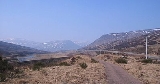
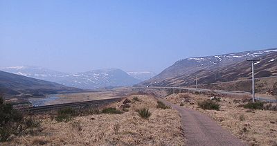
Pass of Drumochter
Encyclopedia
Mountain pass
A mountain pass is a route through a mountain range or over a ridge. If following the lowest possible route, a pass is locally the highest point on that route...
between the northern and southern central Scottish Highlands
Scottish Highlands
The Highlands is an historic region of Scotland. The area is sometimes referred to as the "Scottish Highlands". It was culturally distinguishable from the Lowlands from the later Middle Ages into the modern period, when Lowland Scots replaced Scottish Gaelic throughout most of the Lowlands...
. The A9 road passes through here, as does the Highland Main Line
Highland Main Line
The Highland Main Line is a railway line in Scotland. It is long and runs through the Scottish Highlands linking a series of small towns and villages with Perth at one end and Inverness at the other. Today, services between Inverness and Edinburgh, Glasgow and London use the line...
, the railway between Inverness
Inverness
Inverness is a city in the Scottish Highlands. It is the administrative centre for the Highland council area, and is regarded as the capital of the Highlands of Scotland...
and the south of Scotland
Scotland
Scotland is a country that is part of the United Kingdom. Occupying the northern third of the island of Great Britain, it shares a border with England to the south and is bounded by the North Sea to the east, the Atlantic Ocean to the north and west, and the North Channel and Irish Sea to the...
. The Sustrans
Sustrans
Sustrans is a British charity to promote sustainable transport. The charity is currently working on a number of practical projects to encourage people to walk, cycle and use public transport, to give people the choice of "travelling in ways that benefit their health and the environment"...
National Cycle Route 7
NCR 7
-Route:For mapping purposes, the route is split at Glasgow into Lochs and Glens and -Carlisle to Glasgow:The route runs from Carlisle across the border to Dumfries; this section takes a long route at present, but may change following the construction of an "all-purpose route" alongside the M6...
between Glasgow and Inverness also runs through the pass.
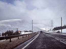
It is the high point on the A9, at 460m (1508 ft.), and in winter can be subject to severe weather conditions. Routine winter patrols take place between November and March and the road is occasionally closed with snow gates near Dalwhinnie
Dalwhinnie
Dalwhinnie "Meeting Place" is a small village in the Scottish Highlands.-Location:Dalwhinnie sits at an altitude of 351 m. It is one of the coldest villages in the UK, having an average annual temperature of 6.5oC, making it suitable for winter walking and mountaineering.It is north of Drumochter,...
and Dalnacardoch. The summit of the railway line is 452m (1480 ft.), making it the highest in the UK. The route through the pass has been used since prehistoric
Prehistoric Scotland
Archaeology and geology continue to reveal the secrets of prehistoric Scotland, uncovering a complex and dramatic past before the Romans brought Scotland into the scope of recorded history...
times. It is used by the RAF as a main route for low level flying and Tornado
Panavia Tornado
The Panavia Tornado is a family of twin-engine, variable-sweep wing combat aircraft, which was jointly developed and manufactured by the United Kingdom, West Germany and Italy...
s and other fast jets may often be seen here.
The pass was formed by glacial action during successive Ice Age
Ice age
An ice age or, more precisely, glacial age, is a generic geological period of long-term reduction in the temperature of the Earth's surface and atmosphere, resulting in the presence or expansion of continental ice sheets, polar ice sheets and alpine glaciers...
s. From this place the River Garry
River Garry, Perthshire
The River Garry is a major tributary of the River Tummel, itself a tributary of the River Tay, in the traditional county of Perthshire in the Scottish Highlands...
flows to the south, and the River Truim
River Truim
The River Truim is a right bank tributary of the River Spey in the Scottish Highlands. Its headwaters meet to the north of the Pass of Drumochter and flow northwards as the Truim past the dam at the northern end of Loch Ericht and through the village of Dalwhinnie, highest village in the Scottish...
to the north.
It is extremely isolated, and the nearest settlement of any size is Dalwhinnie, a small village.
The highest point on the pass marks the boundary between Perth and Kinross
Perth and Kinross
Perth and Kinross is one of 32 council areas in Scotland, and a Lieutenancy Area. It borders onto the Aberdeenshire, Angus, Dundee City, Fife, Clackmannanshire, Stirling, Argyll and Bute and Highland council areas. Perth is the administrative centre...
and the Highland Council area. A sign at this point says "Welcome to the Highlands/Fàilte don Ghàidhealtachd", although this is the boundary for the authority rather than for the Scottish highlands
Scottish Highlands
The Highlands is an historic region of Scotland. The area is sometimes referred to as the "Scottish Highlands". It was culturally distinguishable from the Lowlands from the later Middle Ages into the modern period, when Lowland Scots replaced Scottish Gaelic throughout most of the Lowlands...
which extend further south of here.