

Newark Basin
Encyclopedia
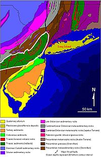
The Newark Basin is a sediment
-filled rift basin
located mainly in northern New Jersey
but also stretching into south-eastern Pennsylvania
and southern New York
. It is part of the system of Eastern North America Rift Basins
.
 Approximately 220 million years ago, during the late Triassic
Period, the supercontinent
Pangaea
began to break apart. The focus of the rifting began somewhere between where present-day eastern North America
and north-western Africa
were joined.
As in all rifting environments, graben
s formed. Many of these grabens were created, but for some of them, extension stopped before full rifting occurred. Where only partial rifting occurred, basins
formed, analogous to the present-day Basin and Range Province
in western United States. By definition, a basin is any area that collects sediments. These "aborted rifts" (rifts that are tectonically
inactive and no longer collecting sediments) extend from North Carolina
to Newfoundland.
Along certain basins, rifting was not partial. Where full rifting occurred, the Atlantic Ocean
was created. It is important to note that along these rifts, magmatic activity never stopped, as shown by the ongoing eruption of lava along the Mid-Atlantic Ridge.
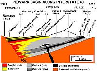 The Newark Basin is one in a series of these failed rifts. It is a half-graben filled over time by characteristic red bed sediments, sediments eroded from the uplifted footwalls of the border faults that were deposited within the basin; they are red due to their abundance in oxidized iron oxide minerals. The border fault is the Ramapo Fault
on the western boundary of the basin; this is where the hanging wall of the graben slid down to its current position. Estimates to the depth of accumulated sediments on the western side of the basin, and therefore the depth of the hanging wall, are in the area of 11,000 feet. The beds dip
roughly 15 degrees to the west throughout the basin. Though the north-eastern end of the basin is well-defined (it ends at the Hudson River
), the south-western "end" is not an end at all, but merely a narrowing where the graben then re-opens into the Gettysburg Basin.
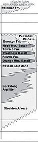 A significant geological feature within the Newark Basin is the Palisades Sill
. During rifting events, magmatism
is common due to decompression melting. The Palisades Sill is a result of this process.
Sediment
Sediment is naturally occurring material that is broken down by processes of weathering and erosion, and is subsequently transported by the action of fluids such as wind, water, or ice, and/or by the force of gravity acting on the particle itself....
-filled rift basin
Rift
In geology, a rift or chasm is a place where the Earth's crust and lithosphere are being pulled apart and is an example of extensional tectonics....
located mainly in northern New Jersey
New Jersey
New Jersey is a state in the Northeastern and Middle Atlantic regions of the United States. , its population was 8,791,894. It is bordered on the north and east by the state of New York, on the southeast and south by the Atlantic Ocean, on the west by Pennsylvania and on the southwest by Delaware...
but also stretching into south-eastern Pennsylvania
Pennsylvania
The Commonwealth of Pennsylvania is a U.S. state that is located in the Northeastern and Mid-Atlantic regions of the United States. The state borders Delaware and Maryland to the south, West Virginia to the southwest, Ohio to the west, New York and Ontario, Canada, to the north, and New Jersey to...
and southern New York
New York
New York is a state in the Northeastern region of the United States. It is the nation's third most populous state. New York is bordered by New Jersey and Pennsylvania to the south, and by Connecticut, Massachusetts and Vermont to the east...
. It is part of the system of Eastern North America Rift Basins
Eastern North America Rift Basins
The Eastern North America Rift Basins are a series of sediment-filled depressions created by large-scale continental extension. Their positions closely mirror the eastern coast of North America.-Geology:...
.
Geology
Triassic
The Triassic is a geologic period and system that extends from about 250 to 200 Mya . As the first period of the Mesozoic Era, the Triassic follows the Permian and is followed by the Jurassic. Both the start and end of the Triassic are marked by major extinction events...
Period, the supercontinent
Supercontinent
In geology, a supercontinent is a landmass comprising more than one continental core, or craton. The assembly of cratons and accreted terranes that form Eurasia qualifies as a supercontinent today.-History:...
Pangaea
Pangaea
Pangaea, Pangæa, or Pangea is hypothesized as a supercontinent that existed during the Paleozoic and Mesozoic eras about 250 million years ago, before the component continents were separated into their current configuration....
began to break apart. The focus of the rifting began somewhere between where present-day eastern North America
North America
North America is a continent wholly within the Northern Hemisphere and almost wholly within the Western Hemisphere. It is also considered a northern subcontinent of the Americas...
and north-western Africa
Africa
Africa is the world's second largest and second most populous continent, after Asia. At about 30.2 million km² including adjacent islands, it covers 6% of the Earth's total surface area and 20.4% of the total land area...
were joined.
As in all rifting environments, graben
Graben
In geology, a graben is a depressed block of land bordered by parallel faults. Graben is German for ditch. Graben is used for both the singular and plural....
s formed. Many of these grabens were created, but for some of them, extension stopped before full rifting occurred. Where only partial rifting occurred, basins
Sedimentary basin
The term sedimentary basin is used to refer to any geographical feature exhibiting subsidence and consequent infilling by sedimentation. As the sediments are buried, they are subjected to increasing pressure and begin the process of lithification...
formed, analogous to the present-day Basin and Range Province
Basin and Range
The Basin and Range Province is a vast physiographic region defined by a unique topographic expression. Basin and Range topography is characterized by abrupt changes in elevation, alternating between narrow faulted mountain chains and flat arid valleys or basins...
in western United States. By definition, a basin is any area that collects sediments. These "aborted rifts" (rifts that are tectonically
Plate tectonics
Plate tectonics is a scientific theory that describes the large scale motions of Earth's lithosphere...
inactive and no longer collecting sediments) extend from North Carolina
North Carolina
North Carolina is a state located in the southeastern United States. The state borders South Carolina and Georgia to the south, Tennessee to the west and Virginia to the north. North Carolina contains 100 counties. Its capital is Raleigh, and its largest city is Charlotte...
to Newfoundland.
Along certain basins, rifting was not partial. Where full rifting occurred, the Atlantic Ocean
Atlantic Ocean
The Atlantic Ocean is the second-largest of the world's oceanic divisions. With a total area of about , it covers approximately 20% of the Earth's surface and about 26% of its water surface area...
was created. It is important to note that along these rifts, magmatic activity never stopped, as shown by the ongoing eruption of lava along the Mid-Atlantic Ridge.
Ramapo Fault
The Ramapo Fault zone, spanning more than 185 miles in New York, New Jersey, and Pennsylvania, is a system of faults between the northern Appalachian Mountains and Piedmont areas to the east. This fault is perhaps the best known fault zone in the Mid-Atlantic region, and some small earthquakes...
on the western boundary of the basin; this is where the hanging wall of the graben slid down to its current position. Estimates to the depth of accumulated sediments on the western side of the basin, and therefore the depth of the hanging wall, are in the area of 11,000 feet. The beds dip
Strike and dip
Strike and dip refer to the orientation or attitude of a geologic feature. The strike line of a bed, fault, or other planar feature is a line representing the intersection of that feature with a horizontal plane. On a geologic map, this is represented with a short straight line segment oriented...
roughly 15 degrees to the west throughout the basin. Though the north-eastern end of the basin is well-defined (it ends at the Hudson River
Hudson River
The Hudson is a river that flows from north to south through eastern New York. The highest official source is at Lake Tear of the Clouds, on the slopes of Mount Marcy in the Adirondack Mountains. The river itself officially begins in Henderson Lake in Newcomb, New York...
), the south-western "end" is not an end at all, but merely a narrowing where the graben then re-opens into the Gettysburg Basin.
Palisades Sill
The Palisades Sill is a Triassic, 200 Ma diabase intrusion. It extends through portions of New York and New Jersey. It is most noteworthy for The Palisades, the cliffs that rise steeply above the western bank of the Hudson River...
. During rifting events, magmatism
Magmatism
The formation of igneous rocks from magma is known as Magmatism.Magmatism is a process responsible for mountain formation. The process of magmatism produces an additional mass and volume to the Earth’s surface. For example the formation of volcanoes or island arcs at convergent plate boundaries...
is common due to decompression melting. The Palisades Sill is a result of this process.