

Phantom island
Encyclopedia
Island
An island or isle is any piece of sub-continental land that is surrounded by water. Very small islands such as emergent land features on atolls can be called islets, cays or keys. An island in a river or lake may be called an eyot , or holm...
s that were believed to exist, and appeared on maps for a period of time (sometimes centuries) during recorded history
Recorded history
Recorded history is the period in history of the world after prehistory. It has been written down using language, or recorded using other means of communication. It starts around the 4th millennium BC, with the invention of writing.-Historical accounts:...
, but were later removed after they were proved to be nonexistent. In contrast, lost lands
Lost lands
Lost lands can be continents, islands or other regions supposedly existing during prehistory, having since disappeared as a result of catastrophic geological phenomena or slowly rising sea levels since the end of the last Ice Age. Lost lands, where they existed, are supposed to have subsided into...
are islands or continents believed by some to have existed during prehistory
Prehistory
Prehistory is the span of time before recorded history. Prehistory can refer to the period of human existence before the availability of those written records with which recorded history begins. More broadly, it refers to all the time preceding human existence and the invention of writing...
, often associated with ancient myths and legends; and vanishing island
Vanishing island
Vanishing island refers to any permanent island which is exposed at low tide but is submersed at high tide. Vanishing islands occur globally. There are seven vanishing islands in the Philippines and several in the San Juan Islands.-Cryptozoology:...
s are islands that are submerged during high tide
High Tide
High Tide was a band formed in 1969 by Tony Hill , Simon House , Peter Pavli and Roger Hadden .-History:...
.
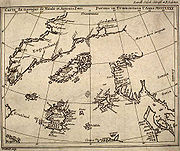
Phantom islands usually stem from the reports of early sailors exploring new realms. Some arose through the mislocation of actual islands, or other errors in geography. For instance, Pepys Island
Pepys Island
Pepys Island is a phantom island, said to lie about north of the Falkland Islands in 47°S. It was first described by Ambrose Cowley in 1684, presumably mistaking the coordinates of one of the Falkland Islands, and named by him for Samuel Pepys, Secretary of the Admiralty. Other observers on the...
was actually a misidentification of the Falkland Islands
Falkland Islands
The Falkland Islands are an archipelago in the South Atlantic Ocean, located about from the coast of mainland South America. The archipelago consists of East Falkland, West Falkland and 776 lesser islands. The capital, Stanley, is on East Falkland...
. The Baja California peninsula
Baja California Peninsula
The Baja California peninsula , is a peninsula in northwestern Mexico. Its land mass separates the Pacific Ocean from the Gulf of California. The Peninsula extends from Mexicali, Baja California in the north to Cabo San Lucas, Baja California Sur in the south.The total area of the Baja California...
appears on some early maps as an island but was later discovered to be attached to the mainland of North America
North America
North America is a continent wholly within the Northern Hemisphere and almost wholly within the Western Hemisphere. It is also considered a northern subcontinent of the Americas...
. Thule
Thule
Thule Greek: Θούλη, Thoulē), also spelled Thula, Thila, or Thyïlea, is, in classical European literature and maps, a region in the far north. Though often considered to be an island in antiquity, modern interpretations of what was meant by Thule often identify it as Norway. Other interpretations...
was perhaps actually discovered in the 4th century BC but was lost, and then later reidentified by ancient explorers and geographers as Shetland, Iceland
Iceland
Iceland , described as the Republic of Iceland, is a Nordic and European island country in the North Atlantic Ocean, on the Mid-Atlantic Ridge. Iceland also refers to the main island of the country, which contains almost all the population and almost all the land area. The country has a population...
, Scandinavia
Scandinavia
Scandinavia is a cultural, historical and ethno-linguistic region in northern Europe that includes the three kingdoms of Denmark, Norway and Sweden, characterized by their common ethno-cultural heritage and language. Modern Norway and Sweden proper are situated on the Scandinavian Peninsula,...
, or even as nonexistent.
Other phantom islands are probably due to navigational errors, the misidentification of icebergs, fog banks, or to optical illusions. New South Greenland
New South Greenland
New South Greenland, sometimes known as Morrell's Land, was an appearance of land recorded by the American captain Benjamin Morrell of the schooner Wasp in , during a sealing and exploration voyage in the Weddell Sea area of Antarctica. Morrell provided precise coordinates and a description of a...
, observed in the Weddell Sea in 1823 but never again seen, may have been the result of a superior mirage, though other explanations, including icebergs, misnavigation and even fabrication have been suggested.
Some "errors" were later thought to be intentional. Lake Superior
Lake Superior
Lake Superior is the largest of the five traditionally-demarcated Great Lakes of North America. It is bounded to the north by the Canadian province of Ontario and the U.S. state of Minnesota, and to the south by the U.S. states of Wisconsin and Michigan. It is the largest freshwater lake in the...
's Isles Phelipeaux and Pontchartrain
Isles Phelipeaux and Pontchartrain
Isle Phelipeaux and Isle Pontchartrain are phantom islands inLake Superior, believed at one time to be real, shown on early maps, such as the Mitchell Map, of...
, which appeared on explorers' maps for many years, were named for Louis Phélypeaux, marquis de La Vrilliere, comte de Pontchartrain. Phélypeaux was a government minister influential in allocating funds for additional voyages of exploration.
While many phantom islands appear never to have existed, a few (such as, perhaps, Thompson Island or Bermeja
Bermeja
Bermeja is an islet lying off the north coast of the Yucatán peninsula according to several maps of the Gulf of Mexico from the 16th to the 19th centuries...
) may have been actual islands subsequently destroyed by volcanic explosions, earthquakes or submarine landslides, or low-lying lands such as sand bank
Shoal
Shoal, shoals or shoaling may mean:* Shoal, a sandbank or reef creating shallow water, especially where it forms a hazard to shipping* Shoal draught , of a boat with shallow draught which can pass over some shoals: see Draft...
s that are no longer above water.
List of Phantom Islands
- AntilliaAntilliaAntillia is a legendary island that was reputed, during the 15th century age of exploration, to lie in the Atlantic Ocean, far to the west of Portugal and Spain...
- Aurora IslandsAurora IslandsThe Aurora Islands was a group of three phantom islands first reported in 1762 by the Spanish merchant ship Aurora while sailing from Lima to Cádiz. The Aurora's officers reported sighting them again in 1774. The Spanish ship San Miguel fixed their location at 52°37'S, 47°49'W...
- BacalaoBacalaoBacallao was a phantom island depicted on several early 16th century maps and nautical charts. The name first appears on a chart in 1508, but there are earlier accounts of Bacalao...
- Baja California peninsulaBaja California PeninsulaThe Baja California peninsula , is a peninsula in northwestern Mexico. Its land mass separates the Pacific Ocean from the Gulf of California. The Peninsula extends from Mexicali, Baja California in the north to Cabo San Lucas, Baja California Sur in the south.The total area of the Baja California...
- BermejaBermejaBermeja is an islet lying off the north coast of the Yucatán peninsula according to several maps of the Gulf of Mexico from the 16th to the 19th centuries...
- Brasil
- St. Brendan's IslandSt. Brendan's IslandSituated somewhere west of Northern Africa, St. Brendan’s Isle is a phantom island often regarded as myth, since, unless it is the so-called "Eighth Canary Island" known since time immemorial to the Spanish and Portuguese authorities as San Borondón, only a few have claimed to have seen it.In the...
- Buss IslandBuss IslandBuss Island is a phantom island. It was recorded as discovered during the third expedition of Martin Frobisher in September 1578 by sailors aboard the Emmanuel and was indicated on maps as existing between Ireland and mythical Frisland at about 57° N. The island was named after the type of vessel...
- Crockerland
- Isle of DemonsIsle of DemonsThe Isle of Demons is a legendary land once believed to exist near Newfoundland. It was generally shown as two islands. It began appearing on maps in the beginning of the 16th century, and disappeared in the mid-17th century....
- Dougherty Island
- Emerald IslandEmerald Island (phantom)The Emerald Island is a phantom island reported to lie between Australia and Antarctica and south of Macquarie Island. It was first sighted by the British sealing ship Emerald, captained by William Elliot, in December 1821, and the name of the presumed island derives from the name of this ship...
- Ernest Legouve ReefErnest Legouve ReefLocated in the South Pacific Ernest‑Legouvé Reef was reported in 1902 by the unnamed captain of the French ship "Ernest‑Legouvé". The reef was about 100 metres long and another reef was sighted near it...
- EstotilandEstotilandEstotiland is a region of land appearing on the Zeno map, ostensibly on the western side of the Atlantic Ocean in the location of Labrador. The map on which it appears was purportedly made in the early 15th century by Antonio Zeno...
- Filippo ReefFilippo ReefFilippo Reef is a reef that is asserted to be located in the Pacific Ocean at , 450 km east of Starbuck Island in the Line Islands, which was reported by the master of the Italian barque Filippo as having been seen on 28 June 1886...
- FrislandFrislandFrisland, also called Frischlant, Friesland, Freezeland, Frislandia, or Fixland, is a mythical island that appeared on virtually all of the maps of the North Atlantic from the 1560s through the 1660s...
- Ganges Island
- GroclantGroclantGroclant is the name of a phantom island generally shown off the western side of Greenland, first appearing on maps in the late 16th century....
- Los JardinesLos JardinesTwo phantom islands located east of the Marshall Islands, visited by Alavaro de Saavedra in 1528 and by Ruy López de Villalobos in 1542.-See also:* 1932 German map showing Los Jardines northeast of the Marianas, northwest of the Marshalls...
- Jacquet IslandJacquet IslandJacquet Island was a phantom island charted at about in the North Atlantic. Belief in its existence continued into the 19th century, when it was discussed as a possible midway point for the transatlantic telegraph cable....
- Jupiter ReefJupiter ReefJupiter Reef or Jupiter Breakers is a supposed reef in the South Pacific ; it appears to be a phantom reef....
- Isle of MamMaydaMayda is a non-existent island in the North Atlantic that has been shown on several published maps at various points in history. It was most often represented as being crescent-shaped and its position has varied widely over time...
- Maria Theresa ReefMaria Theresa ReefThe Maria-Theresa Reef is a supposed reef in the South Pacific ; it appears to be a phantom reef. It is also known as Tabor Island or Tabor Reef on French maps.-Reports:...
- St. Matthew Island
- New South GreenlandNew South GreenlandNew South Greenland, sometimes known as Morrell's Land, was an appearance of land recorded by the American captain Benjamin Morrell of the schooner Wasp in , during a sealing and exploration voyage in the Weddell Sea area of Antarctica. Morrell provided precise coordinates and a description of a...
- Nimrod IslandsNimrod IslandsThe Nimrod Islands were a group of islands first reported in 1828 by Captain Eilbeck of the ship Nimrod while sailing from Port Jackson around Cape Horn...
- Pactolus BankPactolus BankPactolus Bank or Burnham Bank was discovered at and a depth of by Captain W.D. Burnham on the American ship Pactolus on November 6, 1885....
- Pepys IslandPepys IslandPepys Island is a phantom island, said to lie about north of the Falkland Islands in 47°S. It was first described by Ambrose Cowley in 1684, presumably mistaking the coordinates of one of the Falkland Islands, and named by him for Samuel Pepys, Secretary of the Admiralty. Other observers on the...
- Isles Phelipeaux and PontchartrainIsles Phelipeaux and PontchartrainIsle Phelipeaux and Isle Pontchartrain are phantom islands inLake Superior, believed at one time to be real, shown on early maps, such as the Mitchell Map, of...
- PodestaPodesta (island)Podesta is a phantom island reported at by the Italian Captain Pinocchio of the vessel Barone Podestà in 1879 claiming it to be just over a kilometre in circumference located 1390 km due west of El Quisco, Chile. It was originally located 900 miles west of Chile's coast...
- Royal Company's IslandsRoyal Company's IslandsThe Royal Company's Islands are a group of phantom islands reported by some early explorers to lie southwest of Tasmania. They were discovered before 1840, but the original report cannot be traced. Many old charts show them at or ....
- RoylloRoylloRoyllo , is a legendary island that was once thought to be located in the Atlantic Ocean. Probably identical with the island originally called Ymana in the 1424 Pizzigano Map. The island is usually depicted in many 15th C. maps as a small island located slightly to the west of the much larger...
- Rupes NigraRupes NigraThe Rupes Nigra , a phantom island, was believed to be a 33-mile-wide magnetic island of black rock located at the Magnetic North Pole or at the North Pole itself. It purportedly explained why all compasses point to this location...
- Sannikov LandSannikov LandSannikov Land was a phantom island in the Arctic Ocean. Its supposed existence became something of a myth in 19th-century Russia.Yakov Sannikov and Matvei Gedenschtrom claimed to have seen it during their 1809-1810 cartographic expedition to the New Siberian Islands...
- Sarah Ann IslandSarah Ann IslandSarah Ann Island is a now submerged island, previously located just north of the equator, at about 175° W. It was discovered in 1858 and claimed by an American guano firm, under the Guano Islands Act...
- SatanazesSatanazesThe island of Satanazes is a legendary island once thought to be located in the Atlantic Ocean, and depicted on many 15th C. maps.- Cartographic depiction :...
- Saxemberg Island
- Schjetman ReefSchjetman ReefSchjetman Reef is a supposed phantom island in the North Pacific west of Hawaii, reported discovered by the Norwegian captain Ole Andreas Schjetman in 1868. He reported its coordinates to be . The island was reported to be long and wide .Since Schjetnan's discovery, various expeditions have set...
- Thompson Island
- ThuleThuleThule Greek: Θούλη, Thoulē), also spelled Thula, Thila, or Thyïlea, is, in classical European literature and maps, a region in the far north. Though often considered to be an island in antiquity, modern interpretations of what was meant by Thule often identify it as Norway. Other interpretations...
- Transit Reef
- Wachusett ReefWachusett ReefCaptain Lambert of the ship Wachusett reported that on June 4, 1899 he passed over a reef which appeared to be of coral formation in approximately latitude . The reef appeared to be about 500 feet wide. The bottom showed of a dark gray color with deep blue on both sides of the reef...
See also
- Fictitious entryFictitious entryFictitious entries, also known as fake entries, Mountweazels, ghost word and nihil articles, are deliberately incorrect entries or articles in reference works such as dictionaries, encyclopedias, maps, and directories. Entries in reference works normally originate from a reliable external source,...
- Lost citiesLost cityA "Lost City" is a term that is generally considered to refer to a well-populated area which fell into terminal decline, became extensively or completely uninhabited, and whose location has been forgotten. Some lost cities whose locations have been rediscovered have been studied extensively by...
- Mythical placeMythical placePlaces which appear in mythology, folklore or religious texts or tradition, but which are not probably genuine places, include:...
- Terra incognitaTerra incognitaTerra incognita or terra ignota is a term used in cartography for regions that have not been mapped or documented. The expression is believed to be first seen in Ptolemy’s Geography circa 150 CE...
- List of fictional islands