

Weddell Sea
Encyclopedia
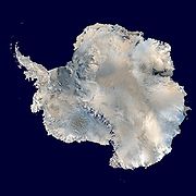
The Weddell Sea is part of the Southern Ocean
Southern Ocean
The Southern Ocean comprises the southernmost waters of the World Ocean, generally taken to be south of 60°S latitude and encircling Antarctica. It is usually regarded as the fourth-largest of the five principal oceanic divisions...
and contains the Weddell Gyre
Weddell Gyre
Antarctic gyre may refer to any of the three ocean currents and gyres within the Southern Ocean:* Antarctic Circumpolar Current, an ocean current circulating around Antarctica* Ross Gyre, an oceanic gyre in the Ross Sea...
. Its land boundaries are defined by the bay formed from the coasts of Coats Land
Coats Land
Coats Land is a region in Antarctica which lies westward of Queen Maud Land and forms the eastern shore of the Weddell Sea, extending in a general northeast-southwest direction between 20º00´W and 36º00´W. The northeast part was discovered from the Scotia by William S. Bruce, leader of the Scottish...
and the Antarctic Peninsula
Antarctic Peninsula
The Antarctic Peninsula is the northernmost part of the mainland of Antarctica. It extends from a line between Cape Adams and a point on the mainland south of Eklund Islands....
. The easternmost point is Cape Norvegia
Cape Norvegia
Cape Norvegia is a prominent cape on Princess Martha Coast of Queen Maud Land. It marks the northeast extremity of Riiser-Larsen Ice Shelf in East Antarctica, and the border point of Weddell Sea and King Haakon VII Sea.. It was discovered by Commander Hjalmar Riiser-Larsen in February 1930 while on...
at Princess Martha Coast
Princess Martha Coast
Princess Martha Coast is that portion of the coast of Queen Maud Land lying between 05° E and the terminus of Stancomb-Wills Glacier, at 20° W. The entire coastline is bounded by ice shelves with ice cliffs 20 to 35 m high....
, Queen Maud Land
Queen Maud Land
Queen Maud Land is a c. 2.7 million-square-kilometre region of Antarctica claimed as a dependent territory by Norway. The territory lies between 20° west and 45° east, between the British Antarctic Territory to the west and the Australian Antarctic Territory to the east. The latitudinal...
. To the east of Cape Norvegia is the King Haakon VII Sea
King Haakon VII Sea
King Haakon VII Sea is an arm of the Southern Ocean on the coast of East Antarctica.-Geography:From the international point of view, King Haakon VII Sea lies between Weddell Sea and Lazarev Sea, and thus stretches only along Kronprinsesse Märtha Kyst from Cape Norvegia at 12°18'W, the easternmost...
. Much of the southern part of the sea, up to Elephant Island, is permanent ice, the Filchner-Ronne Ice Shelf
Filchner-Ronne Ice Shelf
The Filchner-Ronne Ice Shelf, also known as Ronne-Filchner Ice Shelf, is an Antarctic ice shelf bordering the Weddell Sea.-Description:...
. The sea is contained within the two overlapping Antarctic
Antarctic
The Antarctic is the region around the Earth's South Pole, opposite the Arctic region around the North Pole. The Antarctic comprises the continent of Antarctica and the ice shelves, waters and island territories in the Southern Ocean situated south of the Antarctic Convergence...
territorial claims of Argentina
Argentina
Argentina , officially the Argentine Republic , is the second largest country in South America by land area, after Brazil. It is constituted as a federation of 23 provinces and an autonomous city, Buenos Aires...
, (Argentine Antarctica
Argentine Antarctica
Argentine Antarctica is a sector of Antarctica claimed by Argentina as part of its national territory. The Argentine Antarctic region, consisting of the Antarctic Peninsula and a triangular section extending to the South Pole, is delimited by the 25° West and 74° West meridians and the 60° South...
) and Britain (British Antarctic Territory
British Antarctic Territory
The British Antarctic Territory is a sector of Antarctica claimed by the United Kingdom as one of its 14 British Overseas Territories. It comprises the region south of 60°S latitude and between longitudes and , forming a wedge shape that extends to the South Pole...
), and also resides partially within the territorial claim of Chile
Chile
Chile ,officially the Republic of Chile , is a country in South America occupying a long, narrow coastal strip between the Andes mountains to the east and the Pacific Ocean to the west. It borders Peru to the north, Bolivia to the northeast, Argentina to the east, and the Drake Passage in the far...
(Antarctic Chilean Territory
Antártica Chilena Province
Antártica Chilena Province is the southernmost and one of four provinces in Chile's southernmost region, Magallanes and Antártica Chilena Region . The capital is Puerto Williams...
). At its widest the sea is around 2,000 km across, in area it is around 2.8 million km².
In his 1950 book The White Continent, historian Thomas R. Henry writes, "The Weddell Sea is, according to the testimony of all who have sailed through its berg-filled waters, the most treacherous and dismal region on earth
Earth
Earth is the third planet from the Sun, and the densest and fifth-largest of the eight planets in the Solar System. It is also the largest of the Solar System's four terrestrial planets...
. The Ross Sea
Ross Sea
The Ross Sea is a deep bay of the Southern Ocean in Antarctica between Victoria Land and Marie Byrd Land.-Description:The Ross Sea was discovered by James Ross in 1841. In the west of the Ross Sea is Ross Island with the Mt. Erebus volcano, in the east Roosevelt Island. The southern part is covered...
is the relatively peaceful, predictable, and safe." He continues on for an entire chapter, relating myths of the green-haired merman
Merman
Mermen are mythical male equivalents of mermaids – legendary creatures who have the form of a human from the waist up and are fish-like from the waist down.-Mythology:...
sighted in the sea's icy waters, the inability of crews to navigate a path to the coast until 1949, and treacherous "flash freezes" that left ships, such as Ernest Shackleton
Ernest Shackleton
Sir Ernest Henry Shackleton, CVO, OBE was a notable explorer from County Kildare, Ireland, who was one of the principal figures of the period known as the Heroic Age of Antarctic Exploration...
's Endurance
Endurance (1912 ship)
The Endurance was the three-masted barquentine in which Sir Ernest Shackleton sailed for the Antarctic on the 1914 Imperial Trans-Antarctic Expedition...
, at the mercy of the ice floes.
The sea is named after the British sailor James Weddell
James Weddell
James Weddell was a British sailor, navigator and seal hunter who in the early Spring of 1823 sailed to latitude of 74°15' S and into a region of the Southern Ocean that later became known as the Weddell Sea.-Early life:He entered the merchant service very...
who entered the sea in 1823 as far as 74°S
74th parallel south
The 74th parallel south is a circle of latitude that is 74 degrees south of the Earth's equatorial plane in the Antarctic. The parallel passes through the Southern Ocean and Antarctica....
. That same year the American sealing captain Benjamin Morrell claimed to have seen land some 10–12° east of the sea's actual eastern boundary. He called this New South Greenland
New South Greenland
New South Greenland, sometimes known as Morrell's Land, was an appearance of land recorded by the American captain Benjamin Morrell of the schooner Wasp in , during a sealing and exploration voyage in the Weddell Sea area of Antarctica. Morrell provided precise coordinates and a description of a...
, but its existence was disproved when the sea was more fully explored in the early 20th century. The furthest southern penetration since Weddell but before the modern era was made by the Scot
Scotland
Scotland is a country that is part of the United Kingdom. Occupying the northern third of the island of Great Britain, it shares a border with England to the south and is bounded by the North Sea to the east, the Atlantic Ocean to the north and west, and the North Channel and Irish Sea to the...
William Speirs Bruce
William Speirs Bruce
William Speirs Bruce was a London-born Scottish naturalist, polar scientist and oceanographer who organised and led the Scottish National Antarctic Expedition to the South Orkney Islands and the Weddell Sea. Among other achievements, the expedition established the first permanent weather station...
in 1903.
Various ice shelves, including the Filchner-Ronne Ice Shelf
Filchner-Ronne Ice Shelf
The Filchner-Ronne Ice Shelf, also known as Ronne-Filchner Ice Shelf, is an Antarctic ice shelf bordering the Weddell Sea.-Description:...
, fringe the Weddell sea. Some of the ice shelves on the east side of the Antarctic Peninsula
Antarctic Peninsula
The Antarctic Peninsula is the northernmost part of the mainland of Antarctica. It extends from a line between Cape Adams and a point on the mainland south of Eklund Islands....
, which used to extend roughly 3900 square miles (10,000 km²) over the Weddell Sea, had completely disappeared by 2002; see Retreat of glaciers since 1850#Antarctica. Whilst a dramatic event, the area that disappeared was far smaller than the total area of ice shelf that remains.
Characteristic fauna of the sea include the Weddell Seal
Weddell Seal
The Weddell seal , is a relatively large and abundant true seal with a circumpolar distribution surrounding Antarctica. Weddell seals have the most southerly distribution of any mammal, with a habitat that extends as far south as McMurdo Sound...
.
The Weddell Sea has been deemed by scientists to have the clearest water of any sea. Dutch researchers from the German Alfred Wegener Institute, on finding a Secchi disc visible at a depth of 262 feet on October 13, 1986, ascertained that the clarity corresponded to that of distilled water.
The Weddell Sea is an important area of deep water mass formation through cabbeling
Cabbeling
Cabbeling is the resultant sinking of a combined water parcel due to the mixing process of two separate water parcels. Sinking occurs because of the higher density of the combined water parcel from the mixing of two water parcels of the same density, but different salinity and temperature...
, the main driving force of the thermohaline circulation. Deep water masses are also formed through cabbeling in the North Atlantic and are caused by differences in temperature and salinity of the water. In the Weddell sea this is brought about mainly by brine exclusion and wind cooling.
External links
- Foraminifera of the Weddell Sea bottom – Deep Sea Foraminifera from 4400m depth - an image gallery of hundreds of specimens and description