
Neighborhoods of Richmond, Virginia
Encyclopedia
This article is about the various neighborhoods and districts in the Greater Richmond, Virginia
area. Note that this article is an attempt to be inclusive of the broader definitions of the areas which are often considered part of Metropolitan Richmond, based on their urban or suburban character and nature (as identified by architectural historians, urban planners, or the like), rather than by strictly political boundaries.
 The Greater Richmond
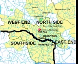
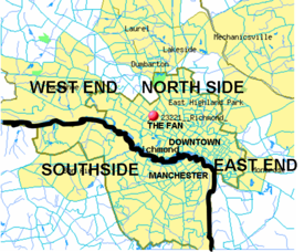
area extends beyond the city limits into nearby counties. Descriptions of Richmond often describe the large area as falling into one of the four primarily geographic references which somewhat mirror the points of a compass: North Side
, Southside
, East End
and West End
. Since there is no one municipal organization that represents the Greater Richmond region, the boundaries of these subregions are loosely defined. The definitions are also affected by the James River
which has separated Henrico County
on the north bank and Chesterfield County
to the south since the latter was formed in the 18th century. Until 1910, the James also separated the City of Richmond on the north bank from the City of Manchester
on the south bank, until they merged by mutual agreement in 1910. A large portion of the river which divides the modern City of Richmond is part of the city's James River Park System.
Except where the James River continues to define a boundary between the West End and Southside, drawing a theoretical line between quadrants of the metropolitan area is not well defined as one moves away from the city. This is especially true north of the James with the distinctions between East, North, and West end areas, all of which are north of the River. In the broadest context, each of these may be considered by some to include portions of Hanover County
, which at its closest point, is only 5 miles from the current city limits. However, the Chickahominy River
separates the Hanover from Henrico County at this closest point, which is in the Mechanicsville
area. Some outlying areas meeting may be considered as independent or outside the Richmond area, such as Mechanicsville, Midlothian, or Short Pump.
is an historically black neighborhood that at one time was known as the "Harlem of the South. " A center for black commerce
and entertainment
, it was frequented by the likes of Duke Ellington
, Ella Fitzgerald
, Bill "Bojangles" Robinson, Lena Horne
, Cab Calloway
, Billie Holiday
, Nat King Cole
and James Brown. Jackson Ward was also home to Maggie L. Walker
, the first woman to charter and serve as president of an American bank. The Maggie L. Walker House is now a U.S. National Historic Site. Jackson Ward is home to the Hippodrome Theater.
During the construction of the Eisenhower
Interstate highway system in the 1950s Jackson Ward was split in two, much to the detriment of the neighborhood. In the early 2000s, the Greater Richmond Convention Center and Visitors Bureau was built at the eastern edge of Jackson Ward.
walk project, a refurbishment of a 1.25-mile segment of the Haxall Canal and the James River & Kanawha Canal
that had fallen into disuse. Developed as a tourist destination, the area surrounding the Canal Walk was brand
ed by The River District Alliance (RDA) (a 501(c)6 public/private organization) as "The River District." http://www.richmondriverdistrict.com/.
The actual boundaries of the River district are not defined, and include some businesses commonly thought to belong to other district
s, like Shockoe Bottom and Shockoe Slip. http://www.richmond.com/riverdistrict/clientoutput.cfm?id=3280073
Similar Canal Walks were built in San Antonio, Texas
, and Indianapolis, Indiana
.
became popular across the United States. The rough boundaries of Shockoe Slip include 14th Street, Main Street, Canal Street and 12th Street.
and east/northeast of the former Virginia Central Railroad
- Chesapeake and Ohio Railway
line (now owned by CSX Transportation
and operated by the Buckingham Branch Railroad
) which originated at Main Street Station
, and south and west of I-295
.
Within the city, this includes neighborhoods such as Church Hill
, Fairmount
, Union Hill, Fulton, Fulton Hill
, Montrose Heights, Fairfield Court, Creighton Court, Whitcomb Court, Mosby Court, Eastview, Brauers, Peter Paul, Woodville, North Church Hill, Chimborazo and Oakwood.
The terminology "East End" also broadly includes much of eastern Henrico County
and part of Hanover County
as a portion the Richmond Metropolitan area.
gave his "Give me liberty or give me death" speech in St. John's Church
. Chimborazo Park
occupies the former site of the largest American Civil War
Hospital. Church Hill is notable as one of the largest extant 19th century neighborhoods in America, with many fine examples of period architecture. This area has undergone significant gentrification
in recent years.
baseball stadium from its current location at The Diamond to Shockoe Bottom or Tobacco Row
, These plans fell through and in 2009 the Richmond Braves
moved to Gwinnett, GA.
near its eastern terminus at the head of navigation of the James River
. Beginning in the 18th century, many growers and shippers of Virginia's major cash-crop of tobacco
maintained facilities there, as well as directly across the river at Manchester
. Substantial multi-story brick buildings were constructed to protect the contents from loss due to fire.
During the American Civil War
(1861–1865), Tobacco Row was the site of infamous Libby Prison
and nearby Castle Thunder
, detention facilities of the Confederate
government.
The area was vacated by the tobacco companies by the late 1980s. Led by Richmond developer William H. Abeloff, many of the old warehouses of Tobacco Row were modernized and converted into developments of loft apartments, condominiums, offices, and retail space along part of the restored canal system.
. Houses of a remarkable mix are balanced along the irregular, picturesque and sometimes narrow streets that follow the curve of the hill. Those homes that line Jefferson Park have a clear view of downtown Richmond. Union Hill is bordered on the south by Jefferson Avenue, on the north by Venable Street, on the east by 25th Street, and by Mosby on the west. The term “Union Hill” first occurs in 1817 — probably referring to the combination of several hills that were joined by fill and grading over the years.
Union Hill will be featured in November 2007 on The Learning Channel's television program "Flip It Back." The episode will highlight the opportunities for historic preservation and investment in the neighborhood while focusing on the efforts by local entrepreneurs to restore and market a turn-of-the-century double house located at 816 and 818 North 23rd Street.
and Maymont Park
, on the north by the Downtown Expressway, on the east by Meadow Street. The heart of the neighborhood is located north and east of its namesake and its three lakes; Boat, Swan and Shields. Homes include row houses built in the 1920s, two-story frame bungalows, brick Colonials, Cape Cods, tri-levels, ranchers and American Four Squares mostly built in the 1930s and 1940s. Westover Road hosts a number of large lakefront Spanish, Georgian and Colonial Revival mansions. The Fountain Lake area features upscale condos and apartments. A small, neighborhood retail section and a converted 1922 public school (now retirement home) is located along middle blocks Idlewood Avenue in the northern part of the neighborhood.
For more information see the Byrd Park Civic League website http://www.byrdpark.org or the Byrd Park community blog http://byrdpark.net.
to the west of Jackson Ward and downtown Richmond. Carver was first settled by blue-collar Jewish and German
tradesmen, and became a thriving black community in the early 1900s before being cut through by major thoroughfares such as Jefferson Davis Highway
, Belvidere Street and Interstate 95
. As the years passed, more and more houses became vacant, and the neighborhood declined. By the 1950s, Carver began to sharply decline and was seen as a "dangerous" neighborhood.
In modern times, Carver has seen new life, with redevelopment of older housing, some new homes, expansion to the north side of Broad Street of Virginia Commonwealth University
facilities and student housing. Today, Carver is a diverse mix of students, singles, young families, and elderly residents.
, located in this district, is a historic 1920s era movie palace
that shows second run movies and that offers periodic performances of its Wurlitzer
organ.
The Museum District (also known as West of the Boulevard) is located just west of the Fan district (and the Boulevard) and north of Carytown. Historically, this area was a site where many Confederate Soldiers were hospitalized/lived after the American Civil War
. Some large institutions in this district are the Virginia Museum of Fine Arts
, the world headquarters for the United Daughters of the Confederacy
, and the Virginia Historical Society
.
in 2001.
. Randolph is notable for its access to the historic and scenic areas of Maymont Park
, North Bank Park, and Hollywood Cemetery. The neighborhood is home to many blue-collar families.
, Bellevue, Ginter Park
, Rosedale, Washington Park, Hermitage Rd, Highland Park
, Sherwood Park, etc. These neighborhoods are made up of houses with a variety of architectural styles, which include Arts and Crafts Bungalows, Victorian, Romanesque Revival, and Queen Anne houses among other styles. The city's North Side also includes the campuses of several schools of higher education, Virginia Union University
and Union Theological Seminary
.
The terminology "North Side" also broadly includes much of central Henrico County
and even some portions of Hanover County
as a portion of the Richmond Metropolitan area.
, Manchester (also known as Old Manchester and South Richmond) has a distinguished history of its own.
Originally known as Rocky Ridge, for over 200 years, Manchester
was a separate town and later independent city
on the south bank of the James River across from Richmond. It was commercially successful due to its agricultural mills and docks, where coal
from the Midlothian area 13 miles west was transported on the Chesterfield Railroad
, the first in Virginia, beginning in 1831. The City of Manchester merged with Richmond in 1910.
In current times, the Manchester section of Richmond is mostly notable for its new development. With many new homes and recent commercial additions such as Overnight Transportation, Legend Brewery, refurbished industrial building loft condominiums, Sun Trust's Riverview Center, and the Plant Zero Cafe Art Works Studios and Galleries, and Plant Zero Event Space, it is seen as an area of rapid growth. Currently, these efforts of revitalization are moving the buzz word of the area, now known to locals as "Old Manchester." Efforts from the city, developers, merchants, and local artists, and community members, are now maintaining an improved lifestyle.
The former Southern Railway
passenger station in Manchester now houses the Old Dominion Railway Historical Society's museum at 2nd and Hull Streets, near the south end of the Mayo Bridge.
(also known as the "Nickel Bridge", its original toll) from the City’s Fan District. The neighborhood lies along both the east and west sides of Westover Hills Boulevard in that area. This location makes it near the geographical center of the City. Most of the homes were built during the 1920-1940 period. The styles are highly varied, with Cape Cods located next to Spanish Colonial and Tudor Revival, with the odd farmhouse or Arts and Crafts thrown in. Many of the houses were first built to be near the terminus of the trolley line which ran up Semmes Avenue and terminated at Forest Hill Park
, where an amusement park and swimming lakes were located.
Many housing sites feature large lots and a generally suburban feel. Some homes are located overlooking the banks of the James River, Westover Hills Boulevard, Forest Hill Ave. and Forest Hill Park. The neighborhood features well-established restaurants and businesses, along with churches and some arts establishments.
The neighborhood was also home to Frederick William Sievers
, sculptor of the Matthew Fontaine Maury
and Stonewall Jackson
monuments on Monument Avenue
as well as the Virginia Monument at Gettysburg, Pennsylvania
. There is a historical marker at the location of his workshop in the yard of a West 43rd Street home.
For more information see the Westover Hills Neighborhood Association website Westover-Hills.org
Richmond, Virginia
Richmond is the capital of the Commonwealth of Virginia, in the United States. It is an independent city and not part of any county. Richmond is the center of the Richmond Metropolitan Statistical Area and the Greater Richmond area...
area. Note that this article is an attempt to be inclusive of the broader definitions of the areas which are often considered part of Metropolitan Richmond, based on their urban or suburban character and nature (as identified by architectural historians, urban planners, or the like), rather than by strictly political boundaries.
Description of the Richmond Metro Region from a Quadrant Perspective
Richmond, Virginia
Richmond is the capital of the Commonwealth of Virginia, in the United States. It is an independent city and not part of any county. Richmond is the center of the Richmond Metropolitan Statistical Area and the Greater Richmond area...
area extends beyond the city limits into nearby counties. Descriptions of Richmond often describe the large area as falling into one of the four primarily geographic references which somewhat mirror the points of a compass: North Side
North Side (Richmond Virginia)
The North Side is an area composed of northern Richmond, Virginia and some parts of Henrico County, Virginia.The area is home to many diverse neighborhoods, especially early streetcar suburbs, including Barton Heights, Bellevue, Ginter Park, Washington Park, Hermitage Road, Highland Park, Sherwood...
, Southside
Southside (Richmond, Virginia)
The Southside of Richmond is an area of the Metropolitan Statistical Area surrounding Richmond, Virginia. It generally includes all portions of the City of Richmond which lie south of the James River, and includes all of the former city of Manchester...
, East End
East End (Richmond, Virginia)
The East End of Richmond, Virginia is the quadrant of the City of Richmond, Virginia, and more loosely the Richmond metropolitan area, east of the downtown.-Geographic boundaries:...
and West End
The West End (Richmond, Virginia)
The West End is a part of Richmond, Virginia. The true West End covers only the western part of the city of Richmond though some consider western Henrico County part of the West End as well. As there is no one municipal organization that represents this specific region, the boundaries are loosely...
. Since there is no one municipal organization that represents the Greater Richmond region, the boundaries of these subregions are loosely defined. The definitions are also affected by the James River
James River (Virginia)
The James River is a river in the U.S. state of Virginia. It is long, extending to if one includes the Jackson River, the longer of its two source tributaries. The James River drains a catchment comprising . The watershed includes about 4% open water and an area with a population of 2.5 million...
which has separated Henrico County
Henrico County, Virginia
Henrico is a county located in the Commonwealth of Virginia, a state of the United States. As of 2010, Henrico was home to 306,935 people. It is located in the Richmond-Petersburg region and is a portion of the Richmond Metropolitan Statistical Area...
on the north bank and Chesterfield County
Chesterfield County, Virginia
Chesterfield County is a county located in the Commonwealth of Virginia, a state of the United States. In 2010, its population was estimated to be 316,236. Chesterfield County is now the fourth-largest municipality in Virginia . Its county seat is Chesterfield...
to the south since the latter was formed in the 18th century. Until 1910, the James also separated the City of Richmond on the north bank from the City of Manchester
Manchester, Virginia
Manchester, Virginia is a former independent city in Virginia in the United States. Prior to receiving independent status, it served as the county seat of Chesterfield County, between 1870 and 1876...
on the south bank, until they merged by mutual agreement in 1910. A large portion of the river which divides the modern City of Richmond is part of the city's James River Park System.
Except where the James River continues to define a boundary between the West End and Southside, drawing a theoretical line between quadrants of the metropolitan area is not well defined as one moves away from the city. This is especially true north of the James with the distinctions between East, North, and West end areas, all of which are north of the River. In the broadest context, each of these may be considered by some to include portions of Hanover County
Hanover County, Virginia
As of the census of 2000, there were 86,320 people, 31,121 households, and 24,461 families residing in the county. The population density was 183 people per square mile . There were 32,196 housing units at an average density of 68 per square mile...
, which at its closest point, is only 5 miles from the current city limits. However, the Chickahominy River
Chickahominy River
The Chickahominy is an river in the eastern portion of the U.S. state of Virginia. The river rises about northwest of Richmond and flows southeast and south to the James River...
separates the Hanover from Henrico County at this closest point, which is in the Mechanicsville
Mechanicsville, Virginia
Mechanicsville is the name of four places in the Commonwealth of Virginia in the United States of America:*Mechanicsville, Hanover County, Virginia*Mechanicsville, Loudoun County, Virginia*Mechanicsville, Rockbridge County, Virginia...
area. Some outlying areas meeting may be considered as independent or outside the Richmond area, such as Mechanicsville, Midlothian, or Short Pump.
Downtown
Jackson Ward
Jackson WardJackson Ward
Jackson Ward is a historically African-American neighborhood in Richmond, Virginia, USA. It is located less than a mile from the Virginia State Capitol...
is an historically black neighborhood that at one time was known as the "Harlem of the South. " A center for black commerce
Commerce
While business refers to the value-creating activities of an organization for profit, commerce means the whole system of an economy that constitutes an environment for business. The system includes legal, economic, political, social, cultural, and technological systems that are in operation in any...
and entertainment
Entertainment
Entertainment consists of any activity which provides a diversion or permits people to amuse themselves in their leisure time. Entertainment is generally passive, such as watching opera or a movie. Active forms of amusement, such as sports, are more often considered to be recreation...
, it was frequented by the likes of Duke Ellington
Duke Ellington
Edward Kennedy "Duke" Ellington was an American composer, pianist, and big band leader. Ellington wrote over 1,000 compositions...
, Ella Fitzgerald
Ella Fitzgerald
Ella Jane Fitzgerald , also known as the "First Lady of Song" and "Lady Ella," was an American jazz and song vocalist...
, Bill "Bojangles" Robinson, Lena Horne
Lena Horne
Lena Mary Calhoun Horne was an American singer, actress, civil rights activist and dancer.Horne joined the chorus of the Cotton Club at the age of sixteen and became a nightclub performer before moving to Hollywood, where she had small parts in numerous movies, and more substantial parts in the...
, Cab Calloway
Cab Calloway
Cabell "Cab" Calloway III was an American jazz singer and bandleader. He was strongly associated with the Cotton Club in Harlem, New York City where he was a regular performer....
, Billie Holiday
Billie Holiday
Billie Holiday was an American jazz singer and songwriter. Nicknamed "Lady Day" by her friend and musical partner Lester Young, Holiday had a seminal influence on jazz and pop singing...
, Nat King Cole
Nat King Cole
Nathaniel Adams Coles , known professionally as Nat King Cole, was an American musician who first came to prominence as a leading jazz pianist. Although an accomplished pianist, he owes most of his popular musical fame to his soft baritone voice, which he used to perform in big band and jazz genres...
and James Brown. Jackson Ward was also home to Maggie L. Walker
Maggie L. Walker
Maggie Lena Walker was an African American teacher and businesswoman. Walker was the first African American female bank president and the first woman to charter a bank in the United States. As a leader, she achieved successes with the vision to make tangible improvements in the way of life for...
, the first woman to charter and serve as president of an American bank. The Maggie L. Walker House is now a U.S. National Historic Site. Jackson Ward is home to the Hippodrome Theater.
During the construction of the Eisenhower
Dwight D. Eisenhower
Dwight David "Ike" Eisenhower was the 34th President of the United States, from 1953 until 1961. He was a five-star general in the United States Army...
Interstate highway system in the 1950s Jackson Ward was split in two, much to the detriment of the neighborhood. In the early 2000s, the Greater Richmond Convention Center and Visitors Bureau was built at the eastern edge of Jackson Ward.
The River District
In 1999, the City of Richmond completed its canalCanal
Canals are man-made channels for water. There are two types of canal:#Waterways: navigable transportation canals used for carrying ships and boats shipping goods and conveying people, further subdivided into two kinds:...
walk project, a refurbishment of a 1.25-mile segment of the Haxall Canal and the James River & Kanawha Canal
James River and Kanawha Canal
The James River and Kanawha Canal was a canal in Virginia, which was built to facilitate shipments of passengers and freight by water between the western counties of Virginia and the coast....
that had fallen into disuse. Developed as a tourist destination, the area surrounding the Canal Walk was brand
Brand
The American Marketing Association defines a brand as a "Name, term, design, symbol, or any other feature that identifies one seller's good or service as distinct from those of other sellers."...
ed by The River District Alliance (RDA) (a 501(c)6 public/private organization) as "The River District." http://www.richmondriverdistrict.com/.
The actual boundaries of the River district are not defined, and include some businesses commonly thought to belong to other district
District
Districts are a type of administrative division, in some countries managed by a local government. They vary greatly in size, spanning entire regions or counties, several municipalities, or subdivisions of municipalities.-Austria:...
s, like Shockoe Bottom and Shockoe Slip. http://www.richmond.com/riverdistrict/clientoutput.cfm?id=3280073
Similar Canal Walks were built in San Antonio, Texas
San Antonio, Texas
San Antonio is the seventh-largest city in the United States of America and the second-largest city within the state of Texas, with a population of 1.33 million. Located in the American Southwest and the south–central part of Texas, the city serves as the seat of Bexar County. In 2011,...
, and Indianapolis, Indiana
Indianapolis, Indiana
Indianapolis is the capital of the U.S. state of Indiana, and the county seat of Marion County, Indiana. As of the 2010 United States Census, the city's population is 839,489. It is by far Indiana's largest city and, as of the 2010 U.S...
.
Shockoe Slip
Shockoe Slip is a collection of tobacco warehouses in which are located shops, restaurants, and offices. The name "slip" refers to the canal boat slips nearby where goods were loaded and unloaded. Shockoe Slip became developed as a commercial and entertainment district in the 1970s. The nightlife district came just after Richmond passed liquor-by-the-drink laws, and when the so-called fern barFern bar
Fern bar is an American slang term for an upscale or preppy bar or tavern catering to singles usually decorated with ferns or other "fussy" plants, as well as such decor as fake Tiffany lamps...
became popular across the United States. The rough boundaries of Shockoe Slip include 14th Street, Main Street, Canal Street and 12th Street.
East End
The East End of Richmond, Virginia is actually a collection of neighborhoods. Within the city, and in Henrico County, it roughly defined as including the area of Richmond north of the James RiverJames River (Virginia)
The James River is a river in the U.S. state of Virginia. It is long, extending to if one includes the Jackson River, the longer of its two source tributaries. The James River drains a catchment comprising . The watershed includes about 4% open water and an area with a population of 2.5 million...
and east/northeast of the former Virginia Central Railroad
Virginia Central Railroad
Virginia Central Railroad was chartered as the Louisa Railroad in 1836 by the Virginia Board of Public Works and had its name changed to Virginia Central Railroad in 1850. It connected Richmond with the Orange and Alexandria Railroad at Gordonsville in 1854, and had expanded westward past the Blue...
- Chesapeake and Ohio Railway
Chesapeake and Ohio Railway
The Chesapeake and Ohio Railway was a Class I railroad formed in 1869 in Virginia from several smaller Virginia railroads begun in the 19th century. Led by industrialist Collis P...
line (now owned by CSX Transportation
CSX Transportation
CSX Transportation operates a Class I railroad in the United States known as the CSX Railroad. It is the main subsidiary of the CSX Corporation. The company is headquartered in Jacksonville, Florida, and owns approximately 21,000 route miles...
and operated by the Buckingham Branch Railroad
Buckingham Branch Railroad
Buckingham Branch Railroad is a Class III short-line railroad operating over 200 miles of historic and strategic trackage in Central Virginia...
) which originated at Main Street Station
Main Street Station (Richmond)
Richmond Main Street Station is a historic railroad station and office building in Richmond, Virginia. Originally built in 1901, it is currently served by Amtrak, and is planned in the future to become the northern terminus of the Southeast High Speed Rail Corridor as well as an intermodal station...
, and south and west of I-295
Interstate 295 (Virginia)
Interstate 295 is an eastern and northern bypass of the cities of Richmond and Petersburg in the U.S. state of Virginia. The southern terminus is a junction with Interstate 95 southeast of Petersburg...
.
Within the city, this includes neighborhoods such as Church Hill
Church Hill
Church Hill, also known as the St. John's Church Historic District, is an Old and Historic District in Richmond, Virginia. This district encompasses the original land plat of the city of Richmond. Church Hill is the eastern terminus of Broad Street, a major east-west thoroughfare in the Richmond...
, Fairmount
Fairmount, Richmond
Originally a trolley car suburb in the years just before the dawn of the 20th century, the Fairmount neighborhood in Church Hill, Richmond, Virginia, is located just north of Union Hill. Much of the neighborhood was developed from the 1890s to the 1920s, and its buildings largely reflect Queen...
, Union Hill, Fulton, Fulton Hill
Fulton Hill
Fulton Hill is a neighborhood located in the East End of Richmond, Virginia. The name is used for the area stretching from Gillies Creek to the Richmond city limits, often including Fulton Bottom and Montrose Heights. The zip code is 23231.-History:...
, Montrose Heights, Fairfield Court, Creighton Court, Whitcomb Court, Mosby Court, Eastview, Brauers, Peter Paul, Woodville, North Church Hill, Chimborazo and Oakwood.
The terminology "East End" also broadly includes much of eastern Henrico County
Henrico County, Virginia
Henrico is a county located in the Commonwealth of Virginia, a state of the United States. As of 2010, Henrico was home to 306,935 people. It is located in the Richmond-Petersburg region and is a portion of the Richmond Metropolitan Statistical Area...
and part of Hanover County
Hanover County, Virginia
As of the census of 2000, there were 86,320 people, 31,121 households, and 24,461 families residing in the county. The population density was 183 people per square mile . There were 32,196 housing units at an average density of 68 per square mile...
as a portion the Richmond Metropolitan area.
Church Hill
The historic district of Church Hill encompasses the original land plot of the city of Richmond. There Patrick HenryPatrick Henry
Patrick Henry was an orator and politician who led the movement for independence in Virginia in the 1770s. A Founding Father, he served as the first and sixth post-colonial Governor of Virginia from 1776 to 1779 and subsequently, from 1784 to 1786...
gave his "Give me liberty or give me death" speech in St. John's Church
Saint John's Church, Richmond, Virginia
St. John's is an Episcopal church located at 2401 East Broad Street in Richmond, Virginia. Formed from several earlier churches, St. John's is the oldest church in Richmond, built by Col. Richard Randolph in 1741 and giving its name to the Church Hill district...
. Chimborazo Park
Chimborazo Park
Chimborazo Park is a park and historic land site in Richmond, Virginia, United States. Created in 1874, the park was the site of Chimborazo Hospital, one of the world's largest military hospitals.-Chimborazo Hospital:...
occupies the former site of the largest American Civil War
American Civil War
The American Civil War was a civil war fought in the United States of America. In response to the election of Abraham Lincoln as President of the United States, 11 southern slave states declared their secession from the United States and formed the Confederate States of America ; the other 25...
Hospital. Church Hill is notable as one of the largest extant 19th century neighborhoods in America, with many fine examples of period architecture. This area has undergone significant gentrification
Gentrification
Gentrification and urban gentrification refer to the changes that result when wealthier people acquire or rent property in low income and working class communities. Urban gentrification is associated with movement. Consequent to gentrification, the average income increases and average family size...
in recent years.
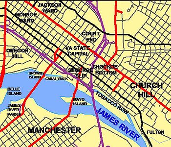
Shockoe Bottom
Shockoe Bottom, just east of downtown along the James River, became a major nightlife, dining, and entertainment center in the last two decades of the 20th century. After centuries of periodic flooding by the James River, development was greatly stimulated by the completion of Richmond's James River Flood Wall in 1995. Ironically, the next flooding disaster came not from the river, but from Hurricane Gaston which brought extensive local tributary flooding along the basin of Shockoe Creek and did extensive damage to this area in 2004, with businesses being shut down and many buildings condemned. The city of Richmond had serious discussions about moving the Richmond BravesRichmond Braves
The Richmond Braves were the Triple-A affiliate of the Atlanta Braves and played in the International League. Colloquially referred to as the R-Braves, they were based in Richmond, Virginia, where they played from 1966, when the Milwaukee Braves moved to Atlanta where their AAA team, the Crackers,...
baseball stadium from its current location at The Diamond to Shockoe Bottom or Tobacco Row
Tobacco Row
Tobacco Row is a collection of tobacco warehouses and cigarette factories in Richmond, Virginia adjacent to the James River and Kanawha Canal near its eastern terminus at the head of navigation of the James River.-History:...
, These plans fell through and in 2009 the Richmond Braves
Richmond Braves
The Richmond Braves were the Triple-A affiliate of the Atlanta Braves and played in the International League. Colloquially referred to as the R-Braves, they were based in Richmond, Virginia, where they played from 1966, when the Milwaukee Braves moved to Atlanta where their AAA team, the Crackers,...
moved to Gwinnett, GA.
Tobacco Row
Just east of Shockoe Bottom, Tobacco Row is a collection of tobacco warehouses and cigarette factories adjacent to the James River and Kanawha CanalJames River and Kanawha Canal
The James River and Kanawha Canal was a canal in Virginia, which was built to facilitate shipments of passengers and freight by water between the western counties of Virginia and the coast....
near its eastern terminus at the head of navigation of the James River
James River (Virginia)
The James River is a river in the U.S. state of Virginia. It is long, extending to if one includes the Jackson River, the longer of its two source tributaries. The James River drains a catchment comprising . The watershed includes about 4% open water and an area with a population of 2.5 million...
. Beginning in the 18th century, many growers and shippers of Virginia's major cash-crop of tobacco
Tobacco
Tobacco is an agricultural product processed from the leaves of plants in the genus Nicotiana. It can be consumed, used as a pesticide and, in the form of nicotine tartrate, used in some medicines...
maintained facilities there, as well as directly across the river at Manchester
Manchester, Virginia
Manchester, Virginia is a former independent city in Virginia in the United States. Prior to receiving independent status, it served as the county seat of Chesterfield County, between 1870 and 1876...
. Substantial multi-story brick buildings were constructed to protect the contents from loss due to fire.
During the American Civil War
American Civil War
The American Civil War was a civil war fought in the United States of America. In response to the election of Abraham Lincoln as President of the United States, 11 southern slave states declared their secession from the United States and formed the Confederate States of America ; the other 25...
(1861–1865), Tobacco Row was the site of infamous Libby Prison
Libby Prison
Libby Prison was a Confederate Prison at Richmond, Virginia, during the American Civil War. It gained an infamous reputation for the harsh conditions under which prisoners from the Union Army were kept.- Overview :...
and nearby Castle Thunder
Castle Thunder (prison)
Castle Thunder, located in Richmond, Virginia, was a former tobacco warehouse located on Tobacco Row, converted into a prison used by the Confederacy to house civilian prisoners, including captured Union spies, political prisoners and those charged with treason during the American Civil War. A...
, detention facilities of the Confederate
Confederate States of America
The Confederate States of America was a government set up from 1861 to 1865 by 11 Southern slave states of the United States of America that had declared their secession from the U.S...
government.
The area was vacated by the tobacco companies by the late 1980s. Led by Richmond developer William H. Abeloff, many of the old warehouses of Tobacco Row were modernized and converted into developments of loft apartments, condominiums, offices, and retail space along part of the restored canal system.
Union Hill
Union Hill is one of the oldest and most historically significant neighborhoods of Richmond and, as such, has been the recent focus of rapid gentrification and preservation. Its architectural and historical significance has earned the neighborhood designation on the National Register of Historic Places and the Virginia Landmarks Register. It is situated on the high western bluff above Shockoe BottomShockoe Bottom
Shockoe Bottom is an area in Richmond, Virginia, just east of downtown, along the James River. Located between Shockoe Hill and Church Hill, Shockoe Bottom contains much of the land included in Colonel William Mayo's 1737 plan of Richmond, making it one of the city's oldest...
. Houses of a remarkable mix are balanced along the irregular, picturesque and sometimes narrow streets that follow the curve of the hill. Those homes that line Jefferson Park have a clear view of downtown Richmond. Union Hill is bordered on the south by Jefferson Avenue, on the north by Venable Street, on the east by 25th Street, and by Mosby on the west. The term “Union Hill” first occurs in 1817 — probably referring to the combination of several hills that were joined by fill and grading over the years.
Union Hill will be featured in November 2007 on The Learning Channel's television program "Flip It Back." The episode will highlight the opportunities for historic preservation and investment in the neighborhood while focusing on the efforts by local entrepreneurs to restore and market a turn-of-the-century double house located at 816 and 818 North 23rd Street.
Near West and West End
This section covers those neighborhoods that have at any point historically been considered part of the West End of Richmond.Byrd Park
The Byrd Park neighborhood was in the Far West End of the City when it was planned in the late 1910s. This is a residential area, now in the Central neighborhoods of the City, bounded on the south by Byrd ParkByrd Park
Byrd Park is a public park located in Richmond, Virginia, USA north of the James River and adjacent to Maymont. The park includes a mile-long trail with exercise stops, monuments, an amphitheatre, and three small lakes: Shields , Swan, and Boat Lake. Boat Lake has a lighted fountain at its center...
and Maymont Park
Maymont Park
Maymont is a 100 acre Victorian estate located at 2201 Shields Lake Drive, Richmond, Virginia. It contains Maymont Mansion, now a historic house museum, an arboretum, formal gardens, a carriage collection, native wildlife exhibits, a nature center, and petting zoo known as "The Maymont Children's...
, on the north by the Downtown Expressway, on the east by Meadow Street. The heart of the neighborhood is located north and east of its namesake and its three lakes; Boat, Swan and Shields. Homes include row houses built in the 1920s, two-story frame bungalows, brick Colonials, Cape Cods, tri-levels, ranchers and American Four Squares mostly built in the 1930s and 1940s. Westover Road hosts a number of large lakefront Spanish, Georgian and Colonial Revival mansions. The Fountain Lake area features upscale condos and apartments. A small, neighborhood retail section and a converted 1922 public school (now retirement home) is located along middle blocks Idlewood Avenue in the northern part of the neighborhood.
For more information see the Byrd Park Civic League website http://www.byrdpark.org or the Byrd Park community blog http://byrdpark.net.
Carver
The Carver neighborhood, also called Sheep Hill, lies north of Broad Street (Richmond, Virginia)Broad Street (Richmond, Virginia)
Broad Street is a 15-mile long road located in the independent city of Richmond, Virginia and adjacent Henrico County. Broad Street is significant to Richmond due to the many commercial establishments that have been built along it throughout Richmond's history...
to the west of Jackson Ward and downtown Richmond. Carver was first settled by blue-collar Jewish and German
Germany
Germany , officially the Federal Republic of Germany , is a federal parliamentary republic in Europe. The country consists of 16 states while the capital and largest city is Berlin. Germany covers an area of 357,021 km2 and has a largely temperate seasonal climate...
tradesmen, and became a thriving black community in the early 1900s before being cut through by major thoroughfares such as Jefferson Davis Highway
Jefferson Davis Highway
The Jefferson Davis Memorial Highway was a planned transcontinental highway in the United States in the 1910s and 1920s that began in Washington, D.C. and extended south and west to San Diego, California; it was named for Jefferson Davis, who, in addition to being the first and only President of...
, Belvidere Street and Interstate 95
Interstate 95 in Virginia
In the Commonwealth of Virginia, Interstate 95 runs through the state. It runs concurrently for with Interstate 64 in Richmond, and meets the northern terminus of Interstate 85 in Petersburg. Though Interstate 95 was originally planned to go straight through Washington, D.C., it was instead...
. As the years passed, more and more houses became vacant, and the neighborhood declined. By the 1950s, Carver began to sharply decline and was seen as a "dangerous" neighborhood.
In modern times, Carver has seen new life, with redevelopment of older housing, some new homes, expansion to the north side of Broad Street of Virginia Commonwealth University
Virginia Commonwealth University
Virginia Commonwealth University is a public university located in Richmond, Virginia. It comprises two campuses in the Downtown Richmond area, the product of a merger between the Richmond Professional Institute and the Medical College of Virginia in 1968...
facilities and student housing. Today, Carver is a diverse mix of students, singles, young families, and elderly residents.
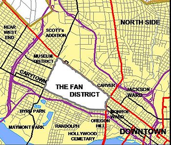
Carytown/Museum District
Carytown is a residential and commercial area that generally consists of 1920s era homes and privately owned shops, clothing stores, cafes, and restaurants along Cary Street. The Byrd TheatreByrd Theatre
The Byrd Theatre is a cinema in the Carytown neighborhood of Richmond, Virginia. It was named after William Byrd II, the founder of the city. The theater — the first in Virginia to be equipped with a sound system — opened on December 24, 1928 to much excitement and is affectionately referred to as...
, located in this district, is a historic 1920s era movie palace
Movie theater
A movie theater, cinema, movie house, picture theater, film theater is a venue, usually a building, for viewing motion pictures ....
that shows second run movies and that offers periodic performances of its Wurlitzer
Wurlitzer
The Rudolph Wurlitzer Company, usually referred to simply as Wurlitzer, was an American company that produced stringed instruments, woodwinds, brass instruments, theatre organs, band organs, orchestrions, electronic organs, electric pianos and jukeboxes....
organ.
The Museum District (also known as West of the Boulevard) is located just west of the Fan district (and the Boulevard) and north of Carytown. Historically, this area was a site where many Confederate Soldiers were hospitalized/lived after the American Civil War
American Civil War
The American Civil War was a civil war fought in the United States of America. In response to the election of Abraham Lincoln as President of the United States, 11 southern slave states declared their secession from the United States and formed the Confederate States of America ; the other 25...
. Some large institutions in this district are the Virginia Museum of Fine Arts
Virginia Museum of Fine Arts
The Virginia Museum of Fine arts, or VMFA, is an art museum in Richmond, Virginia, in the United States, which opened in 1936.The museum is owned and operated by the Commonwealth of Virginia, while private donations, endowments, and funds are used for the support of specific programs and all...
, the world headquarters for the United Daughters of the Confederacy
United Daughters of the Confederacy
The United Daughters of the Confederacy is a women's heritage association dedicated to honoring the memory of those who served in the military and died in service to the Confederate States of America . UDC began as the National Association of the Daughters of the Confederacy, organized in 1894 by...
, and the Virginia Historical Society
Virginia Historical Society
The Virginia Historical Society , founded in 1831 as the Virginia Historical and Philosophical Society and headquartered in Richmond, Virginia, is a major repository, research, and teaching center for Virginia history...
.
Newtowne West
Located west of Carver, Newtowne West is a residential neighborhood located north of Broad St. between Hermitage Rd. and Lombardy St., and south of Interstates 95 and 64. Newtowne West began as a working-class African American neighborhood in the 1890s but gradually became a more self-sufficient community in the 1920s before falling into disrepair during the second half of the twentieth century. Selected in 1999 as a part of Richmond City's Neighborhoods in Bloom program, Newtowne West is currently a center of revitalization including the renovation of the historic Maggie L. Walker High SchoolMaggie L. Walker Governor's School for Government and International Studies
The Maggie L. Walker Governor's School for Government and International Studies is a public regional magnet high school in Richmond, Virginia....
in 2001.
Randolph
This is a residential area bounded on the south by Colorado Avenue, on the north by the Downtown Expressway, on the east by several historic cemeteries and on the west by Meadow Street and Maymont ParkMaymont Park
Maymont is a 100 acre Victorian estate located at 2201 Shields Lake Drive, Richmond, Virginia. It contains Maymont Mansion, now a historic house museum, an arboretum, formal gardens, a carriage collection, native wildlife exhibits, a nature center, and petting zoo known as "The Maymont Children's...
. Randolph is notable for its access to the historic and scenic areas of Maymont Park
Maymont Park
Maymont is a 100 acre Victorian estate located at 2201 Shields Lake Drive, Richmond, Virginia. It contains Maymont Mansion, now a historic house museum, an arboretum, formal gardens, a carriage collection, native wildlife exhibits, a nature center, and petting zoo known as "The Maymont Children's...
, North Bank Park, and Hollywood Cemetery. The neighborhood is home to many blue-collar families.
North Side
Richmond's North Side is home to many diverse neighborhoods, including Barton HeightsBarton Heights
Barton Heights is a streetcar suburb neighborhood and former town in the Northside area of Richmond, Virginia. The area was primarily developed between 1890 and the 1920s.-History:...
, Bellevue, Ginter Park
Ginter Park
Ginter Park is a suburb neighborhood of Richmond, Virginia built on land owned and developed by Lewis Ginter. The neighborhood's first well known resident was newspaperman Joseph Bryan, who lived in Laburnum, first built in 1883 and later rebuilt . In 1895, many acres of land north of Richmond were...
, Rosedale, Washington Park, Hermitage Rd, Highland Park
Highland Park (Richmond)
Highland Park is a neighborhood located to the north of downtown Richmond, Virginia. Over time, various boundaries have served to split the neighborhood into sections traditionally labeled East Highland Park, North Highland Park, and South Highland Park...
, Sherwood Park, etc. These neighborhoods are made up of houses with a variety of architectural styles, which include Arts and Crafts Bungalows, Victorian, Romanesque Revival, and Queen Anne houses among other styles. The city's North Side also includes the campuses of several schools of higher education, Virginia Union University
Virginia Union University
Virginia Union University is a historically black university located in Richmond, Virginia, United States. It took its present name in 1899 upon the merger of two older schools, Richmond Theological Institute and Wayland Seminary, each founded after the end of American Civil War by the American...
and Union Theological Seminary
Union Theological Seminary & Presbyterian School of Christian Education
Union Presbyterian Seminary, located on the near north side of the city of Richmond, Virginia, is a theological seminary of the Presbyterian Church...
.
The terminology "North Side" also broadly includes much of central Henrico County
Henrico County, Virginia
Henrico is a county located in the Commonwealth of Virginia, a state of the United States. As of 2010, Henrico was home to 306,935 people. It is located in the Richmond-Petersburg region and is a portion of the Richmond Metropolitan Statistical Area...
and even some portions of Hanover County
Hanover County, Virginia
As of the census of 2000, there were 86,320 people, 31,121 households, and 24,461 families residing in the county. The population density was 183 people per square mile . There were 32,196 housing units at an average density of 68 per square mile...
as a portion of the Richmond Metropolitan area.
Manchester
Manchester is an industrial and residential area directly south of downtown Richmond across the James River from the Canal Walk. Not to be confused with the Manchester area of Chesterfield CountyChesterfield County, Virginia
Chesterfield County is a county located in the Commonwealth of Virginia, a state of the United States. In 2010, its population was estimated to be 316,236. Chesterfield County is now the fourth-largest municipality in Virginia . Its county seat is Chesterfield...
, Manchester (also known as Old Manchester and South Richmond) has a distinguished history of its own.
Originally known as Rocky Ridge, for over 200 years, Manchester
Manchester, Virginia
Manchester, Virginia is a former independent city in Virginia in the United States. Prior to receiving independent status, it served as the county seat of Chesterfield County, between 1870 and 1876...
was a separate town and later independent city
Independent city
An independent city is a city that does not form part of another general-purpose local government entity. These type of cities should not be confused with city-states , which are fully sovereign cities that are not part of any other sovereign state.-Historical precursors:In the Holy Roman Empire,...
on the south bank of the James River across from Richmond. It was commercially successful due to its agricultural mills and docks, where coal
Coal
Coal is a combustible black or brownish-black sedimentary rock usually occurring in rock strata in layers or veins called coal beds or coal seams. The harder forms, such as anthracite coal, can be regarded as metamorphic rock because of later exposure to elevated temperature and pressure...
from the Midlothian area 13 miles west was transported on the Chesterfield Railroad
Chesterfield Railroad
The Chesterfield Railroad was located in Chesterfield County, Virginia. It was a 13-mile long mule-and-gravity powered line that connected the Midlothian coal mines with wharves that were located at the head of navigation on the James River just below the fall line at Manchester...
, the first in Virginia, beginning in 1831. The City of Manchester merged with Richmond in 1910.
In current times, the Manchester section of Richmond is mostly notable for its new development. With many new homes and recent commercial additions such as Overnight Transportation, Legend Brewery, refurbished industrial building loft condominiums, Sun Trust's Riverview Center, and the Plant Zero Cafe Art Works Studios and Galleries, and Plant Zero Event Space, it is seen as an area of rapid growth. Currently, these efforts of revitalization are moving the buzz word of the area, now known to locals as "Old Manchester." Efforts from the city, developers, merchants, and local artists, and community members, are now maintaining an improved lifestyle.
The former Southern Railway
Southern Railway (US)
The Southern Railway is a former United States railroad. It was the product of nearly 150 predecessor lines that were combined, reorganized and recombined beginning in the 1830s, formally becoming the Southern Railway in 1894...
passenger station in Manchester now houses the Old Dominion Railway Historical Society's museum at 2nd and Hull Streets, near the south end of the Mayo Bridge.
Westover Hills
Westover Hills, one of Richmond's more established neighborhoods, is located directly south of the James River where State Route 161, a major north-south roadway through the city, crosses via the Boulevard BridgeBoulevard Bridge
-External links:*...
(also known as the "Nickel Bridge", its original toll) from the City’s Fan District. The neighborhood lies along both the east and west sides of Westover Hills Boulevard in that area. This location makes it near the geographical center of the City. Most of the homes were built during the 1920-1940 period. The styles are highly varied, with Cape Cods located next to Spanish Colonial and Tudor Revival, with the odd farmhouse or Arts and Crafts thrown in. Many of the houses were first built to be near the terminus of the trolley line which ran up Semmes Avenue and terminated at Forest Hill Park
Forest Hill Park (Richmond, Virginia)
Forest Hill Park, also known as Holden Rhodes House and Boscobel, is a popular and historic urban park in Richmond, Virginia. Starting as a private property, the park has had several owners and uses before its present one, the City of Richmond....
, where an amusement park and swimming lakes were located.
Many housing sites feature large lots and a generally suburban feel. Some homes are located overlooking the banks of the James River, Westover Hills Boulevard, Forest Hill Ave. and Forest Hill Park. The neighborhood features well-established restaurants and businesses, along with churches and some arts establishments.
The neighborhood was also home to Frederick William Sievers
Frederick William Sievers
Frederick William Sievers was an American sculptor, born in Fort Wayne, Indiana. Sievers moved to Richmond, Virginia, as a young man, furthering his art studies by attending the Royal Academy of Fine Arts in Rome and the Académie Julian in Paris...
, sculptor of the Matthew Fontaine Maury
Matthew Fontaine Maury
Matthew Fontaine Maury , United States Navy was an American astronomer, historian, oceanographer, meteorologist, cartographer, author, geologist, and educator....
and Stonewall Jackson
Stonewall Jackson
ຄຽשת״ׇׂׂׂׂ֣|birth_place= Clarksburg, Virginia |death_place=Guinea Station, Virginia|placeofburial=Stonewall Jackson Memorial CemeteryLexington, Virginia|placeofburial_label= Place of burial|image=...
monuments on Monument Avenue
Monument Avenue
Monument Avenue, in Richmond, Virginia, is a premier example of the Grand American Avenue city planning style. The first monument, a statue of Robert E. Lee was erected in 1890. Between 1900 and 1925, Monument Avenue exploded with architecturally significant houses, churches and apartment buildings...
as well as the Virginia Monument at Gettysburg, Pennsylvania
Gettysburg, Pennsylvania
Gettysburg is a borough that is the county seat, part of the Gettysburg Battlefield, and the eponym for the 1863 Battle of Gettysburg. The town hosts visitors to the Gettysburg National Military Park and has 3 institutions of higher learning: Lutheran Theological Seminary, Gettysburg College, and...
. There is a historical marker at the location of his workshop in the yard of a West 43rd Street home.
For more information see the Westover Hills Neighborhood Association website Westover-Hills.org
External links
- Richmond Planning Department Master Plan - Section on Neighborhoods
- Richmond (VA) Neighborhoods
- Randolph Richmond
- Richmond Commission of Architectural Review Slide Collection from the collection of the VCU Libraries
- Richmond Comprehensive Planning Slide Collection from the collection of the VCU Libraries
- http://www.artworksrichmond.com