
Mount Fee
Encyclopedia
Mount Fee is a volcanic peak in the Pacific Ranges
of the Coast Mountains
in southwestern British Columbia
, Canada
. It is located south of Callaghan Lake and west of the resort town
of Whistler
. With a summit elevation of and a topographic prominence
of , it rises above the surrounding rugged landscape on an alpine mountain ridge. This mountain ridge represents the base of a north-south trending volcanic field
which Mount Fee occupies.
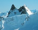
The mountain consists of a narrow north-south trending ridge of fine-grained volcanic rock
and small amounts of fragmental material. It is long and wide with nearly vertical flanks. Mount Fee has two main summits, the southern tower of which is the highest. The summits are separated by a U-shaped crevice that gives them a prominent appearance.
. This volcanic zone forms the central portion of the larger Garibaldi Volcanic Belt
, which extends from the Silverthrone Caldera
in the north to the Watts Point volcano
in the south. The volcanic belt
has formed as a result of ongoing subduction
of the Juan de Fuca Plate
under the North American Plate
at the Cascadia subduction zone
along the British Columbia Coast
. This is a north-south trending fault zone about long, extending off the Pacific Northwest
from Northern California
to southwestern British Columbia. The plates move at a relative rate of over per year at an oblique angle to the subduction zone.
The edifice of Mount Fee is the remains of a volcanic feature that has been significantly eroded by glacial ice. It likely represents a dissected stratovolcano
(also known as a composite volcano) that was larger in area and higher in elevation than its current form. Stratovolcanoes can reach heights of and consist of alternating layers of lava flows, volcanic ash
, cinder
s, blocks and bombs
. During the glacial periods, much of the volcano's original outer cone of pyroclastic material was eroded away by moving layers of ice and rock. The removal of the ejected volcanic material has exposed the dacite
lava that forms the narrow north-south trending ridge of Mount Fee. Black Tusk
, a pinnacle of dark volcanic rock to the southeast, is also interpreted to be the remains of a deeply eroded volcano that was once covered with pyroclastic material. The present day edifice of Mount Fee contains several lava spine
s that reach heights of to above the main ridge.
. As a result, the rocks comprising Mount Fee do not display evidence of interaction with glacial ice; the duration of volcanic events is unknown, and the exact timing of eruptive events is unknown. However, a large variety of volcanoes formed subglacially between 25,000 and 10,000 years ago in the vicinity of Mount Fee, including the lava dome
s of Ember Ridge
to the south.
At least three phases of eruptive activity have been recognized at Mount Fee. The only exposed remnant of Fee's earliest volcanic activity is a minor outcrop of pyroclastic rock. This is evidence of explosive eruption
s during Fee's eruptive history, as well as its first volcanic event. The second volcanic event produced a sequence of volcanic rocks on Fee's eastern flank. This volcanic material was likely deposited when a sequence of lava flows and broken lava fragments erupted from a volcanic vent and moved down the flanks during the construction of the ancestral Mount Fee. Following extensive dissection, renewed volcanism produced a viscous series of lavas on its northern flank. The U-shaped crevice separating the two main summits of Mount Fee separates this lava flow from the main volcanic ridge. The conduit from which these lava flows originated was likely vertical in structure and intruded through older rocks deposited during Fee's earlier volcanic events. This volcanic event was also followed by a period of erosion, and likely one or more glacial period
s. Extensive erosion following the last volcanic event at Mount Fee has created the rugged north-south trending ridge that currently forms a prominent landmark.
and up to 15% vesicles. About 25% of the rocks contain crystal content, including plagioclase
, hornblende
, orthopyroxene, orthoclase
and sporadic quartz
. The orthoclase crystals are interpreted to represent rock fragments that became enveloped during hardening of the dacitic lavas. A portion of the southwestern flank of Mount Fee comprises no volcanic glass, but rather composed of an abnormal cryptocrystalline
matrix
. This indicates that it might have developed as part of a subvolcanic
intrusion
.
ans in the 18th century. It was collected from a number of minor outcrops on the flanks of Mount Fee, as well as at Mount Cayley
and Mount Callaghan
. This material appears in goat hunting sites and at the Elaho rockshelter, collectively dated from about 100 to 8,000 years ago.
In September 1928, Mount Fee was named by British mountaineer Tom Fyles after Charles Fee (1865–1927), who was a member of the British Columbia Mountaineering Club
in Vancouver
at the time. Subsequently, Mount Fee was one of the volcanoes in the Mount Cayley volcanic field illustrated by volcanologist Jack Souther
in 1980. Others included Cauldron Dome
, Mount Cayley, Slag Hill
, Ember Ridge and Ring Mountain, which was titled Crucible Dome at the time. Souther created a geologic map
the following year that displayed the locations of the volcanoes and the regional terrain.
is. This is partly because no major eruptions have taken place in Canada for over a hundred years and the volcano is located in a remote region. As a result, volcano monitoring is less important than dealing with other natural processes, such as tsunami
s, earthquake
s and landslide
s. No recent earthquakes are known to have occurred at Mount Fee. If it were to erupt there would likely be weeks, months or years of warning signs, such as clusters of minor earthquakes that would likely originate less than below the surface. They are generally too small to be felt by people, but the existing network of seismographs has been established to monitor tectonic earthquakes. However, the seismograph network is too far away to provide a good indication of what is happening under the mountain. It may sense an increase in seismic activity if the volcano becomes very restless, but this may only provide a warning for a significant eruption. It might detect activity only once the volcano has started erupting. A significant eruption at Mount Fee would probably have considerable effects, particularly in a region like southwestern British Columbia where the Garibaldi Belt is located in a highly populated area. Because of these concerns, significant support from Canadian university scientists has resulted in the construction of a baseline of knowledge on the state of the Garibaldi volcanoes.
Pacific Ranges
The Pacific Ranges are the southernmost subdivision of the Coast Mountains portion of the Pacific Cordillera. Located entirely within British Columbia, Canada, they run northwest from the lower stretches of the Fraser River to Bella Coola, north of which are the Kitimat Ranges.The Pacific Ranges...
of the Coast Mountains
Coast Mountains
The Coast Mountains are a major mountain range, in the Pacific Coast Ranges, of western North America, extending from southwestern Yukon through the Alaska Panhandle and virtually all of the Coast of British Columbia. They are so-named because of their proximity to the sea coast, and are often...
in southwestern British Columbia
British Columbia
British Columbia is the westernmost of Canada's provinces and is known for its natural beauty, as reflected in its Latin motto, Splendor sine occasu . Its name was chosen by Queen Victoria in 1858...
, Canada
Canada
Canada is a North American country consisting of ten provinces and three territories. Located in the northern part of the continent, it extends from the Atlantic Ocean in the east to the Pacific Ocean in the west, and northward into the Arctic Ocean...
. It is located south of Callaghan Lake and west of the resort town
Resort town
A resort town, sometimes called a resort city or resort destination, is a town or area where tourism or vacationing is a primary component of the local culture and economy...
of Whistler
Whistler, British Columbia
Whistler is a Canadian resort town in the southern Pacific Ranges of the Coast Mountains in the province of British Columbia, Canada, approximately north of Vancouver...
. With a summit elevation of and a topographic prominence
Topographic prominence
In topography, prominence, also known as autonomous height, relative height, shoulder drop , or prime factor , categorizes the height of the mountain's or hill's summit by the elevation between it and the lowest contour line encircling it and no higher summit...
of , it rises above the surrounding rugged landscape on an alpine mountain ridge. This mountain ridge represents the base of a north-south trending volcanic field
Volcanic field
A volcanic field is an area of the Earth's crust that is prone to localized volcanic activity. They usually contain 10 to 100 volcanoes, such as cinder cones and are usually in clusters. Lava flows may also occur...
which Mount Fee occupies.
The mountain consists of a narrow north-south trending ridge of fine-grained volcanic rock
Volcanic rock
Volcanic rock is a rock formed from magma erupted from a volcano. In other words, it is an igneous rock of volcanic origin...
and small amounts of fragmental material. It is long and wide with nearly vertical flanks. Mount Fee has two main summits, the southern tower of which is the highest. The summits are separated by a U-shaped crevice that gives them a prominent appearance.
Geology
Mount Fee is one of the southernmost volcanoes in the Mount Cayley volcanic fieldMount Cayley volcanic field
The Mount Cayley volcanic field is a remote volcanic zone on the South Coast of British Columbia, Canada, stretching from the Pemberton Icefield to the Squamish River. It forms a segment of the Garibaldi Volcanic Belt, the Canadian portion of the Cascade Volcanic Arc, which extends from Northern...
. This volcanic zone forms the central portion of the larger Garibaldi Volcanic Belt
Garibaldi Volcanic Belt
The Garibaldi Volcanic Belt, also called the Canadian Cascade Arc, is a northwest-southeast trending volcanic chain in the Pacific Ranges of the Coast Mountains that extends from Watts Point in the south to the Ha-Iltzuk Icefield in the north. This chain of volcanoes is located in southwestern...
, which extends from the Silverthrone Caldera
Silverthrone Caldera
The Silverthrone Caldera is a potentially active caldera complex in southwestern British Columbia, Canada, located over northwest of the city of Vancouver and about west of Mount Waddington in the Pacific Ranges of the Coast Mountains. The caldera is one of the largest of the few calderas in...
in the north to the Watts Point volcano
Watts Point volcanic centre
The Watts Point volcanic centre is a small outcrop of Pleistocene age volcanic rock at Watts Point in British Columbia, Canada, about south of Squamish and north of Vancouver, and just north of Britannia Beach. It is the southernmost volcanic zone in the Squamish volcanic field and of the...
in the south. The volcanic belt
Volcanic belt
A volcanic belt is a large volcanically active region. Other terms are used for smaller areas of activity, such as volcanic fields. Volcanic belts are found above zones of unusually high temperature where magma is created by partial melting of solid material in the Earth's crust and upper mantle....
has formed as a result of ongoing subduction
Subduction
In geology, subduction is the process that takes place at convergent boundaries by which one tectonic plate moves under another tectonic plate, sinking into the Earth's mantle, as the plates converge. These 3D regions of mantle downwellings are known as "Subduction Zones"...
of the Juan de Fuca Plate
Juan de Fuca Plate
The Juan de Fuca Plate, named after the explorer of the same name, is a tectonic plate, generated from the Juan de Fuca Ridge, and subducting under the northerly portion of the western side of the North American Plate at the Cascadia subduction zone...
under the North American Plate
North American Plate
The North American Plate is a tectonic plate covering most of North America, Greenland, Cuba, Bahamas, and parts of Siberia, Japan and Iceland. It extends eastward to the Mid-Atlantic Ridge and westward to the Chersky Range in eastern Siberia. The plate includes both continental and oceanic crust...
at the Cascadia subduction zone
Cascadia subduction zone
The Cascadia subduction zone is a subduction zone, a type of convergent plate boundary that stretches from northern Vancouver Island to northern California. It is a very long sloping fault that separates the Juan de Fuca and North America plates.New ocean floor is being created offshore of...
along the British Columbia Coast
British Columbia Coast
The British Columbia Coast or BC Coast is Canada's western continental coastline on the Pacific Ocean. The usage is synonymous with the term West Coast of Canada....
. This is a north-south trending fault zone about long, extending off the Pacific Northwest
Pacific Northwest
The Pacific Northwest is a region in northwestern North America, bounded by the Pacific Ocean to the west and, loosely, by the Rocky Mountains on the east. Definitions of the region vary and there is no commonly agreed upon boundary, even among Pacific Northwesterners. A common concept of the...
from Northern California
Northern California
Northern California is the northern portion of the U.S. state of California. The San Francisco Bay Area , and Sacramento as well as its metropolitan area are the main population centers...
to southwestern British Columbia. The plates move at a relative rate of over per year at an oblique angle to the subduction zone.
The edifice of Mount Fee is the remains of a volcanic feature that has been significantly eroded by glacial ice. It likely represents a dissected stratovolcano
Stratovolcano
A stratovolcano, also known as a composite volcano, is a tall, conical volcano built up by many layers of hardened lava, tephra, pumice, and volcanic ash. Unlike shield volcanoes, stratovolcanoes are characterized by a steep profile and periodic, explosive eruptions...
(also known as a composite volcano) that was larger in area and higher in elevation than its current form. Stratovolcanoes can reach heights of and consist of alternating layers of lava flows, volcanic ash
Volcanic ash
Volcanic ash consists of small tephra, which are bits of pulverized rock and glass created by volcanic eruptions, less than in diameter. There are three mechanisms of volcanic ash formation: gas release under decompression causing magmatic eruptions; thermal contraction from chilling on contact...
, cinder
Cinder
A cinder is a pyroclastic material. Cinders are extrusive igneous rocks. Cinders are similar to pumice, which has so many cavities and is such low-density that it can float on water...
s, blocks and bombs
Volcanic bomb
A volcanic bomb is a mass of molten rock larger than 65 mm in diameter, formed when a volcano ejects viscous fragments of lava during an eruption. They cool into solid fragments before they reach the ground. Because volcanic bombs cool after they leave the volcano, they do not have grains...
. During the glacial periods, much of the volcano's original outer cone of pyroclastic material was eroded away by moving layers of ice and rock. The removal of the ejected volcanic material has exposed the dacite
Dacite
Dacite is an igneous, volcanic rock. It has an aphanitic to porphyritic texture and is intermediate in composition between andesite and rhyolite. The relative proportions of feldspars and quartz in dacite, and in many other volcanic rocks, are illustrated in the QAPF diagram...
lava that forms the narrow north-south trending ridge of Mount Fee. Black Tusk
Black Tusk
Black Tusk is a remarkably abrupt pinnacle of volcanic rock located in Garibaldi Provincial Park of British Columbia, Canada. At above sea level, the upper spire is visible from a great distance in all directions. It is particularly noticeable from the Sea-to-Sky Highway just south of Whistler,...
, a pinnacle of dark volcanic rock to the southeast, is also interpreted to be the remains of a deeply eroded volcano that was once covered with pyroclastic material. The present day edifice of Mount Fee contains several lava spine
Lava spine
A lava spine is a vertically growing monolith of viscous lava that is slowly forced from a volcanic vent, such as those growing on a lava dome . It may also be considered a kind of dome called a spiny dome . In February of 1983, the dome activity of Mount St...
s that reach heights of to above the main ridge.
Eruptive history
Volcanic activity at Mount Fee is among the oldest in the Mount Cayley volcanic field. Its volcanic rocks remain undated, but the large amount of dissection and evidence of glacial ice overriding the volcano indicates that it formed more than 75,000 years ago before the Wisconsinan GlaciationWisconsinan glaciation
The Wisconsin Glacial Episode was the most recent major advance of the North American Laurentide ice sheet. Globally, this advance is known as the last glacial period. The Wisconsin glaciation extended from approximately 110,000 to 10,000 years ago, between the Eemian interglacial and the current...
. As a result, the rocks comprising Mount Fee do not display evidence of interaction with glacial ice; the duration of volcanic events is unknown, and the exact timing of eruptive events is unknown. However, a large variety of volcanoes formed subglacially between 25,000 and 10,000 years ago in the vicinity of Mount Fee, including the lava dome
Lava dome
|250px|thumb|right|Image of the [[rhyolitic]] lava dome of [[Chaitén Volcano]] during its 2008–2009 eruption.In volcanology, a lava dome is a roughly circular mound-shaped protrusion resulting from the slow extrusion of viscous lava from a volcano...
s of Ember Ridge
Ember Ridge
Ember Ridge is a volcanic mountain ridge associated with the Mount Cayley volcanic field in British Columbia, Canada. Ember Ridge is made of a series of steep-sided domes of glassy, complexly jointed, hornblende-phyric basalt with the most recent eruptions during the Holocene...
to the south.
At least three phases of eruptive activity have been recognized at Mount Fee. The only exposed remnant of Fee's earliest volcanic activity is a minor outcrop of pyroclastic rock. This is evidence of explosive eruption
Explosive eruption
An explosive eruption is a volcanic term to describe a violent, explosive type of eruption. Mount St. Helens in 1980 was an example. Such an eruption is driven by gas accumulating under great pressure. Driven by hot rising magma, it interacts with ground water until the pressure increases to the...
s during Fee's eruptive history, as well as its first volcanic event. The second volcanic event produced a sequence of volcanic rocks on Fee's eastern flank. This volcanic material was likely deposited when a sequence of lava flows and broken lava fragments erupted from a volcanic vent and moved down the flanks during the construction of the ancestral Mount Fee. Following extensive dissection, renewed volcanism produced a viscous series of lavas on its northern flank. The U-shaped crevice separating the two main summits of Mount Fee separates this lava flow from the main volcanic ridge. The conduit from which these lava flows originated was likely vertical in structure and intruded through older rocks deposited during Fee's earlier volcanic events. This volcanic event was also followed by a period of erosion, and likely one or more glacial period
Glacial period
A glacial period is an interval of time within an ice age that is marked by colder temperatures and glacier advances. Interglacials, on the other hand, are periods of warmer climate within an ice age...
s. Extensive erosion following the last volcanic event at Mount Fee has created the rugged north-south trending ridge that currently forms a prominent landmark.
Petrography
The dacite and rhyodacite rocks comprising Mount Fee contain up to 70% brown volcanic glassVolcanic glass
Volcanic glass is the amorphous product of rapidly cooling magma. Like all types of glass, it is a state of matter intermediate between the close-packed, highly ordered array of a crystal and the highly disordered array of gas...
and up to 15% vesicles. About 25% of the rocks contain crystal content, including plagioclase
Plagioclase
Plagioclase is an important series of tectosilicate minerals within the feldspar family. Rather than referring to a particular mineral with a specific chemical composition, plagioclase is a solid solution series, more properly known as the plagioclase feldspar series...
, hornblende
Hornblende
Hornblende is a complex inosilicate series of minerals .It is not a recognized mineral in its own right, but the name is used as a general or field term, to refer to a dark amphibole....
, orthopyroxene, orthoclase
Orthoclase
Orthoclase is an important tectosilicate mineral which forms igneous rock. The name is from the Greek for "straight fracture," because its two cleavage planes are at right angles to each other. Alternate names are alkali feldspar and potassium feldspar...
and sporadic quartz
Quartz
Quartz is the second-most-abundant mineral in the Earth's continental crust, after feldspar. It is made up of a continuous framework of SiO4 silicon–oxygen tetrahedra, with each oxygen being shared between two tetrahedra, giving an overall formula SiO2. There are many different varieties of quartz,...
. The orthoclase crystals are interpreted to represent rock fragments that became enveloped during hardening of the dacitic lavas. A portion of the southwestern flank of Mount Fee comprises no volcanic glass, but rather composed of an abnormal cryptocrystalline
Cryptocrystalline
Cryptocrystalline is a rock texture made up of such minute crystals that its crystalline nature is only vaguely revealed even microscopically in thin section by transmitted polarized light. Among the sedimentary rocks, chert and flint are cryptocrystalline. Carbonado, a form of diamond, is also...
matrix
Matrix (geology)
The matrix or groundmass of rock is the finer grained mass of material in which larger grains, crystals or clasts are embedded.The matrix of an igneous rock consists of finer grained, often microscopic, crystals in which larger crystals are embedded. This porphyritic texture is indicative of...
. This indicates that it might have developed as part of a subvolcanic
Subvolcanic rock
A subvolcanic rock, also known as a hypabyssal rock, is an igneous rock that originates at medium to shallow depths within the crust and contain intermediate grain size and often porphyritic texture. They have textures between volcanic and plutonic rocks. Subvolcanic rocks include diabase and...
intrusion
Intrusion
An intrusion is liquid rock that forms under Earth's surface. Magma from under the surface is slowly pushed up from deep within the earth into any cracks or spaces it can find, sometimes pushing existing country rock out of the way, a process that can take millions of years. As the rock slowly...
.
Habitation
Human habitation at Mount Fee extends from hundreds to thousands of years ago. Glassy volcanic rocks, such as rhyodacite, were widely used to make knives, chisels, adzes and other sharp tools before the arrival of EuropeEurope
Europe is, by convention, one of the world's seven continents. Comprising the westernmost peninsula of Eurasia, Europe is generally 'divided' from Asia to its east by the watershed divides of the Ural and Caucasus Mountains, the Ural River, the Caspian and Black Seas, and the waterways connecting...
ans in the 18th century. It was collected from a number of minor outcrops on the flanks of Mount Fee, as well as at Mount Cayley
Mount Cayley
Mount Cayley is a potentially active stratovolcano in Squamish-Lillooet Regional District of southwestern British Columbia, Canada. Located north of Squamish and west of Whistler in the Pacific Ranges of the Coast Mountains, it rises above the Squamish River to the west and above the Cheakamus...
and Mount Callaghan
Mount Callaghan
Mount Callaghan is a volcanic peak located east of the headwaters of the Squamish River, just northeast of the Powder Mountain Icefield and just south of the Pemberton Icefield in the Sea to Sky Country of southwestern British Columbia, Canada, about 20 km directly west of the Resort...
. This material appears in goat hunting sites and at the Elaho rockshelter, collectively dated from about 100 to 8,000 years ago.
In September 1928, Mount Fee was named by British mountaineer Tom Fyles after Charles Fee (1865–1927), who was a member of the British Columbia Mountaineering Club
British Columbia Mountaineering Club
The British Columbia Mountaineering Club is a mountaineering organization, based in Vancouver, British Columbia. Founded on October 28, 1907 as the Vancouver Mountaineering Club, it became one of the centres of Canadian Mountaineering, particularly in the Coast Mountains of British Columbia...
in Vancouver
Vancouver
Vancouver is a coastal seaport city on the mainland of British Columbia, Canada. It is the hub of Greater Vancouver, which, with over 2.3 million residents, is the third most populous metropolitan area in the country,...
at the time. Subsequently, Mount Fee was one of the volcanoes in the Mount Cayley volcanic field illustrated by volcanologist Jack Souther
Jack Souther
Jack Souther is an Bancroft Award winning American-Canadian volcanologist of the Geological Survey of Canada. He is a leading authority on geothermal resources and volcanism in the Canadian Cordillera. Souther has long been in demand as a professor to lay audiences because of his ability to give...
in 1980. Others included Cauldron Dome
Cauldron Dome
Cauldron Dome is a tuya in the Mount Cayley volcanic field, British Columbia, Canada. Cauldron Dome is made of coarsely plagioclase-orthophyroxene-phyric andesite lava flows and last erupted during the Holocene...
, Mount Cayley, Slag Hill
Slag Hill
Slag Hill is a subglacial volcano associated with the Mount Cayley volcanic field in British Columbia, Canada. It consists of glassy, augite-phyric basaltic andesite in steep-sided, glassy, finely jointed domes and one small, flat-topped bluff. The finely jointed domes are similar to those of Ember...
, Ember Ridge and Ring Mountain, which was titled Crucible Dome at the time. Souther created a geologic map
Geologic map
A geologic map or geological map is a special-purpose map made to show geological features. Rock units or geologic strata are shown by color or symbols to indicate where they are exposed at the surface...
the following year that displayed the locations of the volcanoes and the regional terrain.
Monitoring
Like other volcanoes in the Garibaldi Belt, Mount Fee is not monitored closely enough by the Geological Survey of Canada to ascertain how active its magma chamberMagma chamber
A magma chamber is a large underground pool of molten rock found beneath the surface of the Earth. The molten rock in such a chamber is under great pressure, and given enough time, that pressure can gradually fracture the rock around it creating outlets for the magma...
is. This is partly because no major eruptions have taken place in Canada for over a hundred years and the volcano is located in a remote region. As a result, volcano monitoring is less important than dealing with other natural processes, such as tsunami
Tsunami
A tsunami is a series of water waves caused by the displacement of a large volume of a body of water, typically an ocean or a large lake...
s, earthquake
Earthquake
An earthquake is the result of a sudden release of energy in the Earth's crust that creates seismic waves. The seismicity, seismism or seismic activity of an area refers to the frequency, type and size of earthquakes experienced over a period of time...
s and landslide
Landslide
A landslide or landslip is a geological phenomenon which includes a wide range of ground movement, such as rockfalls, deep failure of slopes and shallow debris flows, which can occur in offshore, coastal and onshore environments...
s. No recent earthquakes are known to have occurred at Mount Fee. If it were to erupt there would likely be weeks, months or years of warning signs, such as clusters of minor earthquakes that would likely originate less than below the surface. They are generally too small to be felt by people, but the existing network of seismographs has been established to monitor tectonic earthquakes. However, the seismograph network is too far away to provide a good indication of what is happening under the mountain. It may sense an increase in seismic activity if the volcano becomes very restless, but this may only provide a warning for a significant eruption. It might detect activity only once the volcano has started erupting. A significant eruption at Mount Fee would probably have considerable effects, particularly in a region like southwestern British Columbia where the Garibaldi Belt is located in a highly populated area. Because of these concerns, significant support from Canadian university scientists has resulted in the construction of a baseline of knowledge on the state of the Garibaldi volcanoes.
See also
- List of Cascade volcanoes
- List of volcanoes of Canada
- Volcanism of Canada
- Volcanism of Western CanadaVolcanism of Western CanadaVolcanism of Western Canada produces lava flows, lava plateaus, lava domes, cinder cones, stratovolcanoes, shield volcanoes, submarine volcanoes, calderas, diatremes and maars, along with examples of more less common volcanic forms such as tuyas and subglacial mounds.-Volcanic belts:*Anahim...
External links
- Garibaldi Volcanic Belt (Mount Cayley area) Map of Canadian volcanoes. Natural Resources CanadaNatural Resources CanadaThe Department of Natural Resources , operating under the FIP applied title Natural Resources Canada , is the ministry of the government of Canada responsible for natural resources, energy, minerals and metals, forests, earth sciences, mapping and remote sensing...
. 2005-08-20