

Mount Cayley volcanic field
Encyclopedia
The Mount Cayley volcanic field is a remote volcanic zone on the South Coast
of British Columbia
, Canada
, stretching 31 km (19.3 mi) from the Pemberton Icefield
to the Squamish River
. It forms a segment of the Garibaldi Volcanic Belt
, the Canadian portion of the Cascade Volcanic Arc
, which extends from Northern California
to southwestern British Columbia. Most of the Cayley volcanoes were formed during periods of volcanism
under sheets of glacial ice throughout the last glacial period. These subglacial eruption
s formed steep, flat-topped volcanoes
and subglacial lava dome
s, most of which have been entirely exposed by deglaciation. However, at least two volcanoes predate the last glacial period and both are highly eroded. The field gets its name from Mount Cayley
, the largest and most persistent volcano, located at the southern end of the Powder Mountain Icefield
. This icefield covers much of the central portion of the volcanic field
and is one of the several glacial fields in the Pacific Ranges
of the Coast Mountains
.
Eruptions along the length of the field began between 1.6 and 5.3 million years ago. At least 23 eruptions have occurred throughout its eruptive history. This volcanic activity ranged from effusive
to explosive
, with magma compositions ranging from basalt
ic to rhyolitic
. Because the Mount Cayley volcanic field has a high elevation
and consists of a cluster of mostly high altitude, non-overlapping volcanoes, subglacial activity is likely to have occurred under less than 800 m (2,624.7 ft) of glacial ice. The style of this glaciation promoted meltwater
escape during eruptions. The steep profile of the volcanic field and its subglacial landforms support this hypothesis. As a result, volcanic features in the field that interacted with glacial ice lack rocks that display evidence of abundant water during eruption, such as hyaloclastite
and pillow lava
.
Of the entire volcanic field, the southern portion has the most known volcanoes. Here, at least 11 of them are situated on top of a long narrow mountain ridge and in adjacent river valley
s. The central portion contains at least five volcanoes situated at the Powder Mountain Icefield. To the north, two volcanoes form a sparse area of volcanism. Many of these volcanoes were formed between 0.01 and 1.6 million years ago, some of which show evidence of volcanic activity in the past 10,000 years.
 The Mount Cayley volcanic field formed as a result of the ongoing subduction
of the Juan de Fuca Plate
under the North American Plate
at the Cascadia subduction zone along the British Columbia Coast. This is a 1094 km (679.8 mi) long fault zone running 80 km (49.7 mi) off the Pacific Northwest
from Northern California
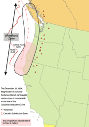
to southwestern British Columbia. The plates move at a relative rate of over 10 mm (0.393700787401575 in) per year at an oblique angle to the subduction zone. Because of the very large fault area, the Cascadia subduction zone can produce large earthquake
s of magnitude
7.0 or greater. The interface between the Juan de Fuca and North American plates remains locked for periods of roughly 500 years. During these periods, stress builds up on the interface between the plates and causes uplift of the North American margin. When the plate finally slips, the 500 years of stored energy are released in a massive earthquake.
Unlike most subduction zones worldwide, there is no deep oceanic trench
present along the continental margin
in Cascadia. The reason is that the mouth of the Columbia River
empties directly into the subduction zone and deposits silt at the bottom of the Pacific Ocean
, burying the oceanic trench. Massive floods from prehistoric Glacial Lake Missoula
during the Late Pleistocene
also deposited large amounts of sediment
into the trench. However, in common with other subduction zones, the outer margin is slowly being compressed, similar to a giant spring. When the stored energy is suddenly released by slippage across the fault at irregular intervals, the Cascadia subduction zone can create very large earthquakes, such as the magnitude 9.0 Cascadia earthquake on January 26, 1700. However, earthquakes along the Cascadia subduction zone are fewer than expected and there is evidence of a decline in volcanic activity over the past few million years. The probable explanation lies in the rate of convergence between the Juan de Fuca and North American plates. These two tectonic plates currently converge 3 cm (1.2 in) to 4 cm (1.6 in) per year. This is only about half the rate of convergence from seven million years ago.
Scientists have estimated that there have been at least 13 significant earthquakes along the Cascadia subduction zone in the past 6,000 years. The most recent, the 1700 Cascadia earthquake, was recorded in the oral traditions of the First Nations
people on Vancouver Island
. It caused considerable tremors and a massive tsunami
that traveled across the Pacific Ocean. The significant shaking associated with this earthquake demolished houses of the Cowichan Tribes
on Vancouver Island and caused several landslide
s. Shaking due to this earthquake made it too difficult for the Cowichan people to stand, and the tremors were so lengthy that they were sickened. The tsunami created by the earthquake ultimately devastated a winter village at Pachena Bay, killing all the people that lived there. The 1700 Cascadia earthquake caused near-shore subsidence, submerging marsh
es and forests on the coast that were later buried under more recent debris.
. At least two geological units compose the edifice. Slag Hill proper consists of andesite
lava flows and small amounts of pyroclastic rock
. Lying on the western portion of Slag Hill is a lava flow that likely erupted less than 10,000 years ago due to the lack of features indicating volcano-ice interactions. The Slag Hill flow-dominated tuya 900 m (2,952.8 ft) northeast of Slag Hill proper consists of a flat-topped, steep-sided pile of andesite. It protrudes through remnants of volcanic material erupted from Slag Hill proper, but it represents a separate volcanic vent due to its geographical appearance. This small subglacial volcano possibly formed between 25,000 and 10,000 years ago throughout the waning stages of the Fraser Glaciation.
Cauldron Dome
, a subglacial volcano north of Mount Cayley, lies west of the Powder Mountain Icefield. Like Slag Hill, it is composed of two geological units. Upper Cauldron Dome is a flat-topped, oval-shaped pile of at least five andesite lava flows that resembles a tuya. The five andesite flows are columnar jointed and were likely extruded through glacial ice. The latest volcanic activity might have occurred between 10,000 and 25,000 years ago when this area was still influenced by glacial ice of the Fraser Glaciation. Lower Cauldron Dome, the youngest unit comprising the entire Cauldron Dome subglacial volcano, consists of a flat-topped, steep-sided pile of andesite lava flows 1800 m (5,905.5 ft) long and a maximum thickness of 220 m (721.8 ft). These volcanics were extruded about 10,000 years ago during the waning stages of the Fraser Glaciation from a vent adjacent to upper Cauldron Dome that is currently buried under glacial ice.
 Ring Mountain, a flow-dominated tuya lying at the northern portion of the Mount Cayley volcanic field, consists of a pile of at least five andesite lava flows lying on a mountain ridge. Its steep-sided flanks reach heights of 500 m (1,640.4 ft) and are composed of volcanic rubble. This makes it impossible to measure its exact base elevation or how many lava flows constitute the edifice. With a summit elevation of 2192 m (7,191.6 ft), Ring Mountain had its last volcanic activity between 25,000 and 10,000 years ago when the Fraser Glaciation was close to its maximum. Northwest of Ring Mountain lies a minor andesite lava flow. Its chemistry is somewhat unlike other andesite flows comprising Ring Mountain, but it probably erupted from a volcanic vent adjacent to or at Ring Mountain. The part of it that lies higher in elevation contains some features that indicate lava-ice interactions, while the lower-elevation portion of it does not. Therefore, this minor lava flow was likely extruded after Ring Mountain formed but when glacial ice covered a broader area than it does to this day, and that the lava flowed beyond the region in which glacial ice existed at that time.
To the north lies Little Ring Mountain, another flow-dominated tuya lying at the northern portion of the Mount Cayley volcanic field. It consists of a pile of at least three andesite lava flows lying on a mountain ridge. Its steep-sided flanks reach heights of 240 m (787.4 ft) and are composed of volcanic rubble. This makes it impossible to measure its exact base elevation or how many lava flows comprise the edifice. With a summit elevation of 2147 m (7,044 ft), Little Ring Mountain had its last volcanic activity between 25,000 and 10,000 years ago when the Fraser Glaciation was close to its maximum.
Ember Ridge
, a mountain ridge between Tricouni Peak
and Mount Fee, consists of at least eight lava domes composed of andesite. They were likely formed between 25,000 and 10,000 years ago when lava erupted beneath glacial ice of the Fraser Glaciation. Their current structures are comparable to their original forms due to the minimal degree of erosion. As a result, the domes display the shapes and columnar joints typical of subglacial volcanoes. The random shapes of the Ember Ridge domes are the result of erupted lava taking advantage of former ice pockets, eruptions taking place on uneven surfaces, subsidence of the domes during volcanic activity to create rubble and separation of older columnar units during more recent eruptions. The northern dome, known as Ember Ridge North, covers the summit and eastern flank of the mountain ridge. It comprises at least one lava flow that reaches a thickness of 100 m (328.1 ft), as well as the thinnest columnar units in the Mount Cayley volcanic field. The small size of the columnar joints indicates that the erupted lava was cooled immediately and are mainly located on the dome's summit. Ember Ridge Northeast, the smallest subglacial dome of Ember Ridge, comprises one lava flow that has a thickness no more than 40 m (131.2 ft). Ember Ridge Northwest, the most roughly circular subglacial dome, comprises at least one lava flow. Ember Ridge Southeast is the most complex of the Ember Ridge domes, consisting of a series of lava flows with a thickness of 60 m (196.9 ft). It is also the only Ember Ridge dome that contains large amounts of rubble. Ember Ridge Southwest comprises at least one lava flow that reaches a thickness of 80 m (262.5 ft). It is the only subglacial dome of Ember Ridge that contains hyaloclastite. Ember Ridge West comprises only one lava flow that reaches a thickness of 60 m (196.9 ft).
Mount Brew
, 18 km (11.2 mi) southwest of the resort town
of Whistler
, is a 1757 m (5,764.4 ft) high lava dome composed of andesite or dacite that probably formed subglacially between 25,000 and 10,000 years ago. It contains two masses of rock that might resemble ice-marginal lava flows. These edifices have not been studied in detail but they could have formed during the same period as the Ember Ridge subglacial domes due to their structures, columnar joints and compositions.
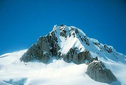
 The Mount Cayley massif
, 2385 m (7,824.8 ft) in elevation, is the largest and most persistent volcano in the Mount Cayley volcanic field. It is a highly eroded stratovolcano composed of dacite and rhyodacite
lava that was deposited during three phases of volcanic activity. The first eruptive phase started about four million years ago with the eruption of dacite lava flows and pyroclastic rock. This resulted in the creation of the Mount Cayley proper. Subsequent volcanism during this volcanic phase constructed a significant lava dome. This acts like a volcanic plug and composes the lava spine
s that currently form pinnacles on Cayley's rugged summit. After the Mount Cayley proper was constructed, lava flows, tephra
and welded dacite rubble was erupted. This second phase of activity million years ago resulted in the creation of the Vulcan's Thumb
, a craggy volcanic ridge on the southern flank of the Mount Cayley proper. Lengthy dissection from an extended period of erosion demolished much of the original stratovolcano. Volcanic activity after this prolonged period of erosion produced thick dacite lava flows from parasitic vents 300,000 years ago that extended into the Turbid
and Shovelnose Creek
valleys near the Squamish River. This subsequently created two minor parasitic lava domes 200,000 years ago. These three volcanic events in contrast to several others around Cayley in that they do not show signs of interaction with glacial ice.
Immediately southeast of Mount Cayley lies Mount Fee
, an extensively eroded volcano containing a north-south trending ridge. It has an elevation of 2162 m (7,093.2 ft) and is one of the older volcanic features in the Mount Cayley volcanic field. Its volcanics are undated, but its large amount of dissection and evidence of glacial ice overriding the volcano indicates that it formed more than 75,000 years ago before the Wisconsinan Glaciation
. Therefore, volcanism at Mount Fee does not display evidence of interaction with glacial ice. The remaining products from Fee's earliest volcanic activity is a minor portion of pyroclastic rock. This is evidence of explosive volcanism from Fee's eruptive history, as well as its first volcanic event. The second volcanic event produced a sequence of lavas and breccias on the eastern flank of the main ridge. These volcanics were likely deposited when a sequence of lava flows and broken lava fragments erupted from a volcanic vent and moved down the flanks during the construction of a large volcano. Following extensive dissection, renewed volcanism produced a viscous series of lava flows forming its narrow, flat-topped, steep-sided northern limit and the northern end of the main ridge. The conduit for which these lava flows originated from was likely vertical in structure and intruded through older volcanics deposited during Fee's earlier volcanic events. This volcanic event was also followed by a period of erosion, and likely one or more glacial periods. Extensive erosion following the last volcanic event at Mount Fee has created the rugged north-south trending ridge that currently forms a prominent landmark.
Pali Dome
, located north and northeast of Mount Cayley, is an eroded volcano in the central Mount Cayley volcanic field. Like Cauldron Dome, it consists of two geological units. Pail Dome East is composed of a mass of andesite lava flows and small amounts of pyroclastic material. It lies on the eastern portion of the Powder Mountain Icefield. Much of the lava flows form gentle topography at high elevations but terminate in finely jointed vertical cliffs at low elevations. The first volcanic activity likely occurred about 25,000 years ago, but it could also be significantly older. The most recent volcanic activity produced a series of lava flows that were erupted when the vent area was not covered by glacial ice. However, the flows show evidence of interaction with glacial ice in their lower units. This indicates that the lavas were erupted about 10,000 years ago during the waning stages of the Fraser Glaciation. The ice-marginal lava flows reach thicknesses of up to 100 m (328.1 ft). Pali Dome West consists of at least three andesite lava flows and small amounts of pyroclastic material; its vent presently buried under glacial ice. At least three eruptions have occurred at Pali Dome East. The age of the first volcanic eruption is unknown, but it could have occurred in the past 10,000 years. The second eruption produced a lava flow that was erupted when the vent area was not buried under glacial ice. However, the flow does show evidence of interaction with glacial ice at its lower unit. This indicates that the lavas were erupted during the waning stages of the Fraser Glaciation. The third and most recent eruption produced another lava flow that was largely erupted above glacial ice, but was probably constrained on its northern margin by a small glacier. Unlike the lava flow that was erupted during the second eruption, this lava flow was not impounded by glacial ice at its lower unit. This suggests that it erupted less than 10,000 years ago when the regional Fraser Glaciation retreated.
lava flows are deposited south of Tricouni Peak
. One of these sequences, known as Tricouni Southwest
, creates a cliff on the eastern side of a north-south trending channel with a depth of 200 m (656.2 ft) adjacent to the High Falls Creek
mouth. The eastern flank of the lava flow, outside the High Falls Creek channel, has a more constant structure. Several fine-scale columnar joints and the overall structure of the lava flow suggest that its western portion, along the length of the channel, ponded against glacial ice. Near its southern unit, lava oozed into cracks in the glacial ice. This has been identified by the existence of spire-like cooling formations, although many of these edifices have been destroyed by erosional processes. Other features that indicate the lava ponded against glacial ice include its unusually thick structure and its steep cliffs. Therefore, the Tricouni Southwest lava flow was erupted about 10,000 years ago when the regional Fraser Glaciation was retreating. The explanation for the western portion displaying ice-contact features while the eastern portion does not is likely because its western flank lies in a north-south trending channel, which would have been able to maintain smaller amounts of solar heat than its unsheltered eastern flank. As a result, the western portion of the lava flow records glaciation during a period when the eastern slopes were free from glacial ice.
Tricouni Southeast, another volcanic sequence south of Tricouni Peak, consists of at least four andesite or dacite lava flows that outcrop as several small cliffs and bluffs on extensively vegetated flanks. They reach thicknesses of 100 m (328.1 ft) and contain small amounts of hyaloclastite. The feeder of their origins has not been discovered but is likely located at the summit of the mound. These lavas form ice-marginal edifies, suggesting that every lava flow was erupted about 10,000 years ago when the vast Cordilleran Ice Sheet was retreating and remains of glacial ice was sparse.
Exposed along the Cheakamus River
and its tributaries
are the Cheakamus Valley basalts
. Although not necessarily mapped as part of the Cayley field, this sequence of basaltic lava flows is geologically similar and comparable in age to volcanic features that are part of this volcanic field. At least four basaltic flows comprise the sequence and were deposited during periods of volcanic activity from an unknown vent between 0.01 and 1.6 million years ago. Pillow lava is abundant along the bases the flows, some of which are underlain by hyaloclastite breccia. In 1958, Canadian volcanologist Bill Mathews
suggested that the lava flows were erupted during periods of subglacial activity and traveled through trenches or tunnels melted in glacial ice of the Fraser Glaciation. Mathews based this on the age of the underlying till, the existence of pillow lava close to the bottom of some lavas, indicating subaqueous volcanism, the columnar jointing at the edges of the lavas, indicating rapid cooling, and the absence of apparent palaeogeography
.
with a trachytic
matrix
of plagioclase
. About 35% of Ember Ridge andesite contains phenocryst
s of hornblende
, augite
, plagioclase and orthopyroxene and exist as isolated crystals and clots. A feature south of Ember Ridge, unofficially known as Betty's Bump, comprises andesite with phenocrysts of plagioclase, augite and olivine
. Dark brown volcanic glass composes the Betty's Bump andesite as much as 20%. The relationship of Betty's Bump with Ember Ridge is unclear but it likely represents a separate volcanic feature due to its topographic isolation.
Little Ring Mountain at the northern end of the field contains at least 70% brown volcanic glass with isolated phenocrysts of plagioclase. Vesicular texture
s are up to 5%, suggesting that the lava erupted subaerially
. Probable xenocrysts of quartz
have been identified at the volcano. At least one xenolith
fragment has been found in loose rubble at the volcano and included several quartz xenocrysts and polycrystalline quartz xenoliths in a glassy matrix with trachytic plagioclase.
The dacite volcanics composing Mount Fee contain brown volcanic glass as much as 70% and vesicular textures as much as 15%. About 25% of the volcanics contain crystal content, including plagioclase, hornblende, orthopyroxene, orthoclase
and sporadic quartz. The orthoclase crystals are interpreted to represent rock fragments that became enveloped during hardening of the dacitic lavas. A portion of the southwestern flank of Mount Fee comprises no volcanic glass, but rather composed of an abnormal cryptocrystalline
matrix. This indicates that it might have developed as part of a subvolcanic
intrusion.
At Ring Mountain, andesite comprises 70% brown volcanic glass and vesicular textures as much as 15%. The plagioclastic matrix is trachytic. Augite, biotite, plagioclase and hornblende occur as microphenocrysts and comprise 1% to 7% of the andesite. Small qualities of quartz are common and occur as microxenocrysts. Microxenocrysts of orthoclase likely exist in andesite at Ring Mountain.
Andesite at Slag Hill consists of 70% dark brown volcanic glass with varied degrees of trachytic texture in the plagioclastic matrix and less than 5% of the andesite comprises vesicular textures. Plagioclase, hornblende and augite are mostly in form as phenocrysts and comprise 1% to 10% of the andesite. Orthoclase crystals are found occasionally and they likely represent xenocrysts.
 At least four seismic events have occurred at Mount Cayley since 1985 and is the only volcano that has recorded seismic activity in the field. This suggests that the volcano still contains an active magma system, indicating the possibility of future eruptive activity. Although the available data does not allow a clear conclusion, this observation indicates that some volcanoes in the Mount Cayley field may be active, with significant potential hazards. This seismic activity correlates both with some of Canada's most youthful volcanoes and with long-lived volcanoes with a history of significant explosive activity, such as Mount Cayley. Recent seismic imaging from Natural Resources Canada
employess supported lithoprobe studies in the region of Mount Cayley that created a large reflector interpreted to be a pool of molten rock roughly 15 km (9.3 mi) below the surface. It is estimated to be 3 km (1.9 mi) long and 1 km (0.621372736649807 mi) wide with a thickness of less than 1.6 km (0.994196378639691 mi). The reflector is understood to be a sill
complex associated with the formation of Mount Cayley. However, the available data does not rule out the probability of it being a body of molten rock created by dehydrating of the subducted Juan de Fuca Plate. It is located just beneath the weak lithosphere
like those found under subduction zone volcanoes in Japan
.
At least five hot spring
s exist in valleys near Mount Cayley, providing more evidence for magmatic activity. This includes springs found at Shovelnose Creek and Turbid Creek on the southern flank of Mount Cayley and Brandywine Creek
on the eastern flank of the volcanic field. They are generally found in areas of volcanic activity that are geologically young. As the regional surface water percolates downward through rocks below the Mount Cayley field, it reaches areas of high temperatures surrounding an active or recently solidified magma reservoir. Here, the water is heated, becomes less dense and rises back to the surface along fissures or cracks. These features are sometimes referred to as dying volcanoes because they seem to represent the last stage of volcanic activity as the magma at depth cools and hardens.
in 1980, including Mount Cayley, Cauldron Dome, Slag Hill, Mount Fee, Ember Ridge and Ring Mountain, which was titled Crucible Dome at the time. This resulted in the creation of a geologic map
that showed the regional terrain and locations of the volcanoes. The most detailed study of Mount Cayley took place during this period. Little Ring Mountain at the northernmost end of the field had not been studied at the time and was not included on Souther's 1980 map. Ember Ridge at the southern end of the field was originally mapped as a cluster of five lava domes. The sixth lava dome, Ember Ridge Northeast, was discovered by Ph.D. student Melanie Kelman during a period of research in 2001.
The hot springs adjacent to Mount Cayley have made the volcanic field a target for geothermal exploration. At least 16 geothermal sites have been identified in British Columbia, Mount Cayley being one of the six areas most capable for commercial development. Others include Meager Creek
and Pebble Creek near Pemberton
, Lakelse Hot Springs
near Terrace
, Mount Edziza
on the Tahltan Highland
and the Lillooet Fault Zone between Harrison Lake
and the community of Lillooet
. Temperatures of 50 °C (122 °F) to more than 100 °C (212 °F) have been measured in shallow boreholes on the southwestern flank of Mount Cayley. However, its severe terrain makes it challenging to develop a proposed 100 megawatt power station
in the area.
. To the Squamish Nation, Mount Cayley is called tak'takmu'yin tl'a in7in'axa7en. In their language it means "Landing Place of the Thunderbird". The Thunderbird
is a legendary creature
in North American indigenous peoples'
history and culture. When the bird flaps its wings, thunder is created, and lightning originates from its eyes. The rocks that make up Mount Cayley were said to have been burnt black by the Thunderbird's lightning. This mountain, like others in the area, is considered sacred because it plays an important part of their history. Black Tusk
, a pinnacle of black volcanic rock
on the north shore of Garibaldi Lake
to the southeast, sustains the same name. Cultural ceremonial use, hunting, trapping and plant gathering occur around the Mount Garibaldi
area, but the most important resources was a lithic material called obsidian
. Obsidian is a black volcanic glass used to make knives, chisels, adzes and other sharp tools in pre-contact times. Glassy rhyodacite was also collected from a number of minor outcrops on the flanks of Mount Fee, Mount Callaghan
and Mount Cayley. This material appears in goat hunting sites and at the Elaho rockshelter, collectively dated from about 8,000 to 100 years old.
A number of volcanic peaks in the Mount Cayley field were named by mountaineers that explored the area in the early 20th century. Mount Fee was named in September 1928 by British mountaineer Tom Fyles after Charles Fee (1865-1927), who was a member of the British Columbia Mountaineering Club
in Vancouver
at the time. To the northwest, Mount Cayley was named in September 1928 by Tom Fyles after Beverley Cochrane Cayley during a climbing expedition with the Alpine Club of Canada
. Cayley was a friend of those in the climbing expedition and had died in Vancouver on June 8, 1928 at the age of 29. Photographs of Mount Cayley were taken by Fyles during the 1928 expedition and were published in the 1931 Canadian Alpine Journal Vol XX.
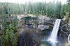 At least one feature in the Mount Cayley volcanic field is protected as a provincial park
. Brandywine Falls Provincial Park
at the southeastern end of the field was established to protect Brandywine Falls, a 70 m (229.7 ft) high waterfall on Brandywine Creek. It is composed of at least four lava flows of the Cheakamus Valley basalts. They are exposed in cliffs compassing the falls with a narrow sequence of gravel lying above the oldest lava unit. These lava flows are interpreted to have been exposed by erosion during a period of catastrophic flooding and the valley these lavas are located in is significantly larger than the river within it. The massive flooding that shaped the valley has been a subject of geological studies by Catherine Hickson
and Andree Blais-Stevens. It has been proposed that there could have been significant floods during the waning stages of the last glacial period as drainage in a valley further north was blocked with remnants of glacial ice. Another possible explanation is subglacial eruptions created large amounts of glacial meltwater that scoured the surface of the exposed lava flows.
Like other volcanic zones in the Garibaldi Belt, volcanoes in the Mount Cayley field are not monitored closely enough by the Geological Survey of Canada to ascertain how active their magma systems are. This is partly because the field is located in a remote region and no major eruptions have occurred in Canada in the past few hundred years. As a result, volcano monitoring is less important than dealing with other natural processes, including tsunami
s, earthquakes and landslides. However, with the existence of earthquakes, further volcanism is expected and would probably have considerable effects, particularly in a region like southwestern British Columbia where the Garibaldi Belt is located in a highly populated area. Because of these concerns, significant support from Canadian university scientists have resulted in the construction of a baseline of knowledge on the state of the Garibaldi volcanoes. This improvement is continuous and will support the understanding to monitor volcanoes in the Mount Cayley field for future volcanism.
on the northern flank of the upper Bridge River
. These areas are adjacent to Canada's populated southwest corner where the population of British Columbia is the greatest.
A large volcanic eruption from any volcanoes in the Mount Cayley field would have major effects on the Sea-to-Sky Highway and municipalities such as Squamish
, Whistler, Pemberton and probably Vancouver. Because of these concerns, the Geological Survey of Canada is planning to create hazard map
s and emergency plans for Mount Cayley, as well as Mount Meager
north of the volcanic field, which experienced a major volcanic eruption 2,350 years ago similar to the 1980 eruption of Mount St. Helens
.
for a long period of time. Evans (1990) has indicated that a number of landslides and debris flow
s at Mount Cayley in the past 10,000 years might have been caused by volcanic activity. Since the large debris avalanche 4,800 years ago, a number of more minor landslides have occurred at it, including one 1,100 years ago and another event 500 years ago. Both landslides ultimately blocked the Squamish River and created lakes upstream that lasted for a limited amount of time. In 1968 and 1983, a series of landslides took place that caused considerable damage to logging roads and forest stands, but did not result in any casualties. Future landslides from Mount Cayley and potential damming of the Squamish River are significant geological hazards to the general public, as well as to the economic development in the Squamish valley.
. The extent of earthquakes and the local seismographs in this region would warn the Geological Survey of Canada and possibly cause an upgrade in monitoring. While molten rock breaks through the crust, the size of the volcano vulnerable to an eruption would probably swell and the area would rupture, creating much more hydrothermal activity at the regional hot springs and the formation of new springs or fumarole
s. Small and probably significant rock avalanches may result and could dam the nearby Squamish River for a limited amount of time, such as those that occurred in the past without seismic activity and deformation related to magmatic activity. At some point the subsurface magma will produce phreatic eruption
s and lahar
s. At this time Highway 99 would be out of service and the residents of Squamish would have to travel away from the eruptive zone.
While molten rock comes closer to the surface it would most likely cause more fragmentation, triggering an explosive eruption that could produce an eruption column with an elevation of 20 km (12.4 mi) and may be sustained for 12 hours. A well-documented explosive eruption in the Garibaldi Belt with such force is the eruption of Mount Meager 2,350 years ago, which deposed ash as far east as Alberta
. This would endanger air traffic and would have to take another route away from the eruptive zone. Every airport buried under pyroclastic fall
would be out of service, including those in Vancouver, Victoria
, Kamloops, Prince George
and Seattle. The tephra would destroy power transmission lines, satellite dish
es, computers and other equipment that operates on electricity. Therefore, telephones, radios and cell phones would be disconnected. Structures not built for holding heavy material would likely demolish under the weight of the tephra. Ash from the eruption plume would subside above the vent area to create pyroclastic flows and would travel east and west down the nearby Cheakamus
and Squamish river valleys. These would likely have significant impacts on salmon in the associated rivers and would cause considerable melting of glacial ice to produce debris flows that may extend into Daisy Lake and Squamish to cause significant damage. The eruption column would then travel eastward and extract air travel throughout Canada from Alberta to Newfoundland and Labrador
.
Explosive eruptions may decrease and be followed by the eruption of viscous lava to form a lava dome in the newly formed crater. Precipitation
would frequently trigger lahars and these would continuously create problems in the Squamish and Cheakamus river valleys. If the lava dome continues to grow, it would eventually rise above the crater rim. The lava would be cooling and expanding then may produce landslides to create a massive zone of blocky talus in the Squamish river valley. While the dome of lava grows, it would frequently subside to create large pyroclastic flows that would again travel down the adjacent Squamish and Cheakamus river valleys. Tephra swept away from the pyroclastic flows would create ash columns with elevations of at least 10 km (6.2 mi), repeatedly depositing tephra on the communities of Whistler and Pemberton and again disrupting regional air crafts. Lava of the unstable dome may occasionally create minor pyroclastic flows, explosions and eruption columns. The community of Squamish would be abandoned, Highway 99 would be out of service and destroyed, and traffic adjacent to Vancouver, Pemberton and Whistler would remain forced to travel along a route to the east that is more lengthy than Highway 99.
Eruptions would likely continue for a period of time, followed by years of decreasing secondary activity. The solidifying lava would occasionally collapse portions of the volcano to create pyroclastic flows. Rubble on the flanks of the volcano and in valleys would occasionally be released to form debris flows. Major construction would be needed to repair the community of Squamish and Highway 99.
British Columbia Coast
The British Columbia Coast or BC Coast is Canada's western continental coastline on the Pacific Ocean. The usage is synonymous with the term West Coast of Canada....
of British Columbia
British Columbia
British Columbia is the westernmost of Canada's provinces and is known for its natural beauty, as reflected in its Latin motto, Splendor sine occasu . Its name was chosen by Queen Victoria in 1858...
, Canada
Canada
Canada is a North American country consisting of ten provinces and three territories. Located in the northern part of the continent, it extends from the Atlantic Ocean in the east to the Pacific Ocean in the west, and northward into the Arctic Ocean...
, stretching 31 km (19.3 mi) from the Pemberton Icefield
Pemberton Icefield
The Pemberton Icefield, also known unofficially as the Pemberton Icecap, is the southernmost of the series of very large icefields studding the Pacific Ranges of the southern Coast Mountains in British Columbia, Canada...
to the Squamish River
Squamish River
The Squamish River is a short but very large river in the Canadian province of British Columbia. Its drainage basin is in size. The total length of the Squamish River is approximately .-Course:...
. It forms a segment of the Garibaldi Volcanic Belt
Garibaldi Volcanic Belt
The Garibaldi Volcanic Belt, also called the Canadian Cascade Arc, is a northwest-southeast trending volcanic chain in the Pacific Ranges of the Coast Mountains that extends from Watts Point in the south to the Ha-Iltzuk Icefield in the north. This chain of volcanoes is located in southwestern...
, the Canadian portion of the Cascade Volcanic Arc
Cascade Volcanoes
The Cascade Volcanoes are a number of volcanoes in a volcanic arc in western North America, extending from southwestern British Columbia through Washington and Oregon to Northern California, a distance of well over 700 mi ...
, which extends from Northern California
Northern California
Northern California is the northern portion of the U.S. state of California. The San Francisco Bay Area , and Sacramento as well as its metropolitan area are the main population centers...
to southwestern British Columbia. Most of the Cayley volcanoes were formed during periods of volcanism
Volcanism
Volcanism is the phenomenon connected with volcanoes and volcanic activity. It includes all phenomena resulting from and causing magma within the crust or mantle of a planet to rise through the crust and form volcanic rocks on the surface....
under sheets of glacial ice throughout the last glacial period. These subglacial eruption
Subglacial eruption
A subglacial eruption is a volcanic eruption that has occurred under ice, or under a glacier. Subglacial eruptions can cause dangerous floods, lahars and create hyaloclastite and pillow lava. Subglacial eruptions sometimes form a subglacial volcano called a tuya. Tuyas in Iceland are called table...
s formed steep, flat-topped volcanoes
Tuya
A tuya is a type of distinctive, flat-topped, steep-sided volcano formed when lava erupts through a thick glacier or ice sheet. They are somewhat rare worldwide, being confined to regions which were covered by glaciers and also had active volcanism during the same time period.-Formation:Tuyas are...
and subglacial lava dome
Lava dome
|250px|thumb|right|Image of the [[rhyolitic]] lava dome of [[Chaitén Volcano]] during its 2008–2009 eruption.In volcanology, a lava dome is a roughly circular mound-shaped protrusion resulting from the slow extrusion of viscous lava from a volcano...
s, most of which have been entirely exposed by deglaciation. However, at least two volcanoes predate the last glacial period and both are highly eroded. The field gets its name from Mount Cayley
Mount Cayley
Mount Cayley is a potentially active stratovolcano in Squamish-Lillooet Regional District of southwestern British Columbia, Canada. Located north of Squamish and west of Whistler in the Pacific Ranges of the Coast Mountains, it rises above the Squamish River to the west and above the Cheakamus...
, the largest and most persistent volcano, located at the southern end of the Powder Mountain Icefield
Powder Mountain Icefield
The Powder Mountain Icefield, also called the Powder Mountain Icecap and the Cayley Icefield, is a glacial field in the Pacific Ranges of southwestern British Columbia, Canada, about west of Whistler and about north of Vancouver...
. This icefield covers much of the central portion of the volcanic field
Volcanic field
A volcanic field is an area of the Earth's crust that is prone to localized volcanic activity. They usually contain 10 to 100 volcanoes, such as cinder cones and are usually in clusters. Lava flows may also occur...
and is one of the several glacial fields in the Pacific Ranges
Pacific Ranges
The Pacific Ranges are the southernmost subdivision of the Coast Mountains portion of the Pacific Cordillera. Located entirely within British Columbia, Canada, they run northwest from the lower stretches of the Fraser River to Bella Coola, north of which are the Kitimat Ranges.The Pacific Ranges...
of the Coast Mountains
Coast Mountains
The Coast Mountains are a major mountain range, in the Pacific Coast Ranges, of western North America, extending from southwestern Yukon through the Alaska Panhandle and virtually all of the Coast of British Columbia. They are so-named because of their proximity to the sea coast, and are often...
.
Eruptions along the length of the field began between 1.6 and 5.3 million years ago. At least 23 eruptions have occurred throughout its eruptive history. This volcanic activity ranged from effusive
Effusive eruption
An effusive eruption is a volcanic eruption characterized by the outpouring of lava onto the ground...
to explosive
Explosive eruption
An explosive eruption is a volcanic term to describe a violent, explosive type of eruption. Mount St. Helens in 1980 was an example. Such an eruption is driven by gas accumulating under great pressure. Driven by hot rising magma, it interacts with ground water until the pressure increases to the...
, with magma compositions ranging from basalt
Basalt
Basalt is a common extrusive volcanic rock. It is usually grey to black and fine-grained due to rapid cooling of lava at the surface of a planet. It may be porphyritic containing larger crystals in a fine matrix, or vesicular, or frothy scoria. Unweathered basalt is black or grey...
ic to rhyolitic
Rhyolite
This page is about a volcanic rock. For the ghost town see Rhyolite, Nevada, and for the satellite system, see Rhyolite/Aquacade.Rhyolite is an igneous, volcanic rock, of felsic composition . It may have any texture from glassy to aphanitic to porphyritic...
. Because the Mount Cayley volcanic field has a high elevation
Elevation
The elevation of a geographic location is its height above a fixed reference point, most commonly a reference geoid, a mathematical model of the Earth's sea level as an equipotential gravitational surface ....
and consists of a cluster of mostly high altitude, non-overlapping volcanoes, subglacial activity is likely to have occurred under less than 800 m (2,624.7 ft) of glacial ice. The style of this glaciation promoted meltwater
Meltwater
Meltwater is the water released by the melting of snow or ice, including glacial ice and ice shelfs over oceans. Meltwater is often found in the ablation zone of glaciers, where the rate of snow cover is reducing...
escape during eruptions. The steep profile of the volcanic field and its subglacial landforms support this hypothesis. As a result, volcanic features in the field that interacted with glacial ice lack rocks that display evidence of abundant water during eruption, such as hyaloclastite
Hyaloclastite
Hyaloclastite is a hydrated tuff-like breccia rich in black volcanic glass, formed during volcanic eruptions under water, under ice or where subaerial flows reach the sea or other bodies of water. It has the appearance of angular flat fragments sized between a millimeter to few centimeters...
and pillow lava
Pillow lava
Pillow lavas are lavas that contain characteristic pillow-shaped structures that are attributed to the extrusion of the lava under water, or subaqueous extrusion. Pillow lavas in volcanic rock are characterized by thick sequences of discontinuous pillow-shaped masses, commonly up to one metre in...
.
Of the entire volcanic field, the southern portion has the most known volcanoes. Here, at least 11 of them are situated on top of a long narrow mountain ridge and in adjacent river valley
River Valley
River Valley is the name of an urban planning area within the Central Area, Singapore's central business district.The River Valley Planning Area is defined by the region bounded by Orchard Boulevard, Devonshire Road and Eber Road to the north, Oxley Rise and Mohamed Sultan Road to the east, Martin...
s. The central portion contains at least five volcanoes situated at the Powder Mountain Icefield. To the north, two volcanoes form a sparse area of volcanism. Many of these volcanoes were formed between 0.01 and 1.6 million years ago, some of which show evidence of volcanic activity in the past 10,000 years.
Formation
Subduction
In geology, subduction is the process that takes place at convergent boundaries by which one tectonic plate moves under another tectonic plate, sinking into the Earth's mantle, as the plates converge. These 3D regions of mantle downwellings are known as "Subduction Zones"...
of the Juan de Fuca Plate
Juan de Fuca Plate
The Juan de Fuca Plate, named after the explorer of the same name, is a tectonic plate, generated from the Juan de Fuca Ridge, and subducting under the northerly portion of the western side of the North American Plate at the Cascadia subduction zone...
under the North American Plate
North American Plate
The North American Plate is a tectonic plate covering most of North America, Greenland, Cuba, Bahamas, and parts of Siberia, Japan and Iceland. It extends eastward to the Mid-Atlantic Ridge and westward to the Chersky Range in eastern Siberia. The plate includes both continental and oceanic crust...
at the Cascadia subduction zone along the British Columbia Coast. This is a 1094 km (679.8 mi) long fault zone running 80 km (49.7 mi) off the Pacific Northwest
Pacific Northwest
The Pacific Northwest is a region in northwestern North America, bounded by the Pacific Ocean to the west and, loosely, by the Rocky Mountains on the east. Definitions of the region vary and there is no commonly agreed upon boundary, even among Pacific Northwesterners. A common concept of the...
from Northern California
Northern California
Northern California is the northern portion of the U.S. state of California. The San Francisco Bay Area , and Sacramento as well as its metropolitan area are the main population centers...
to southwestern British Columbia. The plates move at a relative rate of over 10 mm (0.393700787401575 in) per year at an oblique angle to the subduction zone. Because of the very large fault area, the Cascadia subduction zone can produce large earthquake
Earthquake
An earthquake is the result of a sudden release of energy in the Earth's crust that creates seismic waves. The seismicity, seismism or seismic activity of an area refers to the frequency, type and size of earthquakes experienced over a period of time...
s of magnitude
Magnitude (mathematics)
The magnitude of an object in mathematics is its size: a property by which it can be compared as larger or smaller than other objects of the same kind; in technical terms, an ordering of the class of objects to which it belongs....
7.0 or greater. The interface between the Juan de Fuca and North American plates remains locked for periods of roughly 500 years. During these periods, stress builds up on the interface between the plates and causes uplift of the North American margin. When the plate finally slips, the 500 years of stored energy are released in a massive earthquake.
Unlike most subduction zones worldwide, there is no deep oceanic trench
Oceanic trench
The oceanic trenches are hemispheric-scale long but narrow topographic depressions of the sea floor. They are also the deepest parts of the ocean floor....
present along the continental margin
Continental margin
The continental margin is the zone of the ocean floor that separates the thin oceanic crust from thick continental crust. Continental margins constitute about 28% of the oceanic area....
in Cascadia. The reason is that the mouth of the Columbia River
Columbia River
The Columbia River is the largest river in the Pacific Northwest region of North America. The river rises in the Rocky Mountains of British Columbia, Canada, flows northwest and then south into the U.S. state of Washington, then turns west to form most of the border between Washington and the state...
empties directly into the subduction zone and deposits silt at the bottom of the Pacific Ocean
Pacific Ocean
The Pacific Ocean is the largest of the Earth's oceanic divisions. It extends from the Arctic in the north to the Southern Ocean in the south, bounded by Asia and Australia in the west, and the Americas in the east.At 165.2 million square kilometres in area, this largest division of the World...
, burying the oceanic trench. Massive floods from prehistoric Glacial Lake Missoula
Glacial Lake Missoula
Glacial Lake Missoula was a prehistoric proglacial lake in western Montana that existed periodically at the end of the last ice age between 15,000 and 13,000 years ago...
during the Late Pleistocene
Late Pleistocene
The Late Pleistocene is a stage of the Pleistocene Epoch. The beginning of the stage is defined by the base of the Eemian interglacial phase before the final glacial episode of the Pleistocene 126,000 ± 5,000 years ago. The end of the stage is defined exactly at 10,000 Carbon-14 years BP...
also deposited large amounts of sediment
Sediment
Sediment is naturally occurring material that is broken down by processes of weathering and erosion, and is subsequently transported by the action of fluids such as wind, water, or ice, and/or by the force of gravity acting on the particle itself....
into the trench. However, in common with other subduction zones, the outer margin is slowly being compressed, similar to a giant spring. When the stored energy is suddenly released by slippage across the fault at irregular intervals, the Cascadia subduction zone can create very large earthquakes, such as the magnitude 9.0 Cascadia earthquake on January 26, 1700. However, earthquakes along the Cascadia subduction zone are fewer than expected and there is evidence of a decline in volcanic activity over the past few million years. The probable explanation lies in the rate of convergence between the Juan de Fuca and North American plates. These two tectonic plates currently converge 3 cm (1.2 in) to 4 cm (1.6 in) per year. This is only about half the rate of convergence from seven million years ago.
Scientists have estimated that there have been at least 13 significant earthquakes along the Cascadia subduction zone in the past 6,000 years. The most recent, the 1700 Cascadia earthquake, was recorded in the oral traditions of the First Nations
First Nations
First Nations is a term that collectively refers to various Aboriginal peoples in Canada who are neither Inuit nor Métis. There are currently over 630 recognised First Nations governments or bands spread across Canada, roughly half of which are in the provinces of Ontario and British Columbia. The...
people on Vancouver Island
Vancouver Island
Vancouver Island is a large island in British Columbia, Canada. It is one of several North American locations named after George Vancouver, the British Royal Navy officer who explored the Pacific Northwest coast of North America between 1791 and 1794...
. It caused considerable tremors and a massive tsunami
Tsunami
A tsunami is a series of water waves caused by the displacement of a large volume of a body of water, typically an ocean or a large lake...
that traveled across the Pacific Ocean. The significant shaking associated with this earthquake demolished houses of the Cowichan Tribes
Cowichan Tribes
The Cowichan Tribes First Nations government, located in and around the Cowichan Valley and Duncan, British Columbia, it is the single largest band government in British Columbia....
on Vancouver Island and caused several landslide
Landslide
A landslide or landslip is a geological phenomenon which includes a wide range of ground movement, such as rockfalls, deep failure of slopes and shallow debris flows, which can occur in offshore, coastal and onshore environments...
s. Shaking due to this earthquake made it too difficult for the Cowichan people to stand, and the tremors were so lengthy that they were sickened. The tsunami created by the earthquake ultimately devastated a winter village at Pachena Bay, killing all the people that lived there. The 1700 Cascadia earthquake caused near-shore subsidence, submerging marsh
Marsh
In geography, a marsh, or morass, is a type of wetland that is subject to frequent or continuous flood. Typically the water is shallow and features grasses, rushes, reeds, typhas, sedges, other herbaceous plants, and moss....
es and forests on the coast that were later buried under more recent debris.
Subglacial volcanoes
Lying in the middle of the Mount Cayley volcanic field is a subglacial volcano named Slag HillSlag Hill
Slag Hill is a subglacial volcano associated with the Mount Cayley volcanic field in British Columbia, Canada. It consists of glassy, augite-phyric basaltic andesite in steep-sided, glassy, finely jointed domes and one small, flat-topped bluff. The finely jointed domes are similar to those of Ember...
. At least two geological units compose the edifice. Slag Hill proper consists of andesite
Andesite
Andesite is an extrusive igneous, volcanic rock, of intermediate composition, with aphanitic to porphyritic texture. In a general sense, it is the intermediate type between basalt and dacite. The mineral assemblage is typically dominated by plagioclase plus pyroxene and/or hornblende. Magnetite,...
lava flows and small amounts of pyroclastic rock
Pyroclastic rock
Pyroclastic rocks or pyroclastics are clastic rocks composed solely or primarily of volcanic materials. Where the volcanic material has been transported and reworked through mechanical action, such as by wind or water, these rocks are termed volcaniclastic...
. Lying on the western portion of Slag Hill is a lava flow that likely erupted less than 10,000 years ago due to the lack of features indicating volcano-ice interactions. The Slag Hill flow-dominated tuya 900 m (2,952.8 ft) northeast of Slag Hill proper consists of a flat-topped, steep-sided pile of andesite. It protrudes through remnants of volcanic material erupted from Slag Hill proper, but it represents a separate volcanic vent due to its geographical appearance. This small subglacial volcano possibly formed between 25,000 and 10,000 years ago throughout the waning stages of the Fraser Glaciation.
Cauldron Dome
Cauldron Dome
Cauldron Dome is a tuya in the Mount Cayley volcanic field, British Columbia, Canada. Cauldron Dome is made of coarsely plagioclase-orthophyroxene-phyric andesite lava flows and last erupted during the Holocene...
, a subglacial volcano north of Mount Cayley, lies west of the Powder Mountain Icefield. Like Slag Hill, it is composed of two geological units. Upper Cauldron Dome is a flat-topped, oval-shaped pile of at least five andesite lava flows that resembles a tuya. The five andesite flows are columnar jointed and were likely extruded through glacial ice. The latest volcanic activity might have occurred between 10,000 and 25,000 years ago when this area was still influenced by glacial ice of the Fraser Glaciation. Lower Cauldron Dome, the youngest unit comprising the entire Cauldron Dome subglacial volcano, consists of a flat-topped, steep-sided pile of andesite lava flows 1800 m (5,905.5 ft) long and a maximum thickness of 220 m (721.8 ft). These volcanics were extruded about 10,000 years ago during the waning stages of the Fraser Glaciation from a vent adjacent to upper Cauldron Dome that is currently buried under glacial ice.
To the north lies Little Ring Mountain, another flow-dominated tuya lying at the northern portion of the Mount Cayley volcanic field. It consists of a pile of at least three andesite lava flows lying on a mountain ridge. Its steep-sided flanks reach heights of 240 m (787.4 ft) and are composed of volcanic rubble. This makes it impossible to measure its exact base elevation or how many lava flows comprise the edifice. With a summit elevation of 2147 m (7,044 ft), Little Ring Mountain had its last volcanic activity between 25,000 and 10,000 years ago when the Fraser Glaciation was close to its maximum.
Ember Ridge
Ember Ridge
Ember Ridge is a volcanic mountain ridge associated with the Mount Cayley volcanic field in British Columbia, Canada. Ember Ridge is made of a series of steep-sided domes of glassy, complexly jointed, hornblende-phyric basalt with the most recent eruptions during the Holocene...
, a mountain ridge between Tricouni Peak
Tricouni Peak
Tricouni Peak is a mountain located south of Cypress Peak on the Squamish-Cheakamus divide within the Pacific Ranges of the Coast Mountains in southwestern British Columbia, Canada. It was named by Tom Fyles during its first ascent party in 1931 due to its appearance of a 3-pointed tricouni boot nail...
and Mount Fee, consists of at least eight lava domes composed of andesite. They were likely formed between 25,000 and 10,000 years ago when lava erupted beneath glacial ice of the Fraser Glaciation. Their current structures are comparable to their original forms due to the minimal degree of erosion. As a result, the domes display the shapes and columnar joints typical of subglacial volcanoes. The random shapes of the Ember Ridge domes are the result of erupted lava taking advantage of former ice pockets, eruptions taking place on uneven surfaces, subsidence of the domes during volcanic activity to create rubble and separation of older columnar units during more recent eruptions. The northern dome, known as Ember Ridge North, covers the summit and eastern flank of the mountain ridge. It comprises at least one lava flow that reaches a thickness of 100 m (328.1 ft), as well as the thinnest columnar units in the Mount Cayley volcanic field. The small size of the columnar joints indicates that the erupted lava was cooled immediately and are mainly located on the dome's summit. Ember Ridge Northeast, the smallest subglacial dome of Ember Ridge, comprises one lava flow that has a thickness no more than 40 m (131.2 ft). Ember Ridge Northwest, the most roughly circular subglacial dome, comprises at least one lava flow. Ember Ridge Southeast is the most complex of the Ember Ridge domes, consisting of a series of lava flows with a thickness of 60 m (196.9 ft). It is also the only Ember Ridge dome that contains large amounts of rubble. Ember Ridge Southwest comprises at least one lava flow that reaches a thickness of 80 m (262.5 ft). It is the only subglacial dome of Ember Ridge that contains hyaloclastite. Ember Ridge West comprises only one lava flow that reaches a thickness of 60 m (196.9 ft).
Mount Brew
Mount Brew (Cheakamus River)
Mount Brew is a rounded mountain in southwestern British Columbia, Canada, located southwest of Whistler in the Pacific Ranges of the Coast Mountains. A public cabin run by the Varsity Outdoor Club, Brew Hut, is located near the summit...
, 18 km (11.2 mi) southwest of the resort town
Resort town
A resort town, sometimes called a resort city or resort destination, is a town or area where tourism or vacationing is a primary component of the local culture and economy...
of Whistler
Whistler, British Columbia
Whistler is a Canadian resort town in the southern Pacific Ranges of the Coast Mountains in the province of British Columbia, Canada, approximately north of Vancouver...
, is a 1757 m (5,764.4 ft) high lava dome composed of andesite or dacite that probably formed subglacially between 25,000 and 10,000 years ago. It contains two masses of rock that might resemble ice-marginal lava flows. These edifices have not been studied in detail but they could have formed during the same period as the Ember Ridge subglacial domes due to their structures, columnar joints and compositions.
Eroded edifices
Massif
In geology, a massif is a section of a planet's crust that is demarcated by faults or flexures. In the movement of the crust, a massif tends to retain its internal structure while being displaced as a whole...
, 2385 m (7,824.8 ft) in elevation, is the largest and most persistent volcano in the Mount Cayley volcanic field. It is a highly eroded stratovolcano composed of dacite and rhyodacite
Rhyodacite
Rhyodacite is an extrusive volcanic rock intermediate in composition between dacite and rhyolite. It is the extrusive equivalent of granodiorite. Phenocrysts of sodium rich plagioclase, sanidine, quartz, and biotite or hornblende are typically set in an aphanitic to glassy light to intermediate...
lava that was deposited during three phases of volcanic activity. The first eruptive phase started about four million years ago with the eruption of dacite lava flows and pyroclastic rock. This resulted in the creation of the Mount Cayley proper. Subsequent volcanism during this volcanic phase constructed a significant lava dome. This acts like a volcanic plug and composes the lava spine
Lava spine
A lava spine is a vertically growing monolith of viscous lava that is slowly forced from a volcanic vent, such as those growing on a lava dome . It may also be considered a kind of dome called a spiny dome . In February of 1983, the dome activity of Mount St...
s that currently form pinnacles on Cayley's rugged summit. After the Mount Cayley proper was constructed, lava flows, tephra
Tephra
200px|thumb|right|Tephra horizons in south-central [[Iceland]]. The thick and light coloured layer at center of the photo is [[rhyolitic]] tephra from [[Hekla]]....
and welded dacite rubble was erupted. This second phase of activity million years ago resulted in the creation of the Vulcan's Thumb
Vulcan's Thumb
Vulcan's Thumb is a deeply dissected, unstable stratovolcano located directly on the southern ridge of Pyroclastic Peak. It is one of the five main volcanic peaks of the Mount Cayley massif and remains unclimbed because of technical difficulties and its loose rock...
, a craggy volcanic ridge on the southern flank of the Mount Cayley proper. Lengthy dissection from an extended period of erosion demolished much of the original stratovolcano. Volcanic activity after this prolonged period of erosion produced thick dacite lava flows from parasitic vents 300,000 years ago that extended into the Turbid
Turbid Creek
Turbid Creek is a creek in southwestern British Columbia, Canada flowing southwest into the Squamish River....
and Shovelnose Creek
Shovelnose Creek
Shovelnose Creek is a creek in the Pacific Ranges of the Coast Mountains in southwestern British Columbia, Canada. It flows southwest into the Squamish River and south of the Elaho River....
valleys near the Squamish River. This subsequently created two minor parasitic lava domes 200,000 years ago. These three volcanic events in contrast to several others around Cayley in that they do not show signs of interaction with glacial ice.
Immediately southeast of Mount Cayley lies Mount Fee
Mount Fee
Mount Fee is a volcanic peak in the Pacific Ranges of the Coast Mountains in southwestern British Columbia, Canada. It is located south of Callaghan Lake and west of the resort town of Whistler. With a summit elevation of and a topographic prominence of , it rises above the surrounding rugged...
, an extensively eroded volcano containing a north-south trending ridge. It has an elevation of 2162 m (7,093.2 ft) and is one of the older volcanic features in the Mount Cayley volcanic field. Its volcanics are undated, but its large amount of dissection and evidence of glacial ice overriding the volcano indicates that it formed more than 75,000 years ago before the Wisconsinan Glaciation
Wisconsinan glaciation
The Wisconsin Glacial Episode was the most recent major advance of the North American Laurentide ice sheet. Globally, this advance is known as the last glacial period. The Wisconsin glaciation extended from approximately 110,000 to 10,000 years ago, between the Eemian interglacial and the current...
. Therefore, volcanism at Mount Fee does not display evidence of interaction with glacial ice. The remaining products from Fee's earliest volcanic activity is a minor portion of pyroclastic rock. This is evidence of explosive volcanism from Fee's eruptive history, as well as its first volcanic event. The second volcanic event produced a sequence of lavas and breccias on the eastern flank of the main ridge. These volcanics were likely deposited when a sequence of lava flows and broken lava fragments erupted from a volcanic vent and moved down the flanks during the construction of a large volcano. Following extensive dissection, renewed volcanism produced a viscous series of lava flows forming its narrow, flat-topped, steep-sided northern limit and the northern end of the main ridge. The conduit for which these lava flows originated from was likely vertical in structure and intruded through older volcanics deposited during Fee's earlier volcanic events. This volcanic event was also followed by a period of erosion, and likely one or more glacial periods. Extensive erosion following the last volcanic event at Mount Fee has created the rugged north-south trending ridge that currently forms a prominent landmark.
Pali Dome
Pali Dome
Pali Dome is the unofficial name for a volcanic peak in the Pacific Ranges of the Coast Mountains in southwestern British Columbia, Canada.-See also:*List of volcanoes in Canada*Mount Cayley volcanic field*Volcanism of Canada*Volcanism of Western Canada...
, located north and northeast of Mount Cayley, is an eroded volcano in the central Mount Cayley volcanic field. Like Cauldron Dome, it consists of two geological units. Pail Dome East is composed of a mass of andesite lava flows and small amounts of pyroclastic material. It lies on the eastern portion of the Powder Mountain Icefield. Much of the lava flows form gentle topography at high elevations but terminate in finely jointed vertical cliffs at low elevations. The first volcanic activity likely occurred about 25,000 years ago, but it could also be significantly older. The most recent volcanic activity produced a series of lava flows that were erupted when the vent area was not covered by glacial ice. However, the flows show evidence of interaction with glacial ice in their lower units. This indicates that the lavas were erupted about 10,000 years ago during the waning stages of the Fraser Glaciation. The ice-marginal lava flows reach thicknesses of up to 100 m (328.1 ft). Pali Dome West consists of at least three andesite lava flows and small amounts of pyroclastic material; its vent presently buried under glacial ice. At least three eruptions have occurred at Pali Dome East. The age of the first volcanic eruption is unknown, but it could have occurred in the past 10,000 years. The second eruption produced a lava flow that was erupted when the vent area was not buried under glacial ice. However, the flow does show evidence of interaction with glacial ice at its lower unit. This indicates that the lavas were erupted during the waning stages of the Fraser Glaciation. The third and most recent eruption produced another lava flow that was largely erupted above glacial ice, but was probably constrained on its northern margin by a small glacier. Unlike the lava flow that was erupted during the second eruption, this lava flow was not impounded by glacial ice at its lower unit. This suggests that it erupted less than 10,000 years ago when the regional Fraser Glaciation retreated.
Lava flows
At least two sequences of basaltic andesiteBasaltic andesite
Basaltic andesite is a black volcanic rock containing about 55% silica. Minerals in basaltic andesite include olivine, augite and plagioclase. Basaltic andesite can be found in volcanoes around the world, including in Central America and the Andes of South America. Basaltic andesite is common in...
lava flows are deposited south of Tricouni Peak
Tricouni Peak
Tricouni Peak is a mountain located south of Cypress Peak on the Squamish-Cheakamus divide within the Pacific Ranges of the Coast Mountains in southwestern British Columbia, Canada. It was named by Tom Fyles during its first ascent party in 1931 due to its appearance of a 3-pointed tricouni boot nail...
. One of these sequences, known as Tricouni Southwest
Tricouni Southwest
Tricouni Southwest is a term for a basaltic andesite lava flow in the Mount Cayley volcanic field of the Garibaldi Volcanic Belt in southwestern British Columbia, Canada, located south of Tricouni Peak.-See also:*Volcanism of Canada...
, creates a cliff on the eastern side of a north-south trending channel with a depth of 200 m (656.2 ft) adjacent to the High Falls Creek
High Falls Creek
High Falls Creek is a creek in southwestern British Columbia, Canada, located in the New Westminster Land District. It flows southwest into the larger Squamish River....
mouth. The eastern flank of the lava flow, outside the High Falls Creek channel, has a more constant structure. Several fine-scale columnar joints and the overall structure of the lava flow suggest that its western portion, along the length of the channel, ponded against glacial ice. Near its southern unit, lava oozed into cracks in the glacial ice. This has been identified by the existence of spire-like cooling formations, although many of these edifices have been destroyed by erosional processes. Other features that indicate the lava ponded against glacial ice include its unusually thick structure and its steep cliffs. Therefore, the Tricouni Southwest lava flow was erupted about 10,000 years ago when the regional Fraser Glaciation was retreating. The explanation for the western portion displaying ice-contact features while the eastern portion does not is likely because its western flank lies in a north-south trending channel, which would have been able to maintain smaller amounts of solar heat than its unsheltered eastern flank. As a result, the western portion of the lava flow records glaciation during a period when the eastern slopes were free from glacial ice.
Tricouni Southeast, another volcanic sequence south of Tricouni Peak, consists of at least four andesite or dacite lava flows that outcrop as several small cliffs and bluffs on extensively vegetated flanks. They reach thicknesses of 100 m (328.1 ft) and contain small amounts of hyaloclastite. The feeder of their origins has not been discovered but is likely located at the summit of the mound. These lavas form ice-marginal edifies, suggesting that every lava flow was erupted about 10,000 years ago when the vast Cordilleran Ice Sheet was retreating and remains of glacial ice was sparse.
Exposed along the Cheakamus River
Cheakamus River
The Cheakamus River is a tributary of the Squamish River, beginning on the west slopes of Outlier Peak in Garibaldi Provincial Park upstream from Cheakamus Lake on the southeastern outskirts of the resort area of Whistler. The river flows into Cheakamus Lake before exiting it and flowing...
and its tributaries
Tributary
A tributary or affluent is a stream or river that flows into a main stem river or a lake. A tributary does not flow directly into a sea or ocean...
are the Cheakamus Valley basalts
Cheakamus Valley basalts
The Cheakamus Valley basalts are a sequence of basaltic lava flows at the Cheakamus River in southwestern British Columbia, Canada. They are part of the Garibaldi section of the Cascade Volcanic Arc and were produced during an episode of volcanic eruptions from an unknown vent...
. Although not necessarily mapped as part of the Cayley field, this sequence of basaltic lava flows is geologically similar and comparable in age to volcanic features that are part of this volcanic field. At least four basaltic flows comprise the sequence and were deposited during periods of volcanic activity from an unknown vent between 0.01 and 1.6 million years ago. Pillow lava is abundant along the bases the flows, some of which are underlain by hyaloclastite breccia. In 1958, Canadian volcanologist Bill Mathews
Bill Mathews
William Henry Mathews was a Canadian geologist, volcanologist, engineer, and professor. He is considered a pioneer in the study of subglacial eruptions and volcano-ice interactions in North America...
suggested that the lava flows were erupted during periods of subglacial activity and traveled through trenches or tunnels melted in glacial ice of the Fraser Glaciation. Mathews based this on the age of the underlying till, the existence of pillow lava close to the bottom of some lavas, indicating subaqueous volcanism, the columnar jointing at the edges of the lavas, indicating rapid cooling, and the absence of apparent palaeogeography
Palaeogeography
Palaeogeography is the study of what the geography was in times past. It is most often used about the physical landscape, although nothing excludes its use in reference to the human or cultural environment...
.
Petrography
The andesite lava of Ember Ridge comprises 55% brownish-green volcanic glassVolcanic glass
Volcanic glass is the amorphous product of rapidly cooling magma. Like all types of glass, it is a state of matter intermediate between the close-packed, highly ordered array of a crystal and the highly disordered array of gas...
with a trachytic
Trachyte
Trachyte is an igneous volcanic rock with an aphanitic to porphyritic texture. The mineral assemblage consists of essential alkali feldspar; relatively minor plagioclase and quartz or a feldspathoid such as nepheline may also be present....
matrix
Matrix (geology)
The matrix or groundmass of rock is the finer grained mass of material in which larger grains, crystals or clasts are embedded.The matrix of an igneous rock consists of finer grained, often microscopic, crystals in which larger crystals are embedded. This porphyritic texture is indicative of...
of plagioclase
Plagioclase
Plagioclase is an important series of tectosilicate minerals within the feldspar family. Rather than referring to a particular mineral with a specific chemical composition, plagioclase is a solid solution series, more properly known as the plagioclase feldspar series...
. About 35% of Ember Ridge andesite contains phenocryst
Phenocryst
thumb|right|300px|[[Granite]]s often have large [[feldspar|feldspatic]] phenocrysts. This granite, from the [[Switzerland|Swiss]] side of the [[Mont Blanc]] massif, has large white [[plagioclase]] phenocrysts, [[triclinic]] [[mineral]]s that give [[trapezium|trapezoid]] shapes when cut through)...
s of hornblende
Hornblende
Hornblende is a complex inosilicate series of minerals .It is not a recognized mineral in its own right, but the name is used as a general or field term, to refer to a dark amphibole....
, augite
Augite
Augite is a single chain inosilicate mineral, 2O6. The crystals are monoclinic and prismatic. Augite has two prominent cleavages, meeting at angles near 90 degrees.-Characteristics:Augite is a solid solution in the pyroxene group...
, plagioclase and orthopyroxene and exist as isolated crystals and clots. A feature south of Ember Ridge, unofficially known as Betty's Bump, comprises andesite with phenocrysts of plagioclase, augite and olivine
Olivine
The mineral olivine is a magnesium iron silicate with the formula 2SiO4. It is a common mineral in the Earth's subsurface but weathers quickly on the surface....
. Dark brown volcanic glass composes the Betty's Bump andesite as much as 20%. The relationship of Betty's Bump with Ember Ridge is unclear but it likely represents a separate volcanic feature due to its topographic isolation.
Little Ring Mountain at the northern end of the field contains at least 70% brown volcanic glass with isolated phenocrysts of plagioclase. Vesicular texture
Vesicular texture
Vesicular texture is a volcanic rock texture characterised by a rock being pitted with many cavities at its surface and inside. The texture is often found in extrusive aphanitic, or glassy, igneous rock...
s are up to 5%, suggesting that the lava erupted subaerially
Subaerial eruption
A subaerial eruption is a volcanic eruption that has occurred on the surface. They generally produce pyroclastic flows, lava fountains, and lava flows, which are commonly classified in different subearial eruption types, including Plinian, Peléan, and Hawaiian eruptions. Subaerial eruptions...
. Probable xenocrysts of quartz
Quartz
Quartz is the second-most-abundant mineral in the Earth's continental crust, after feldspar. It is made up of a continuous framework of SiO4 silicon–oxygen tetrahedra, with each oxygen being shared between two tetrahedra, giving an overall formula SiO2. There are many different varieties of quartz,...
have been identified at the volcano. At least one xenolith
Xenolith
A xenolith is a rock fragment which becomes enveloped in a larger rock during the latter's development and hardening. In geology, the term xenolith is almost exclusively used to describe inclusions in igneous rock during magma emplacement and eruption...
fragment has been found in loose rubble at the volcano and included several quartz xenocrysts and polycrystalline quartz xenoliths in a glassy matrix with trachytic plagioclase.
The dacite volcanics composing Mount Fee contain brown volcanic glass as much as 70% and vesicular textures as much as 15%. About 25% of the volcanics contain crystal content, including plagioclase, hornblende, orthopyroxene, orthoclase
Orthoclase
Orthoclase is an important tectosilicate mineral which forms igneous rock. The name is from the Greek for "straight fracture," because its two cleavage planes are at right angles to each other. Alternate names are alkali feldspar and potassium feldspar...
and sporadic quartz. The orthoclase crystals are interpreted to represent rock fragments that became enveloped during hardening of the dacitic lavas. A portion of the southwestern flank of Mount Fee comprises no volcanic glass, but rather composed of an abnormal cryptocrystalline
Cryptocrystalline
Cryptocrystalline is a rock texture made up of such minute crystals that its crystalline nature is only vaguely revealed even microscopically in thin section by transmitted polarized light. Among the sedimentary rocks, chert and flint are cryptocrystalline. Carbonado, a form of diamond, is also...
matrix. This indicates that it might have developed as part of a subvolcanic
Subvolcanic rock
A subvolcanic rock, also known as a hypabyssal rock, is an igneous rock that originates at medium to shallow depths within the crust and contain intermediate grain size and often porphyritic texture. They have textures between volcanic and plutonic rocks. Subvolcanic rocks include diabase and...
intrusion.
At Ring Mountain, andesite comprises 70% brown volcanic glass and vesicular textures as much as 15%. The plagioclastic matrix is trachytic. Augite, biotite, plagioclase and hornblende occur as microphenocrysts and comprise 1% to 7% of the andesite. Small qualities of quartz are common and occur as microxenocrysts. Microxenocrysts of orthoclase likely exist in andesite at Ring Mountain.
Andesite at Slag Hill consists of 70% dark brown volcanic glass with varied degrees of trachytic texture in the plagioclastic matrix and less than 5% of the andesite comprises vesicular textures. Plagioclase, hornblende and augite are mostly in form as phenocrysts and comprise 1% to 10% of the andesite. Orthoclase crystals are found occasionally and they likely represent xenocrysts.
Geothermal and seismic activity
Natural Resources Canada
The Department of Natural Resources , operating under the FIP applied title Natural Resources Canada , is the ministry of the government of Canada responsible for natural resources, energy, minerals and metals, forests, earth sciences, mapping and remote sensing...
employess supported lithoprobe studies in the region of Mount Cayley that created a large reflector interpreted to be a pool of molten rock roughly 15 km (9.3 mi) below the surface. It is estimated to be 3 km (1.9 mi) long and 1 km (0.621372736649807 mi) wide with a thickness of less than 1.6 km (0.994196378639691 mi). The reflector is understood to be a sill
Sill (geology)
In geology, a sill is a tabular sheet intrusion that has intruded between older layers of sedimentary rock, beds of volcanic lava or tuff, or even along the direction of foliation in metamorphic rock. The term sill is synonymous with concordant intrusive sheet...
complex associated with the formation of Mount Cayley. However, the available data does not rule out the probability of it being a body of molten rock created by dehydrating of the subducted Juan de Fuca Plate. It is located just beneath the weak lithosphere
Lithosphere
The lithosphere is the rigid outermost shell of a rocky planet. On Earth, it comprises the crust and the portion of the upper mantle that behaves elastically on time scales of thousands of years or greater.- Earth's lithosphere :...
like those found under subduction zone volcanoes in Japan
Japan
Japan is an island nation in East Asia. Located in the Pacific Ocean, it lies to the east of the Sea of Japan, China, North Korea, South Korea and Russia, stretching from the Sea of Okhotsk in the north to the East China Sea and Taiwan in the south...
.
At least five hot spring
Hot spring
A hot spring is a spring that is produced by the emergence of geothermally heated groundwater from the Earth's crust. There are geothermal hot springs in many locations all over the crust of the earth.-Definitions:...
s exist in valleys near Mount Cayley, providing more evidence for magmatic activity. This includes springs found at Shovelnose Creek and Turbid Creek on the southern flank of Mount Cayley and Brandywine Creek
Brandywine Creek (British Columbia)
Brandywine Creek, also formerly known as the Long John River after a local prospector and trapper, is a tributary of the Cheakamus River in the Pacific Ranges of the Coast Mountains in British Columbia, Canada, entering that stream via Daisy Lake, just below Brandywine Falls...
on the eastern flank of the volcanic field. They are generally found in areas of volcanic activity that are geologically young. As the regional surface water percolates downward through rocks below the Mount Cayley field, it reaches areas of high temperatures surrounding an active or recently solidified magma reservoir. Here, the water is heated, becomes less dense and rises back to the surface along fissures or cracks. These features are sometimes referred to as dying volcanoes because they seem to represent the last stage of volcanic activity as the magma at depth cools and hardens.
Occupation
Several volcanic features in the Mount Cayley field were illustrated by volcanologist Jack SoutherJack Souther
Jack Souther is an Bancroft Award winning American-Canadian volcanologist of the Geological Survey of Canada. He is a leading authority on geothermal resources and volcanism in the Canadian Cordillera. Souther has long been in demand as a professor to lay audiences because of his ability to give...
in 1980, including Mount Cayley, Cauldron Dome, Slag Hill, Mount Fee, Ember Ridge and Ring Mountain, which was titled Crucible Dome at the time. This resulted in the creation of a geologic map
Geologic map
A geologic map or geological map is a special-purpose map made to show geological features. Rock units or geologic strata are shown by color or symbols to indicate where they are exposed at the surface...
that showed the regional terrain and locations of the volcanoes. The most detailed study of Mount Cayley took place during this period. Little Ring Mountain at the northernmost end of the field had not been studied at the time and was not included on Souther's 1980 map. Ember Ridge at the southern end of the field was originally mapped as a cluster of five lava domes. The sixth lava dome, Ember Ridge Northeast, was discovered by Ph.D. student Melanie Kelman during a period of research in 2001.
The hot springs adjacent to Mount Cayley have made the volcanic field a target for geothermal exploration. At least 16 geothermal sites have been identified in British Columbia, Mount Cayley being one of the six areas most capable for commercial development. Others include Meager Creek
Meager Creek
Meager Creek is a creek in the southern Pacific Ranges of the Coast Mountains in British Columbia, Canada. It flows northeast into the Lillooet River....
and Pebble Creek near Pemberton
Pemberton, British Columbia
Pemberton is a village north of Whistler in the Pemberton Valley of British Columbia in Canada, with a population of 2,192. Until the 1960s the village could be accessed only by train but that changed when Highway 99 was built through Whistler and Pemberton.-Climate:The climate of Pemberton is...
, Lakelse Hot Springs
Lakelse Hot Springs
The Lakese Hot Springs, also known as the Mount Layton Hot Springs, are a group of hot springs in the Kalum-Kitimat valley of northern British Columbia, Canada, located on the eastern shore of Lakelse Lake in Lakelse Lake Provincial Park south of Terrace along Highway 37...
near Terrace
Terrace, British Columbia
Terrace is a city on the Skeena River in British Columbia, Canada. The Kitselas people, a tribe of the Tsimshian Nation, have lived in the Terrace area for thousands of years. The community population fell between 2001 and 2006 from 12,109 with a regional population of 19,980 to 11,320 and...
, Mount Edziza
Mount Edziza
Mount Edziza is a stratovolcano in the Stikine Country of northwestern British Columbia, Canada. The volcano and the surrounding area are protected within Mount Edziza Provincial Park. It consists of a complex of multiple peaks and ridges, with several glaciers flowing in all directions. The summit...
on the Tahltan Highland
Tahltan Highland
The Tahltan Highland is an upland area of plateau and relatively lower mountain ranges in British Columbia, Canada, lying east of the Boundary Ranges and south of the Inklin River...
and the Lillooet Fault Zone between Harrison Lake
Harrison Lake
Harrison Lake is the largest lake in the southern Coast Mountains of Canada, being about 250 square kilometres in area. It is about 60 km in length and at its widest almost 9 km across. Its southern end, at the resort community of Harrison Hot Springs, is c. 95 km east of...
and the community of Lillooet
Lillooet, British Columbia
Lillooet is a community on the Fraser River in western Canada, about up the British Columbia Railway line from Vancouver. Situated at an intersection of deep gorges in the lee of the Coast Mountains, it has a dry climate- of precipitation is recorded annually at the town's weather station,...
. Temperatures of 50 °C (122 °F) to more than 100 °C (212 °F) have been measured in shallow boreholes on the southwestern flank of Mount Cayley. However, its severe terrain makes it challenging to develop a proposed 100 megawatt power station
Power station
A power station is an industrial facility for the generation of electric energy....
in the area.
Early impressions
The line of volcanoes has been the subject of myths and legends by First NationsFirst Nations
First Nations is a term that collectively refers to various Aboriginal peoples in Canada who are neither Inuit nor Métis. There are currently over 630 recognised First Nations governments or bands spread across Canada, roughly half of which are in the provinces of Ontario and British Columbia. The...
. To the Squamish Nation, Mount Cayley is called tak'takmu'yin tl'a in7in'axa7en. In their language it means "Landing Place of the Thunderbird". The Thunderbird
Thunderbird (mythology)
The Thunderbird is a legendary creature in certain North American indigenous peoples' history and culture. It is considered a "supernatural" bird of power and strength...
is a legendary creature
Legendary creature
A legendary creature is a mythological or folkloric creature.-Origin:Some mythical creatures have their origin in traditional mythology and have been believed to be real creatures, for example the dragon, the unicorn, and griffin...
in North American indigenous peoples'
Indigenous peoples of the Americas
The indigenous peoples of the Americas are the pre-Columbian inhabitants of North and South America, their descendants and other ethnic groups who are identified with those peoples. Indigenous peoples are known in Canada as Aboriginal peoples, and in the United States as Native Americans...
history and culture. When the bird flaps its wings, thunder is created, and lightning originates from its eyes. The rocks that make up Mount Cayley were said to have been burnt black by the Thunderbird's lightning. This mountain, like others in the area, is considered sacred because it plays an important part of their history. Black Tusk
Black Tusk
Black Tusk is a remarkably abrupt pinnacle of volcanic rock located in Garibaldi Provincial Park of British Columbia, Canada. At above sea level, the upper spire is visible from a great distance in all directions. It is particularly noticeable from the Sea-to-Sky Highway just south of Whistler,...
, a pinnacle of black volcanic rock
Volcanic rock
Volcanic rock is a rock formed from magma erupted from a volcano. In other words, it is an igneous rock of volcanic origin...
on the north shore of Garibaldi Lake
Garibaldi Lake
The Garibaldi Lake volcanic field is a volcanic field, located in British Columbia, Canada. It was formed by a group of nine small andesitic stratovolcanoes and basaltic andesite vents in the scenic Garibaldi Lake area immediately north of Mount Garibaldi was formed during the late Pleistocene and...
to the southeast, sustains the same name. Cultural ceremonial use, hunting, trapping and plant gathering occur around the Mount Garibaldi
Mount Garibaldi
Mount Garibaldi is a potentially active stratovolcano in the Sea to Sky Country of British Columbia, north of Vancouver, Canada. Located in the southernmost Coast Mountains, it is one of the most recognized peaks in the South Coast region, as well as British Columbia's best known volcano...
area, but the most important resources was a lithic material called obsidian
Obsidian
Obsidian is a naturally occurring volcanic glass formed as an extrusive igneous rock.It is produced when felsic lava extruded from a volcano cools rapidly with minimum crystal growth...
. Obsidian is a black volcanic glass used to make knives, chisels, adzes and other sharp tools in pre-contact times. Glassy rhyodacite was also collected from a number of minor outcrops on the flanks of Mount Fee, Mount Callaghan
Mount Callaghan
Mount Callaghan is a volcanic peak located east of the headwaters of the Squamish River, just northeast of the Powder Mountain Icefield and just south of the Pemberton Icefield in the Sea to Sky Country of southwestern British Columbia, Canada, about 20 km directly west of the Resort...
and Mount Cayley. This material appears in goat hunting sites and at the Elaho rockshelter, collectively dated from about 8,000 to 100 years old.
A number of volcanic peaks in the Mount Cayley field were named by mountaineers that explored the area in the early 20th century. Mount Fee was named in September 1928 by British mountaineer Tom Fyles after Charles Fee (1865-1927), who was a member of the British Columbia Mountaineering Club
British Columbia Mountaineering Club
The British Columbia Mountaineering Club is a mountaineering organization, based in Vancouver, British Columbia. Founded on October 28, 1907 as the Vancouver Mountaineering Club, it became one of the centres of Canadian Mountaineering, particularly in the Coast Mountains of British Columbia...
in Vancouver
Vancouver
Vancouver is a coastal seaport city on the mainland of British Columbia, Canada. It is the hub of Greater Vancouver, which, with over 2.3 million residents, is the third most populous metropolitan area in the country,...
at the time. To the northwest, Mount Cayley was named in September 1928 by Tom Fyles after Beverley Cochrane Cayley during a climbing expedition with the Alpine Club of Canada
Alpine Club of Canada
The Alpine Club of Canada is a mountain club with a National Office in Canmore, Alberta that has been a focal point for Canadian mountaineering since its founding in 1906. The club was co-founded by Arthur Oliver Wheeler, who served as its first president, and Elizabeth Parker, a journalist for...
. Cayley was a friend of those in the climbing expedition and had died in Vancouver on June 8, 1928 at the age of 29. Photographs of Mount Cayley were taken by Fyles during the 1928 expedition and were published in the 1931 Canadian Alpine Journal Vol XX.
Protection and monitoring
Provincial park
A provincial park is a park under the management of a provincial or territorial government in Canada.While provincial parks are not the same as national parks, their workings are very similar...
. Brandywine Falls Provincial Park
Brandywine Falls Provincial Park
Brandywine Falls Provincial Park is a provincial park in British Columbia, Canada, located adjacent to BC Highway 99 between Garibaldi and Whistler, British Columbia....
at the southeastern end of the field was established to protect Brandywine Falls, a 70 m (229.7 ft) high waterfall on Brandywine Creek. It is composed of at least four lava flows of the Cheakamus Valley basalts. They are exposed in cliffs compassing the falls with a narrow sequence of gravel lying above the oldest lava unit. These lava flows are interpreted to have been exposed by erosion during a period of catastrophic flooding and the valley these lavas are located in is significantly larger than the river within it. The massive flooding that shaped the valley has been a subject of geological studies by Catherine Hickson
Catherine Hickson
Catherine Hickson is a Canadian volcanologist formerly part of the Geological Survey of Canada. Hickson has mapped and studied young volcanoes in Canada assessing their past and future eruptions. In 2003, Hickson was one of the three scientists to report on a hypothetical eruption at the Canadian...
and Andree Blais-Stevens. It has been proposed that there could have been significant floods during the waning stages of the last glacial period as drainage in a valley further north was blocked with remnants of glacial ice. Another possible explanation is subglacial eruptions created large amounts of glacial meltwater that scoured the surface of the exposed lava flows.
Like other volcanic zones in the Garibaldi Belt, volcanoes in the Mount Cayley field are not monitored closely enough by the Geological Survey of Canada to ascertain how active their magma systems are. This is partly because the field is located in a remote region and no major eruptions have occurred in Canada in the past few hundred years. As a result, volcano monitoring is less important than dealing with other natural processes, including tsunami
Tsunami
A tsunami is a series of water waves caused by the displacement of a large volume of a body of water, typically an ocean or a large lake...
s, earthquakes and landslides. However, with the existence of earthquakes, further volcanism is expected and would probably have considerable effects, particularly in a region like southwestern British Columbia where the Garibaldi Belt is located in a highly populated area. Because of these concerns, significant support from Canadian university scientists have resulted in the construction of a baseline of knowledge on the state of the Garibaldi volcanoes. This improvement is continuous and will support the understanding to monitor volcanoes in the Mount Cayley field for future volcanism.
Volcanic hazards
The Mount Cayley field is one of the largest volcanic zones in the Garibaldi Belt. Smaller zones include the Garibaldi Lake volcanic field surrounding Garibaldi Lake and the Bridge River ConesBridge River Cones
The Bridge River Cones, sometimes referred to as the Lillooet Cones and Salal Creek Cones, is the name given to a volcanic field located on the north flank of the upper Bridge River, about west of the town of Gold Bridge...
on the northern flank of the upper Bridge River
Bridge River
The Bridge River is, or was, a major tributary of British Columbia's Fraser River, entering that stream about six miles upstream from the town of Lillooet.-Name:Its name in the Lillooet language is Xwisten , sometimes spelled Nxwisten or Nxo-isten)...
. These areas are adjacent to Canada's populated southwest corner where the population of British Columbia is the greatest.
A large volcanic eruption from any volcanoes in the Mount Cayley field would have major effects on the Sea-to-Sky Highway and municipalities such as Squamish
Squamish, British Columbia
Squamish is a community and a district municipality in the Canadian province of British Columbia, located at the north end of Howe Sound on the Sea to Sky Highway...
, Whistler, Pemberton and probably Vancouver. Because of these concerns, the Geological Survey of Canada is planning to create hazard map
Hazard map
A hazard map is a map that highlights areas that are affected or vulnerable of a particular hazard. They are typically created for natural hazards, such as earthquakes, volcanoes, landslides, flooding and tsunamis. Hazard maps help prevent serious damage and deaths....
s and emergency plans for Mount Cayley, as well as Mount Meager
Mount Meager
Mount Meager, originally known as Meager Mountain, is a complex volcano in the Sea-to-Sky Corridor of southwestern British Columbia, Canada. It is located north of Vancouver at the northern end of the Pemberton Valley. Part of the Cascade Volcanic Arc of western North America, its summit is above...
north of the volcanic field, which experienced a major volcanic eruption 2,350 years ago similar to the 1980 eruption of Mount St. Helens
1980 eruption of Mount St. Helens
The 1980 eruption of Mount St. Helens, a stratovolcano located in Washington state, in the United States, was a major volcanic eruption. The eruption was the only significant one to occur in the contiguous 48 U.S. states since the 1915 eruption of Lassen Peak in California...
.
Landslides
Like many other volcanoes in the Garibaldi Volcanic Belt, Mount Cayley has been the source for several large landslides. To date, most geological studies of the Mount Cayley field have focused on landslide hazards along with geothermal potential. A major debris avalanche about 4,800 years ago dumped 8 square kilometre of volcanic material into the adjacent Squamish valley. This blocked the Squamish RiverSquamish River
The Squamish River is a short but very large river in the Canadian province of British Columbia. Its drainage basin is in size. The total length of the Squamish River is approximately .-Course:...
for a long period of time. Evans (1990) has indicated that a number of landslides and debris flow
Debris flow
A debris flow is a fast moving, liquefied landslide of unconsolidated, saturated debris that looks like flowing concrete. It is differentiated from a mudflow in terms of the viscosity and textural properties of the flow. Flows can carry material ranging in size from clay to boulders, and may...
s at Mount Cayley in the past 10,000 years might have been caused by volcanic activity. Since the large debris avalanche 4,800 years ago, a number of more minor landslides have occurred at it, including one 1,100 years ago and another event 500 years ago. Both landslides ultimately blocked the Squamish River and created lakes upstream that lasted for a limited amount of time. In 1968 and 1983, a series of landslides took place that caused considerable damage to logging roads and forest stands, but did not result in any casualties. Future landslides from Mount Cayley and potential damming of the Squamish River are significant geological hazards to the general public, as well as to the economic development in the Squamish valley.
Eruptions
Eruptive activity in the Mount Cayley volcanic field is typical of past volcanism elsewhere in the Garibaldi Belt. Large earthquakes would occur under the volcanic field weeks to years in advance as molten rock intrudes through the Earth's rocky lithosphereLithosphere
The lithosphere is the rigid outermost shell of a rocky planet. On Earth, it comprises the crust and the portion of the upper mantle that behaves elastically on time scales of thousands of years or greater.- Earth's lithosphere :...
. The extent of earthquakes and the local seismographs in this region would warn the Geological Survey of Canada and possibly cause an upgrade in monitoring. While molten rock breaks through the crust, the size of the volcano vulnerable to an eruption would probably swell and the area would rupture, creating much more hydrothermal activity at the regional hot springs and the formation of new springs or fumarole
Fumarole
A fumarole is an opening in a planet's crust, often in the neighborhood of volcanoes, which emits steam and gases such as carbon dioxide, sulfur dioxide, hydrochloric acid, and hydrogen sulfide. The steam is created when superheated water turns to steam as its pressure drops when it emerges from...
s. Small and probably significant rock avalanches may result and could dam the nearby Squamish River for a limited amount of time, such as those that occurred in the past without seismic activity and deformation related to magmatic activity. At some point the subsurface magma will produce phreatic eruption
Phreatic eruption
A phreatic eruption, also called a phreatic explosion or ultravulcanian eruption, occurs when rising magma makes contact with ground or surface water. The extreme temperature of the magma causes near-instantaneous evaporation to steam, resulting in an explosion of steam, water, ash, rock, and...
s and lahar
Lahar
A lahar is a type of mudflow or debris flow composed of a slurry of pyroclastic material, rocky debris, and water. The material flows down from a volcano, typically along a river valley. The term is a shortened version of "berlahar" which originated in the Javanese language of...
s. At this time Highway 99 would be out of service and the residents of Squamish would have to travel away from the eruptive zone.
While molten rock comes closer to the surface it would most likely cause more fragmentation, triggering an explosive eruption that could produce an eruption column with an elevation of 20 km (12.4 mi) and may be sustained for 12 hours. A well-documented explosive eruption in the Garibaldi Belt with such force is the eruption of Mount Meager 2,350 years ago, which deposed ash as far east as Alberta
Alberta
Alberta is a province of Canada. It had an estimated population of 3.7 million in 2010 making it the most populous of Canada's three prairie provinces...
. This would endanger air traffic and would have to take another route away from the eruptive zone. Every airport buried under pyroclastic fall
Pyroclastic fall
A pyroclastic fall is a uniform deposit of material which has been ejected from a volcanic eruption or plume such as an ash fall or tuff. Pyroclastic air fall deposits are a result of:...
would be out of service, including those in Vancouver, Victoria
Victoria, British Columbia
Victoria is the capital city of British Columbia, Canada and is located on the southern tip of Vancouver Island off Canada's Pacific coast. The city has a population of about 78,000 within the metropolitan area of Greater Victoria, which has a population of 360,063, the 15th most populous Canadian...
, Kamloops, Prince George
Prince George, British Columbia
Prince George, with a population of 71,030 , is the largest city in northern British Columbia, Canada, and is known as "BC's Northern Capital"...
and Seattle. The tephra would destroy power transmission lines, satellite dish
Satellite dish
A satellite dish is a dish-shaped type of parabolic antenna designed to receive microwaves from communications satellites, which transmit data transmissions or broadcasts, such as satellite television.-Principle of operation:...
es, computers and other equipment that operates on electricity. Therefore, telephones, radios and cell phones would be disconnected. Structures not built for holding heavy material would likely demolish under the weight of the tephra. Ash from the eruption plume would subside above the vent area to create pyroclastic flows and would travel east and west down the nearby Cheakamus
Cheakamus River
The Cheakamus River is a tributary of the Squamish River, beginning on the west slopes of Outlier Peak in Garibaldi Provincial Park upstream from Cheakamus Lake on the southeastern outskirts of the resort area of Whistler. The river flows into Cheakamus Lake before exiting it and flowing...
and Squamish river valleys. These would likely have significant impacts on salmon in the associated rivers and would cause considerable melting of glacial ice to produce debris flows that may extend into Daisy Lake and Squamish to cause significant damage. The eruption column would then travel eastward and extract air travel throughout Canada from Alberta to Newfoundland and Labrador
Newfoundland and Labrador
Newfoundland and Labrador is the easternmost province of Canada. Situated in the country's Atlantic region, it incorporates the island of Newfoundland and mainland Labrador with a combined area of . As of April 2011, the province's estimated population is 508,400...
.
Explosive eruptions may decrease and be followed by the eruption of viscous lava to form a lava dome in the newly formed crater. Precipitation
Precipitation (meteorology)
In meteorology, precipitation In meteorology, precipitation In meteorology, precipitation (also known as one of the classes of hydrometeors, which are atmospheric water phenomena is any product of the condensation of atmospheric water vapor that falls under gravity. The main forms of precipitation...
would frequently trigger lahars and these would continuously create problems in the Squamish and Cheakamus river valleys. If the lava dome continues to grow, it would eventually rise above the crater rim. The lava would be cooling and expanding then may produce landslides to create a massive zone of blocky talus in the Squamish river valley. While the dome of lava grows, it would frequently subside to create large pyroclastic flows that would again travel down the adjacent Squamish and Cheakamus river valleys. Tephra swept away from the pyroclastic flows would create ash columns with elevations of at least 10 km (6.2 mi), repeatedly depositing tephra on the communities of Whistler and Pemberton and again disrupting regional air crafts. Lava of the unstable dome may occasionally create minor pyroclastic flows, explosions and eruption columns. The community of Squamish would be abandoned, Highway 99 would be out of service and destroyed, and traffic adjacent to Vancouver, Pemberton and Whistler would remain forced to travel along a route to the east that is more lengthy than Highway 99.
Eruptions would likely continue for a period of time, followed by years of decreasing secondary activity. The solidifying lava would occasionally collapse portions of the volcano to create pyroclastic flows. Rubble on the flanks of the volcano and in valleys would occasionally be released to form debris flows. Major construction would be needed to repair the community of Squamish and Highway 99.
See also
- List of Cascade volcanoes
- List of volcanoes in Canada
- Geology of British ColumbiaGeology of British ColumbiaThe geology of British Columbia is a function of its location on the leading edge of the North American continent. The mountainous physiography and the diversity of rock types and ages hint at the complex geology, which is still undergoing revision despite a century of exploration and mapping.The...
- Callaghan ValleyCallaghan ValleyThe Callaghan Valley is a wilderness recreation area in the Sea to Sky Country of southwestern, British Columbia, located in the Pacific Ranges of the Coast Mountains 90 km north of Vancouver...
- Lillooet RangesLillooet RangesThe Lillooet Ranges are the southeasternmost subdivision of the Pacific Ranges of the Coast Mountains of British Columbia. They are located between the drainage of the Lillooet River and Harrison Lake on the west and the canyon of the Fraser River on the east, and by the lowland coastal valley of...
- Squamish volcanic fieldSquamish volcanic fieldThe Squamish volcanic field is a small north-south trending volcanic field on the South Coast of British Columbia, Canada. It extends for only about from the eastern side of Howe Sound northeast of Britannia Beach to the heavily forested slope on the western side of the Squamish River mouth...
- Volcanism of Western CanadaVolcanism of Western CanadaVolcanism of Western Canada produces lava flows, lava plateaus, lava domes, cinder cones, stratovolcanoes, shield volcanoes, submarine volcanoes, calderas, diatremes and maars, along with examples of more less common volcanic forms such as tuyas and subglacial mounds.-Volcanic belts:*Anahim...