

Morro Bay, California
Encyclopedia
Morro Bay is a waterfront city in San Luis Obispo County
, California
, United States
. As of the 2010 census
, the city population was 10,234, down from 10,350 at the 2000 census.
. At least as early as the Millingstone Horizon
thousands of years before present, there was an extensive settlement along the banks and terraces above Morro Creek.
Morro Rock was named in 1542 by Portuguese navigator Juan Rodríguez Cabrillo
, who explored the Pacific Coast for Spain
. Cabrillo called the rock El Moro because it resembled the head of a Moor
, the people from North Africa known for the turbans they wore. However, the dictionary definition for the Spanish word "morro" ("pebble") is also consistent with the shape of the rock, and so the term morro is frequently used wherever such a distinctive rock-like mountain is found within the Spanish speaking world.
The first recorded Filipino immigrants to America arrived at Morro Bay on October 18, 1587, from the Spanish galleon Nuestra Señora de Esperanza.
While governed by Mexico
, large land grant
s split the surrounding area into cattle and dairy ranchos. These ranchos needed shipping to bring in dry goods and to carry their crops, animals, and other farm products to cities. Thus, Morro Bay grew.
The town of Morro Bay was founded by Franklin Riley in 1870 as a port for the export of dairy and ranch products. He was instrumental in the building of a wharf
which has now become the Embarcadero. During the 1870s, schooner
s could often be seen at the Embarcadero picking up wool, potatoes, barley, and dairy products.
Since the beginning of the 20th century, the town has been a center for beach holidays. Tourism is the city's largest industry. The most popular beach is on the north side of Morro Rock
, north of the harbor. There are also excellent beaches north and south of the town which are now owned by the State of California.
In the 1940s, Morro Bay developed an abalone
fishing industry. Having peaked in 1957, stocks of abalone have now declined signicantly due to overfishing, it remains a fishing port for halibut
, sole
, rockfish
, albacore
, and many other species for both commercial and sport vessels. The town now combines the fishing industry with coastal tourism. In addition, oyster
s are farmed artificially
in the shallow back bay.
A portion of Morro Bay is also designated as a state and national bird sanctuary. This means it is illegal to kill or harm a bird in that portion of Morro Bay. It is also a state and national estuary
. Much of Morro Bay is a state wildlife refuge where waterfowl hunting is conducted during the season and is one of the few areas in California where Pacific Brant are pursued. Recently, Morro Bay was also declared a California Marine Reserve by the California Fish and Game Commission.
, which also encompasses the communities of Cayucos
and Los Osos
. The city of Morro Bay is 20 km (12 mi) northwest of San Luis Obispo and is located on Highway 1
. Los Osos Creek
discharges into Morro Bay.
According to the United States Census Bureau
, the city has a total area of 10.3 square miles (26.7 km²), of which, 5.3 square miles (13.7 km²) of it is land and 5 square miles (12.9 km²) of it (48.63%) is water.
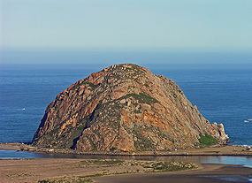
The town's most striking feature is Morro Rock, a 576 foot high volcanic plug
. Morro Rock stands at the entrance to the harbor, and a causeway connects it with the shore. Previously, it was surrounded by water, but the northern channel was filled in to make the harbor. The Rock, as locals call it, was quarried
from 1889 to 1969. There is no public access to the rock itself because it is a reserve for the locally endangered peregrine falcon
. However, the area around the base of Morro Rock can be visited. Every few years, someone is caught trying to climb the rock. Climbers risk more than fines or jail time as the rocks that form Morro Rock are loose and fall down regularly. The base of Morro Rock is littered with fallen boulders.
Morro Rock is one in a series of similar plugs that stretch in a line inland called the Nine Sisters
. It is possible that the landscape moved over a volcanic hot spot
through the ages.
and Monterey
. Morro Rock was originally surrounded by water, but the Army built a large artificial breakwater
and road across the north end of the harbor, linking Morro Rock and the mainland. Some of the rock used for this and for the artificial breakwaters was quarried from Morro Rock itself. Other rock was imported by barge from Catalina Island
. The bay extends inland and parallels the shore for a distance of about 6.4 km (4 miles) south of its entrance at Morro Rock. Morro Bay is recognized for protection by the California Bays and Estuaries Policy
.
Only relatively small craft are capable of passing the harbor channel. A large natural sandspit
, augmented by breakwaters, protects the harbor from the Pacific Ocean
to the west. At its northern end, remains of a bridge that used to connect the shore with the sandspit can be seen. Morro Bay Harbor's channel silts up and must be dredged every three to four years. Previously, the Shark Inlet connected the back bay to the ocean. Some have proposed reopening it to slow the sedimentation that is filling up the bay. There has also been work on reducing erosion
in the Chorro Creek watershed
to reduce the amount of sediment coming into the bay to form bottom layers of bay mud
. Chorro Creek is the bay's largest tributary. It forms an estuary in the back bay between Morro Bay and Los Osos. The second largest tributary, and the only other significant one, is Los Osos Creek, which empties into the far south end of the back bay.
Mariners are strongly urged to seek local advice prior to making use of the channel, especially when whitecaps or wind-blown water is evident or a small craft advisory
is in effect, which is very often. The United States Coast Guard
regards the harbor as one of the most dangerous in the entire nation, while others put it in the top six on the West Coast of the United States
. In 1995, the Army Corps of Engineering deepened and expanded the channel to improve safety. From 1979 to 1987, 21 lives were lost in boating accidents alone. However, many additional deaths have resulted from sightseers and fisherman being swept off the rocks of the breakwater surrounding Morro Rock. They often approach too closely to the waves and are caught off guard when a big wave set comes in. The slippery and jagged rocks only add to the danger. Public access to the breakwater has been revoked and those who venture beyond the signs do so at their own peril.
Coast Guard Station Morro Bay operates two small vessels. Limited transient vessel services are available. Yachtsmen may wish to contact the Morro Bay Yacht Club. A public boat launch ramp is available at the far south end of the Embarcadero.
The back bay, roughly anything south of the Morro Bay State Park Marina, is very shallow. However, there is some slightly deeper water in the channels. The largest channel continues from the bay's main channel, winding its way towards Los Osos
, on the southern end of the bay. The second largest breaks off from the largest about halfway to Los Osos and takes an extremely windy route to the sandspit. A few small channels on the landward side formed by runoff meet the largest channel as well. The narrow, unmarked channels are very hard to navigate and are filled with eel grass
, which can snag the boat
or clog the propeller
. They are easiest to find at low tide, but if the tide is too low, the boat may run aground because the channels are only a few feet deeper than the surrounding water. An alternative to searching for the channels is to cross at very high tide.
During World War II
, there was a U.S. Navy base on the north side of Morro Rock where sailors were trained to operate LCVP
s. The breakwater on the southwest side of the Rock was built in 1944-45 to protect the LCVPs entering and leaving the harbor. Soldiers from Camp San Luis Obispo would come to Morro Bay and practice loading into the LCVPs. Many of those men were at Normandy
on D-Day
.
(Köppen climate classification
Csb).
are marine protected areas offshore from Morro Bay. Like underwater parks, these marine protected areas help conserve ocean wildlife and marine ecosystems.
was 991.5 people per square mile (382.8/km²). The racial makeup of Morro Bay was 8,909 (87.1%) White, 44 (0.4%) African American, 92 (0.9%) Native American, 258 (2.5%) Asian, 9 (0.1%) Pacific Islander, 613 (6.0%) from other races
, and 309 (3.0%) from two or more races. Hispanic or Latino of any race were 1,526 persons (14.9%).
The Census reported that 10,073 people (98.4% of the population) lived in households, 36 (0.4%) lived in non-institutionalized group quarters, and 125 (1.2%) were institutionalized.
There were 4,844 households, out of which 919 (19.0%) had children under the age of 18 living in them, 1,972 (40.7%) were opposite-sex married couples
living together, 405 (8.4%) had a female householder with no husband present, 217 (4.5%) had a male householder with no wife present. There were 330 (6.8%) unmarried opposite-sex partnerships
, and 35 (0.7%) same-sex married couples or partnerships. 1,808 households (37.3%) were made up of individuals and 783 (16.2%) had someone living alone who was 65 years of age or older. The average household size was 2.08. There were 2,594 families
(53.6% of all households); the average family size was 2.70.
The population was spread out with 1,530 people (15.0%) under the age of 18, 815 people (8.0%) aged 18 to 24, 2,264 people (22.1%) aged 25 to 44, 3,200 people (31.3%) aged 45 to 64, and 2,425 people (23.7%) who were 65 years of age or older. The median age was 48.9 years. For every 100 females there were 95.8 males. For every 100 females age 18 and over, there were 93.6 males.
There were 6,320 housing units at an average density of 612.3 per square mile (236.4/km²), of which 2,583 (53.3%) were owner-occupied, and 2,261 (46.7%) were occupied by renters. The homeowner vacancy rate was 3.3%; the rental vacancy rate was 6.3%. 5,218 people (51.0% of the population) lived in owner-occupied housing units and 4,855 people (47.4%) lived in rental housing units.
, there were 10,350 people, 4,986 households, and 2,612 families residing in Morro Bay. The population density
was 2,006.9 people per square mile (774.4/km²). There were 6,251 housing units at an average density of 1,212.1 per square mile (467.7/km²). The racial makeup of the city was 89.44% White, 0.68% African American, 0.95% Native American, 1.81% Asian, 0.09% Pacific Islander, 4.10% from other races
, and 2.95% from two or more races. Hispanic or Latino of any race were 11.43% of the population.
There were 4,986 households out of which 16.7% had children under the age of 18 living with them, 40.5% were married couples
living together, 8.3% had a female householder with no husband present, and 47.6% were non-families. 38.0% of all households were made up of individuals and 16.4% had someone living alone who was 65 years of age or older. The average household size was 2.04 and the average family size was 2.65.
In the city the population was spread out with 15.1% under the age of 18, 8.4% from 18 to 24, 25.4% from 25 to 44, 26.8% from 45 to 64, and 24.2% who were 65 years of age or older. The median age was 46 years. For every 100 females there were 91.3 males. For every 100 females age 18 and over, there were 89.8 males.
The median income for a household in the city was $34,379, and the median income for a family was $43,508. Males had a median income of $31,073 versus $25,576 for females. The per capita income
for the city was $21,687. About 8.1% of families and 13.0% of the population were below the poverty line, including 16.9% of those under age 18 and 5.8% of those age 65 or over.
Morro Bay High School is the only school in Morro Bay, California that offers education for grade level 9th-12th.
Morro Bay is located in the 15th Senate
District, represented by Republican
Abel Maldonado
, and in the 33rd Assembly
District, represented by Republican Sam Blakeslee
. Federally, Morro Bay is located in California's 23rd congressional district
, which has a Cook PVI
of D +9 and is represented by Democrat
Lois Capps.
power plant, previously owned by Pacific Gas and Electric Company
, Duke Energy
, and LSPower (PG&E), plays a large role in Morro Bay, and in providing electricity to the Central Coast and the Central Valley of California (primarily Fresno
and Bakersfield). Its future is currently, as of 2007, uncertain. The current plant was built in the 1950s, and Dynegy wishes to modernize it with a new combined cycle
plant. Due primarily to economics, the plant is currently operating at relatively low capacity factors (approximately 5%) under contract with PG&E. The plant is currently staffed with 44 employees. A portion of the city's budget comes from tax on the natural gas
the plant burns. The outfall lease with the city was recently approved by the majority of the city council. Activists are opposed to the new plant. The United States Environmental Protection Agency (EPA) and the courts are currently wrestling with how to interpret the Clean Water Act
(CWA) and its applicability to power plants. The EPA has ruled that the local Regional Water Quality Control Boards are responsible for ensuring that the current and the future plant are permitted and regulated. If the proposed plant is eventually built, the old power plant and its 450 ft. tall stacks will be removed. The modernized plant would be located slightly northwest of the existing plant, and its stacks would be much shorter (145 ft).
San Luis Obispo County, California
San Luis Obispo County is a county located along the Pacific Ocean in the Central Coast of the U.S. state of California, between Los Angeles and the San Francisco Bay Area. As of the 2010 census its population was 269,637, up from 246,681 at the 2000 census...
, California
California
California is a state located on the West Coast of the United States. It is by far the most populous U.S. state, and the third-largest by land area...
, United States
United States
The United States of America is a federal constitutional republic comprising fifty states and a federal district...
. As of the 2010 census
United States Census, 2010
The Twenty-third United States Census, known as Census 2010 or the 2010 Census, is the current national census of the United States. National Census Day was April 1, 2010 and is the reference date used in enumerating individuals...
, the city population was 10,234, down from 10,350 at the 2000 census.
History
The prehistory of Morro Bay relates to Chumash settlement, particularly near the mouth of Morro CreekMorro Creek
Morro Creek is a coastal stream in San Luis Obispo County, California, USA. This watercourse discharges to the Pacific Ocean at the city of Morro Bay.-Natural history:...
. At least as early as the Millingstone Horizon
Millingstone Horizon
Millingstone Horizon is an archaeological period of Native American dominance denoting a period in California, USA involving extensive use of manos and other grinding technology. The interval is a subset of the Archaic Period; specifically Millingstone is usually applied to the period 6500 to...
thousands of years before present, there was an extensive settlement along the banks and terraces above Morro Creek.
Morro Rock was named in 1542 by Portuguese navigator Juan Rodríguez Cabrillo
Juan Rodríguez Cabrillo
Juan Rodriguez Cabrillo was a Portuguese explorer noted for his exploration of the west coast of North America on behalf of Spain. Cabrillo was the first European explorer to navigate the coast of present day California in the United States...
, who explored the Pacific Coast for Spain
Spain
Spain , officially the Kingdom of Spain languages]] under the European Charter for Regional or Minority Languages. In each of these, Spain's official name is as follows:;;;;;;), is a country and member state of the European Union located in southwestern Europe on the Iberian Peninsula...
. Cabrillo called the rock El Moro because it resembled the head of a Moor
Moors
The description Moors has referred to several historic and modern populations of the Maghreb region who are predominately of Berber and Arab descent. They came to conquer and rule the Iberian Peninsula for nearly 800 years. At that time they were Muslim, although earlier the people had followed...
, the people from North Africa known for the turbans they wore. However, the dictionary definition for the Spanish word "morro" ("pebble") is also consistent with the shape of the rock, and so the term morro is frequently used wherever such a distinctive rock-like mountain is found within the Spanish speaking world.
The first recorded Filipino immigrants to America arrived at Morro Bay on October 18, 1587, from the Spanish galleon Nuestra Señora de Esperanza.
While governed by Mexico
Mexico
The United Mexican States , commonly known as Mexico , is a federal constitutional republic in North America. It is bordered on the north by the United States; on the south and west by the Pacific Ocean; on the southeast by Guatemala, Belize, and the Caribbean Sea; and on the east by the Gulf of...
, large land grant
Land grant
A land grant is a gift of real estate – land or its privileges – made by a government or other authority as a reward for services to an individual, especially in return for military service...
s split the surrounding area into cattle and dairy ranchos. These ranchos needed shipping to bring in dry goods and to carry their crops, animals, and other farm products to cities. Thus, Morro Bay grew.
The town of Morro Bay was founded by Franklin Riley in 1870 as a port for the export of dairy and ranch products. He was instrumental in the building of a wharf
Wharf
A wharf or quay is a structure on the shore of a harbor where ships may dock to load and unload cargo or passengers.Such a structure includes one or more berths , and may also include piers, warehouses, or other facilities necessary for handling the ships.A wharf commonly comprises a fixed...
which has now become the Embarcadero. During the 1870s, schooner
Schooner
A schooner is a type of sailing vessel characterized by the use of fore-and-aft sails on two or more masts with the forward mast being no taller than the rear masts....
s could often be seen at the Embarcadero picking up wool, potatoes, barley, and dairy products.
Since the beginning of the 20th century, the town has been a center for beach holidays. Tourism is the city's largest industry. The most popular beach is on the north side of Morro Rock
Morro Rock
Morro Rock is a volcanic plug located just offshore from Morro Bay, California, at the entrance to Morro Bay Harbor. A causeway connects it with the shore, effectively making it a tied island. The area surrounding the base of Morro Rock can be visited. The rock is protected as the Morro Rock State...
, north of the harbor. There are also excellent beaches north and south of the town which are now owned by the State of California.
In the 1940s, Morro Bay developed an abalone
Abalone
Abalone , from aulón, are small to very large-sized edible sea snails, marine gastropod molluscs in the family Haliotidae and the genus Haliotis...
fishing industry. Having peaked in 1957, stocks of abalone have now declined signicantly due to overfishing, it remains a fishing port for halibut
Halibut
Halibut is a flatfish, genus Hippoglossus, from the family of the right-eye flounders . Other flatfish are also called halibut. The name is derived from haly and butt , for its popularity on Catholic holy days...
, sole
Sole (fish)
Sole is a group of flatfish belonging to several families. Generally speaking, they are members of the family Soleidae, but, outside Europe, the name sole is also applied to various other similar flatfish, especially other members of the sole suborder Soleoidei as well as members of the flounder...
, rockfish
Sebastidae
Sebastidae is a family of marine fish in the order Scorpaeniformes. Their common names include rockfishes, thornyheads and rockcods. Despite the latter name, they are not closely related to the cods in the genus Gadus, nor the rock cod, Lotella rhacina.Not all authorities recognise this family as...
, albacore
Albacore
The albacore, Thunnus alalunga, is a type of tuna in the family Scombridae. This species is also called albacore fish, albacore tuna, albicore, longfin, albies, pigfish, tombo ahi, binnaga, Pacific albacore, German bonito , longfin tuna, longfin tunny, or even just tuna...
, and many other species for both commercial and sport vessels. The town now combines the fishing industry with coastal tourism. In addition, oyster
Oyster
The word oyster is used as a common name for a number of distinct groups of bivalve molluscs which live in marine or brackish habitats. The valves are highly calcified....
s are farmed artificially
Aquaculture
Aquaculture, also known as aquafarming, is the farming of aquatic organisms such as fish, crustaceans, molluscs and aquatic plants. Aquaculture involves cultivating freshwater and saltwater populations under controlled conditions, and can be contrasted with commercial fishing, which is the...
in the shallow back bay.
A portion of Morro Bay is also designated as a state and national bird sanctuary. This means it is illegal to kill or harm a bird in that portion of Morro Bay. It is also a state and national estuary
Estuary
An estuary is a partly enclosed coastal body of water with one or more rivers or streams flowing into it, and with a free connection to the open sea....
. Much of Morro Bay is a state wildlife refuge where waterfowl hunting is conducted during the season and is one of the few areas in California where Pacific Brant are pursued. Recently, Morro Bay was also declared a California Marine Reserve by the California Fish and Game Commission.
Geography
Morro Bay is located at 35°22′45"N 120°51′12"W (35.379043, -120.853354). Morro Bay 35°20′16"N 120°51′05"W is also the name of the large estuary that is situated along the northern shores of the bay itself. The larger bay on which the local area lies is Estero BayEstero Bay (California)
Estero Bay is a bay located on the Pacific Coast of California in the United States. Towns on the bay include Morro Bay and Los Osos. Two state beaches at the edge of the bay are Atascadero State Beach and Morro Strand State Beach.-References:...
, which also encompasses the communities of Cayucos
Cayucos, California
Cayucos is a census-designated place located on the coast in San Luis Obispo County, California along California State Route 1 between Cambria to the north and Morro Bay to the south...
and Los Osos
Los Osos, California
Los Osos is an unincorporated area and a census-designated place located along the Pacific coast of San Luis Obispo County, California. The community is part of the 93402 and 93412 ZIP Codes and area code 805. The population was 14,276 at the 2010 census....
. The city of Morro Bay is 20 km (12 mi) northwest of San Luis Obispo and is located on Highway 1
California State Route 1
State Route 1 , more often called Highway 1, is a state highway that runs along much of the Pacific coast of the U.S. state of California. It is famous for running along some of the most beautiful coastlines in the world, leading to its designation as an All-American Road.Highway 1 does not run...
. Los Osos Creek
Los Osos Creek
Los Osos Creek is a stream in coastal San Luis Obispo County that discharges to Morro Bay. Los Osos Creek rises in the Clark Valley on the slopes of the Irish Hills. After flowing through Clark Valley, Los Osos Creek flows into Los Osos Valley...
discharges into Morro Bay.
According to the United States Census Bureau
United States Census Bureau
The United States Census Bureau is the government agency that is responsible for the United States Census. It also gathers other national demographic and economic data...
, the city has a total area of 10.3 square miles (26.7 km²), of which, 5.3 square miles (13.7 km²) of it is land and 5 square miles (12.9 km²) of it (48.63%) is water.
Morro Rock
The town's most striking feature is Morro Rock, a 576 foot high volcanic plug
Volcanic plug
A volcanic plug, also called a volcanic neck or lava neck, is a volcanic landform created when magma hardens within a vent on an active volcano. When forming, a plug can cause an extreme build-up of pressure if volatile-charged magma is trapped beneath it, and this can sometimes lead to an...
. Morro Rock stands at the entrance to the harbor, and a causeway connects it with the shore. Previously, it was surrounded by water, but the northern channel was filled in to make the harbor. The Rock, as locals call it, was quarried
Quarry
A quarry is a type of open-pit mine from which rock or minerals are extracted. Quarries are generally used for extracting building materials, such as dimension stone, construction aggregate, riprap, sand, and gravel. They are often collocated with concrete and asphalt plants due to the requirement...
from 1889 to 1969. There is no public access to the rock itself because it is a reserve for the locally endangered peregrine falcon
Peregrine Falcon
The Peregrine Falcon , also known as the Peregrine, and historically as the Duck Hawk in North America, is a widespread bird of prey in the family Falconidae. A large, crow-sized falcon, it has a blue-gray back, barred white underparts, and a black head and "moustache"...
. However, the area around the base of Morro Rock can be visited. Every few years, someone is caught trying to climb the rock. Climbers risk more than fines or jail time as the rocks that form Morro Rock are loose and fall down regularly. The base of Morro Rock is littered with fallen boulders.
Morro Rock is one in a series of similar plugs that stretch in a line inland called the Nine Sisters
Nine Sisters
The Nine Sisters or the Morros are a chain of nine volcanic peaks and hills between Morro Bay and San Luis Obispo, California. They are popular with photographers and rock climbers. Their volcanic origin makes them of significant geological interest. They support a wide variety of plant, animal,...
. It is possible that the landscape moved over a volcanic hot spot
Hotspot (geology)
The places known as hotspots or hot spots in geology are volcanic regions thought to be fed by underlying mantle that is anomalously hot compared with the mantle elsewhere. They may be on, near to, or far from tectonic plate boundaries. There are two hypotheses to explain them...
through the ages.
Morro Bay Harbor
Morro Bay is a natural embayment with an artificial harbor constructed by the U.S. Army Corps of Engineers. It is the only all-weather small craft commercial and recreational harbor between Santa BarbaraSanta Barbara, California
Santa Barbara is the county seat of Santa Barbara County, California, United States. Situated on an east-west trending section of coastline, the longest such section on the West Coast of the United States, the city lies between the steeply-rising Santa Ynez Mountains and the Pacific Ocean...
and Monterey
Monterey, California
The City of Monterey in Monterey County is located on Monterey Bay along the Pacific coast in Central California. Monterey lies at an elevation of 26 feet above sea level. As of the 2010 census, the city population was 27,810. Monterey is of historical importance because it was the capital of...
. Morro Rock was originally surrounded by water, but the Army built a large artificial breakwater
Breakwater (structure)
Breakwaters are structures constructed on coasts as part of coastal defence or to protect an anchorage from the effects of weather and longshore drift.-Purposes of breakwaters:...
and road across the north end of the harbor, linking Morro Rock and the mainland. Some of the rock used for this and for the artificial breakwaters was quarried from Morro Rock itself. Other rock was imported by barge from Catalina Island
Santa Catalina Island, California
Santa Catalina Island, often called Catalina Island, or just Catalina, is a rocky island off the coast of the U.S. state of California. The island is long and across at its greatest width. The island is located about south-southwest of Los Angeles, California. The highest point on the island is...
. The bay extends inland and parallels the shore for a distance of about 6.4 km (4 miles) south of its entrance at Morro Rock. Morro Bay is recognized for protection by the California Bays and Estuaries Policy
California Bays and Estuaries Policy
The Water Quality Control Policy for the Enclosed Bays and Estuaries of California is published by the California State Water Resources Control Board as guidelines to prevent water quality degradation. The policy is revised as needed.-Geography:...
.
Only relatively small craft are capable of passing the harbor channel. A large natural sandspit
Sandspit
Sandspit may refer to:* Sandspit, British Columbia, a town on Haida Gwaii, British Columbia, Canada* Sandspit Beach, a major tourist site in Karachi, Pakistan* Sandspit , a deposition landform found off coasts...
, augmented by breakwaters, protects the harbor from the Pacific Ocean
Pacific Ocean
The Pacific Ocean is the largest of the Earth's oceanic divisions. It extends from the Arctic in the north to the Southern Ocean in the south, bounded by Asia and Australia in the west, and the Americas in the east.At 165.2 million square kilometres in area, this largest division of the World...
to the west. At its northern end, remains of a bridge that used to connect the shore with the sandspit can be seen. Morro Bay Harbor's channel silts up and must be dredged every three to four years. Previously, the Shark Inlet connected the back bay to the ocean. Some have proposed reopening it to slow the sedimentation that is filling up the bay. There has also been work on reducing erosion
Erosion
Erosion is when materials are removed from the surface and changed into something else. It only works by hydraulic actions and transport of solids in the natural environment, and leads to the deposition of these materials elsewhere...
in the Chorro Creek watershed
Drainage basin
A drainage basin is an extent or an area of land where surface water from rain and melting snow or ice converges to a single point, usually the exit of the basin, where the waters join another waterbody, such as a river, lake, reservoir, estuary, wetland, sea, or ocean...
to reduce the amount of sediment coming into the bay to form bottom layers of bay mud
Bay mud
Bay mud consists of thick deposits of soft, unconsolidated silty clay, which is saturated with water; these soil layers are situated at the bottom of certain estuaries, which are normally in temperate regions that have experienced cyclical glacial cycles...
. Chorro Creek is the bay's largest tributary. It forms an estuary in the back bay between Morro Bay and Los Osos. The second largest tributary, and the only other significant one, is Los Osos Creek, which empties into the far south end of the back bay.
Mariners are strongly urged to seek local advice prior to making use of the channel, especially when whitecaps or wind-blown water is evident or a small craft advisory
Small craft advisory
A small craft advisory is a type of warning issued by the National Weather Service in the United States, most frequently in coastal areas. It is issued when winds have reached, or are expected to reach within 12 hours, a speed marginally less than gale force....
is in effect, which is very often. The United States Coast Guard
United States Coast Guard
The United States Coast Guard is a branch of the United States Armed Forces and one of the seven U.S. uniformed services. The Coast Guard is a maritime, military, multi-mission service unique among the military branches for having a maritime law enforcement mission and a federal regulatory agency...
regards the harbor as one of the most dangerous in the entire nation, while others put it in the top six on the West Coast of the United States
West Coast of the United States
West Coast or Pacific Coast are terms for the westernmost coastal states of the United States. The term most often refers to the states of California, Oregon, and Washington. Although not part of the contiguous United States, Alaska and Hawaii do border the Pacific Ocean but can't be included in...
. In 1995, the Army Corps of Engineering deepened and expanded the channel to improve safety. From 1979 to 1987, 21 lives were lost in boating accidents alone. However, many additional deaths have resulted from sightseers and fisherman being swept off the rocks of the breakwater surrounding Morro Rock. They often approach too closely to the waves and are caught off guard when a big wave set comes in. The slippery and jagged rocks only add to the danger. Public access to the breakwater has been revoked and those who venture beyond the signs do so at their own peril.
Coast Guard Station Morro Bay operates two small vessels. Limited transient vessel services are available. Yachtsmen may wish to contact the Morro Bay Yacht Club. A public boat launch ramp is available at the far south end of the Embarcadero.
The back bay, roughly anything south of the Morro Bay State Park Marina, is very shallow. However, there is some slightly deeper water in the channels. The largest channel continues from the bay's main channel, winding its way towards Los Osos
Los Osos, California
Los Osos is an unincorporated area and a census-designated place located along the Pacific coast of San Luis Obispo County, California. The community is part of the 93402 and 93412 ZIP Codes and area code 805. The population was 14,276 at the 2010 census....
, on the southern end of the bay. The second largest breaks off from the largest about halfway to Los Osos and takes an extremely windy route to the sandspit. A few small channels on the landward side formed by runoff meet the largest channel as well. The narrow, unmarked channels are very hard to navigate and are filled with eel grass
Zostera
Zostera is a small genus of widely distributed seagrass, commonly called marine eelgrass or simply eelgrass . The genus Zostera contains sixteen species.-Ecology:Zostera is found on sandy substrates or in estuaries submerged or partially floating...
, which can snag the boat
Boat
A boat is a watercraft of any size designed to float or plane, to provide passage across water. Usually this water will be inland or in protected coastal areas. However, boats such as the whaleboat were designed to be operated from a ship in an offshore environment. In naval terms, a boat is a...
or clog the propeller
Propeller
A propeller is a type of fan that transmits power by converting rotational motion into thrust. A pressure difference is produced between the forward and rear surfaces of the airfoil-shaped blade, and a fluid is accelerated behind the blade. Propeller dynamics can be modeled by both Bernoulli's...
. They are easiest to find at low tide, but if the tide is too low, the boat may run aground because the channels are only a few feet deeper than the surrounding water. An alternative to searching for the channels is to cross at very high tide.
During World War II
World War II
World War II, or the Second World War , was a global conflict lasting from 1939 to 1945, involving most of the world's nations—including all of the great powers—eventually forming two opposing military alliances: the Allies and the Axis...
, there was a U.S. Navy base on the north side of Morro Rock where sailors were trained to operate LCVP
LCVP
The Landing Craft, Vehicle, Personnel or Higgins boat was a landing craft used extensively in amphibious landings in World War II. The craft was designed by Andrew Higgins of Louisiana, United States, based on boats made for operating in swamps and marshes...
s. The breakwater on the southwest side of the Rock was built in 1944-45 to protect the LCVPs entering and leaving the harbor. Soldiers from Camp San Luis Obispo would come to Morro Bay and practice loading into the LCVPs. Many of those men were at Normandy
Normandy
Normandy is a geographical region corresponding to the former Duchy of Normandy. It is in France.The continental territory covers 30,627 km² and forms the preponderant part of Normandy and roughly 5% of the territory of France. It is divided for administrative purposes into two régions:...
on D-Day
D-Day
D-Day is a term often used in military parlance to denote the day on which a combat attack or operation is to be initiated. "D-Day" often represents a variable, designating the day upon which some significant event will occur or has occurred; see Military designation of days and hours for similar...
.
Climate
Morro Bay experiences a Mediterranean climateMediterranean climate
A Mediterranean climate is the climate typical of most of the lands in the Mediterranean Basin, and is a particular variety of subtropical climate...
(Köppen climate classification
Köppen climate classification
The Köppen climate classification is one of the most widely used climate classification systems. It was first published by Crimea German climatologist Wladimir Köppen in 1884, with several later modifications by Köppen himself, notably in 1918 and 1936...
Csb).
Marine Protected Areas
Morro Bay State Marine Recreational Management Area and Morro Bay State Marine ReserveMorro Bay State Marine Recreational Management Area and Morro Bay State Marine Reserve
Morro Bay State Marine Recreational Management Area and Morro Bay State Marine Reserve are two marine protected areas that provide protection for Morro Bay Estuary on California’s central coast. The two marine protected areas together encompass...
are marine protected areas offshore from Morro Bay. Like underwater parks, these marine protected areas help conserve ocean wildlife and marine ecosystems.
Economy
A number of tourist attractions are found along the shoreline and the streets closest to it, especially the Embarcadero, including restaurants, shops and parks.2010
The 2010 United States Census reported that Morro Bay had a population of 10,234. The population densityPopulation density
Population density is a measurement of population per unit area or unit volume. It is frequently applied to living organisms, and particularly to humans...
was 991.5 people per square mile (382.8/km²). The racial makeup of Morro Bay was 8,909 (87.1%) White, 44 (0.4%) African American, 92 (0.9%) Native American, 258 (2.5%) Asian, 9 (0.1%) Pacific Islander, 613 (6.0%) from other races
Race (United States Census)
Race and ethnicity in the United States Census, as defined by the Federal Office of Management and Budget and the United States Census Bureau, are self-identification data items in which residents choose the race or races with which they most closely identify, and indicate whether or not they are...
, and 309 (3.0%) from two or more races. Hispanic or Latino of any race were 1,526 persons (14.9%).
The Census reported that 10,073 people (98.4% of the population) lived in households, 36 (0.4%) lived in non-institutionalized group quarters, and 125 (1.2%) were institutionalized.
There were 4,844 households, out of which 919 (19.0%) had children under the age of 18 living in them, 1,972 (40.7%) were opposite-sex married couples
Marriage
Marriage is a social union or legal contract between people that creates kinship. It is an institution in which interpersonal relationships, usually intimate and sexual, are acknowledged in a variety of ways, depending on the culture or subculture in which it is found...
living together, 405 (8.4%) had a female householder with no husband present, 217 (4.5%) had a male householder with no wife present. There were 330 (6.8%) unmarried opposite-sex partnerships
POSSLQ
POSSLQ is an abbreviation for "Persons of Opposite Sex Sharing Living Quarters," a term coined in the late 1970s by the United States Census Bureau as part of an effort to more accurately gauge the prevalence of cohabitation in American households....
, and 35 (0.7%) same-sex married couples or partnerships. 1,808 households (37.3%) were made up of individuals and 783 (16.2%) had someone living alone who was 65 years of age or older. The average household size was 2.08. There were 2,594 families
Family (U.S. Census)
A family or family household is defined by the United States Census Bureau for statistical purposes as "a householder and one or more other people related to the householder by birth, marriage, or adoption. They do not include same-sex married couples even if the marriage was performed in a state...
(53.6% of all households); the average family size was 2.70.
The population was spread out with 1,530 people (15.0%) under the age of 18, 815 people (8.0%) aged 18 to 24, 2,264 people (22.1%) aged 25 to 44, 3,200 people (31.3%) aged 45 to 64, and 2,425 people (23.7%) who were 65 years of age or older. The median age was 48.9 years. For every 100 females there were 95.8 males. For every 100 females age 18 and over, there were 93.6 males.
There were 6,320 housing units at an average density of 612.3 per square mile (236.4/km²), of which 2,583 (53.3%) were owner-occupied, and 2,261 (46.7%) were occupied by renters. The homeowner vacancy rate was 3.3%; the rental vacancy rate was 6.3%. 5,218 people (51.0% of the population) lived in owner-occupied housing units and 4,855 people (47.4%) lived in rental housing units.
2000
As of the 2000 censusUnited States Census, 2000
The Twenty-second United States Census, known as Census 2000 and conducted by the Census Bureau, determined the resident population of the United States on April 1, 2000, to be 281,421,906, an increase of 13.2% over the 248,709,873 persons enumerated during the 1990 Census...
, there were 10,350 people, 4,986 households, and 2,612 families residing in Morro Bay. The population density
Population density
Population density is a measurement of population per unit area or unit volume. It is frequently applied to living organisms, and particularly to humans...
was 2,006.9 people per square mile (774.4/km²). There were 6,251 housing units at an average density of 1,212.1 per square mile (467.7/km²). The racial makeup of the city was 89.44% White, 0.68% African American, 0.95% Native American, 1.81% Asian, 0.09% Pacific Islander, 4.10% from other races
Race (United States Census)
Race and ethnicity in the United States Census, as defined by the Federal Office of Management and Budget and the United States Census Bureau, are self-identification data items in which residents choose the race or races with which they most closely identify, and indicate whether or not they are...
, and 2.95% from two or more races. Hispanic or Latino of any race were 11.43% of the population.
There were 4,986 households out of which 16.7% had children under the age of 18 living with them, 40.5% were married couples
Marriage
Marriage is a social union or legal contract between people that creates kinship. It is an institution in which interpersonal relationships, usually intimate and sexual, are acknowledged in a variety of ways, depending on the culture or subculture in which it is found...
living together, 8.3% had a female householder with no husband present, and 47.6% were non-families. 38.0% of all households were made up of individuals and 16.4% had someone living alone who was 65 years of age or older. The average household size was 2.04 and the average family size was 2.65.
In the city the population was spread out with 15.1% under the age of 18, 8.4% from 18 to 24, 25.4% from 25 to 44, 26.8% from 45 to 64, and 24.2% who were 65 years of age or older. The median age was 46 years. For every 100 females there were 91.3 males. For every 100 females age 18 and over, there were 89.8 males.
The median income for a household in the city was $34,379, and the median income for a family was $43,508. Males had a median income of $31,073 versus $25,576 for females. The per capita income
Per capita income
Per capita income or income per person is a measure of mean income within an economic aggregate, such as a country or city. It is calculated by taking a measure of all sources of income in the aggregate and dividing it by the total population...
for the city was $21,687. About 8.1% of families and 13.0% of the population were below the poverty line, including 16.9% of those under age 18 and 5.8% of those age 65 or over.
Morro Bay High School is the only school in Morro Bay, California that offers education for grade level 9th-12th.
Politics
In the state legislatureCalifornia State Legislature
The California State Legislature is the state legislature of the U.S. state of California. It is a bicameral body consisting of the lower house, the California State Assembly, with 80 members, and the upper house, the California State Senate, with 40 members...
Morro Bay is located in the 15th Senate
California State Senate
The California State Senate is the upper house of the California State Legislature. There are 40 state senators. The state legislature meets in the California State Capitol in Sacramento. The Lieutenant Governor is the ex officio President of the Senate and may break a tied vote...
District, represented by Republican
Republican Party (United States)
The Republican Party is one of the two major contemporary political parties in the United States, along with the Democratic Party. Founded by anti-slavery expansion activists in 1854, it is often called the GOP . The party's platform generally reflects American conservatism in the U.S...
Abel Maldonado
Abel Maldonado
Abel Maldonado is an American politician who was the 48th Lieutenant Governor of California. On November 23, 2009, then-Governor Arnold Schwarzenegger announced Maldonado as his nominee for Lieutenant Governor to fill the vacancy created by John Garamendi's election to the United States House of...
, and in the 33rd Assembly
California State Assembly
The California State Assembly is the lower house of the California State Legislature. There are 80 members in the Assembly, representing an approximately equal number of constituents, with each district having a population of at least 420,000...
District, represented by Republican Sam Blakeslee
Sam Blakeslee
Samuel Norman Blakeslee is a Republican California State Senator representing California's 15th State Senate district, a former California State Assemblyman from California's 33rd State Assembly district, and a former State Assembly Republican Leader...
. Federally, Morro Bay is located in California's 23rd congressional district
California's 23rd congressional district
California's 23rd congressional district is a congressional district in the U.S. state of California that runs along the Pacific coasts of Ventura, Santa Barbara and San Luis Obispo counties...
, which has a Cook PVI
Cook Partisan Voting Index
The Cook Partisan Voting Index , sometimes referred to as simply the Partisan Voting Index , is a measurement of how strongly an American congressional district or state leans toward one political party compared to the nation as a whole...
of D +9 and is represented by Democrat
Democratic Party (United States)
The Democratic Party is one of two major contemporary political parties in the United States, along with the Republican Party. The party's socially liberal and progressive platform is largely considered center-left in the U.S. political spectrum. The party has the lengthiest record of continuous...
Lois Capps.
Power plant
The DynegyDynegy
Dynegy Inc. , based in Houston, Texas, United States, is a large owner and operator of power plants and a player in the natural gas liquids and coal business...
power plant, previously owned by Pacific Gas and Electric Company
Pacific Gas and Electric Company
The Pacific Gas and Electric Company , commonly known as PG&E, is the utility that provides natural gas and electricity to most of the northern two-thirds of California, from Bakersfield almost to the Oregon border...
, Duke Energy
Duke Energy
Duke Energy , headquartered in Charlotte, North Carolina, is an energy company with assets in the United States, Canada and Latin America.-Overview:...
, and LSPower (PG&E), plays a large role in Morro Bay, and in providing electricity to the Central Coast and the Central Valley of California (primarily Fresno
Fresno
Fresno is the fifth largest city in California.Fresno may also refer to:-Places:Colombia* Fresno, TolimaSpain* Fresno, a ghost village in Nidáliga, Valle de Sedano, Burgos* Aldea del Fresno, Madrid* Fresno de la Vega, Ribera del Esla, León...
and Bakersfield). Its future is currently, as of 2007, uncertain. The current plant was built in the 1950s, and Dynegy wishes to modernize it with a new combined cycle
Combined cycle
In electric power generation a combined cycle is an assembly of heat engines that work in tandem off the same source of heat, converting it into mechanical energy, which in turn usually drives electrical generators...
plant. Due primarily to economics, the plant is currently operating at relatively low capacity factors (approximately 5%) under contract with PG&E. The plant is currently staffed with 44 employees. A portion of the city's budget comes from tax on the natural gas
Natural gas
Natural gas is a naturally occurring gas mixture consisting primarily of methane, typically with 0–20% higher hydrocarbons . It is found associated with other hydrocarbon fuel, in coal beds, as methane clathrates, and is an important fuel source and a major feedstock for fertilizers.Most natural...
the plant burns. The outfall lease with the city was recently approved by the majority of the city council. Activists are opposed to the new plant. The United States Environmental Protection Agency (EPA) and the courts are currently wrestling with how to interpret the Clean Water Act
Clean Water Act
The Clean Water Act is the primary federal law in the United States governing water pollution. Commonly abbreviated as the CWA, the act established the goals of eliminating releases of high amounts of toxic substances into water, eliminating additional water pollution by 1985, and ensuring that...
(CWA) and its applicability to power plants. The EPA has ruled that the local Regional Water Quality Control Boards are responsible for ensuring that the current and the future plant are permitted and regulated. If the proposed plant is eventually built, the old power plant and its 450 ft. tall stacks will be removed. The modernized plant would be located slightly northwest of the existing plant, and its stacks would be much shorter (145 ft).
Notable residents
- George Ramos, born in East Los Angeles in 1948, died in Morro Bay in July 2011 at age 63. Ramos earned a Purple Heart during the Vietnam War and won three Pulitzers for the Los Angeles Times, before he returned to his alma mater Cal Poly San Luis Obispo as the head of the journalism department in 2003. At the time of his death, Ramos was a tenured professor of journalism at Cal Poly and editor of Cal Coast News.
- Jack LaLanneJack LaLanneFrancois Henri "Jack" LaLanne was an American fitness, exercise, and nutritional expert and motivational speaker who is sometimes called "the godfather of fitness" and the "first fitness superhero." He described himself as being a "sugarholic" and a "junk food junkie" until he was 15...
, Born in San Francisco, Sept. 26, 1914 - Died in Morro Bay of pnemonia, Jan. 23, 2011, age 96. Mr. LaLanne was an originator of the diet and exercise movement in the USA. - Camille Katz born 8/29/2011 famous singer went to Morro Bay high school graduating class of 2001.
- Greg Garman drummer for Selena Gomez.